East Midtown-Turtle Bay
Neighborhood · Manhattan
From Grand Central Terminal on 42nd Street, East Midtown-Turtle Bay reaches east to the East River, taking in Turtle Bay, Beekman Place and the Sutton Place area to the north.
- 0.47 square miles
- 45,765 residents, 2020 Census
- 91 street corners
- 3 subway stations
- 48 bus routes
Turtle Bay is named for a former East River cove between 45th and 48th Streets, and the area began as a farm granted by the Dutch colonial governor in 1639; the cove had been filled in by 1868. Grand Central Terminal, completed in 1913 in the French Beaux-Arts style, became a city landmark in 1967. Between 1918 and 1920, twenty row houses on East 48th and 49th Streets became the Turtle Bay Gardens enclave, now a historic district.
Sources: Turtle Bay, Manhattan (Wikipedia); Grand Central Terminal, 71-105 East 42nd Street (LP-0266, August 2, 1967) (NYC Landmarks Preservation Commission).
East Midtown-Turtle Bay borders five areas, and Lexington Avenue holds more of its corners than any other street, 17 of 91.
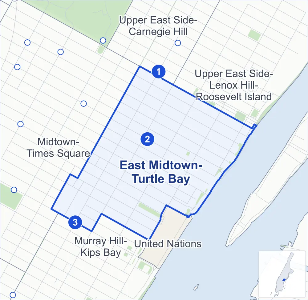
- East Midtown-Turtle Bay
- A neighboring area
- Park
- A station in the list
- Another station
Neighborhood areas and streets: NYC Department of City Planning. Parks: NYC Parks. Stations: MTA.
Neighboring areas
- Upper East Side-Carnegie Hill north
- Upper East Side-Lenox Hill-Roosevelt Island northeast
- United Nations south
- Murray Hill-Kips Bay southwest
- Midtown-Times Square west
Subway stations
- 59 St lines 4 5 6
- 51 St / Lexington Av/53 St lines 6 E F accessible
- Grand Central-42 St lines 4 5 6 7 accessible
Getting around
Three subway stations and buses on 48 routes stop in or at the edge of East Midtown-Turtle Bay.
- 3 subway stations
- 2 of them listed by the MTA as fully accessible
- 10 local bus routes
- 38 express bus routes
Local bus routes
- M15
- M15-SBS
- M31
- M42
- M50
- M57
- M101
- M102
- M103
- Q32
Express bus routes
- BM1
- BM2
- BM3
- BM4
- BM5
- BxM1
- QM1
- QM2
- QM4
- QM5
- QM6
- QM10
- QM12
- QM15
- QM16
- QM17
- QM18
- QM20
- QM21
- QM24
- QM31
- QM32
- QM34
- QM35
- QM36
- QM40
- QM42
- QM44
- QM63
- QM64
- QM68
- SIM6
- SIM8
- SIM11
- SIM22
- SIM25
- SIM26
- SIM31
Safety record
Between 2021 and 2025, its corners averaged more police-reported crashes than the average Manhattan corner.
- 1,677 police-reported crashes at its corners
- 18.4 a corner, on average
- 13.4 the average Manhattan corner
- 5 corners with a clean record
Signal or safety changes on City record, at 60 of its corners
- Leading pedestrian intervals
- 54
- Accessible pedestrian signals
- 15
- Turn calming
- 14
- Barnes Dance all-way crossings
- 4
- Safety Improvement Projects
- 2
Camera tickets
In 2025 its corners had more bus-lane camera tickets than school-zone speed or red-light tickets.
- 0 red-light camera tickets
- 1,450 school-zone speed camera tickets at one corner
- 10,946 bus-lane camera tickets at six corners
- Most speed tickets
- 2nd Avenue & East 56th Street, 1,450
- Most bus-lane tickets
- 2nd Avenue & East 45th Street, 6,191
People and homes
The 2020 Census counted 45,765 residents in East Midtown-Turtle Bay, about 97,400 per square mile.
- 32,087 homes, 2020 Census
- 1,883 homes added since April 2010, net, by City Planning's count
Half of its 765 residential lots hold buildings from 1920 or earlier, and 72% of them date from before 1940, by the City's tax lot records.
Parks and landmarks
- Parkland
- 3.8 acres of NYC Parks property
- The largest pieces
- Dag Hammarskjold Plaza (1.6 acres), Sutton Parks (0.8 acre) and Peter Detmold Park (0.6 acre)
- Designated landmarks
- The Graybar Building, the Amster Yard, the Central Synagogue and the Citicorp Center and Saint Peter's Church, among others
- Historic district
- Turtle Bay Gardens Historic District, wholly or partly within East Midtown-Turtle Bay
Streets and trees
- Trees
- 1,982 in NYC Parks' records, most often thornless honeylocust, maidenhair tree and Callery pear
- Street with the most corners
- Lexington Avenue, with 17 of the area's 91
- Height above sea level
- From 9 feet at FDR Drive & East 49th Street to 66 feet at Queensboro Bridge & East 58th Street
- Honorary street name
- 1 at its corners, enacted by local law
Schools and libraries
The City lists six schools and two libraries in East Midtown-Turtle Bay.
- Public schools
- 2
- Charter and private schools
- 4
- Libraries
- 58th Street Library and Terence Cardinal Cooke-Cathedral Library
Bike share and public art
By the station list of October 3, 2026, 18 bike-share stations stand in East Midtown-Turtle Bay. The City's public art inventory lists one work in the area: Boar (1972).
- 18 bike-share stations
- 1 work of public art
Public safety
How complaints are countedIn 2025 the NYPD recorded 463 major felonies at places in East Midtown-Turtle Bay.
Recorded by the NYPD at places in East Midtown-Turtle Bay
- 512 major felonies in 2024
- 1,217 other felonies, misdemeanors and violations in 2025
In 2025, on the streets along the edge of East Midtown-Turtle Bay, the NYPD recorded another 114 major felonies.
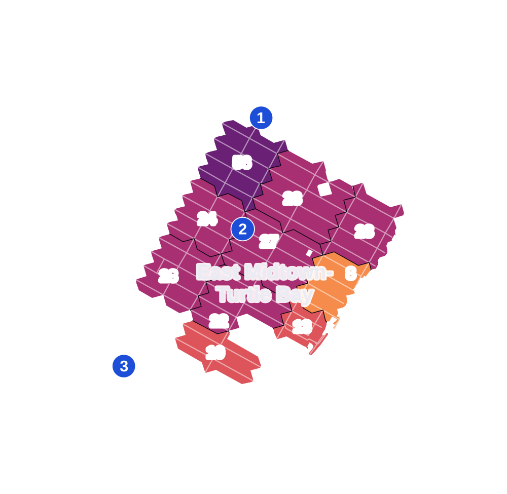
- 5 to 9
- 10 to 19
- 20 to 49
- 50 to 99
- 100 or more
- Not shaded: fewer than 5, held back under the rules in How complaints are counted, parks and public-housing grounds, and land in no patch
- Police precincts
- 17th (most of the area), 18th, 14th
From January to June 2026 the NYPD recorded 187 major felonies at places in East Midtown-Turtle Bay, against 225 in the same months of 2025.
Sources: the NYPD's Complaint Data Historic, updated April 28, 2026, and Complaint Data Current (Year To Date), updated July 27, 2026, on NYC Open Data. Figures to June 30, 2026.
Street corners
- 1st Avenue & East 45th Street
- 1st Avenue & East 46th Street
- 1st Avenue & East 49th Street
- 1st Avenue & East 50th Street
- 1st Avenue & East 51st Street
- 1st Avenue & East 52nd Street
- 1st Avenue & East 53rd Street
- 1st Avenue & East 54th Street
- 1st Avenue & East 55th Street
- 1st Avenue & East 56th Street
- 1st Avenue & East 57th Street
- 1st Avenue & East 58th Street
- 1st Avenue & Mitchell Place
- 2nd Avenue & East 45th Street
- 2nd Avenue & East 46th Street
- 2nd Avenue & East 47th Street
- 2nd Avenue & East 48th Street
- 2nd Avenue & East 49th Street
- 2nd Avenue & East 50th Street
- 2nd Avenue & East 51st Street
- 2nd Avenue & East 52nd Street
- 2nd Avenue & East 53rd Street
- 2nd Avenue & East 54th Street
- 2nd Avenue & East 55th Street
- 2nd Avenue & East 56th Street
- 2nd Avenue & East 57th Street
- 2nd Avenue & East 58th Street
- 3rd Avenue & East 44th Street
- 3rd Avenue & East 45th Street
- 3rd Avenue & East 46th Street
- 3rd Avenue & East 47th Street
- 3rd Avenue & East 48th Street
- 3rd Avenue & East 49th Street
- 3rd Avenue & East 50th Street
- 3rd Avenue & East 51st Street
- 3rd Avenue & East 52nd Street
- 3rd Avenue & East 53rd Street
- 3rd Avenue & East 54th Street
- 3rd Avenue & East 55th Street
- 3rd Avenue & East 56th Street
- 3rd Avenue & East 57th Street
- 3rd Avenue & East 58th Street
- 3rd Avenue & East 59th Street
- East 42nd Street & De Pew Place
- East 42nd Street & Vanderbilt Avenue
- East 45th Street & De Pew Place
- East 45th Street & Park Avenue Viaduct
- East 45th Street & Vanderbilt Avenue
- East 46th Street & De Pew Place
- East 50th Street & Beekman Place
- East 51st Street & Beekman Place
- East 51st Street & East 51st Street Pedestrian Overpass
- East 53rd Street & Sutton Place South
- East 54th Street & Sutton Place South
- East 55th Street & Sutton Place South
- East 56th Street & Sutton Place South
- East 57th Street & Sutton Place South
- East 58th Street & Sutton Place
- East 59th Street & Riverview Terrace
- FDR Drive & East 49th Street
- FDR Drive & East 51st Street Pedestrian Overpass
- FDR Drive & Ed Koch Queensboro Bridge Pedestrian Path
- Lexington Avenue & East 42nd Street
- Lexington Avenue & East 43rd Street
- Lexington Avenue & East 44th Street
- Lexington Avenue & East 45th Street
- Lexington Avenue & East 46th Street
- Lexington Avenue & East 47th Street
- Lexington Avenue & East 48th Street
- Lexington Avenue & East 49th Street
- Lexington Avenue & East 50th Street
- Lexington Avenue & East 51st Street
- Lexington Avenue & East 52nd Street
- Lexington Avenue & East 53rd Street
- Lexington Avenue & East 54th Street
- Lexington Avenue & East 55th Street
- Lexington Avenue & East 56th Street
- Lexington Avenue & East 57th Street
- Lexington Avenue & East 58th Street
- Mitchell Place & Beekman Place
- Park Avenue & East 42nd Street
- Park Avenue & East 46th Street
- Park Avenue & East 49th Street
- Park Avenue & East 54th Street
- Park Avenue & East 55th Street
- Park Avenue & East 56th Street
- Park Avenue & East 58th Street
- Park Avenue & East 59th Street
- Queensboro Bridge & East 57th Street
- Queensboro Bridge & East 58th Street
- Riverview Terrace & Sutton Square
How the figures above are measured: Methodology.