Murray Hill-Kips Bay
Neighborhood · Manhattan
Murray Hill-Kips Bay covers Manhattan's East Side from 23rd Street to 42nd Street, out to the East River, and includes Tudor City between First and Second Avenues.
- 0.57 square miles
- 63,520 residents, 2020 Census
- 118 street corners
- 3 subway stations
- 52 bus routes
Murray Hill is named for Robert Murray, a Scottish-born merchant whose Inclenberg estate, on land he leased before 1762, stood near today's Park Avenue and 36th Street, while Kips Bay takes its name from a former East River inlet, named for the Dutch settler Jacobus Kip, where British troops landed on September 15, 1776. Tudor City, a Tudor Revival apartment complex with its own parks, was largely finished by 1932. Bellevue Hospital and other medical centers line First Avenue.
Sources: Murray Hill, Manhattan (Wikipedia); Kips Bay, Manhattan (Wikipedia); Tudor City Historic District Designation Report (LP-1579) (NYC Landmarks Preservation Commission).
Murray Hill-Kips Bay borders six areas, and Queens Midtown Tunnel holds more of its corners than any other street, 23 of 118.
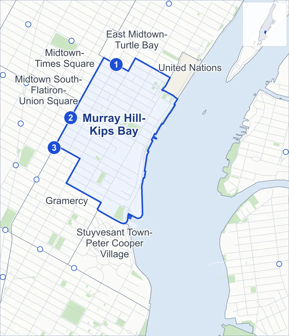
- Murray Hill-Kips Bay
- A neighboring area
- Park
- A station in the list
- Another station
Neighborhood areas and streets: NYC Department of City Planning. Parks: NYC Parks. Stations: MTA.
Neighboring areas
- East Midtown-Turtle Bay north
- United Nations northeast
- Stuyvesant Town-Peter Cooper Village south
- Gramercy southwest
- Midtown South-Flatiron-Union Square west
- Midtown-Times Square northwest
Subway stations
- Grand Central-42 St lines 4 5 6 7 accessible
- 33 St lines 6
- 28 St lines 6
Getting around
Three subway stations and buses on 52 routes stop in or at the edge of Murray Hill-Kips Bay.
- 3 subway stations
- 1 of them listed by the MTA as fully accessible
- 10 local bus routes
- 42 express bus routes
Local bus routes
- M9
- M15
- M15-SBS
- M23-SBS
- M34-SBS
- M34A-SBS
- M42
- M101
- M102
- M103
Express bus routes
- BM1
- BM2
- BM3
- BM4
- BM5
- BxM1
- QM1
- QM2
- QM4
- QM5
- QM6
- QM7
- QM8
- QM10
- QM11
- QM12
- QM15
- QM16
- QM17
- QM18
- QM20
- QM24
- QM25
- QM31
- QM32
- QM34
- QM35
- QM36
- QM40
- QM42
- QM44
- QM63
- QM64
- QM65
- QM68
- SIM3
- SIM6
- SIM10
- SIM11
- SIM31
- X37
- X38
Safety record
Between 2021 and 2025, its corners averaged more police-reported crashes than the average Manhattan corner.
- 2,126 police-reported crashes at its corners
- 18.0 a corner, on average
- 13.4 the average Manhattan corner
- 11 corners with a clean record
Signal or safety changes on City record, at 69 of its corners
- Leading pedestrian intervals
- 57
- Turn calming
- 21
- Accessible pedestrian signals
- 20
- Barnes Dance all-way crossings
- 6
Camera tickets
In 2025 its corners had more school-zone speed camera tickets than bus-lane or red-light tickets.
- 277 red-light camera tickets at one corner
- 9,891 school-zone speed camera tickets at nine corners
- 9,157 bus-lane camera tickets at three corners
- Most red-light tickets
- 3rd Avenue & East 36th Street, 277
- Most speed tickets
- 2nd Avenue & East 30th Street, 3,583
- Most bus-lane tickets
- 3rd Avenue & East 43rd Street, 8,471
People and homes
The 2020 Census counted 63,520 residents in Murray Hill-Kips Bay, about 111,400 per square mile.
- 40,838 homes, 2020 Census
- 3,414 homes added since April 2010, net, by City Planning's count
Half of its 896 residential lots hold buildings from 1912 or earlier, and 80% of them date from before 1940, by the City's tax lot records.
NYCHA development
NYCHA's Straus development lies wholly or partly within Murray Hill-Kips Bay.
Parks and landmarks
- Parkland
- 11.5 acres of NYC Parks property
- The largest pieces
- Asser Levy Playground (2.8 acres), St. Vartan Park (2.8 acres) and East River Esplanade (1.7 acres)
- Designated landmarks
- The Civic Club (Estonian House), the Daily News Building, the New York School of Applied Design for Women and the Ford Foundation Building, among others
- Historic districts
- Sniffen Court and Tudor City, wholly or partly within Murray Hill-Kips Bay
Streets and trees
- Trees
- 2,496 in NYC Parks' records, most often thornless honeylocust, maidenhair tree and Callery pear
- Street with the most corners
- Queens Midtown Tunnel, with 23 of the area's 118
- Height above sea level
- From 6 feet at FDR Drive & East 23rd Street to 77 feet at Park Avenue & East 37th Street
- Honorary street names
- 8 at its corners, enacted by local law
Schools and libraries
The City lists 13 schools and one library in Murray Hill-Kips Bay.
- Public schools
- 5
- Charter and private schools
- 8
- Library
- Kips Bay Library
Bike share and public art
By the station list of October 3, 2026, 24 bike-share stations stand in Murray Hill-Kips Bay. The City's public art inventory lists four works in the area, among them The Isaiah Wall (1948), Skagerrak (1971) and Peace Form One (1980).
- 24 bike-share stations
- 4 works of public art
Public safety
How complaints are countedIn 2025 the NYPD recorded 612 major felonies at places in Murray Hill-Kips Bay.
Recorded by the NYPD at places in Murray Hill-Kips Bay
- 473 major felonies in 2024
- 1,749 other felonies, misdemeanors and violations in 2025
In 2025, on the streets along the edge of Murray Hill-Kips Bay, the NYPD recorded another 163 major felonies. Counting the streets along its edge, in 2025 the NYPD recorded 12.2 major felonies for every thousand residents the 2020 Census counted in Murray Hill-Kips Bay.
- Police precincts
- 17th (most of the area), 13th, 14th
From January to June 2026 the NYPD recorded 262 major felonies at places in Murray Hill-Kips Bay, against 290 in the same months of 2025.
Sources: the NYPD's Complaint Data Historic, updated April 28, 2026, and Complaint Data Current (Year To Date), updated July 27, 2026, on NYC Open Data. Figures to June 30, 2026.
Street corners
- 1st Avenue & East 25th Street
- 1st Avenue & East 26th Street
- 1st Avenue & East 27th Street
- 1st Avenue & East 28th Street
- 1st Avenue & East 29th Street
- 1st Avenue & East 30th Street
- 1st Avenue & East 33rd Street
- 1st Avenue & East 34th Street
- 1st Avenue & East 35th Street
- 1st Avenue & East 36th Street
- 1st Avenue & East 37th Street
- 1st Avenue & East 38th Street
- 1st Avenue & East 39th Street
- 1st Avenue & East 40th Street
- 1st Avenue & East 42nd Street
- 2nd Avenue & East 25th Street
- 2nd Avenue & East 26th Street
- 2nd Avenue & East 27th Street
- 2nd Avenue & East 28th Street
- 2nd Avenue & East 29th Street
- 2nd Avenue & East 30th Street
- 2nd Avenue & East 31st Street
- 2nd Avenue & East 32nd Street
- 2nd Avenue & East 33rd Street
- 2nd Avenue & East 34th Street
- 2nd Avenue & East 35th Street
- 2nd Avenue & East 36th Street
- 2nd Avenue & East 37th Street
- 2nd Avenue & East 38th Street
- 2nd Avenue & East 39th Street
- 2nd Avenue & East 40th Street
- 2nd Avenue & East 41st Street
- 2nd Avenue & East 42nd Street
- 2nd Avenue & East 43rd Street
- 2nd Avenue & East 44th Street
- 2nd Avenue & Queens Midtown Tunnel
- 3rd Avenue & East 27th Street
- 3rd Avenue & East 28th Street
- 3rd Avenue & East 29th Street
- 3rd Avenue & East 30th Street
- 3rd Avenue & East 31st Street
- 3rd Avenue & East 32nd Street
- 3rd Avenue & East 33rd Street
- 3rd Avenue & East 34th Street
- 3rd Avenue & East 35th Street
- 3rd Avenue & East 36th Street
- 3rd Avenue & East 37th Street
- 3rd Avenue & East 38th Street
- 3rd Avenue & East 39th Street
- 3rd Avenue & East 40th Street
- 3rd Avenue & East 41st Street
- 3rd Avenue & East 42nd Street
- 3rd Avenue & East 43rd Street
- Avenue C & East 23rd Street
- East 25th Street & Avenue C
- East 25th Street & East 25th Street Pedestrian Overpass
- East 26th Street & Mount Carmel Place
- East 27th Street & Mount Carmel Place
- East 28th Street & Mount Carmel Place
- East 30th Street & Park Avenue South
- East 34th Street & Queens Midtown Tunnel (north-west)
- East 34th Street & Queens Midtown Tunnel (south-east)
- East 35th Street & Queens Midtown Tunnel (north-west)
- East 35th Street & Queens Midtown Tunnel (south-east)
- East 36th Street & Queens Midtown Tunnel
- East 36th Street & Sniffen Court
- East 37th Street & East River Esplanade
- East 37th Street & FDR Drive
- East 37th Street & Queens Midtown Tunnel (north-west)
- East 37th Street & Queens Midtown Tunnel (south-east)
- East 38th Street & Queens Midtown Tunnel (north-west)
- East 38th Street & Queens Midtown Tunnel (south-east)
- East 39th Street & Queens Midtown Tunnel (north-west)
- East 39th Street & Queens Midtown Tunnel (south-east)
- East 40th Street & Queens Midtown Tunnel (north-west)
- East 40th Street & Queens Midtown Tunnel (south-east)
- East 41st Street & Queens Midtown Tunnel
- East 41st Street & Tudor City Place
- East 43rd Street & Tudor City Place
- East River Esplanade & East 25th Street Pedestrian Overpass
- FDR Drive & Avenue C
- FDR Drive & Connector
- FDR Drive & East 23rd Street
- FDR Drive & East 27th Street
- FDR Drive & East 28th Street
- FDR Drive & East 30th Street
- FDR Drive & East 34th Street
- FDR Drive & East 34th Street (East 34th Street)
- FDR Drive & East 35th Street
- FDR Drive & East 36th Street
- FDR Drive & East 37th Street
- FDR Drive & East 38th Street
- FDR Drive & East 41st Street
- FDR Drive & Queens Midtown Tunnel
- FDR Drive & Queens Midtown Tunnel (Exit 9)
- Lexington Avenue & East 29th Street
- Lexington Avenue & East 30th Street
- Lexington Avenue & East 31st Street
- Lexington Avenue & East 32nd Street
- Lexington Avenue & East 33rd Street
- Lexington Avenue & East 34th Street
- Lexington Avenue & East 35th Street
- Lexington Avenue & East 36th Street
- Lexington Avenue & East 37th Street
- Lexington Avenue & East 38th Street
- Lexington Avenue & East 39th Street
- Lexington Avenue & East 40th Street
- Lexington Avenue & East 41st Street
- Park Avenue & East 33rd Street
- Park Avenue & East 34th Street
- Park Avenue & East 35th Street
- Park Avenue & East 36th Street
- Park Avenue & East 37th Street
- Queens Midtown Tunnel & 1st Avenue
- Queens Midtown Tunnel & East 37th Street (north-west)
- Queens Midtown Tunnel & East 37th Street (south-east)
- Queens Midtown Tunnel & East 38th Street
- Queens Midtown Tunnel & East 41st Street
How the figures above are measured: Methodology.