Stuyvesant Town-Peter Cooper Village
Neighborhood · Manhattan
Two apartment complexes share the 80-acre tract of Stuyvesant Town-Peter Cooper Village, between 14th and 23rd Streets from First Avenue to Avenue C. The Metropolitan Life Insurance Company began planning them in 1942 on the site of the old Gas House District, and the first building opened in 1947.
- 0.20 square miles
- 22,512 residents, 2020 Census
- 13 street corners
- 1 subway station
- 23 bus routes
Their red brick towers, holding 11,250 apartments, are set in two large superblocks, each with a large park. Stuyvesant Town, south of 20th Street, is named for Peter Stuyvesant, New Amsterdam's last Dutch director-general, whose farm once covered the site, and Peter Cooper Village for the inventor and industrialist who founded the Cooper Union in 1859.
Sources: Stuyvesant Town–Peter Cooper Village (Wikipedia); History (The Cooper Union).
Stuyvesant Town-Peter Cooper Village borders three areas, and Stuyvesant Oval holds more of its corners than any other street, five of 13.
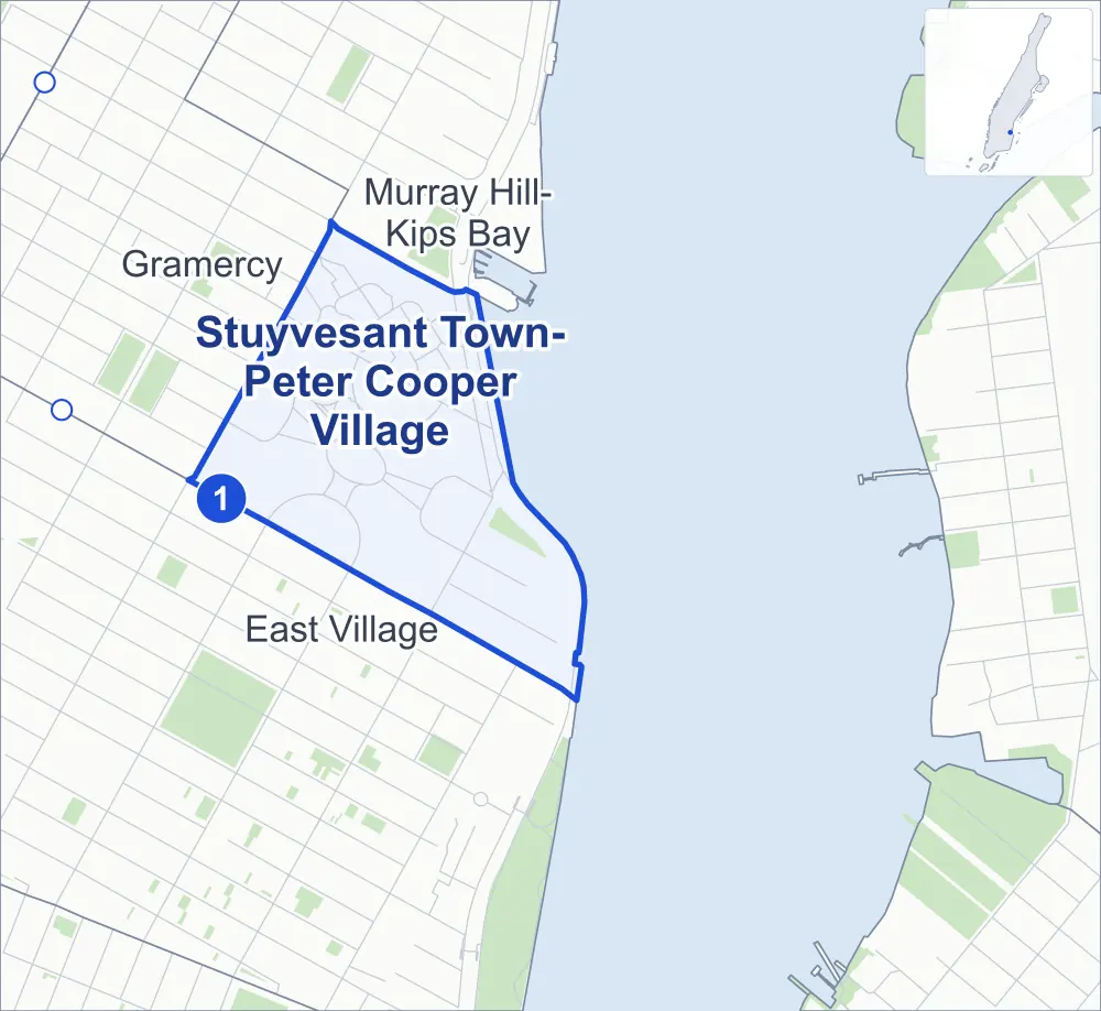
- Stuyvesant Town-Peter Cooper Village
- A neighboring area
- Park
- A station in the list
- Another station
Neighborhood areas and streets: NYC Department of City Planning. Parks: NYC Parks. Stations: MTA.
Neighboring areas
- Murray Hill-Kips Bay north
- East Village south
- Gramercy northwest
Subway stations
- 1 Av lines L accessible
Getting around
One subway station and buses on 23 routes stop in or at the edge of Stuyvesant Town-Peter Cooper Village.
- 1 subway station
- 1 listed by the MTA as fully accessible
- 9 local bus routes
- 14 express bus routes
Local bus routes
- L92
- M9
- M14A-SBS
- M14D-SBS
- M15
- M15-SBS
- M23-SBS
- M34-SBS
- M34A-SBS
Express bus routes
- BM1
- BM2
- BM3
- BM4
- QM63
- QM64
- QM68
- SIM3
- SIM6
- SIM10
- SIM11
- SIM31
- X37
- X38
Safety record
Between 2021 and 2025, its corners averaged fewer police-reported crashes than the average Manhattan corner.
- 101 police-reported crashes at its corners
- 7.8 a corner, on average
- 13.4 the average Manhattan corner
- 4 corners with a clean record
Signal or safety changes on City record, at six of its corners
- Accessible pedestrian signals
- 6
- Leading pedestrian intervals
- 4
- Turn calming
- 1
- Barnes Dance all-way crossings
- 1
- Safety Improvement Projects
- 1
Camera tickets
In 2025 its corners had more bus-lane camera tickets than school-zone speed or red-light tickets.
- 42 red-light camera tickets at one corner
- 280 school-zone speed camera tickets at one corner
- 698 bus-lane camera tickets at one corner
- Most red-light tickets
- 1st Avenue & East 23rd Street, 42
- Most speed tickets
- East 20th Street & 20th Street Loop, 280
- Most bus-lane tickets
- 1st Avenue & East 23rd Street, 698
People and homes
The 2020 Census counted 22,512 residents in Stuyvesant Town-Peter Cooper Village, about 112,600 per square mile.
- 11,291 homes, 2020 Census
- 34 homes added since April 2010, net, by City Planning's count
Parks
- Parkland
- 1.4 acres of NYC Parks property
- The largest piece
- Murphy Brothers Playground (1.2 acres)
Streets and trees
- Trees
- 483 in NYC Parks' records, most often thornless honeylocust, London planetree and swamp white oak
- Street with the most corners
- Stuyvesant Oval, with five of the area's 13
- Height above sea level
- From 6 feet at Avenue C & East 16th Street to 17 feet at East 14th Street & Avenue A
Bike share
By the station list of October 3, 2026, six bike-share stations stand in Stuyvesant Town-Peter Cooper Village.
- 6 bike-share stations
Public safety
How complaints are countedIn 2025 the NYPD recorded 57 major felonies at places in Stuyvesant Town-Peter Cooper Village.
Recorded by the NYPD at places in Stuyvesant Town-Peter Cooper Village
- 62 major felonies in 2024
- 167 other felonies, misdemeanors and violations in 2025
In 2025, on the streets along the edge of Stuyvesant Town-Peter Cooper Village, the NYPD recorded another 149 major felonies.
- Police precinct
- 13th
From January to June 2026 the NYPD recorded 20 major felonies at places in Stuyvesant Town-Peter Cooper Village, against 24 in the same months of 2025.
Sources: the NYPD's Complaint Data Historic, updated April 28, 2026, and Complaint Data Current (Year To Date), updated July 27, 2026, on NYC Open Data. Figures to June 30, 2026.
Street corners
- 1st Avenue & East 23rd Street
- 1st Avenue Loop & Stuyvesant Oval
- 14th Street Loop & Stuyvesant Oval
- 20th Street Loop & Stuyvesant Oval (north-west)
- 20th Street Loop & Stuyvesant Oval (south-east)
- Avenue C & Avenue C Loop
- Avenue C & East 16th Street
- Avenue C & East 20th Street
- Avenue C Loop & Stuyvesant Oval
- East 14th Street & Avenue A
- East 20th Street & 20th Street Loop (north-west)
- East 20th Street & 20th Street Loop (south-east)
- East 23rd Street & East River Esplanade
How the figures above are measured: Methodology.