Central Park
Park · Manhattan
Central Park stretches through the middle of Manhattan from 59th Street to 110th Street, between Fifth Avenue and Central Park West.
- 1.37 square miles
- 61 street corners
- 8 subway stations
- 33 bus routes
Frederick Law Olmsted and Calvert Vaux won the 1858 design competition with their Greensward plan, and construction ran until 1873, making it the nation's first large-scale public park designed and built to a plan. Its 843 acres hold meadows, woodlands, lakes, the elm-lined Mall and Bethesda Terrace, and the City designated it a Scenic Landmark in 1974. Since 1980 the nonprofit Central Park Conservancy has managed the park in partnership with the City.
Sources: Central Park Designation Report (LP-0851, April 16, 1974) (NYC Landmarks Preservation Commission); Park History (Central Park Conservancy); Central Park (The Cultural Landscape Foundation); Central Park (UNESCO World Heritage Centre).
Central Park borders seven areas, and West Drive holds more of its corners than any other street, 23 of 61.
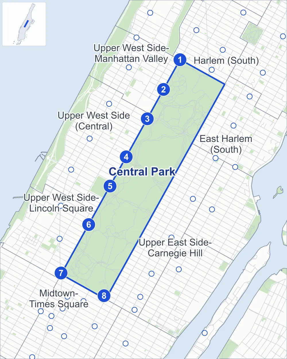
- Central Park
- A neighboring area
- Park
- A station in the list
- Another station
Neighborhood areas and streets: NYC Department of City Planning. Parks: NYC Parks. Stations: MTA.
Neighboring areas
- Upper West Side-Manhattan Valley north
- East Harlem (South) northeast
- Harlem (South) northeast
- Upper East Side-Carnegie Hill south
- Upper West Side-Lincoln Square southwest
- Midtown-Times Square southwest
- Upper West Side (Central) northwest
Subway stations
- Cathedral Pkwy (110 St) lines B C
- 103 St lines B C
- 96 St lines B C
- 86 St lines B C
- 81 St-Museum of Natural History lines B C
- 72 St lines B C
- 59 St-Columbus Circle lines 1 A B C D accessible
- 5 Av/59 St lines N R W
Getting around
Eight subway stations and buses on 33 routes stop in or at the edge of Central Park.
- 8 subway stations
- 1 of them listed by the MTA as fully accessible
- 15 local bus routes
- 18 express bus routes
Local bus routes
- M1
- M2
- M3
- M4
- M5
- M7
- M10
- M20
- M66
- M72
- M79-SBS
- M86-SBS
- M96
- M104
- M106
Express bus routes
- BxM2
- BxM3
- BxM4
- BxM6
- BxM7
- BxM8
- BxM9
- BxM10
- BxM11
- SIM1C
- SIM3
- SIM3C
- SIM4C
- SIM10
- SIM23
- SIM24
- SIM30
- SIM33C
Safety record
Between 2021 and 2025, its corners averaged fewer police-reported crashes than the average Manhattan corner.
- 16 police-reported crashes at its corners
- 0.3 a corner, on average
- 13.4 the average Manhattan corner
- 57 corners with a clean record
Signal or safety changes on City record, at five of its corners
- Accessible pedestrian signals
- 3
- Barnes Dance all-way crossings
- 2
Camera tickets
In 2025 the Department of Finance recorded no red-light, school-zone speed or bus-lane camera ticket at its corners.
Parks and landmarks
- Parkland
- 838.7 acres of Central Park, as NYC Parks maps it within the area's boundary
- Designated landmarks
- The Metropolitan Museum of Art and the Arsenal
Streets and trees
- Trees
- 1,082 in NYC Parks' records, most often American elm, pin oak and maidenhair tree
- Street with the most corners
- West Drive, with 23 of the area's 61
- Height above sea level
- From 27 feet at East Drive & Central Park Lenox Avenue Access Road to 117 feet at West Drive & Central Park Entrance West 90th Street
Bike share and public art
By the station list of October 3, 2026, 11 bike-share stations stand in Central Park. The City's public art inventory lists 68 works in the area, among them Johann Christoph Friedrich Von Schiller (1859), Eagles and Prey (1863) and Tigress and Cubs (1867).
- 11 bike-share stations
- 68 works of public art
Public safety
How complaints are countedCentral Park and the 22nd Precinct share one boundary, so the park's figures are counted from the complaints the NYPD gives to that precinct. In 2025 the NYPD recorded 85 major felonies in Central Park.
Recorded by the NYPD in Central Park
- 99 major felonies in 2024
- 221 other felonies, misdemeanors and violations in 2025
From January to June 2026 the NYPD recorded 35 major felonies in Central Park, against 30 in the same months of 2025.
Sources: the NYPD's Complaint Data Historic, updated April 28, 2026, and Complaint Data Current (Year To Date), updated July 27, 2026, on NYC Open Data. Figures to June 30, 2026.
Street corners
- 79th Street Transverse & Central Park Path
- 86th Street Transverse & Bridle Path
- 97th Street Transverse & Central Park Entrance West 96th Street
- 102nd Street Crossing & North Meadow Path
- Bethesda Terrace Underpass & Bethesda Terrace Path
- Bridle Path West & Heckscher Ballfields Path (north)
- Bridle Path West & Heckscher Ballfields Path (south)
- Center Drive & 65th Street Transverse
- Center Drive & Central Park Path
- Center Drive & Heckscher Ballfields Path
- Center Drive & Terrace Drive
- Center Drive & Terrace Drive at Cherry Hill Path
- Center Drive & The Mall
- Central Park Entrance East 102nd Street & East Meadow Path
- Central Park Exit West 67th Street & Bridle Path West
- Central Park Exit West 100th Street & Central Park Pool Path
- Central Park Great Hill & Central Park Entrance West 106th Street
- Central Park Great Hill & Central Park Pool Path (north-west)
- Central Park Great Hill & Central Park Pool Path (south-east)
- Central Park Path & Hallett Nature Sanctuary Path
- East Drive & 86th Street Transverse
- East Drive & 102nd Street Crossing
- East Drive & Center Drive
- East Drive & Central Park Entrance East 102nd Street
- East Drive & Central Park Exit Powell Boulevard
- East Drive & Central Park Lenox Avenue Access Road
- East Drive & Central Park Path
- East Drive & Conservatory Garden Path (north)
- East Drive & Conservatory Garden Path (south)
- East Drive & East 90th Street
- East Drive & East Meadow Path (north-east)
- East Drive & East Meadow Path (south-west)
- East Drive & Grand Army Plaza
- East Drive & Hallett Nature Sanctuary Path
- Frederick Douglass Circle & Central Park Entrance West 110th Street
- Heckscher Ballfields Path & Central Park Path
- Terrace Drive & Cherry Hill Path
- The Mall & Bethesda Terrace Underpass
- West Drive & 65th Street Transverse
- West Drive & 102nd Street Crossing
- West Drive & Bridle Path West
- West Drive & Center Drive
- West Drive & Central Park Bow Bridge Path
- West Drive & Central Park Entrance 8th Avenue at Heckscher Ballfields Path (north-west)
- West Drive & Central Park Entrance 8th Avenue at Heckscher Ballfields Path (south-east)
- West Drive & Central Park Entrance Powell Boulevard
- West Drive & Central Park Entrance West 77th Street
- West Drive & Central Park Entrance West 85th Street
- West Drive & Central Park Entrance West 90th Street
- West Drive & Central Park Entrance West 96th Street
- West Drive & Central Park Entrance West 106th Street
- West Drive & Central Park Entrance West 110th Street
- West Drive & Central Park Exit West 67th Street
- West Drive & Central Park Exit West 72nd Street
- West Drive & Central Park Exit West 100th Street
- West Drive & Central Park Pool Path
- West Drive & Heckscher Ballfields Path (north-east)
- West Drive & Heckscher Ballfields Path (south-west)
- West Drive & North Meadow Path (north-east)
- West Drive & North Meadow Path (south-west)
- West Drive & Terrace Drive
How the figures above are measured: Methodology.