Hell's Kitchen
Neighborhood · Manhattan
West of Eighth Avenue, Hell's Kitchen runs up Manhattan's West Side to 59th Street along the Hudson River, with the Theater District and Times Square to the east.
- 0.66 square miles
- 59,524 residents, 2020 Census
- 93 street corners
- 2 subway stations
- 18 bus routes
Accounts of how it got its name vary, and since 1959 the city has also called it Clinton, after DeWitt Clinton Park at Eleventh Avenue and 52nd Street. Irish immigrants once found work on the Hudson River docks and railroad here, and today Ninth Avenue is known for its many restaurants and an international food festival held since 1974. At Pier 86, the aircraft carrier Intrepid, commissioned in 1943, is a museum that also displays the space shuttle Enterprise.
Sources: Hell's Kitchen, Manhattan (Wikipedia); Intrepid Museum.
Hell's Kitchen borders three areas, and 9th Avenue holds more of its corners than any other street, 20 of 93.
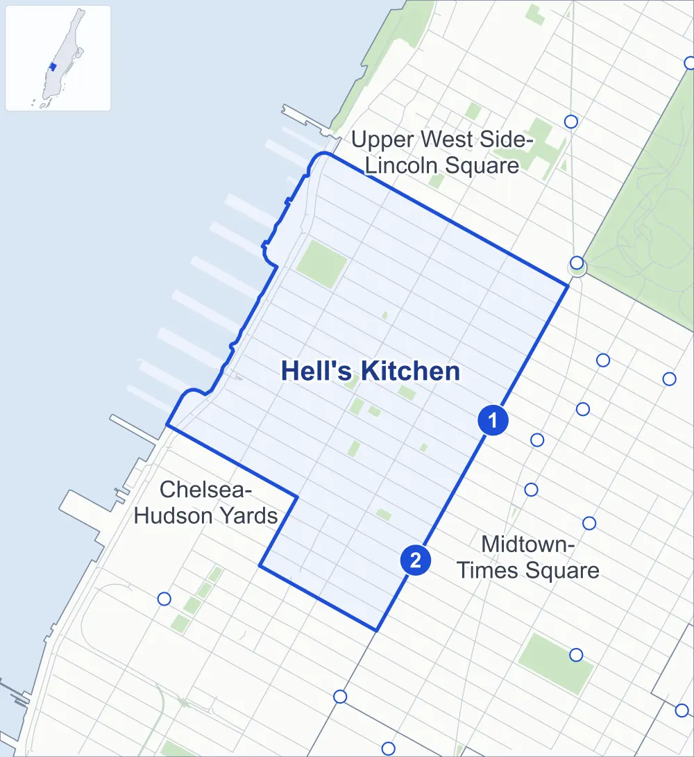
- Hell's Kitchen
- A neighboring area
- Park
- A station in the list
- Another station
Neighborhood areas and streets: NYC Department of City Planning. Parks: NYC Parks. Stations: MTA.
Neighboring areas
- Upper West Side-Lincoln Square northeast
- Midtown-Times Square southeast
- Chelsea-Hudson Yards southwest
Subway stations
- 50 St lines C E
- 42 St-Port Authority Bus Terminal lines A C E accessible
Getting around
Two subway stations and buses on 18 routes stop in or at the edge of Hell's Kitchen.
- 2 subway stations
- 1 of them listed by the MTA as fully accessible
- 13 local bus routes
- 5 express bus routes
Local bus routes
- M5
- M7
- M10
- M11
- M12
- M20
- M31
- M34A-SBS
- M42
- M50
- M57
- M104
- T260
Express bus routes
- SIM8
- SIM22
- SIM25
- SIM26
- SIM30
Safety record
Between 2021 and 2025, its corners averaged more police-reported crashes than the average Manhattan corner.
- 2,258 police-reported crashes at its corners
- 24.3 a corner, on average
- 13.4 the average Manhattan corner
- 7 corners with a clean record
Signal or safety changes on City record, at 71 of its corners
- Leading pedestrian intervals
- 65
- Accessible pedestrian signals
- 25
- Turn calming
- 10
- Safety Improvement Projects
- 6
Camera tickets
In 2025 its corners had more school-zone speed camera tickets than bus-lane or red-light tickets.
- 0 red-light camera tickets
- 20,426 school-zone speed camera tickets at six corners
- 140 bus-lane camera tickets at one corner
- Most speed tickets
- 10th Avenue & West 57th Street, 14,328
- Most bus-lane tickets
- 8th Avenue & West 42nd Street, 140
People and homes
The 2020 Census counted 59,524 residents in Hell's Kitchen, about 90,200 per square mile.
- 39,047 homes, 2020 Census
- 9,767 homes added since April 2010, net, by City Planning's count
Half of its 1,072 residential lots hold buildings from 1920 or earlier, and 84% of them date from before 1940, by the City's tax lot records.
NYCHA development
One NYCHA development, which NYCHA names by a building's address, lies wholly or partly within Hell's Kitchen.
Parks and landmarks
- Parkland
- 8.6 acres of NYC Parks property
- The largest pieces
- De Witt Clinton Park (5.8 acres), Gutenberg Playground (0.6 acre) and Hell's Kitchen Park (0.6 acre)
- Designated landmarks
- The Actors Studio; the McGraw-Hill Building; the Eleventh District Municipal Court; and the Martin Beck Theater, now the Al Hirschfeld Theater, among others
Streets and trees
- Trees
- 2,675 in NYC Parks' records, most often thornless honeylocust, maidenhair tree and Callery pear
- Street with the most corners
- 9th Avenue, with 20 of the area's 93
- Height above sea level
- From 12 feet at 11th Avenue & West 43rd Street to 85 feet at 9th Avenue & West 57th Street
- Honorary street names
- 2 at its corners, enacted by local law
Schools and libraries
The City lists 22 schools and one library in Hell's Kitchen.
- Public schools
- 17
- Charter and private schools
- 5
- Library
- Columbus Library
Bike share and public art
By the station list of October 3, 2026, 21 bike-share stations stand in Hell's Kitchen. The City's public art inventory lists three works in the area: Clinton War Memorial (1929), Private Passage (2005) and Wall Drawing #1252: Scribbles for Pier 88 (2008).
- 21 bike-share stations
- 3 works of public art
Public safety
How complaints are countedIn 2025 the NYPD recorded 1,031 major felonies at places in Hell's Kitchen.
Recorded by the NYPD at places in Hell's Kitchen
- 970 major felonies in 2024
- 3,097 other felonies, misdemeanors and violations in 2025
In 2025, on the streets along the edge of Hell's Kitchen, the NYPD recorded another 361 major felonies. Counting the streets along its edge, in 2025 the NYPD recorded 23.4 major felonies for every thousand residents the 2020 Census counted in Hell's Kitchen.
- Police precincts
- 18th (most of the area), 14th, 10th
From January to June 2026 the NYPD recorded 394 major felonies at places in Hell's Kitchen, against 537 in the same months of 2025.
Sources: the NYPD's Complaint Data Historic, updated April 28, 2026, and Complaint Data Current (Year To Date), updated July 27, 2026, on NYC Open Data. Figures to June 30, 2026.
Street corners
- 8th Avenue & West 38th Street
- 8th Avenue & West 39th Street
- 8th Avenue & West 40th Street
- 8th Avenue & West 41st Street
- 8th Avenue & West 42nd Street
- 8th Avenue & West 43rd Street
- 8th Avenue & West 44th Street
- 8th Avenue & West 45th Street
- 8th Avenue & West 50th Street
- 8th Avenue & West 51st Street
- 8th Avenue & West 52nd Street
- 8th Avenue & West 53rd Street
- 8th Avenue & West 55th Street
- 8th Avenue & West 58th Street
- 9th Avenue & West 38th Street
- 9th Avenue & West 39th Street
- 9th Avenue & West 40th Street
- 9th Avenue & West 41st Street
- 9th Avenue & West 42nd Street
- 9th Avenue & West 43rd Street
- 9th Avenue & West 44th Street
- 9th Avenue & West 45th Street
- 9th Avenue & West 46th Street
- 9th Avenue & West 47th Street
- 9th Avenue & West 48th Street
- 9th Avenue & West 49th Street
- 9th Avenue & West 50th Street
- 9th Avenue & West 51st Street
- 9th Avenue & West 52nd Street
- 9th Avenue & West 53rd Street
- 9th Avenue & West 54th Street
- 9th Avenue & West 55th Street
- 9th Avenue & West 56th Street
- 9th Avenue & West 57th Street
- 10th Avenue & West 39th Street
- 10th Avenue & West 40th Street
- 10th Avenue & West 42nd Street
- 10th Avenue & West 43rd Street
- 10th Avenue & West 44th Street
- 10th Avenue & West 45th Street
- 10th Avenue & West 46th Street
- 10th Avenue & West 47th Street
- 10th Avenue & West 48th Street
- 10th Avenue & West 49th Street
- 10th Avenue & West 50th Street
- 10th Avenue & West 51st Street
- 10th Avenue & West 52nd Street
- 10th Avenue & West 53rd Street
- 10th Avenue & West 54th Street
- 10th Avenue & West 55th Street
- 10th Avenue & West 56th Street
- 10th Avenue & West 57th Street
- 11th Avenue & West 42nd Street
- 11th Avenue & West 43rd Street
- 11th Avenue & West 44th Street
- 11th Avenue & West 45th Street
- 11th Avenue & West 46th Street
- 11th Avenue & West 47th Street
- 11th Avenue & West 48th Street
- 11th Avenue & West 49th Street
- 11th Avenue & West 50th Street
- 11th Avenue & West 51st Street
- 11th Avenue & West 52nd Street
- 11th Avenue & West 53rd Street
- 11th Avenue & West 54th Street
- 11th Avenue & West 55th Street
- 11th Avenue & West 56th Street
- 11th Avenue & West 57th Street
- 12th Avenue & West Side Highway at West 43rd Street
- 12th Avenue & West Side Highway at West 44th Street
- 12th Avenue & West Side Highway at West 46th Street
- 12th Avenue & West Side Highway at West 46th Street Pedestrian Overpass
- 12th Avenue & West Side Highway at West 48th Street
- 12th Avenue & West Side Highway at West 49th Street
- 12th Avenue & West Side Highway at West 50th Street
- 12th Avenue & West Side Highway at West 51st Street
- 12th Avenue & West Side Highway at West 52nd Street
- 12th Avenue & West Side Highway at West 54th Street
- 12th Avenue & West Side Highway at West 55th Street
- 12th Avenue & West Side Highway at West 56th Street
- 12th Avenue & West Side Highway at West 59th Street
- Dyer Avenue & Path Bus Terminal
- Lincoln Tunnel & Dyer Avenue
- Lincoln Tunnel & Lincoln Tunnel Bus
- Pedestrian Overpass & West 46th Street Pedestrian Overpass
- Port Authority Bus Terminal & Dyer Avenue
- West 38th Street & Lincoln Tunnel
- West 39th Street & Path Bus Terminal
- West 40th Street & Dyer Avenue
- West 40th Street & Path Bus Terminal
- West 41st Street & Dyer Avenue
- West 42nd Street & Dyer Avenue
- West 46th Street & Pedestrian Overpass
How the figures above are measured: Methodology.