West Village
Neighborhood · Manhattan
The West Village, the western part of Greenwich Village between the Hudson River and 14th Street, includes the Meatpacking District, where the High Line starts at Gansevoort Street and the Whitney Museum of American Art moved in 2015.
- 0.52 square miles
- 35,011 residents, 2020 Census
- 162 street corners
- 5 subway stations
- 22 bus routes
Many of its streets were laid out in the 18th century, before the Commissioners' Plan of 1811, so they sit at an angle to the grid, and West 4th Street crosses West 10th, 11th and 12th Streets. The Stonewall uprising of June 28, 1969, a milestone for LGBTQ civil rights, is remembered at Christopher Park in the Stonewall National Monument. Historic districts here were designated in 1969, 2003 and 2006.
Sources: West Village (Wikipedia); Stonewall National Monument (National Park Service); History (Friends of the High Line).
West Village borders three areas, and Washington Street holds more of its corners than any other street, 20 of 162.
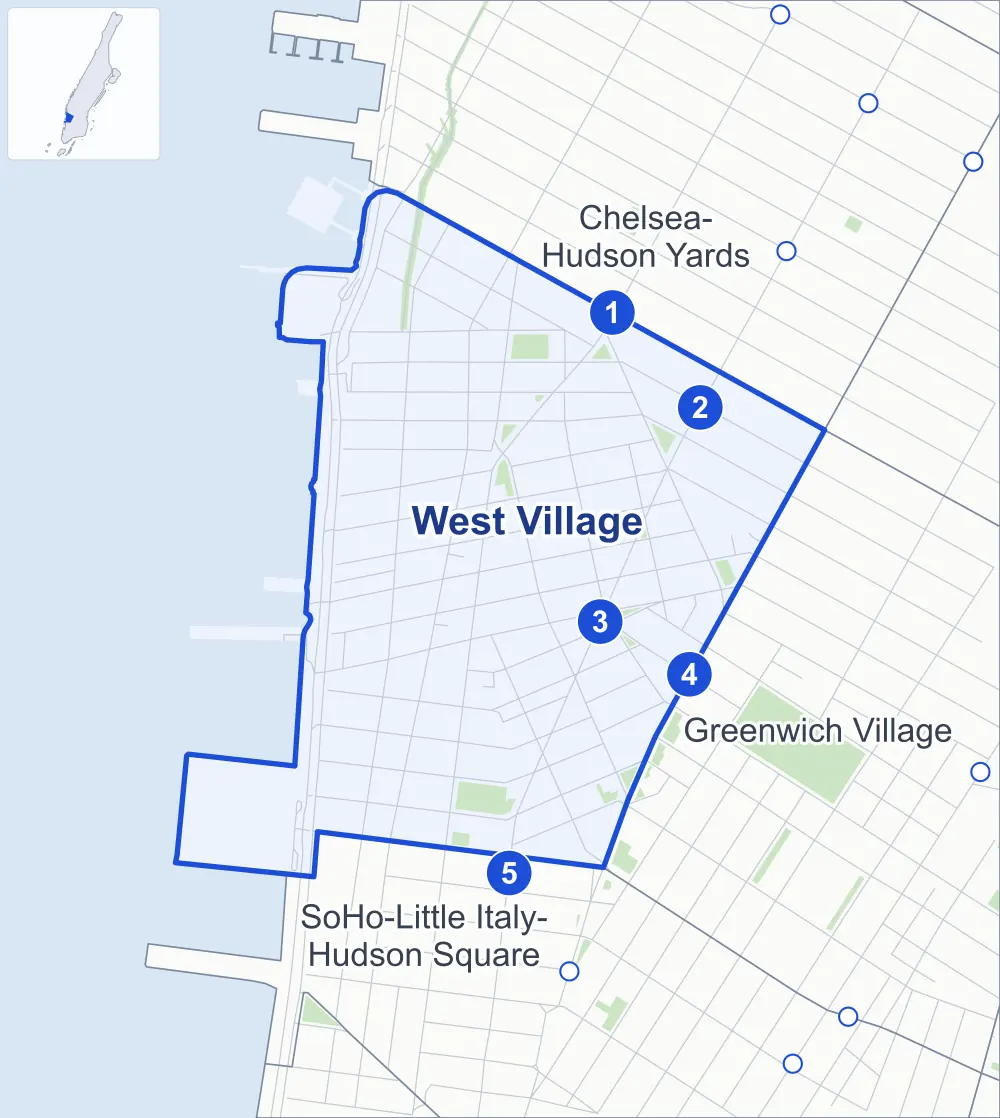
- West Village
- A neighboring area
- Park
- A station in the list
- Another station
Neighborhood areas and streets: NYC Department of City Planning. Parks: NYC Parks. Stations: MTA.
Neighboring areas
- Chelsea-Hudson Yards northeast
- Greenwich Village southeast
- SoHo-Little Italy-Hudson Square south
Subway stations
- 8 Av lines L accessible
- 14 St / 6 Av lines 1 2 3 L accessible
- Christopher St-Stonewall lines 1
- W 4 St-Wash Sq lines A B C D E F M accessible
- Houston St lines 1
Getting around
Five subway stations and buses on 22 routes stop in or at the edge of West Village.
- 5 subway stations
- 3 of them listed by the MTA as fully accessible
- 11 local bus routes
- 11 express bus routes
Local bus routes
- L92
- M7
- M8
- M11
- M12
- M14A-SBS
- M14D-SBS
- M20
- M21
- M55
- T232
Express bus routes
- SIM1
- SIM1C
- SIM3C
- SIM4C
- SIM7
- SIM9
- SIM33
- SIM33C
- SIM34
- X27
- X28
Safety record
Between 2021 and 2025, its corners averaged fewer police-reported crashes than the average Manhattan corner.
- 1,166 police-reported crashes at its corners
- 7.2 a corner, on average
- 13.4 the average Manhattan corner
- 12 corners with a clean record
Signal or safety changes on City record, at 45 of its corners
- Leading pedestrian intervals
- 26
- Accessible pedestrian signals
- 22
- Barnes Dance all-way crossings
- 6
- Enhanced crossings
- 4
- Turn calming
- 3
- Safety Improvement Projects
- 3
Camera tickets
In 2025 its corners had more school-zone speed camera tickets than red-light or bus-lane tickets.
- 4,177 red-light camera tickets at one corner
- 20,974 school-zone speed camera tickets at four corners
- 707 bus-lane camera tickets at two corners
- Most red-light tickets
- West Street & West Houston Street, 4,177
- Most speed tickets
- West Street & Leroy Street, 17,918
- Most bus-lane tickets
- 8th Avenue & West 14th Street, 618
People and homes
The 2020 Census counted 35,011 residents in West Village, about 67,300 per square mile.
- 23,750 homes, 2020 Census
- 245 homes added since April 2010, net, by City Planning's count
Half of its 1,769 residential lots hold buildings from 1866 or earlier, and 93% of them date from before 1940, by the City's tax lot records.
Parks and landmarks
- Parkland
- 6.5 acres of NYC Parks property
- The largest pieces
- James J Walker Park (1.7 acres), the High Line (1.2 acres) and Corporal John A. Seravalli Playground (1.1 acres)
- Designated landmarks
- The F. W. Devoe & Co. Factory, the Manufacturers Hanover Trust Company Building, the American Seamen's Friend Society Sailors' Home and Institute and the Bell Telephone Laboratories Complex, among others
- Historic districts
- Gansevoort Market, Greenwich Village, Greenwich Village Extension and Weehawken Street, wholly or partly within West Village
Streets and trees
- Trees
- 2,917 in NYC Parks' records, most often thornless honeylocust, maidenhair tree and Callery pear
- Street with the most corners
- Washington Street, with 20 of the area's 162
- Height above sea level
- From 6 feet at 10th Avenue & Gansevoort Street to 28 feet at West 4th Street & Perry Street
- Honorary street names
- 11 at its corners, enacted by local law
Schools and libraries
The City lists 11 schools and two libraries in West Village.
- Public schools
- 5
- Charter and private schools
- 6
- Libraries
- Hudson Park Library and Jefferson Market Library
Bike share and public art
By the station list of October 3, 2026, 20 bike-share stations stand in West Village. The City's public art inventory lists seven works in the area, among them Firemen's Memorial (1834), Abingdon Square Doughboy (1921) and General Philip Henry Sheridan (1936).
- 20 bike-share stations
- 7 works of public art
Public safety
How complaints are countedIn 2025 the NYPD recorded 691 major felonies at places in the West Village.
Recorded by the NYPD at places in the West Village
- 814 major felonies in 2024 123 fewer in 2025
- 1,255 other felonies, misdemeanors and violations in 2025
In 2025, on the streets along the edge of the West Village, the NYPD recorded another 228 major felonies. Counting the streets along its edge, in 2025 the NYPD recorded 26.2 major felonies for every thousand residents the 2020 Census counted in the West Village.
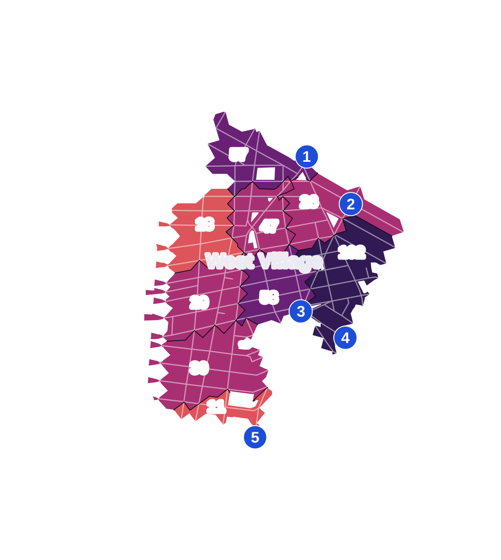
- 5 to 9
- 10 to 19
- 20 to 49
- 50 to 99
- 100 or more
- Not shaded: fewer than 5, held back under the rules in How complaints are counted, parks and public-housing grounds, and land in no patch
- Police precinct
- 6th
From January to June 2026 the NYPD recorded 303 major felonies at places in the West Village, against 289 in the same months of 2025.
Sources: the NYPD's Complaint Data Historic, updated April 28, 2026, and Complaint Data Current (Year To Date), updated July 27, 2026, on NYC Open Data. Figures to June 30, 2026.
Street corners
- 7th Avenue & West 11th Street
- 7th Avenue & West 12th Street
- 7th Avenue & West 13th Street
- 7th Avenue South & Barrow Street
- 7th Avenue South & Bedford Street
- 7th Avenue South & Charles Street
- 7th Avenue South & Commerce Street
- 7th Avenue South & Grove Street
- 7th Avenue South & Leroy Street
- 7th Avenue South & Perry Street
- 8th Avenue & Greenwich Avenue
- 8th Avenue & Horatio Street
- 8th Avenue & Hudson Street
- 8th Avenue & Jane Street
- 8th Avenue & West 4th Street
- 8th Avenue & West 12th Street
- 8th Avenue & West 13th Street
- 8th Avenue & West 14th Street
- 9th Avenue & Greenwich Street
- 9th Avenue & Hudson Street
- 9th Avenue & Little West 12th Street
- 9th Avenue & West 13th Street
- 10th Avenue & Gansevoort Street
- 10th Avenue & Little West 12th Street
- 10th Avenue & West 13th Street
- 10th Avenue & West 14th Street
- Avenue of the Americas & Bleecker Street
- Avenue of the Americas & Carmine Street
- Avenue of the Americas & Milligan Place
- Avenue of the Americas & Washington Place
- Avenue of the Americas & Waverly Place
- Avenue of the Americas & West 4th Street
- Avenue of the Americas & West 13th Street
- Barrow Street & Bedford Street
- Barrow Street & Commerce Street
- Bedford Street & Carmine Street
- Bedford Street & Commerce Street
- Bedford Street & Downing Street
- Bedford Street & Grove Street
- Bedford Street & Leroy Street
- Bleecker Street & 7th Avenue South
- Bleecker Street & Bank Street
- Bleecker Street & Barrow Street
- Bleecker Street & Carmine Street
- Bleecker Street & Charles Street
- Bleecker Street & Christopher Street
- Bleecker Street & Cornelia Street
- Bleecker Street & Grove Street
- Bleecker Street & Jones Street
- Bleecker Street & Leroy Street
- Bleecker Street & Morton Street
- Bleecker Street & Perry Street
- Bleecker Street & West 10th Street
- Bleecker Street & West 11th Street
- Christopher Street & Bedford Street
- Christopher Street & Gay Street
- Christopher Street & Greenwich Avenue
- Christopher Street & Weehawken Street
- Gansevoort Street & High Line
- Gansevoort Street & Little West 12th Street
- Greenwich Avenue & Bank Street
- Greenwich Avenue & Charles Street
- Greenwich Avenue & Jane Street
- Greenwich Avenue & Perry Street
- Greenwich Street & Bank Street
- Greenwich Street & Barrow Street
- Greenwich Street & Bethune Street
- Greenwich Street & Charles Street
- Greenwich Street & Christopher Street
- Greenwich Street & Clarkson Street
- Greenwich Street & Greenwich Court
- Greenwich Street & Greenwich Mews
- Greenwich Street & Horatio Street
- Greenwich Street & Jane Street
- Greenwich Street & Leroy Street
- Greenwich Street & Morton Street
- Greenwich Street & Perry Street
- Greenwich Street & West 10th Street
- Greenwich Street & West 11th Street
- Greenwich Street & West 12th Street
- Grove Street & Grove Court
- Hudson Street & Bank Street
- Hudson Street & Barrow Street
- Hudson Street & Bethune Street
- Hudson Street & Charles Street
- Hudson Street & Christopher Street
- Hudson Street & Clarkson Street
- Hudson Street & Gansevoort Street
- Hudson Street & Grove Street
- Hudson Street & Horatio Street
- Hudson Street & Jane Street
- Hudson Street & Leroy Street
- Hudson Street & Morton Street
- Hudson Street & Perry Street
- Hudson Street & West 10th Street
- Hudson Street & West 11th Street
- Hudson Street & West 12th Street
- Hudson Street & West 13th Street
- Leroy Street & St Lukes Place
- Morton Street & 7th Avenue South
- Morton Street & Bedford Street
- Varick Street & Clarkson Street
- Varick Street & Downing Street
- Washington Place & Barrow Street
- Washington Street & Bank Street
- Washington Street & Barrow Street
- Washington Street & Bethune Street
- Washington Street & Charles Lane
- Washington Street & Charles Street
- Washington Street & Christopher Street
- Washington Street & Clarkson Street
- Washington Street & Gansevoort Street
- Washington Street & Horatio Street
- Washington Street & Jane Street
- Washington Street & Leroy Street
- Washington Street & Little West 12th Street
- Washington Street & Morton Street
- Washington Street & Perry Street
- Washington Street & West 10th Street
- Washington Street & West 11th Street
- Washington Street & West 12th Street
- Washington Street & West 13th Street
- Washington Street & West 14th Street
- Washington Street & West Houston Street
- Waverly Place & 7th Avenue South
- Waverly Place & Bank Street
- Waverly Place & Charles Street
- Waverly Place & Christopher Street
- Waverly Place & Gay Street
- Waverly Place & Grove Street
- Waverly Place & Perry Street
- West 4th Street & Bank Street
- West 4th Street & Barrow Street
- West 4th Street & Charles Street
- West 4th Street & Christopher Street
- West 4th Street & Cornelia Street
- West 4th Street & Horatio Street
- West 4th Street & Jane Street
- West 4th Street & Jones Street
- West 4th Street & Perry Street
- West 4th Street & Washington Place
- West 4th Street & West 10th Street
- West 4th Street & West 11th Street
- West 4th Street & West 12th Street
- West 4th Street & West 13th Street
- West 10th Street & 7th Avenue South
- West 10th Street & Greenwich Avenue
- West 10th Street & Patchin Place
- West 10th Street & Waverly Place
- West 10th Street & Weehawken Street
- West 11th Street & Waverly Place
- West 12th Street & Greenwich Avenue
- West 13th Street & Greenwich Avenue
- West Houston Street & Varick Street
- West Street & 10th Avenue
- West Street & Clarkson Street
- West Street & Gansevoort Street
- West Street & Horatio Street
- West Street & Jane Street
- West Street & Leroy Street
- West Street & West 12th Street
- West Street & West Houston Street
How the figures above are measured: Methodology.