SoHo-Little Italy-Hudson Square
Neighborhood · Manhattan
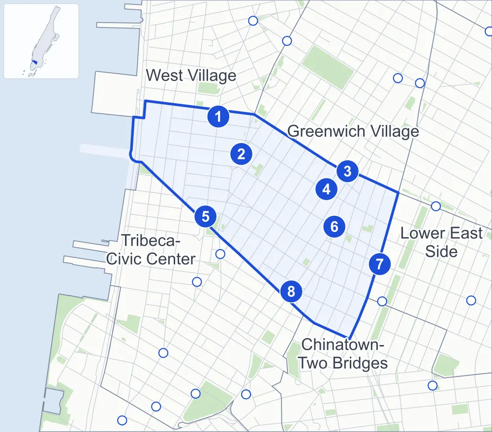
Between Houston and Canal Streets, SoHo-Little Italy-Hudson Square runs from the Hudson River east to the Bowery.
- 0.46 square miles
- 23,287 residents, 2020 Census
- 126 street corners
- 8 subway stations
- 17 bus routes
SoHo, named in 1962 for lying south of Houston Street, filled with cast-iron lofts for dry goods merchants in the mid-to-late 1800s; artists moved in during the 1960s, and its historic district dates from 1973. Little Italy grew with Italian immigration in the 1880s, and the Feast of San Gennaro, begun in 1926, is now an 11-day street fair on Mulberry Street. Hudson Square, once the Printing District, holds the Holland Tunnel entrance, opened in 1927, and row houses from the first half of the 1800s on Charlton, King and Vandam Streets.
Sources: SoHo, Manhattan (Wikipedia); SoHo-Cast Iron Historic District Extension Designation Report (LP-2362) (NYC Landmarks Preservation Commission); Little Italy, Manhattan (Wikipedia); Hudson Square (Wikipedia).
SoHo-Little Italy-Hudson Square borders five areas, and Broome Street and Spring Street hold more of its corners than any other street, 18 each of 126.
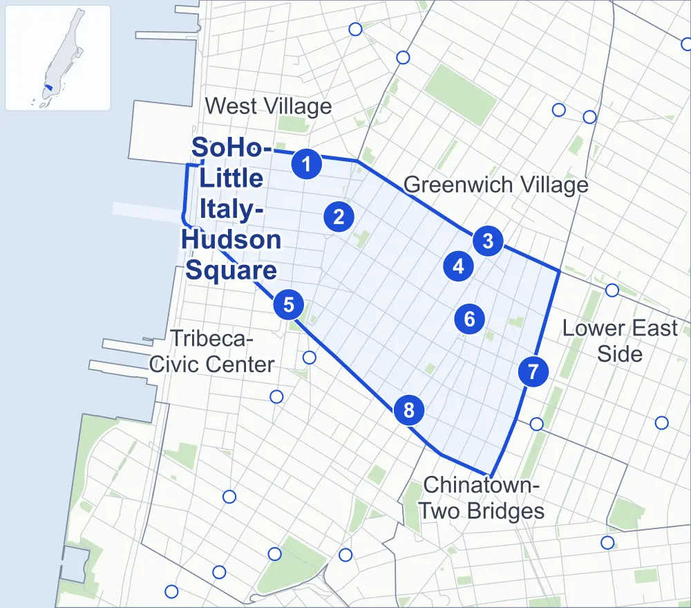
- SoHo-Little Italy-Hudson Square
- A neighboring area
- Park
- A station in the list
- Another station
Neighborhood areas and streets: NYC Department of City Planning. Parks: NYC Parks. Stations: MTA.
Neighboring areas
- Greenwich Village northeast
- Lower East Side east
- Chinatown-Two Bridges southeast
- Tribeca-Civic Center southwest
- West Village northwest
Subway stations
- Houston St lines 1
- Spring St lines C E
- Broadway-Lafayette St lines B D F M accessible
- Prince St lines R W
- Canal St lines 1
- Spring St lines 6
- Bowery lines J Z
- Canal St lines 6 J N Q R W Z
Getting around
Eight subway stations and buses on 17 routes stop in or at the edge of SoHo-Little Italy-Hudson Square.
- 8 subway stations
- 1 of them listed by the MTA as fully accessible
- 6 local bus routes
- 11 express bus routes
Local bus routes
- M1
- M20
- M21
- M55
- M103
- T232
Express bus routes
- SIM1
- SIM1C
- SIM3C
- SIM4C
- SIM7
- SIM9
- SIM33
- SIM33C
- SIM34
- X27
- X28
Safety record
Between 2021 and 2025, its corners averaged fewer police-reported crashes than the average Manhattan corner.
- 1,647 police-reported crashes at its corners
- 13.1 a corner, on average
- 13.4 the average Manhattan corner
- 6 corners with a clean record
Signal or safety changes on City record, at 29 of its corners
- Leading pedestrian intervals
- 20
- Accessible pedestrian signals
- 14
- Turn calming
- 7
- Barnes Dance all-way crossings
- 5
- Enhanced crossings
- 1
- Safety Improvement Projects
- 1
Camera tickets
In 2025 its corners had more school-zone speed camera tickets than bus-lane or red-light tickets.
- 0 red-light camera tickets
- 12,040 school-zone speed camera tickets at five corners
- 5,021 bus-lane camera tickets at one corner
- Most speed tickets
- Avenue of the Americas & Canal Street, 3,373
- Most bus-lane tickets
- Broadway & Howard Street, 5,021
People and homes
The 2020 Census counted 23,287 residents in SoHo-Little Italy-Hudson Square, about 50,600 per square mile.
- 14,571 homes, 2020 Census
- 1,776 homes added since April 2010, net, by City Planning's count
Half of its 1,133 residential lots hold buildings from 1900 or earlier, and 91% of them date from before 1940, by the City's tax lot records.
Parks and landmarks
- Parkland
- 2.6 acres of NYC Parks property
- The largest pieces
- Vesuvio Playground (0.6 acre), Park (0.5 acre) and Duarte Square (0.4 acre)
- Designated landmarks
- The New York City Police Headquarters, the Odd Fellows Hall, the Fire Engine Company 55 and the Holland Plaza Building, among others
- Historic districts
- Charlton-King-Vandam, SoHo-Cast Iron and Sullivan-Thompson, wholly or partly within SoHo-Little Italy-Hudson Square
Streets and trees
- Trees
- 1,530 in NYC Parks' records, most often thornless honeylocust, Japanese zelkova and maidenhair tree
- Street with the most corners
- Broome Street, with 18 of the area's 126
- Height above sea level
- From 3 feet at Grand Street & West Broadway to 46 feet at East Houston Street & Elizabeth Street
- Honorary street names
- 7 at its corners, enacted by local law
Schools and libraries
The City lists five schools and one library in SoHo-Little Italy-Hudson Square.
- Public schools
- 3
- Charter and private schools
- 2
- Library
- Mulberry Street Library
Bike share and public art
By the station list of October 3, 2026, 21 bike-share stations stand in SoHo-Little Italy-Hudson Square. The City's public art inventory lists three works in the area: Juan Pablo Duarte (1978), Subway Map Floating on a New York Sidewalk (1985) and General José Artigas (1987).
- 21 bike-share stations
- 3 works of public art
Places the City draws by name in this area: SoHo, Little Italy and Hudson Square.
Public safety
How complaints are countedIn 2025 the NYPD recorded 971 major felonies at places in SoHo-Little Italy-Hudson Square.
Recorded by the NYPD at places in SoHo-Little Italy-Hudson Square
- 1,041 major felonies in 2024
- 2,866 other felonies, misdemeanors and violations in 2025
In 2025, on the streets along the edge of SoHo-Little Italy-Hudson Square, the NYPD recorded another 186 major felonies.
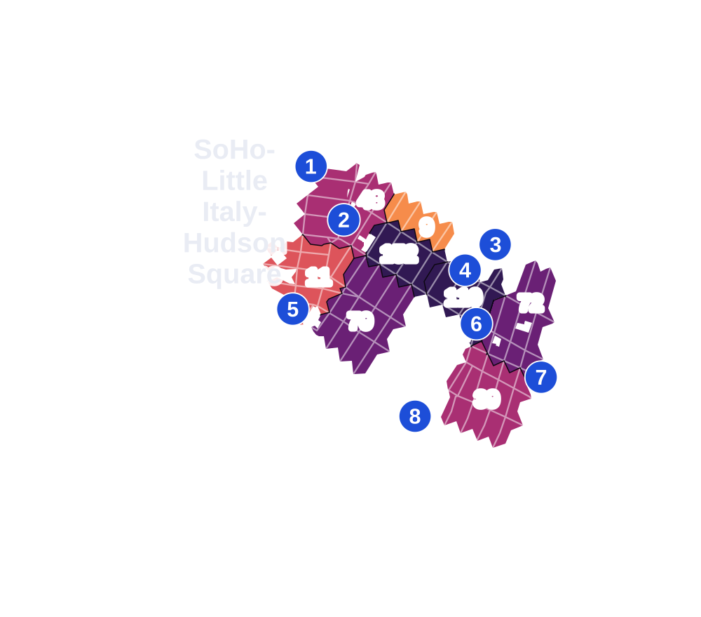
- 5 to 9
- 10 to 19
- 20 to 49
- 50 to 99
- 100 or more
- Not shaded: fewer than 5, held back under the rules in How complaints are counted, parks and public-housing grounds, and land in no patch
- Police precincts
- 1st (most of the area), 5th
From January to June 2026 the NYPD recorded 464 major felonies at places in SoHo-Little Italy-Hudson Square, against 455 in the same months of 2025.
Sources: the NYPD's Complaint Data Historic, updated April 28, 2026, and Complaint Data Current (Year To Date), updated July 27, 2026, on NYC Open Data. Figures to June 30, 2026.
Street corners
- Avenue of the Americas & Broome Street
- Avenue of the Americas & Canal Street
- Avenue of the Americas & Dominick Street
- Avenue of the Americas & Grand Street
- Avenue of the Americas & King Street
- Avenue of the Americas & Prince Street
- Avenue of the Americas & Spring Street
- Avenue of the Americas & Sullivan Street
- Avenue of the Americas & Thompson Street
- Avenue of the Americas & Vandam Street
- Avenue of the Americas & West Houston Street
- Bowery & Hester Street
- Bowery & Prince Street
- Bowery & Rivington Street
- Broadway & Broome Street
- Broadway & Grand Street
- Broadway & Howard Street
- Broadway & Prince Street
- Broadway & Spring Street
- Broome Street & Centre Market Place
- Broome Street & Centre Street
- Broome Street & Crosby Street
- Broome Street & Elizabeth Street
- Broome Street & Greene Street
- Broome Street & Holland Tunnel
- Broome Street & Lafayette Street
- Broome Street & Mercer Street
- Broome Street & Mott Street
- Broome Street & Mulberry Street
- Broome Street & Sullivan Street
- Broome Street & Thompson Street
- Broome Street & Varick Street
- Broome Street & West Broadway
- Broome Street & Wooster Street
- Canal Street & Centre Street
- Canal Street & Church Street
- Canal Street & Cortlandt Alley
- Canal Street & Elizabeth Street
- Canal Street & Lafayette Street
- Canal Street & Varick Street
- Centre Street & Hester Street
- Centre Street & Howard Street
- Cleveland Place & Kenmare Street
- Crosby Street & Howard Street
- Crosby Street & Jersey Street
- Crosby Street & Prince Street
- East Houston Street & Bowery
- East Houston Street & Elizabeth Street
- Elizabeth Street & Hester Street
- Elizabeth Street & Kenmare Street
- Elizabeth Street & Prince Street
- Grand Street & Baxter Street
- Grand Street & Bowery
- Grand Street & Centre Street
- Grand Street & Crosby Street
- Grand Street & Elizabeth Street
- Grand Street & Greene Street
- Grand Street & Lafayette Street
- Grand Street & Mercer Street
- Grand Street & Mott Street
- Grand Street & Mulberry Street
- Grand Street & Thompson Street
- Grand Street & Varick Street
- Grand Street & West Broadway
- Grand Street & Wooster Street
- Greene Street & Prince Street
- Greenwich Street & Charlton Street
- Greenwich Street & King Street
- Greenwich Street & Spring Street
- Greenwich Street & Vandam Street
- Greenwich Street & West Houston Street
- Hester Street & Baxter Street
- Hudson Street & Broome Street
- Hudson Street & Canal Street at Holland Tunnel
- Hudson Street & Charlton Street
- Hudson Street & Dominick Street
- Hudson Street & King Street
- Hudson Street & Spring Street
- Hudson Street & Vandam Street
- Hudson Street & West Houston Street
- Lafayette Street & East Houston Street
- Lafayette Street & Howard Street
- Lafayette Street & Jersey Street
- Lafayette Street & Kenmare Street
- Lafayette Street & Prince Street
- Lafayette Street & Spring Street
- MacDougal Street & King Street
- Mercer Street & Howard Street
- Mercer Street & Prince Street
- Mercer Street & West Houston Street
- Mott Street & Hester Street
- Mott Street & Kenmare Street
- Mott Street & Prince Street
- Mott Street & Spring Street
- Mulberry Street & Hester Street
- Mulberry Street & Jersey Street
- Mulberry Street & Kenmare Street
- Mulberry Street & Prince Street
- Mulberry Street & Spring Street
- Prince Street & MacDougal Street
- Prince Street & Wooster Street
- Spring Street & Crosby Street
- Spring Street & Elizabeth Street
- Spring Street & Greene Street
- Spring Street & Mercer Street
- Spring Street & Renwick Street
- Spring Street & Sullivan Street
- Spring Street & Thompson Street
- Spring Street & Varick Street
- Spring Street & Wooster Street
- Sullivan Street & Prince Street
- Thompson Street & Prince Street
- Thompson Street & Watts Street
- Varick Street & Charlton Street
- Varick Street & Dominick Street
- Varick Street & King Street
- Varick Street & Vandam Street
- Varick Street & Watts Street
- Washington Street & Spring Street
- Watts Street & Holland Tunnel
- West Broadway & Prince Street
- West Broadway & Spring Street
- West Broadway & West Houston Street
- West Houston Street & MacDougal Street
- West Street & Canal Street
- West Street & Holland Tunnel
How the figures above are measured: Methodology.