Tribeca-Civic Center
Neighborhood · Manhattan
Tribeca-Civic Center runs from Canal Street south to City Hall Park, joining Tribeca's former warehouse blocks west of Broadway with the government buildings and courthouses around Foley Square.
- 0.49 square miles
- 25,390 residents, 2020 Census
- 165 street corners
- 8 subway stations
- 31 bus routes
Tribeca, short for Triangle Below Canal, got its name in the early 1970s, as artists were settling into lofts in its old warehouses, and four historic districts now protect its streets. City Hall, designed by Joseph Mangin and John McComb, opened in 1812 on the old Commons, a shared pasture in the late 1600s. Nearby, the African Burial Ground National Monument honors the free and enslaved Africans buried there from the mid-1630s to 1795.
Sources: Tribeca (Wikipedia); Civic Center, Manhattan (Wikipedia); City Hall Park (NYC Parks); History & Culture - African Burial Ground National Monument (National Park Service).
Tribeca-Civic Center borders three areas, and Greenwich Street and West Broadway hold more of its corners than any other street, 19 each of 165.
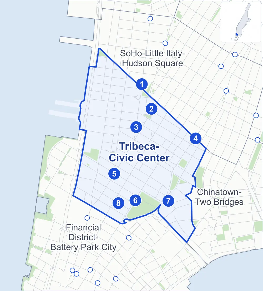
- Tribeca-Civic Center
- A neighboring area
- Park
- A station in the list
- Another station
Neighborhood areas and streets: NYC Department of City Planning. Parks: NYC Parks. Stations: MTA.
Neighboring areas
- SoHo-Little Italy-Hudson Square north
- Chinatown-Two Bridges southeast
- Financial District-Battery Park City south
Subway stations
- Canal St lines 1
- Canal St lines A C E
- Franklin St lines 1
- Canal St lines J N Q R W Z
- Chambers St lines 1 2 3 accessible
- City Hall lines R W
- Brooklyn Bridge-City Hall / Chambers St lines 4 5 6 J Z accessible
- Chambers St / Park Place / World Trade Center lines 2 3 A C E
Getting around
Eight subway stations and buses on 31 routes stop in or at the edge of Tribeca-Civic Center.
- 8 subway stations
- 2 of them listed by the MTA as fully accessible
- 6 local bus routes
- 25 express bus routes
Local bus routes
- M9
- M15
- M20
- M22
- M55
- M103
Express bus routes
- BM1
- BM2
- BM3
- BM4
- BxM18
- QM7
- QM8
- QM11
- QM25
- QM65
- SIM1
- SIM1C
- SIM2
- SIM3C
- SIM4
- SIM4C
- SIM7
- SIM9
- SIM15
- SIM32
- SIM33
- SIM33C
- SIM34
- X27
- X28
Safety record
Between 2021 and 2025, its corners averaged fewer police-reported crashes than the average Manhattan corner.
- 1,379 police-reported crashes at its corners
- 8.4 a corner, on average
- 13.4 the average Manhattan corner
- 23 corners with a clean record
Signal or safety changes on City record, at 36 of its corners
- Leading pedestrian intervals
- 15
- Accessible pedestrian signals
- 13
- Barnes Dance all-way crossings
- 13
- Turn calming
- 7
- Safety Improvement Projects
- 1
Camera tickets
In 2025 its corners had more bus-lane camera tickets than school-zone speed or red-light tickets.
- 0 red-light camera tickets
- 808 school-zone speed camera tickets at one corner
- 20,864 bus-lane camera tickets at two corners
- Most speed tickets
- Canal Street & Laight Street, 808
- Most bus-lane tickets
- Broadway & Park Row at Barclay Street, 16,416
People and homes
The 2020 Census counted 25,390 residents in Tribeca-Civic Center, about 51,800 per square mile.
- 11,994 homes, 2020 Census
- 2,371 homes added since April 2010, net, by City Planning's count
Half of its 622 residential lots hold buildings from 1895 or earlier, and 88% of them date from before 1940, by the City's tax lot records.
Parks and landmarks
- Parkland
- 16 acres of NYC Parks property
- The largest pieces
- City Hall Park (9.4 acres), Washington Market Park (2.2 acres) and Thomas Paine Park (1.9 acres)
- Designated landmarks
- The Fleming Smith Warehouse, the Long Distance Building, the Ahrens Building and the New York Life Insurance Building, among others
- Historic districts
- African Burial Ground & The Commons, Tribeca East, Tribeca North, Tribeca South, Tribeca South Extension and Tribeca West, wholly or partly within Tribeca-Civic Center
Streets and trees
- Trees
- 1,654 in NYC Parks' records, most often thornless honeylocust, London planetree and Japanese zelkova
- Street with the most corners
- Greenwich Street, with 19 of the area's 165
- Height above sea level
- From 5 feet at Washington Street & Barclay Street to 40 feet at Park Row & Centre Street
- Honorary street names
- 12 at its corners, enacted by local law
Schools and libraries
The City lists ten schools and one library in Tribeca-Civic Center.
- Public schools
- 5
- Charter and private schools
- 5
- Library
- New Amsterdam Library
Bike share and public art
By the station list of October 3, 2026, 23 bike-share stations stand in Tribeca-Civic Center. The City's public art inventory lists eight works in the area, among them City Hall Park Fountain (1871), Nathan Hale (1893) and Abraham De Peyster (1896).
- 23 bike-share stations
- 8 works of public art
Places the City draws by name in this area: Tribeca.
Public safety
How complaints are countedIn 2025 the NYPD recorded 467 major felonies at places in Tribeca-Civic Center.
Recorded by the NYPD at places in Tribeca-Civic Center
- 442 major felonies in 2024
- 2,187 other felonies, misdemeanors and violations in 2025
In 2025, on the streets along the edge of Tribeca-Civic Center, the NYPD recorded another 102 major felonies.
- Police precincts
- 1st (most of the area), 5th
From January to June 2026 the NYPD recorded 266 major felonies at places in Tribeca-Civic Center, against 215 in the same months of 2025.
Sources: the NYPD's Complaint Data Historic, updated April 28, 2026, and Complaint Data Current (Year To Date), updated July 27, 2026, on NYC Open Data. Figures to June 30, 2026.
Street corners
- Avenue of the Americas & Church Street
- Avenue of the Americas & Laight Street
- Avenue of the Americas & Walker Street
- Avenue of the Americas & West Broadway
- Avenue of the Americas & White Street
- Avenue of the Americas & York Street
- Baxter Street & Hogan Place
- Beach Street & Collister Street
- Beach Street & St Johns Lane
- Broadway & Canal Street
- Broadway & Catherine Lane
- Broadway & Chambers Street
- Broadway & Duane Street
- Broadway & Franklin Street
- Broadway & Leonard Street
- Broadway & Lispenard Street
- Broadway & Murray Street
- Broadway & Park Place
- Broadway & Park Row at Barclay Street
- Broadway & Park Row at Vesey Street
- Broadway & Reade Street
- Broadway & Thomas Street
- Broadway & Walker Street
- Broadway & Warren Street
- Broadway & White Street
- Broadway & Worth Street
- Brooklyn Bridge & Centre Street
- Brooklyn Bridge & FDR Drive at Rose Street
- Canal Street & Greene Street
- Canal Street & Laight Street
- Canal Street & Mercer Street
- Canal Street & Renwick Street
- Canal Street & West Broadway
- Canal Street & Wooster Street
- Cardinal Hayes Place & St Andrews Plaza
- Centre Street & Brooklyn Bridge Pedestrian Path
- Centre Street & Duane Street
- Centre Street & Hamill Place
- Centre Street & Leonard Street
- Centre Street & Walker Street
- Centre Street & White Street
- Chambers Street & Centre Street
- Chambers Street & Elk Street
- Church Street & Barclay Street
- Church Street & Chambers Street
- Church Street & Duane Street
- Church Street & Leonard Street
- Church Street & Lispenard Street
- Church Street & Murray Street
- Church Street & Park Place
- Church Street & Reade Street
- Church Street & Thomas Street
- Church Street & Walker Street
- Church Street & Warren Street
- Church Street & White Street
- Church Street & Worth Street
- Duane Street & Elk Street
- Duane Street & Staple Street
- Duane Street & Trimble Place
- Ericsson Place & Holland Tunnel
- Franklin Street & Benson Place
- Franklin Street & Cortlandt Alley
- Franklin Street & Franklin Place
- Greenwich Street & Barclay Street
- Greenwich Street & Beach Street
- Greenwich Street & Canal Street
- Greenwich Street & Chambers Street
- Greenwich Street & Desbrosses Street
- Greenwich Street & Duane Street
- Greenwich Street & Franklin Street
- Greenwich Street & Harrison Street
- Greenwich Street & Hubert Street
- Greenwich Street & Jay Street
- Greenwich Street & Laight Street
- Greenwich Street & Murray Street
- Greenwich Street & North Moore Street
- Greenwich Street & Park Place
- Greenwich Street & Reade Street
- Greenwich Street & Vestry Street
- Greenwich Street & Warren Street
- Greenwich Street & Watts Street
- Greenwich Street & West Broadway
- Harrison Street & Staple Street
- Holland Tunnel & Holland Tunnel Exit Pedestrian Overpass
- Hubert Street & Collister Street
- Hudson Street & Beach Street
- Hudson Street & Canal Street at Holland Tunnel
- Hudson Street & Desbrosses Street
- Hudson Street & Duane Street
- Hudson Street & Franklin Street
- Hudson Street & Harrison Street
- Hudson Street & Holland Tunnel
- Hudson Street & Hubert Street
- Hudson Street & Jay Street
- Hudson Street & Laight Street
- Hudson Street & Leonard Street
- Hudson Street & North Moore Street
- Hudson Street & Reade Street
- Hudson Street & Thomas Street
- Hudson Street & Vestry Street
- Hudson Street & West Broadway
- Hudson Street & Worth Street
- Lafayette Street & Catherine Lane
- Lafayette Street & Centre Street
- Lafayette Street & Duane Street
- Lafayette Street & Franklin Street
- Lafayette Street & Leonard Street
- Lafayette Street & Walker Street
- Lafayette Street & White Street
- Lafayette Street & Worth Street
- Laight Street & Collister Street
- Laight Street & Holland Tunnel Exit Pedestrian Overpass
- Laight Street & St Johns Lane
- Leonard Street & Benson Place
- Madison Street & Avenue of the Finest
- Park Row & Brooklyn Bridge
- Park Row & Centre Street
- Park Row & St Andrews Plaza
- Pearl Street & Centre Street
- Pearl Street & Madison Street
- Pearl Street & Park Row
- Pearl Street & R F Wagner Sr Place
- Reade Street & Elk Street
- St Johns Lane & York Street
- Staple Street & Jay Street
- Thomas Street & Trimble Place
- Varick Street & Beach Street
- Varick Street & Holland Tunnel
- Varick Street & Laight Street
- Varick Street & North Moore Street
- Walker Street & Cortlandt Alley
- Washington Street & Barclay Street
- Washington Street & Canal Street
- Washington Street & Canal Street at Holland Tunnel
- Washington Street & Desbrosses Street
- Washington Street & Hubert Street
- Washington Street & Laight Street
- Washington Street & Vesey Street
- Washington Street & Vestry Street
- Washington Street & Watts Street
- West Broadway & Barclay Street
- West Broadway & Beach Street
- West Broadway & Duane Street
- West Broadway & Franklin Street
- West Broadway & Leonard Street
- West Broadway & Murray Street
- West Broadway & North Moore Street
- West Broadway & Park Place
- West Broadway & Reade Street
- West Broadway & Thomas Street
- West Broadway & Varick Street
- West Broadway & Walker Street
- West Broadway & Warren Street
- West Broadway & White Street
- West Broadway & Worth Street
- West Street & Laight Street
- West Street & North Moore Street
- West Street & Vestry Street
- West Street & Watts Street
- White Street & Baxter Street
- White Street & Cortlandt Alley
- White Street & Franklin Place
- Worth Street & Cardinal Hayes Place
- Worth Street & Centre Street
- Worth Street & Hamill Place
How the figures above are measured: Methodology.