Lower East Side
Neighborhood · Manhattan
The Lower East Side lies between the Bowery and the East River, running from Houston Street south to Canal Street.
- 0.59 square miles
- 49,149 residents, 2020 Census
- 127 street corners
- 4 subway stations
- 13 bus routes
In the 1760s the Delancey family began laying out streets on part of its farm here, and Delancey Street still carries the name. Large numbers of German immigrants settled here by the 1840s, followed by Italians and Eastern European Jews, along with Greeks, Hungarians, Poles, Romanians and others. Seward Park's playground, opened in 1903, was the first permanent playground built by a city in the United States, and the Tenement Museum on Orchard Street has told the stories of tenement residents since 1988.
Sources: Lower East Side (Wikipedia); Seward Park (NYC Parks); About Us (Tenement Museum).
Lower East Side borders three areas, and Delancey Street holds more of its corners than any other street, 23 of 127.
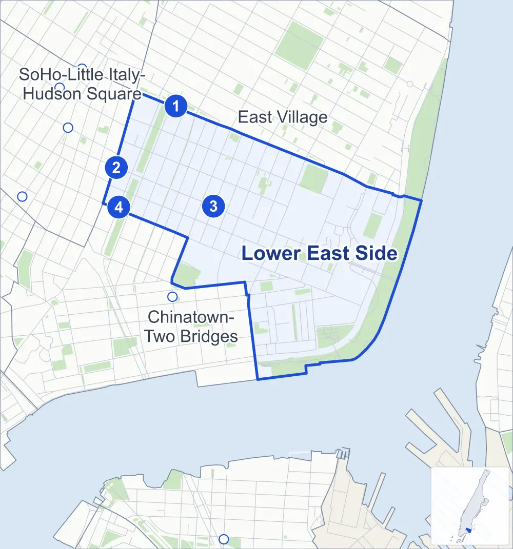
- Lower East Side
- A neighboring area
- Park
- A station in the list
- Another station
Neighborhood areas and streets: NYC Department of City Planning. Parks: NYC Parks. Stations: MTA.
Neighboring areas
- East Village north
- Chinatown-Two Bridges southwest
- SoHo-Little Italy-Hudson Square northwest
Subway stations
- 2 Av lines F
- Bowery lines J Z
- Delancey St-Essex St lines F J M Z
- Grand St lines B D
Getting around
Four subway stations and buses on 13 routes stop in or at the edge of Lower East Side.
- 4 subway stations
- 13 local bus routes
Local bus routes
- B39
- B106
- L92
- M9
- M14A-SBS
- M14D-SBS
- M15
- M15-SBS
- M21
- M22
- M103
- T232
- T432
Safety record
Between 2021 and 2025, its corners averaged more police-reported crashes than the average Manhattan corner.
- 1,924 police-reported crashes at its corners
- 15.1 a corner, on average
- 13.4 the average Manhattan corner
- 17 corners with a clean record
Signal or safety changes on City record, at 35 of its corners
- Accessible pedestrian signals
- 16
- Leading pedestrian intervals
- 13
- Barnes Dance all-way crossings
- 11
- Turn calming
- 6
- Enhanced crossings
- 4
- Safety Improvement Projects
- 1
Camera tickets
In 2025 its corners had more bus-lane camera tickets than red-light or school-zone speed tickets.
- 0 red-light camera tickets
- 0 school-zone speed camera tickets
- 2,516 bus-lane camera tickets at two corners
- Most bus-lane tickets
- Delancey Street & Allen Street, 2,214
People and homes
The 2020 Census counted 49,149 residents in Lower East Side, about 83,300 per square mile.
- 24,328 homes, 2020 Census
- 3,088 homes added since April 2010, net, by City Planning's count
Half of its 669 residential lots hold buildings from 1910 or earlier, and 82% of them date from before 1940, by the City's tax lot records.
NYCHA developments
NYCHA's Baruch, Baruch Houses Addition, Gompers, Hernandez, Lower East Side I Infill, Seward Park Extension, Vladeck and Vladeck II developments lie wholly or partly within Lower East Side, as does one more that NYCHA names by a building's address.
Parks and landmarks
- Parkland
- 56 acres of NYC Parks property
- The largest pieces
- John V. Lindsay East River Park (24.4 acres), Sara D. Roosevelt Park (5.5 acres) and Pier 42 (5.4 acres)
- Designated landmarks
- The Kehila Kadosha Janina Synagogue, the Neighborhood Playhouse, the Willett Street Methodist Episcopal Church and the (former) All Saints' Free Church, among others
Streets and trees
- Trees
- 2,852 in NYC Parks' records, most often London planetree, thornless honeylocust and pin oak
- Street with the most corners
- Delancey Street, with 23 of the area's 127
- Height above sea level
- From 7 feet at FDR Drive & Grand Street to 43 feet at Bowery & Stanton Street
- Honorary street names
- 11 at its corners, enacted by local law
Schools and libraries
The City lists 24 schools and two libraries in Lower East Side.
- Public schools
- 20
- Charter and private schools
- 4
- Libraries
- Hamilton Fish Park Library and Seward Park Library
Bike share and public art
By the station list of October 3, 2026, 22 bike-share stations stand in Lower East Side. The City's public art inventory lists two works in the area: Jacob H. Schiff Fountain (1895) and Large Coqui (2007).
- 22 bike-share stations
- 2 works of public art
Public safety
How complaints are countedIn 2025 the NYPD recorded 805 major felonies at places in the Lower East Side.
Recorded by the NYPD at places in the Lower East Side
- 824 major felonies in 2024
- 3,130 other felonies, misdemeanors and violations in 2025
In 2025, on the streets along the edge of the Lower East Side, the NYPD recorded another 204 major felonies. Counting the streets along its edge, in 2025 the NYPD recorded 20.5 major felonies for every thousand residents the 2020 Census counted in the Lower East Side.
- Police precincts
- 7th (most of the area), 5th
From January to June 2026 the NYPD recorded 420 major felonies at places in the Lower East Side, against 366 in the same months of 2025.
Sources: the NYPD's Complaint Data Historic, updated April 28, 2026, and Complaint Data Current (Year To Date), updated July 27, 2026, on NYC Open Data. Figures to June 30, 2026.
Street corners
- Baruch Drive & Pedestrian Path (north)
- Baruch Drive & Pedestrian Path (south)
- Bowery & Stanton Street
- Broome Street & Allen Street
- Broome Street & Attorney Street
- Broome Street & Bialystoker Place
- Broome Street & Bowery
- Broome Street & Cannon Street
- Broome Street & Chrystie Street
- Broome Street & Clinton Street
- Broome Street & Columbia Street
- Broome Street & Eldridge Street
- Broome Street & Essex Street
- Broome Street & Forsyth Street
- Broome Street & Lewis Street
- Broome Street & Ludlow Street
- Broome Street & Norfolk Street
- Broome Street & Orchard Street
- Broome Street & Pitt Street
- Broome Street & Ridge Street
- Broome Street & Suffolk Street
- Canal Street & East Broadway
- Cherry Street & Corlears Hook Park Path
- Cherry Street & Jackson Street
- Clinton Street & Rivington Street
- Corlears Hook Park Path & Corlears Hook Park Overpass
- Delancey Street & Allen Street
- Delancey Street & Bowery
- Delancey Street & Chrystie Street
- Delancey Street & Eldridge Street
- Delancey Street & Essex Street
- Delancey Street & Forsyth Street
- Delancey Street & Ludlow Street
- Delancey Street & Norfolk Street
- Delancey Street & Orchard Street
- Delancey Street & Suffolk Street
- Delancey Street & Williamsburg Bridge Bike and Pedestrian Path
- East Broadway & Jefferson Street
- East Broadway & Samuel Dickstein Plaza
- East Houston Street & Attorney Street
- East Houston Street & Avenue A
- East Houston Street & Baruch Place
- East Houston Street & Ridge Street
- East River Esplanade & Corlears Hook Park Overpass
- East River Esplanade & E Houston Street Pedestrian Overpass
- East River Esplanade & East River Park Path at Delancey Street Pedestrian Overpass
- Eldridge Street & Rivington Street
- Essex Street & Rivington Street
- FDR Drive & Cherry Street
- FDR Drive & Corlears Hook Park Overpass
- FDR Drive & Delancey Street Pedestrian Overpass
- FDR Drive & Gouverneur Slip East
- FDR Drive & Gouverneur Slip West
- FDR Drive & Grand Street
- FDR Drive & Montgomery Street
- FDR Drive & Williamsburg Bridge
- FDR Drive & Williamsburg Bridge Bike Path
- FDR Drive & Williamsburg Bridge Pedestrian Path
- Forsyth Street & East Houston Street
- Forsyth Street & Rivington Street
- Forsyth Street & Stanton Street
- Grand Street & Abraham Kazan Street
- Grand Street & Attorney Street
- Grand Street & Bialystoker Place
- Grand Street & Chrystie Street
- Grand Street & Clinton Street
- Grand Street & East Broadway
- Grand Street & Eldridge Street
- Grand Street & Henry Street
- Grand Street & Jackson Street
- Grand Street & Lewis Street
- Grand Street & Ludlow Street
- Grand Street & Madison Street
- Grand Street & Norfolk Street
- Grand Street & Pitt Street
- Grand Street & Suffolk Street
- Henry Street & Gouverneur Street
- Henry Street & Montgomery Street at Samuel Dickstein Plaza
- Jackson Street & Corlears Hook Park Path
- Ludlow Street & Rivington Street
- Madison Street & Gouverneur Street
- Madison Street & Jackson Street
- Monroe Street & Gouverneur Street
- Orchard Street & Rivington Street
- Rivington Street & Allen Street
- Rivington Street & Attorney Street
- Rivington Street & Chrystie Street
- Rivington Street & Columbia Street
- Rivington Street & Freeman Alley
- Rivington Street & Norfolk Street
- Rivington Street & Pitt Street
- Rivington Street & Ridge Street
- Rivington Street & Suffolk Street
- Spring Street & Bowery
- Stanton Street & Allen Street
- Stanton Street & Attorney Street
- Stanton Street & Baruch Place
- Stanton Street & Chrystie Street
- Stanton Street & Clinton Street
- Stanton Street & Columbia Street
- Stanton Street & Eldridge Street
- Stanton Street & Essex Street
- Stanton Street & Ludlow Street
- Stanton Street & Mangin Street
- Stanton Street & Norfolk Street
- Stanton Street & Orchard Street
- Stanton Street & Pitt Street
- Stanton Street & Ridge Street
- Stanton Street & Sheriff Street
- Stanton Street & Suffolk Street
- Water Street & Gouverneur Slip East
- Water Street & Gouverneur Slip West
- Water Street & Gouverneur Street
- Water Street & Jackson Street
- Williamsburg Bridge & Delancey Street
- Williamsburg Bridge & Delancey Street at Baruch Place
- Williamsburg Bridge & Delancey Street at Bialystoker Place
- Williamsburg Bridge & Delancey Street at Clinton Street
- Williamsburg Bridge & Delancey Street at Columbia Street
- Williamsburg Bridge & Delancey Street at Lewis Street
- Williamsburg Bridge & Delancey Street at Mangin Street
- Williamsburg Bridge & Delancey Street at Pitt Street
- Williamsburg Bridge & Delancey Street at Ridge Street
- Williamsburg Bridge & Delancey Street at Sheriff Street
- Williamsburg Bridge & Delancey Street at Williamsburg Bridge Pedestrian Path
- Williamsburg Bridge & East River Esplanade
- Williamsburg Bridge & FDR Drive
How the figures above are measured: Methodology.