Brooklyn Navy Yard
Brooklyn
The Brooklyn Navy Yard occupies the East River shore, bounded inland by Navy Street, Flushing Avenue and Kent Avenue.
- 0.36 square miles
- 67 street corners
- 4 bus routes
Established in 1801, it built and repaired Navy ships for 165 years, among them the battleships Arizona and Missouri, and at its World War II peak employed tens of thousands of workers. After the Navy decommissioned it in 1966, the yard was sold to the City of New York; today it is managed by the nonprofit Brooklyn Navy Yard Development Corporation, with Building 92 serving as its exhibition, visitor and employment center.
Sources: History (Brooklyn Navy Yard); Brooklyn Navy Yard (Wikipedia).
Brooklyn Navy Yard borders four areas, and Flushing Avenue holds more of its corners than any other street, ten of 67.
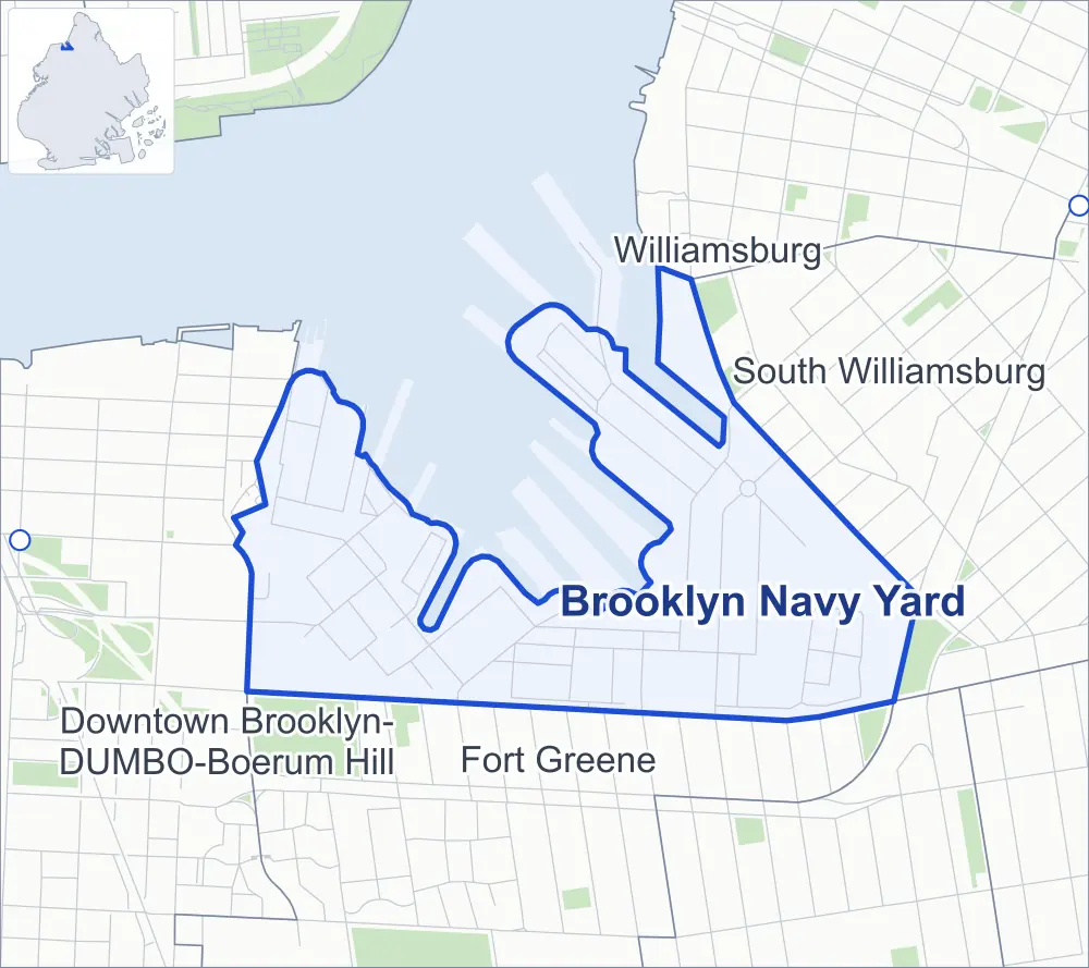
- Brooklyn Navy Yard
- A neighboring area
- Park
- Another station
Neighborhood areas and streets: NYC Department of City Planning. Parks: NYC Parks. Stations: MTA.
Neighboring areas
- Williamsburg north
- South Williamsburg east
- Fort Greene south
- Downtown Brooklyn-DUMBO-Boerum Hill west
Getting around
Buses on four routes stop in or at the edge of Brooklyn Navy Yard.
- 4 local bus routes
Local bus routes
- B57
- B62
- B67
- B69
Safety record
Between 2021 and 2025, its corners averaged fewer police-reported crashes than the average Brooklyn corner.
- 173 police-reported crashes at its corners
- 2.6 a corner, on average
- 10.5 the average Brooklyn corner
- 52 corners with a clean record
Signal or safety changes on City record, at five of its corners
- Turn calming
- 3
- Leading pedestrian intervals
- 2
Camera tickets
In 2025 its corners had more red-light camera tickets than school-zone speed or bus-lane tickets.
- 5,613 red-light camera tickets at one corner
- 764 school-zone speed camera tickets at one corner
- 0 bus-lane camera tickets
- Most red-light tickets
- Flushing Avenue & Williamsburg Street West, 5,613
- Most speed tickets
- Flushing Avenue & Waverly Avenue, 764
Landmarks
- Designated landmarks
- The Dry Dock Number 1, the United States Naval Hospital and the Surgeon's House
Streets and trees
- Trees
- 118 in NYC Parks' records, most often common hackberry, thornless honeylocust and hackberry
- Street with the most corners
- Flushing Avenue, with ten of the area's 67
- Height above sea level
- From 5 feet at Gee Avenue & Kay Avenue to 40 feet at Steiner Street & Neilson Street
Bike share
By the station list of October 3, 2026, seven bike-share stations stand in Brooklyn Navy Yard.
- 7 bike-share stations
Street corners
- 2nd Street & Chauncey Avenue
- 2nd Street & Dock Avenue
- 2nd Street & Eastway
- 2nd Street & Front Avenue
- 2nd Street & Morris Avenue
- 3rd Street & Chauncey Avenue
- 3rd Street & Dock Avenue
- 3rd Street & Morris Avenue
- 3rd Street & Perry Avenue
- 3rd Street & Sands Street
- 3rd Street & Warrington Avenue
- 4th Street & Chauncey Avenue
- 4th Street & Morris Avenue
- 4th Street & Perry Avenue
- 4th Street & Warrington Avenue
- 5th Street & Chauncey Avenue
- 5th Street & Market Street
- 5th Street & Morris Avenue
- 5th Street & Ordnance Avenue
- 6th Street & Farragut Street
- 6th Street & Market Street
- 6th Street & Morris Avenue
- 7th Avenue & 6th Street at Paulding Street
- 7th Avenue & Farragut Street
- 7th Avenue & South Street
- 8th Avenue & Farragut Street
- 8th Avenue & Market Street
- 8th Avenue & Paulding Street
- 8th Avenue & South Street
- 9th Avenue & Paulding Street
- 9th Avenue & South Street
- 10th Avenue & Clinton Avenue
- 10th Avenue & Market Street
- 14th Avenue & Paulding Street
- 14th Avenue & South Street
- Eastway & Front Avenue
- Flushing Avenue & Adelphi Street
- Flushing Avenue & Clinton Avenue
- Flushing Avenue & Grand Avenue
- Flushing Avenue & North Elliott Place
- Flushing Avenue & North Oxford Street
- Flushing Avenue & Ryerson Street
- Flushing Avenue & Steuben Street
- Flushing Avenue & Vanderbilt Avenue
- Flushing Avenue & Waverly Avenue
- Flushing Avenue & Williamsburg Street West
- Gee Avenue & Assembly Road
- Gee Avenue & Hammerhead Avenue
- Gee Avenue & Kay Avenue
- Kay Avenue & Hammerhead Avenue
- Kay Avenue & Railroad Avenue
- Kent Avenue & Keap Street
- Market Street & Assembly Road
- Paulding Street & Assembly Road
- Railroad Avenue & Hammerhead Avenue
- Steiner Street & Neilson Street (north)
- Steiner Street & Neilson Street (south)
- Steiner Street & Oscar Micheaux Street
- Washington Avenue & Paulding Street
- Washington Avenue & Railroad Avenue
- Washington Avenue & South Street
- Washington Avenue & Wallabout Road
- Washington Avenue & Wilson Street
- Welding Road & Wallabout Road
- West Street & Shipways Avenue
- Westway & Shipways Avenue
- Wilson Street & Wallabout Road
How the figures above are measured: Methodology.