Fort Greene
Neighborhood · Brooklyn
Fort Greene stretches from the Brooklyn Navy Yard south to Atlantic Avenue, between Flatbush Avenue Extension and Vanderbilt Avenue.
- 0.63 square miles
- 32,938 residents, 2020 Census
- 118 street corners
- 5 subway stations
- 14 bus routes
It is named for a Revolutionary War fort that General Nathanael Greene had built on its high ground in 1776; the site was set aside as Washington Park in 1847, took the name Fort Greene Park in 1897 and gained the Prison Ship Martyrs' Monument in 1908. Italianate, Neo-Grec and Queen Anne rowhouses built from 1855 to 1875 fill the Fort Greene Historic District, designated in 1978, and the Brooklyn Academy of Music has stood in the neighborhood since 1908.
Sources: Fort Greene Park (NYC Parks); Fort Greene Historic District (Historic Districts Council); Fort Greene, Brooklyn (Wikipedia).
Fort Greene borders five areas, and Fulton Street holds more of its corners than any other street, 15 of 118.
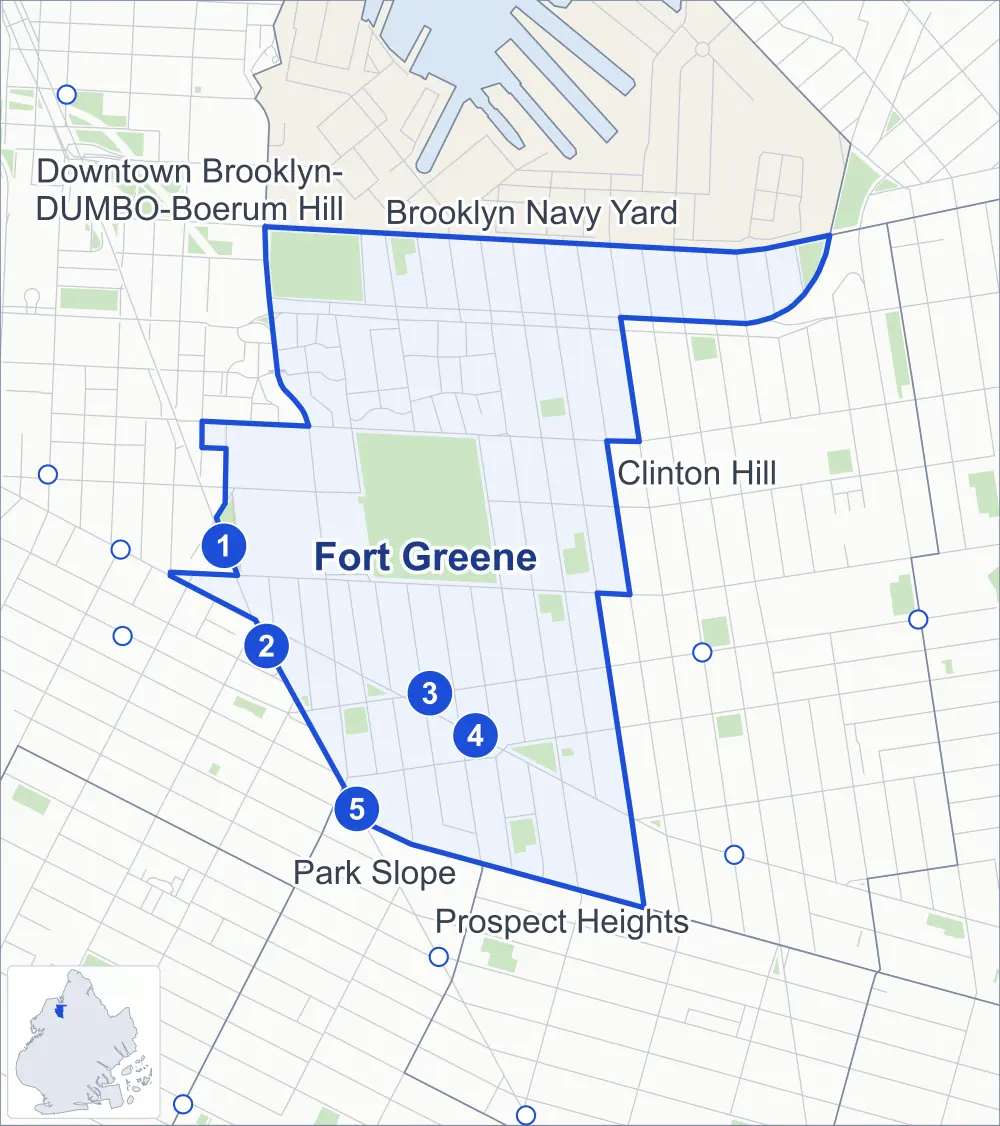
- Fort Greene
- A neighboring area
- Park
- A station in the list
- Another station
Neighborhood areas and streets: NYC Department of City Planning. Parks: NYC Parks. Stations: MTA.
Neighboring areas
- Brooklyn Navy Yard north
- Clinton Hill east
- Park Slope south
- Prospect Heights south
- Downtown Brooklyn-DUMBO-Boerum Hill west
Subway stations
- DeKalb Av lines B Q R accessible
- Nevins St lines 2 3 4 5
- Fulton St lines G
- Lafayette Av lines C
- Atlantic Av-Barclays Ctr lines 2 3 4 5 B Q accessible
Getting around
Five subway stations and buses on 14 routes stop in or at the edge of Fort Greene.
- 5 subway stations
- 2 of them listed by the MTA as fully accessible
- 14 local bus routes
Local bus routes
- B25
- B26
- B38
- B41
- B45
- B52
- B54
- B57
- B62
- B67
- B69
- B93
- B116
- T440
Safety record
Between 2021 and 2025, its corners averaged more police-reported crashes than the average Brooklyn corner.
- 1,517 police-reported crashes at its corners
- 12.9 a corner, on average
- 10.5 the average Brooklyn corner
- 11 corners with a clean record
Signal or safety changes on City record, at 45 of its corners
- Leading pedestrian intervals
- 29
- Accessible pedestrian signals
- 16
- Turn calming
- 7
- Barnes Dance all-way crossings
- 6
- Safety Improvement Projects
- 2
- Enhanced crossings
- 1
Camera tickets
In 2025 its corners had more school-zone speed camera tickets than red-light or bus-lane tickets.
- 1,624 red-light camera tickets at one corner
- 26,963 school-zone speed camera tickets at eight corners
- 156 bus-lane camera tickets at two corners
- Most red-light tickets
- Atlantic Avenue & Fort Greene Place, 1,624
- Most speed tickets
- Atlantic Avenue & Clermont Avenue, 10,502
- Most bus-lane tickets
- Fulton Street & St Felix Street, 87
People and homes
The 2020 Census counted 32,938 residents in Fort Greene, about 52,300 per square mile.
- 16,146 homes, 2020 Census
- 7,754 homes added since April 2010, net, by City Planning's count
Half of its 1,772 residential lots hold buildings from 1899 or earlier, and 80% of them date from before 1940, by the City's tax lot records.
NYCHA developments
NYCHA's Atlantic Terminal Site 4B, Whitman and Ingersoll developments lie wholly or partly within Fort Greene.
- Atlantic Terminal Site 4B
- Within Fort Greene
- Whitman
- Within Fort Greene
- Ingersoll
- Partly within Fort Greene
Parks and landmarks
- Parkland
- 49.4 acres of NYC Parks property
- The largest pieces
- Fort Greene Park (30.2 acres), Commodore Barry Park (10.1 acres) and Albert L. Parham Playground (1.3 acres)
- Designated landmarks
- The Hanson Place Baptist Church and the Paul Robeson Theatre
- Historic districts
- Brooklyn Academy of Music, Fort Greene and Wallabout, wholly or partly within Fort Greene
Streets and trees
- Trees
- 3,234 in NYC Parks' records, most often London planetree, thornless honeylocust and maidenhair tree
- Street with the most corners
- Fulton Street, with 15 of the area's 118
- Height above sea level
- From 10 feet at Navy Street & Concord Street to 87 feet at Lafayette Avenue & Adelphi Street
- Honorary street names
- 2 at its corners, enacted by local law
Schools and libraries
The City lists 15 schools and two libraries in Fort Greene.
- Public schools
- 9
- Charter and private schools
- 6
- Libraries
- Library for Arts & Culture and Walt Whitman Library
Bike share and public art
By the station list of October 3, 2026, 23 bike-share stations stand in Fort Greene. The City's public art inventory lists two works in the area: Prison Ship Martyrs Monument (1908) and Commodore John Barry (1996).
- 23 bike-share stations
- 2 works of public art
Public safety
How complaints are countedIn 2025 the NYPD recorded 378 major felonies at places in Fort Greene.
Recorded by the NYPD at places in Fort Greene
- 410 major felonies in 2024
- 1,533 other felonies, misdemeanors and violations in 2025
In 2025, on the streets along the edge of Fort Greene, the NYPD recorded another 301 major felonies.
- Police precincts
- 88th (most of the area), 78th, 84th
From January to June 2026 the NYPD recorded 157 major felonies at places in Fort Greene, against 201 in the same months of 2025.
Sources: the NYPD's Complaint Data Historic, updated April 28, 2026, and Complaint Data Current (Year To Date), updated July 27, 2026, on NYC Open Data. Figures to June 30, 2026.
Street corners
- Ashland Place & Brooklyn Hospital Center Driveway
- Ashland Place & Hanson Place
- Ashland Place & Willoughby Street
- Atlantic Avenue & 6th Avenue
- Atlantic Avenue & Clermont Avenue
- Atlantic Avenue & Cumberland Street
- Atlantic Avenue & Fort Greene Place
- Brooklyn-Queens Expressway & Adelphi Street
- Brooklyn-Queens Expressway & Clermont Avenue
- Brooklyn-Queens Expressway & Clinton Avenue
- Brooklyn-Queens Expressway & North Portland Avenue
- Brooklyn-Queens Expressway & St Edwards Street
- Brooklyn-Queens Expressway & Vanderbilt Avenue
- Carlton Avenue & Cumberland Walk
- Cumberland Street & Atlantic Commons
- Dekalb Avenue & Adelphi Street
- Dekalb Avenue & Ashland Place
- Dekalb Avenue & Brooklyn Hospital Center Driveway
- Dekalb Avenue & Carlton Avenue
- Dekalb Avenue & Clermont Avenue
- Dekalb Avenue & Fort Greene Place
- Dekalb Avenue & Hudson Avenue
- Dekalb Avenue & Rockwell Place
- Dekalb Avenue & South Elliott Place
- Dekalb Avenue & South Oxford Street
- Dekalb Avenue & South Portland Avenue
- Dekalb Avenue & St Felix Street
- Dekalb Avenue & Vanderbilt Avenue
- Dekalb Avenue & Washington Park
- Flatbush Avenue & Fulton Street
- Flatbush Avenue & Schermerhorn Street
- Fleet Street & University Plaza
- Flushing Avenue & Carlton Avenue
- Flushing Avenue & Clermont Avenue
- Flushing Avenue & Cumberland Street
- Flushing Avenue & Hall Street
- Flushing Avenue & Navy Street
- Flushing Avenue & North Portland Avenue
- Fort Greene Place & Hanson Place
- Fulton Street & Adelphi Street
- Fulton Street & Ashland Place
- Fulton Street & Carlton Avenue
- Fulton Street & Cumberland Street
- Fulton Street & Fort Greene Place
- Fulton Street & Greene Avenue
- Fulton Street & Hanover Place
- Fulton Street & Hudson Avenue
- Fulton Street & Lafayette Avenue
- Fulton Street & Rockwell Place
- Fulton Street & South Elliott Place
- Fulton Street & South Oxford Street
- Fulton Street & South Portland Avenue
- Fulton Street & St Felix Street
- Greene Avenue & Adelphi Street
- Greene Avenue & Carlton Avenue
- Greene Avenue & Cumberland Street
- Lafayette Avenue & Adelphi Street
- Lafayette Avenue & Ashland Place
- Lafayette Avenue & Carlton Avenue
- Lafayette Avenue & Cumberland Street
- Lafayette Avenue & Fort Greene Place
- Lafayette Avenue & Rockwell Place
- Lafayette Avenue & South Elliott Place
- Lafayette Avenue & South Oxford Street
- Lafayette Avenue & South Portland Avenue
- Lafayette Avenue & St Felix Street
- Myrtle Avenue & Adelphi Street
- Myrtle Avenue & Carlton Avenue
- Myrtle Avenue & Clermont Avenue
- Myrtle Avenue & Fleet Place
- Myrtle Avenue & Hudson Walk
- Myrtle Avenue & Monument Walk
- Myrtle Avenue & North Oxford Walk
- Myrtle Avenue & North Portland Avenue
- Myrtle Avenue & St Edwards Street
- Myrtle Avenue & Vanderbilt Avenue
- Myrtle Avenue & Washington Park
- Myrtle Avenue & Washington Walk
- Navy Street & Concord Street
- Navy Street & Navy Walk
- Navy Street & Tillary Street
- North Elliott Place & Auburn Place
- North Portland Avenue & Auburn Place
- North Portland Avenue & North Elliott Walk
- North Portland Avenue & North Oxford Walk
- Park Avenue & Adelphi Street
- Park Avenue & Carlton Avenue
- Park Avenue & Clermont Avenue
- Park Avenue & Cumberland Street
- Park Avenue & Cumberland Walk
- Park Avenue & Monument Walk
- Park Avenue & Navy Street
- Park Avenue & North Elliott Place
- Park Avenue & North Oxford Street
- Park Avenue & North Oxford Walk
- Park Avenue & North Portland Avenue
- Park Avenue & Vanderbilt Avenue
- Park Avenue & Waverly Avenue
- Park Avenue & Williamsburg Street West
- South Elliott Place & Hanson Place
- South Oxford Street & Atlantic Commons
- South Oxford Street & Hanson Place
- South Portland Avenue & Academy Park Place
- South Portland Avenue & Hanson Place
- St Edwards Street & Auburn Place
- St Edwards Street & Monument Walk
- St Edwards Street & North Elliott Walk
- St Felix Street & Hanson Place
- Washington Avenue & Flushing Avenue
- Williamsburg Street West & Brooklyn-Queens Expressway
- Willoughby Avenue & Adelphi Street
- Willoughby Avenue & Carlton Avenue
- Willoughby Avenue & Clermont Avenue
- Willoughby Avenue & Vanderbilt Avenue
- Willoughby Avenue & Washington Park
- Willoughby Street & Fleet Place
- Willoughby Street & Fleet Street
- Willoughby Street & St Edwards Street
How the figures above are measured: Methodology.