Downtown Brooklyn-DUMBO-Boerum Hill
Neighborhood · Brooklyn
This part of northwest Brooklyn joins Downtown Brooklyn, the civic and commercial center of the former City of Brooklyn, with DUMBO, Vinegar Hill and Boerum Hill.
- 0.85 square miles
- 40,968 residents, 2020 Census
- 219 street corners
- 10 subway stations
- 18 bus routes
Borough Hall, opened in 1848 as Brooklyn's Greek Revival City Hall, stands amid courthouses, colleges and the Fulton Mall shopping district. DUMBO, short for Down Under the Manhattan Bridge Overpass, is a former manufacturing center where artists began converting industrial buildings in the 1970s; part of it became a historic district in 2007. Boerum Hill, named for the Boerum family's colonial farm, is lined mostly with three-story rowhouses built between 1840 and 1870, and its historic district was designated in 1973.
Sources: Downtown Brooklyn (Wikipedia); Brooklyn Borough Hall (NYC Department of Citywide Administrative Services); Landmarks designates new DUMBO historic district (CityLand); Boerum Hill, Brooklyn (Wikipedia).
Downtown Brooklyn-DUMBO-Boerum Hill borders five areas, and Jay Street holds more of its corners than any other street, 18 of 219.
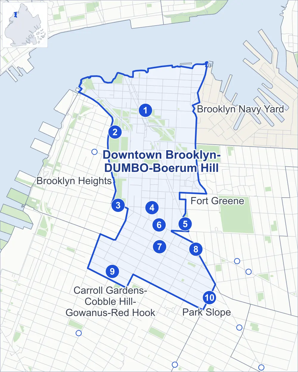
- Downtown Brooklyn-DUMBO-Boerum Hill
- A neighboring area
- Park
- A station in the list
- Another station
Neighborhood areas and streets: NYC Department of City Planning. Parks: NYC Parks. Stations: MTA.
Neighboring areas
- Brooklyn Navy Yard northeast
- Fort Greene southeast
- Park Slope southeast
- Carroll Gardens-Cobble Hill-Gowanus-Red Hook south
- Brooklyn Heights west
Subway stations
- York St lines F
- High St lines A C
- Borough Hall lines 2 3 4 5 accessible
- Jay St-MetroTech lines A C F R accessible
- DeKalb Av lines B Q R accessible
- Hoyt St lines 2 3
- Hoyt-Schermerhorn Sts lines A C G
- Nevins St lines 2 3 4 5
- Bergen St lines F G
- Atlantic Av-Barclays Ctr lines D N R accessible
Getting around
Ten subway stations and buses on 18 routes stop in or at the edge of Downtown Brooklyn-DUMBO-Boerum Hill.
- 10 subway stations
- 4 of them listed by the MTA as fully accessible
- 18 local bus routes
Local bus routes
- B25
- B26
- B37
- B38
- B41
- B45
- B52
- B54
- B57
- B61
- B62
- B63
- B65
- B67
- B69
- B93
- B103
- T440
Safety record
Between 2021 and 2025, its corners averaged more police-reported crashes than the average Brooklyn corner.
- 3,022 police-reported crashes at its corners
- 13.8 a corner, on average
- 10.5 the average Brooklyn corner
- 41 corners with a clean record
Signal or safety changes on City record, at 69 of its corners
- Leading pedestrian intervals
- 48
- Accessible pedestrian signals
- 40
- Turn calming
- 13
- Barnes Dance all-way crossings
- 8
- Safety Improvement Projects
- 5
- Enhanced crossings
- 2
Camera tickets
In 2025 its corners had more bus-lane camera tickets than school-zone speed or red-light tickets.
- 4,854 red-light camera tickets at two corners
- 9,968 school-zone speed camera tickets at seven corners
- 33,796 bus-lane camera tickets at six corners
- Most red-light tickets
- Tillary Street & Flatbush Avenue Extension, 2,524
- Most speed tickets
- Prospect Street & Cadman Plaza East, 3,287
- Most bus-lane tickets
- Fulton Street & Bond Street, 17,526
People and homes
The 2020 Census counted 40,968 residents in Downtown Brooklyn-DUMBO-Boerum Hill, about 48,200 per square mile.
- 21,352 homes, 2020 Census
- 14,853 homes added since April 2010, net, by City Planning's count
Half of its 1,511 residential lots hold buildings from 1900 or earlier, and 84% of them date from before 1940, by the City's tax lot records.
NYCHA developments
NYCHA's Farragut and Ingersoll developments lie wholly or partly within Downtown Brooklyn-DUMBO-Boerum Hill.
- Farragut
- Within Downtown Brooklyn-DUMBO-Boerum Hill
- Ingersoll
- Partly within Downtown Brooklyn-DUMBO-Boerum Hill
Parks and landmarks
- Parkland
- 34.3 acres of NYC Parks property
- The largest pieces
- Cadman Plaza Park (9.9 acres), Brooklyn Bridge Park (5.5 acres) and Columbus Park (5.4 acres)
- Designated landmarks
- The First Free Congregational Church, the Long Island Headquarters of the New York Telephone Company, the New York and New Jersey Telephone and Telegraph Building and the Offerman Building, among others
- Historic districts
- Boerum Hill, DUMBO and Fulton Ferry, wholly or partly within Downtown Brooklyn-DUMBO-Boerum Hill
Streets and trees
- Trees
- 3,686 in NYC Parks' records, most often London planetree, thornless honeylocust and maidenhair tree
- Street with the most corners
- Jay Street, with 18 of the area's 219
- Height above sea level
- From 6 feet at Water Street & Main Street to 83 feet at Cadman Plaza West & Clark Street
- Honorary street names
- 9 at its corners, enacted by local law
Schools and libraries
The City lists 37 schools and two libraries in Downtown Brooklyn-DUMBO-Boerum Hill.
- Public schools
- 20
- Charter and private schools
- 17
- Libraries
- Adams Street Library and Teen Tech Center at the Annex
Bike share and public art
By the station list of October 3, 2026, 27 bike-share stations stand in Downtown Brooklyn-DUMBO-Boerum Hill. The City's public art inventory lists ten works in the area, among them Henry Ward Beecher Monument (1891), McLaughlin Park World War I Memorial (1919) and William Jay Gaynor Memorial (1926).
- 27 bike-share stations
- 10 works of public art
Public safety
How complaints are countedIn 2025 the NYPD recorded 1,099 major felonies at places in Downtown Brooklyn-DUMBO-Boerum Hill.
Recorded by the NYPD at places in Downtown Brooklyn-DUMBO-Boerum Hill
- 1,187 major felonies in 2024
- 3,648 other felonies, misdemeanors and violations in 2025
In 2025, on the streets along the edge of Downtown Brooklyn-DUMBO-Boerum Hill, the NYPD recorded another 238 major felonies. Counting the streets along its edge, in 2025 the NYPD recorded 32.6 major felonies for every thousand residents the 2020 Census counted in Downtown Brooklyn-DUMBO-Boerum Hill.
- Police precincts
- 84th (most of the area), 88th
From January to June 2026 the NYPD recorded 392 major felonies at places in Downtown Brooklyn-DUMBO-Boerum Hill, against 496 in the same months of 2025.
Sources: the NYPD's Complaint Data Historic, updated April 28, 2026, and Complaint Data Current (Year To Date), updated July 27, 2026, on NYC Open Data. Figures to June 30, 2026.
Street corners
- 1st Avenue & Navy Street
- 3rd Avenue & Dean Street
- 3rd Avenue & Lafayette Avenue
- 3rd Avenue & Pacific Street
- 3rd Avenue & State Street
- 4th Avenue & Dean Street
- Adams Street & Brooklyn Bridge
- Adams Street & Brooklyn Bridge Bike Path
- Adams Street & Brooklyn Bridge Pedestrian and Bike Path
- Adams Street & Brooklyn Bridge Pedestrian Path (north)
- Adams Street & Brooklyn Bridge Pedestrian Path (south)
- Adams Street & Brooklyn Bridge Pedestrian Path at Brooklyn Bridge Pedestrian and Bike Path
- Adams Street & Front Street
- Adams Street & John Street
- Adams Street & Plymouth Street
- Adams Street & Prospect Street
- Adams Street & Tillary Street
- Adams Street & York Street
- Atlantic Avenue & 3rd Avenue
- Atlantic Avenue & Bond Street
- Atlantic Avenue & Court Street
- Atlantic Avenue & Hoyt Street
- Atlantic Avenue & Nevins Street
- Atlantic Avenue & Smith Street
- Bergen Street & 3rd Avenue
- Bergen Street & Boerum Place
- Bergen Street & Bond Street
- Bergen Street & Court Street
- Bergen Street & Nevins Street
- Bergen Street & Smith Street
- Bond Street & Livingston Street
- Bond Street & Schermerhorn Street
- Bridge Street & Cathedral Place
- Bridge Street & Concord Street
- Bridge Street & Front Street
- Bridge Street & John Street
- Bridge Street & Metrotech Roadway
- Bridge Street & Metrotech Walk
- Bridge Street & Nassau Street
- Bridge Street & Plymouth Street
- Bridge Street & Tech Place
- Bridge Street & Water Street
- Bridge Street & Willoughby Street
- Bridge Street & York Street
- Brooklyn Bridge & Cadman Plaza East
- Brooklyn-Queens Expressway & Adams Street
- Brooklyn-Queens Expressway & Concord Street
- Brooklyn-Queens Expressway & Jay Street
- Brooklyn-Queens Expressway & Manhattan Bridge
- Brooklyn-Queens Expressway & Manhattan Bridge Bike Path
- Brooklyn-Queens Expressway & Manhattan Bridge Pedestrian Path
- Brooklyn-Queens Expressway & Navy Street
- Brooklyn-Queens Expressway & Old Fulton Street
- Brooklyn-Queens Expressway & Pearl Street
- Brooklyn-Queens Expressway & Prospect Street
- Brooklyn-Queens Expressway & Sands Street
- Brooklyn-Queens Expressway & Tillary Street
- Brooklyn-Queens Expressway & Washington Street
- Cadman Plaza East & Brooklyn Bridge Pedestrian Path
- Cadman Plaza East & Red Cross Place
- Cadman Plaza West & Clark Street
- Cadman Plaza West & Johnson Street
- Cadman Plaza West & Prospect Street
- Concord Street & Bridge Plaza Court
- Concord Street & Prince Street
- Court Street & Congress Street
- Court Street & Warren Street
- Court Street & Wyckoff Street
- Dean Street & Boerum Place
- Dean Street & Bond Street
- Dean Street & Hoyt Street
- Dean Street & Nevins Street
- Dean Street & Smith Street
- Dekalb Avenue & Flatbush Avenue Extension
- Duffield Street & Concord Street
- Duffield Street & Metrotech Roadway
- Duffield Street & Nassau Street
- Duffield Street & Tech Place
- Evans Street & Harrison Alley
- Flatbush Avenue & 3rd Avenue
- Flatbush Avenue & 4th Avenue
- Flatbush Avenue & Lafayette Avenue
- Flatbush Avenue & Livingston Street
- Flatbush Avenue & State Street
- Flatbush Avenue Extension & Fleet Street
- Fleet Street & Fleet Place
- Fleet Walk & Hudson Walk
- Front Street & Brooklyn Bridge
- Front Street & Hudson Avenue
- Front Street & Main Street
- Front Street & Pearl Street
- Front Street & Washington Street
- Front Street & York Street
- Fulton Street & Albee Square
- Fulton Street & Bond Street
- Fulton Street & Bridge Street
- Fulton Street & Duffield Street
- Fulton Street & Elm Place
- Fulton Street & Gallatin Place
- Fulton Street & Hoyt Street
- Fulton Street & Lawrence Street
- Fulton Street & Pearl Street
- Fulton Street & Smith Street
- Gold Street & Bike Path
- Gold Street & Concord Street
- Gold Street & Front Street
- Gold Street & John Street
- Gold Street & Johnson Street
- Gold Street & Marshall Street
- Gold Street & Plymouth Street
- Gold Street & Sands Street
- Gold Street & Tillary Street
- Gold Street & Water Street
- Gold Street & Willoughby Street
- Gold Street & York Street
- Hanover Place & Grove Place
- Hoyt Street & Livingston Street
- Hoyt Street & Schermerhorn Street
- Hudson Avenue & Evans Street
- Hudson Avenue & Marshall Street
- Jay Street & Cathedral Place
- Jay Street & Chapel Street
- Jay Street & Concord Street
- Jay Street & Front Street
- Jay Street & John Street
- Jay Street & Johnson Street
- Jay Street & Manhattan Bridge
- Jay Street & Manhattan Bridge Pedestrian Path
- Jay Street & Metrotech Roadway
- Jay Street & Nassau Street
- Jay Street & Plymouth Street
- Jay Street & Tillary Street
- Jay Street & Water Street
- Jay Street & Willoughby Street
- Jay Street & York Street
- John Street & Hudson Avenue
- John Street & Little Street
- Johnson Street & Cadman Plaza East
- Johnson Street & Fleet Walk
- Johnson Street & Hudson Walk
- Johnson Street & Navy Walk
- Johnson Street & Prince Street
- Lawrence Street & Metrotech Roadway
- Lawrence Street & Metrotech Walk
- Lawrence Street & Tech Place
- Livingston Street & Elm Place
- Livingston Street & Gallatin Place
- Livingston Street & Hanover Place
- Main Street & Howard Alley
- Manhattan Bridge & Adams Street
- Manhattan Bridge & Manhattan Bridge Pedestrian Path
- Manhattan Bridge & Nassau Street
- Myrtle Avenue & Bridge Street
- Myrtle Avenue & Flatbush Avenue Extension
- Myrtle Avenue & Gold Street
- Myrtle Avenue & Jay Street
- Myrtle Avenue & Lawrence Street
- Myrtle Avenue & Navy Street
- Myrtle Avenue & Navy Walk
- Myrtle Avenue & Prince Street
- Navy Street & Monument Walk
- Navy Street & Sands Street
- Navy Street & York Street
- Navy Walk & Fleet Walk
- Navy Walk & Hudson Walk
- Nevins Street & Livingston Street
- Old Fulton Street & Elizabeth Place
- Old Fulton Street & Everit Street
- Pacific Street & Boerum Place
- Pacific Street & Bond Street
- Pacific Street & Hoyt Street
- Pacific Street & Nevins Street
- Pacific Street & Smith Street
- Park Avenue & Navy Street at Tillary Street
- Pearl Street & Anchorage Place
- Pearl Street & High Street
- Pearl Street & John Street
- Pearl Street & Prospect Street
- Plymouth Street & Anchorage Place
- Plymouth Street & Hudson Avenue
- Plymouth Street & Little Street
- Plymouth Street & Main Street
- Plymouth Street & Pearl Street
- Plymouth Street & Washington Street
- Prince Street & Fleet Walk
- Prospect Street & Cadman Plaza East
- Sands Street & Brooklyn Bridge
- Sands Street & Brooklyn-Queens Expressway
- Sands Street & Manhattan Bridge Bike Path
- Sands Street & Pearl Street
- Schermerhorn Street & Nevins Street
- Smith Street & Livingston Street
- Smith Street & Schermerhorn Street
- Smith Street & State Street
- Smith Street & Warren Street
- Smith Street & Wyckoff Street
- State Street & Bond Street
- State Street & Hoyt Street
- State Street & Nevins Street
- Tillary Street & Brooklyn-Queens Expressway
- Tillary Street & Brooklyn-Queens Expressway (Exit 29)
- Tillary Street & Cadman Plaza East
- Tillary Street & Flatbush Avenue Extension
- Tillary Street & Fleet Walk
- Water Street & Adams Street
- Water Street & Anchorage Place
- Water Street & Dock Street
- Water Street & Hudson Avenue
- Water Street & Main Street
- Water Street & New Dock Street
- Water Street & Pearl Street
- Water Street & Washington Street
- Willoughby Street & Duffield Street
- Willoughby Street & Flatbush Avenue Extension
- Willoughby Street & Lawrence Street
- Willoughby Street & Pearl Street
- York Street & Fleet Alley
- York Street & Pearl Street
- York Street & Washington Street
How the figures above are measured: Methodology.