Carroll Gardens-Cobble Hill-Gowanus-Red Hook
Neighborhood · Brooklyn
Spanning the Gowanus Canal and the Red Hook waterfront, this area joins Cobble Hill, Carroll Gardens, Gowanus and Red Hook.
- 2.18 square miles
- 59,166 residents, 2020 Census
- 403 street corners
- 5 subway stations
- 6 bus routes
Red Hook, once known as Roode Hoek for the color of its soil and the outline of its shore, grew into a shipping center after the Atlantic Basin opened in the 1840s, and the Gowanus Canal, authorized in 1849, drew more than 30 industrial firms by 1880. Carroll Gardens, counted as part of Red Hook until the mid-1960s, has rows of brownstones behind deep front yards laid out on an 1846 map, and Cobble Hill was named in 1776 by Continental soldiers after a hill they had fortified near Boston.
Sources: Coffey Park History (NYC Parks); Gowanus Canal Flushing Tunnel Pumping Station and Gate House (NYC Landmarks Preservation Commission); Carroll Gardens Historic District Designation Report (NYC Landmarks Preservation Commission); Cobble Hill Park History (NYC Parks).
Carroll Gardens-Cobble Hill-Gowanus-Red Hook borders six areas, and Columbia Street and Hicks Street hold more of its corners than any other street, 31 each of 403.
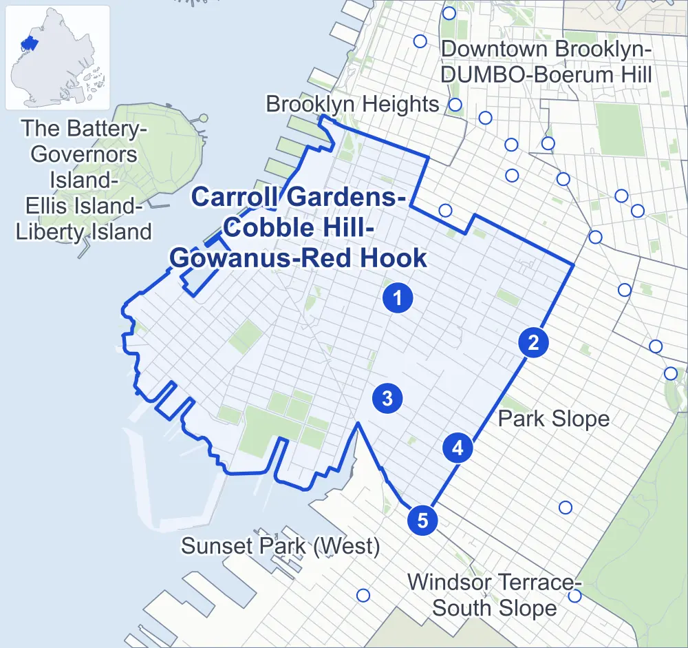
- Carroll Gardens-Cobble Hill-Gowanus-Red Hook
- A neighboring area
- Park
- A station in the list
- Another station
Neighborhood areas and streets: NYC Department of City Planning. Parks: NYC Parks. Stations: MTA.
Neighboring areas
- Brooklyn Heights north
- Downtown Brooklyn-DUMBO-Boerum Hill northeast
- Park Slope east
- Windsor Terrace-South Slope southeast
- Sunset Park (West) south
- The Battery-Governors Island-Ellis Island-Liberty Island northwest
Subway stations
- Carroll St lines F G
- Union St lines R
- Smith-9 Sts lines F G
- 4 Av-9 St lines F G R
- Prospect Av lines R
Getting around
Five subway stations and buses on six routes stop in or at the edge of Carroll Gardens-Cobble Hill-Gowanus-Red Hook.
- 5 subway stations
- 6 local bus routes
Local bus routes
- B37
- B57
- B61
- B63
- B65
- B103
Safety record
Between 2021 and 2025, its corners averaged fewer police-reported crashes than the average Brooklyn corner.
- 2,864 police-reported crashes at its corners
- 7.1 a corner, on average
- 10.5 the average Brooklyn corner
- 56 corners with a clean record
Signal or safety changes on City record, at 80 of its corners
- Leading pedestrian intervals
- 64
- Accessible pedestrian signals
- 22
- Turn calming
- 5
- Enhanced crossings
- 5
- Barnes Dance all-way crossings
- 3
- Safety Improvement Projects
- 3
Camera tickets
In 2025 its corners had more school-zone speed camera tickets than red-light or bus-lane tickets.
- 4,604 red-light camera tickets at one corner
- 41,418 school-zone speed camera tickets at nine corners
- 0 bus-lane camera tickets
- Most red-light tickets
- Gowanus Expressway & Clinton Street, 4,604
- Most speed tickets
- Gowanus Expressway & Hamilton Avenue at Bush Street, 33,206
People and homes
The 2020 Census counted 59,166 residents in Carroll Gardens-Cobble Hill-Gowanus-Red Hook, about 27,100 per square mile.
- 27,657 homes, 2020 Census
- 5,819 homes added since April 2010, net, by City Planning's count
Half of its 5,854 residential lots hold buildings from 1900 or earlier, and 90% of them date from before 1940, by the City's tax lot records.
NYCHA developments
NYCHA's Gowanus, Red Hook East, Red Hook West and Wyckoff Gardens developments lie wholly or partly within Carroll Gardens-Cobble Hill-Gowanus-Red Hook.
Parks and landmarks
- Parkland
- 73.5 acres of NYC Parks property
- The largest pieces
- Red Hook Recreation Area (46.2 acres), Coffey Park (8.2 acres) and Van Voorhees Playground (4 acres)
- Designated landmarks
- The Brooklyn Clay Retort and Fire Brick Works Storehouse, the Hans S. Christian Memorial Kindergarten, 238 President Street House and the Brooklyn Rapid Transit Company (BRT) Central Power Station, among others
- Historic districts
- Boerum Hill, Carroll Gardens, Cobble Hill and Cobble Hill Extension, wholly or partly within Carroll Gardens-Cobble Hill-Gowanus-Red Hook
Streets and trees
- Trees
- 7,391 in NYC Parks' records, most often London planetree, thornless honeylocust and pin oak
- Street with the most corners
- Columbia Street, with 31 of the area's 403
- Height above sea level
- From 4 feet at Sullivan Street & Ferris Street to 63 feet at Court Street & 1st Place
- Honorary street names
- 15 at its corners, enacted by local law
Schools and libraries
The City lists 23 schools and two libraries in Carroll Gardens-Cobble Hill-Gowanus-Red Hook.
- Public schools
- 13
- Charter and private schools
- 10
- Libraries
- Carroll Gardens Pop-Up Library and Red Hook Pop-Up Library
Bike share and public art
By the station list of October 3, 2026, 56 bike-share stations stand in Carroll Gardens-Cobble Hill-Gowanus-Red Hook. The City's public art inventory lists three works in the area: Carroll Park Memorial (1921), Assent Ascent (2009) and Timecast (2012).
- 56 bike-share stations
- 3 works of public art
Public safety
How complaints are countedIn 2025 the NYPD recorded 600 major felonies at places in Carroll Gardens-Cobble Hill-Gowanus-Red Hook.
Recorded by the NYPD at places in Carroll Gardens-Cobble Hill-Gowanus-Red Hook
- 639 major felonies in 2024
- 2,799 other felonies, misdemeanors and violations in 2025
In 2025, on the streets along the edge of Carroll Gardens-Cobble Hill-Gowanus-Red Hook, the NYPD recorded another 112 major felonies. Counting the streets along its edge, in 2025 the NYPD recorded 12.0 major felonies for every thousand residents the 2020 Census counted in Carroll Gardens-Cobble Hill-Gowanus-Red Hook.
- Police precincts
- 76th (most of the area), 78th, 84th, 72nd
From January to June 2026 the NYPD recorded 282 major felonies at places in Carroll Gardens-Cobble Hill-Gowanus-Red Hook, against 261 in the same months of 2025.
Sources: the NYPD's Complaint Data Historic, updated April 28, 2026, and Complaint Data Current (Year To Date), updated July 27, 2026, on NYC Open Data. Figures to June 30, 2026.
Street corners
- 1st Street & Bond Street
- 1st Street & Denton Place
- 1st Street & Gowanus Promenade West
- 1st Street & Hoyt Street
- 1st Street & Whitwell Place
- 2nd Avenue & 5th Street
- 2nd Avenue & 6th Street
- 2nd Avenue & 7th Street
- 2nd Avenue & 8th Street
- 2nd Avenue & 9th Street
- 2nd Avenue & 10th Street
- 2nd Avenue & 11th Street
- 2nd Avenue & 12th Street
- 2nd Avenue & 13th Street
- 2nd Avenue & 14th Street
- 2nd Avenue & 15th Street
- 2nd Street & Bond Street
- 2nd Street & Gowanus Promenade West
- 2nd Street & Hoyt Street
- 2nd Street & Smith Street
- 3rd Avenue & 1st Street
- 3rd Avenue & 2nd Street
- 3rd Avenue & 3rd Street
- 3rd Avenue & 6th Street
- 3rd Avenue & 7th Street
- 3rd Avenue & 8th Street
- 3rd Avenue & 9th Street
- 3rd Avenue & 10th Street
- 3rd Avenue & 11th Street
- 3rd Avenue & 12th Street
- 3rd Avenue & 13th Street
- 3rd Avenue & 14th Street
- 3rd Avenue & 15th Street
- 3rd Avenue & 16th Street
- 3rd Avenue & Baltic Street
- 3rd Avenue & Butler Street
- 3rd Avenue & Carroll Street
- 3rd Avenue & Degraw Street
- 3rd Avenue & Douglass Street
- 3rd Avenue & President Street
- 3rd Avenue & Sackett Street
- 3rd Avenue & Union Street
- 3rd Avenue & Warren Street
- 3rd Avenue & Wyckoff Street
- 3rd Street & Bond Street
- 3rd Street & Hoyt Street
- 3rd Street Bridge & 3rd Street
- 4th Avenue & 8th Street
- 4th Avenue & 9th Street
- 4th Avenue & 10th Street
- 4th Avenue & 11th Street
- 4th Avenue & 12th Street
- 4th Avenue & 15th Street
- 4th Avenue & 16th Street
- 4th Avenue & Butler Street
- 4th Avenue & Degraw Street
- 4th Avenue & Sackett Street
- 4th Avenue & St Marks Place
- 4th Avenue & Warren Street
- 4th Street & Bond Street
- 4th Street & Hoyt Street
- 5th Street & Smith Street
- 9th Street & Smith Street
- 9th Street Bridge & 9th Street
- 12th Street & Hamilton Place
- 13th Street & Hamilton Place
- 14th Street & Hamilton Place
- Atlantic Avenue & Bridge Park Drive
- Atlantic Avenue & Brooklyn-Queens Expressway
- Atlantic Avenue & Clinton Street
- Atlantic Avenue & Henry Street
- Atlantic Avenue & Hicks Street
- Baltic Street & Bond Street
- Baltic Street & Hoyt Street
- Baltic Street & Nevins Street
- Baltic Street & Warren Place
- Bay Street & Otsego Street
- Beard Street & Conover Street
- Beard Street & Dwight Street
- Beard Street & Halleck Street
- Beard Street & Ikea Bus Terminal Driveway
- Bergen Street & 4th Avenue
- Bergen Street & Hoyt Street
- Bond Street & Butler Street
- Bond Street & Douglass Street
- Bond Street & Warren Street
- Bond Street & Wyckoff Street
- Brooklyn-Battery Tunnel & Columbia Street
- Brooklyn-Battery Tunnel & Hamilton Avenue at Bowne Street
- Brooklyn-Battery Tunnel & Hamilton Avenue at Brooklyn-Queens Expressway
- Brooklyn-Battery Tunnel & Hamilton Avenue at Coles Street
- Brooklyn-Battery Tunnel & Hamilton Avenue at Rapelye Street
- Brooklyn-Battery Tunnel & Hamilton Avenue at Van Brunt Street
- Brooklyn-Battery Tunnel & Hamilton Avenue at Woodhull Street
- Brooklyn-Battery Tunnel & Hicks Street at Hamilton Avenue
- Brooklyn-Battery Tunnel & Hicks Street at Hamilton Avenue (Hamilton Avenue)
- Brooklyn-Battery Tunnel & Summit Street
- Brooklyn-Queens Expressway & Bowne Street
- Brooklyn-Queens Expressway & Coles Street (east)
- Brooklyn-Queens Expressway & Coles Street (west)
- Brooklyn-Queens Expressway & Congress Street
- Brooklyn-Queens Expressway & Kane Street
- Brooklyn-Queens Expressway & Rapelye Street
- Brooklyn-Queens Expressway & Sackett Street
- Brooklyn-Queens Expressway & Union Street
- Carroll Street & Bond Street
- Carroll Street & Clinton Street
- Carroll Street & Columbia Street
- Carroll Street & Court Street
- Carroll Street & Denton Place
- Carroll Street & Gowanus Promenade West
- Carroll Street & Henry Street
- Carroll Street & Hicks Street
- Carroll Street & Hoyt Street
- Carroll Street & Nevins Street
- Carroll Street & Smith Street
- Carroll Street & Van Brunt Street
- Carroll Street & Whitwell Place
- Carroll Street Bridge & Carroll Street
- Clinton Street & 1st Place
- Clinton Street & 2nd Place
- Clinton Street & 3rd Place
- Clinton Street & 4th Place
- Clinton Street & Amity Street
- Clinton Street & Baltic Street
- Clinton Street & Bay Street
- Clinton Street & Bryant Street
- Clinton Street & Bush Street
- Clinton Street & Centre Street
- Clinton Street & Congress Street
- Clinton Street & Degraw Street
- Clinton Street & Halleck Street
- Clinton Street & Huntington Street
- Clinton Street & Kane Street
- Clinton Street & Lorraine Street
- Clinton Street & Luquer Street
- Clinton Street & Mill Street
- Clinton Street & Nelson Street
- Clinton Street & Sackett Street
- Clinton Street & Verandah Place
- Clinton Street & Warren Street
- Clinton Wharf & Ferris Street
- Coffey Street & Conover Street
- Coffey Street & Dwight Street
- Coffey Street & Ferris Street
- Coffey Street & Otsego Street
- Coles Street & Pedestrian Overpass
- Columbia Street & Baltic Street
- Columbia Street & Bay Street
- Columbia Street & Brooklyn-Queens Expressway (Columbia Street)
- Columbia Street & Brooklyn-Queens Expressway (Exit 27)
- Columbia Street & Brooklyn-Queens Expressway (Hamilton Avenue)
- Columbia Street & Bush Street
- Columbia Street & Centre Mall
- Columbia Street & Columbia Street Esplanade
- Columbia Street & Commerce Street
- Columbia Street & Congress Street
- Columbia Street & Creamer Street
- Columbia Street & Degraw Street
- Columbia Street & Dwight Street
- Columbia Street & Huntington Street
- Columbia Street & Kane Street
- Columbia Street & Lorraine Street
- Columbia Street & Luquer Street
- Columbia Street & Mill Street
- Columbia Street & Nelson Street
- Columbia Street & Sackett Street
- Columbia Street & Seabring Street
- Columbia Street & Sigourney Street
- Columbia Street & Summit Street
- Columbia Street & Verona Street
- Columbia Street & Warren Street
- Columbia Street & West 9th Street
- Columbia Street & Woodhull Street
- Commercial Wharf & Bowne Street
- Commercial Wharf & Commerce Street
- Commercial Wharf & Verona Street
- Conover Street & King Street
- Conover Street & Reed Street
- Conover Street & Sullivan Street
- Court Street & 1st Place
- Court Street & 2nd Place
- Court Street & 3rd Place
- Court Street & 4th Place
- Court Street & Amity Street
- Court Street & Baltic Street
- Court Street & Bay Street
- Court Street & Bryant Street
- Court Street & Bush Street
- Court Street & Butler Street
- Court Street & Creamer Street
- Court Street & Degraw Street
- Court Street & Douglass Street
- Court Street & Garnet Street
- Court Street & Halleck Street
- Court Street & Huntington Street
- Court Street & Kane Street
- Court Street & Lorraine Street
- Court Street & Luquer Street
- Court Street & Nelson Street
- Court Street & Sackett Street
- Court Street & Sigourney Street
- Creamer Street & Otsego Street
- Dean Street & Court Street
- Degraw Street & Bond Street
- Degraw Street & Cheever Place
- Degraw Street & Hoyt Street
- Degraw Street & Nevins Street
- Degraw Street & Strong Place
- Degraw Street & Tiffany Place
- Degraw Street & Tompkins Place
- Dikeman Street & Conover Street
- Dikeman Street & Ferris Street
- Dikeman Street & Otsego Street
- Douglass Street & Hoyt Street
- Douglass Street & Nevins Street
- Dwight Street & Delavan Street
- Dwight Street & Dikeman Street
- Dwight Street & Otsego Street
- Dwight Street & Otsego Street at Bush Street
- Dwight Street & Pioneer Street
- Dwight Street & Verona Street
- Dwight Street & Wolcott Street
- Ferris Street & King Street
- Gowanus Expressway & Brooklyn-Battery Tunnel at Hamilton Avenue (Hamilton Avenue)
- Gowanus Expressway & Brooklyn-Battery Tunnel at Hamilton Avenue (north-west)
- Gowanus Expressway & Brooklyn-Battery Tunnel at Hamilton Avenue (south-east)
- Gowanus Expressway & Brooklyn-Battery Tunnel at Hicks Street
- Gowanus Expressway & Brooklyn-Queens Expressway
- Gowanus Expressway & Clinton Street
- Gowanus Expressway & Court Street
- Gowanus Expressway & Hamilton Avenue at Bush Street
- Gowanus Expressway & Hamilton Avenue at Centre Street
- Gowanus Expressway & Hamilton Avenue at Huntington Street
- Gowanus Expressway & Hamilton Avenue at Lorraine Street
- Gowanus Expressway & Hamilton Avenue at Luquer Street
- Gowanus Expressway & Hamilton Avenue at Nelson Street
- Gowanus Expressway & Henry Street
- Gowanus Expressway & Huntington Street
- Gowanus Expressway & West 9th Street
- Halleck Street & Ikea Bus Terminal Driveway
- Hamilton Avenue & 16th Street
- Hamilton Avenue & Prospect Expressway
- Henry Street & 1st Place
- Henry Street & 2nd Place
- Henry Street & 3rd Place
- Henry Street & 4th Place
- Henry Street & Amity Street
- Henry Street & Baltic Street
- Henry Street & Bay Street
- Henry Street & Brooklyn-Queens Expressway
- Henry Street & Bush Street
- Henry Street & Centre Mall
- Henry Street & Coles Street
- Henry Street & Congress Street
- Henry Street & Degraw Street
- Henry Street & Huntington Street
- Henry Street & Kane Street
- Henry Street & Lorraine Street
- Henry Street & Mill Street
- Henry Street & Rapelye Street
- Henry Street & Sackett Street
- Henry Street & Summit Street
- Henry Street & Verandah Place
- Henry Street & Warren Street
- Henry Street & West 9th Street
- Henry Street & Woodhull Street
- Hicks Street & Amity Street
- Hicks Street & Baltic Street
- Hicks Street & Bay Street
- Hicks Street & Brooklyn-Battery Tunnel
- Hicks Street & Brooklyn-Queens Expressway
- Hicks Street & Brooklyn-Queens Expressway at Woodhull Street
- Hicks Street & Bush Street
- Hicks Street & Centre Mall
- Hicks Street & Congress Street
- Hicks Street & Creamer Street
- Hicks Street & Degraw Street
- Hicks Street & Huntington Street
- Hicks Street & Kane Street
- Hicks Street & Lorraine Street
- Hicks Street & Luquer Street
- Hicks Street & Mill Street
- Hicks Street & Nelson Street
- Hicks Street & Rapelye Street
- Hicks Street & Sackett Street
- Hicks Street & Summit Street
- Hicks Street & Warren Street
- Hicks Street & West 9th Street
- Hicks Street & Woodhull Street
- Hoyt Street & Butler Street
- Hoyt Street & Warren Street
- Imlay Street & Bowne Street
- Imlay Street & Commerce Street
- Imlay Street & Pioneer Street
- Kane Street & Cheever Place
- Kane Street & Strong Place
- Kane Street & Tiffany Place
- Kane Street & Tompkins Place
- Lorraine Street & Wolcott Street
- Luquer Street & Brooklyn Battery Tunnel
- Luquer Street & Brooklyn-Queens Expressway
- Luquer Street & Dennett Place
- Nelson Street & Brooklyn Battery Tunnel
- Nelson Street & Brooklyn-Queens Expressway
- Nelson Street & Dennett Place
- Nevins Street & Butler Street
- Pacific Street & Clinton Street
- Pacific Street & Court Street
- Pacific Street & Henry Street
- Pacific Street & Hicks Street
- President Street & Bond Street
- President Street & Clinton Street
- President Street & Columbia Street
- President Street & Court Street
- President Street & Henry Street
- President Street & Hicks Street
- President Street & Hoyt Street
- President Street & Nevins Street
- President Street & Smith Street
- President Street & Van Brunt Street
- Richards Street & Beard Street
- Richards Street & Bowne Street
- Richards Street & Coffey Street
- Richards Street & Commerce Street
- Richards Street & Delavan Street
- Richards Street & Dikeman Street
- Richards Street & King Street
- Richards Street & Pioneer Street
- Richards Street & Seabring Street
- Richards Street & Sullivan Street
- Richards Street & Van Dyke Street
- Richards Street & Verona Street
- Richards Street & Visitation Place
- Richards Street & Wolcott Street
- Sackett Street & Bond Street
- Sackett Street & Gowanus Promenade West
- Sackett Street & Hoyt Street
- Sackett Street & Nevins Street
- Sackett Street & Van Brunt Street
- Sigourney Street & Otsego Street
- Smith Street & 1st Place
- Smith Street & 2nd Place
- Smith Street & 3rd Street
- Smith Street & 4th Street
- Smith Street & Baltic Street
- Smith Street & Bay Street
- Smith Street & Bush Street
- Smith Street & Butler Street
- Smith Street & Centre Street
- Smith Street & Creamer Street
- Smith Street & Degraw Street
- Smith Street & Douglass Street
- Smith Street & Garnet Street
- Smith Street & Halleck Street
- Smith Street & Huntington Street
- Smith Street & Lorraine Street
- Smith Street & Luquer Street
- Smith Street & Nelson Street
- Smith Street & Sackett Street
- Smith Street & Sigourney Street
- Sullivan Street & Ferris Street
- Union Street & Bond Street
- Union Street & Clinton Street
- Union Street & Columbia Street
- Union Street & Court Street
- Union Street & Gowanus Promenade West
- Union Street & Henry Street
- Union Street & Hicks Street
- Union Street & Hoyt Street
- Union Street & Nevins Street
- Union Street & Smith Street
- Union Street & Van Brunt Street
- Union Street Bridge & Union Street
- Van Brunt Street & Beard Street
- Van Brunt Street & Bowne Street
- Van Brunt Street & Coffey Street
- Van Brunt Street & Commerce Street
- Van Brunt Street & Delavan Street
- Van Brunt Street & Dikeman Street
- Van Brunt Street & King Street
- Van Brunt Street & Pioneer Street
- Van Brunt Street & Reed Street
- Van Brunt Street & Seabring Street
- Van Brunt Street & Sullivan Street
- Van Brunt Street & Summit Street
- Van Brunt Street & Van Dyke Street
- Van Brunt Street & Verona Street
- Van Brunt Street & Visitation Place
- Van Brunt Street & Wolcott Street
- Van Dyke Street & Barnell Street
- Van Dyke Street & Conover Street
- Van Dyke Street & Dwight Street
- Van Dyke Street & Ferris Street
- Van Dyke Street & Otsego Street
- Verona Street & Imlay Street
- Warren Street & Nevins Street
- Warren Street & Warren Place
- West 9th Street & Court Street
- Wolcott Street & Conover Street
- Wolcott Street & Ferris Street
- Wyckoff Street & Hoyt Street
- Wyckoff Street & Nevins Street
How the figures above are measured: Methodology.