Sunset Park (West)
Neighborhood · Brooklyn
Sunset Park (West) covers the waterfront side of Sunset Park, a neighborhood whose name in the 1960s came to cover everything from 17th to 65th Streets.
- 1.81 square miles
- 54,473 residents, 2020 Census
- 215 street corners
- 6 subway stations
- 10 bus routes
Beginning in the 1890s its shoreline was remade by Bush Terminal, a complex of piers, warehouses and factories that reached from 32nd to 51st Streets and employed 20,000 people, while rowhouses went up inland for port workers. The Brooklyn Army Terminal, built in 1918 and once the largest military supply base in the country, was bought by the City in 1981 and now holds manufacturing space, and Bush Terminal Piers Park opened on the shoreline in 2014.
Sources: Firehouse, Engine Company 28 (now Engine Company 228) (NYC Landmarks Preservation Commission); LPC Designates Four Historic Districts in Sunset Park (NYC Landmarks Preservation Commission); About Us (Brooklyn Army Terminal); Sunset Park: Irving's Place (NYC Municipal Archives).
Sunset Park (West) borders five areas, and Gowanus Expressway holds more of its corners than any other street, 59 of 215.
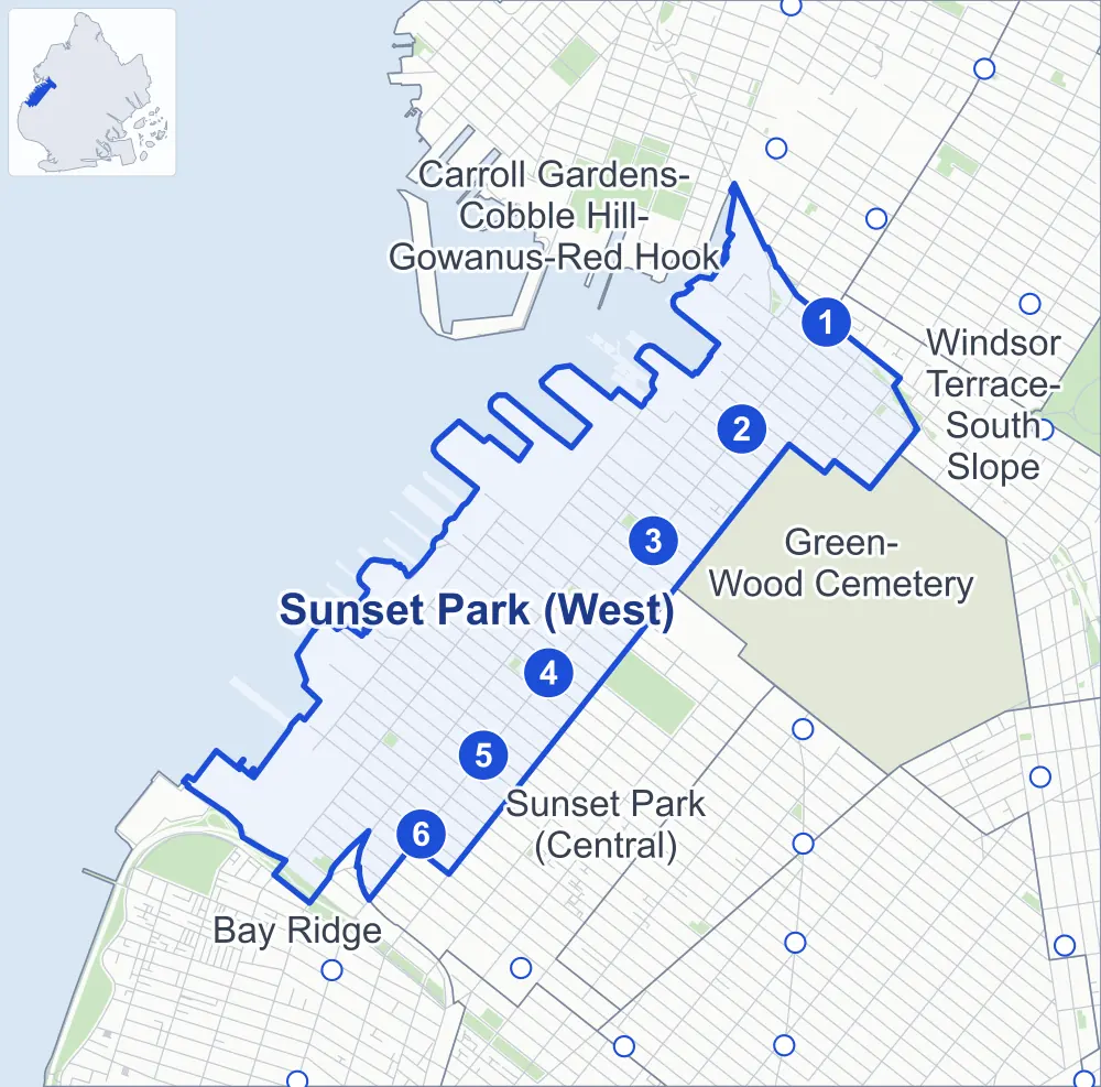
- Sunset Park (West)
- A neighboring area
- Park
- A station in the list
- Another station
Neighborhood areas and streets: NYC Department of City Planning. Parks: NYC Parks. Stations: MTA.
Neighboring areas
- Windsor Terrace-South Slope northeast
- Carroll Gardens-Cobble Hill-Gowanus-Red Hook northeast
- Green-Wood Cemetery east
- Sunset Park (Central) south
- Bay Ridge southwest
Subway stations
- Prospect Av lines R
- 25 St lines R
- 36 St lines D N R
- 45 St lines R
- 53 St lines R
- 59 St lines N R accessible
Getting around
Six subway stations and buses on ten routes stop in or at the edge of Sunset Park (West).
- 6 subway stations
- 1 of them listed by the MTA as fully accessible
- 8 local bus routes
- 2 express bus routes
Local bus routes
- B9
- B11
- B35
- B37
- B63
- B67
- B69
- B70
Express bus routes
- X27
- X37
Safety record
Between 2021 and 2025, its corners averaged more police-reported crashes than the average Brooklyn corner.
- 3,419 police-reported crashes at its corners
- 15.9 a corner, on average
- 10.5 the average Brooklyn corner
- 12 corners with a clean record
Signal or safety changes on City record, at 110 of its corners
- Leading pedestrian intervals
- 106
- Accessible pedestrian signals
- 14
- Barnes Dance all-way crossings
- 1
- Enhanced crossings
- 1
- Safety Improvement Projects
- 1
Camera tickets
In 2025 its corners had more school-zone speed camera tickets than red-light or bus-lane tickets.
- 2,836 red-light camera tickets at one corner
- 23,246 school-zone speed camera tickets at 18 corners
- 0 bus-lane camera tickets
- Most red-light tickets
- 4th Avenue & 18th Street, 2,836
- Most speed tickets
- Gowanus Expressway & 3rd Avenue at 41st Street, 7,116
People and homes
The 2020 Census counted 54,473 residents in Sunset Park (West), about 30,100 per square mile.
- 18,619 homes, 2020 Census
- 1,376 homes added since April 2010, net, by City Planning's count
Half of its 4,599 residential lots hold buildings from 1910 or earlier, and 93% of them date from before 1940, by the City's tax lot records.
Parks and landmarks
- Parkland
- 10.9 acres of NYC Parks property
- The largest pieces
- Shore Park and Parkway (3.6 acres), John Allen Payne Playground (1.4 acres) and D'Emic Playground (1.2 acres)
- Designated landmarks
- 68th Police Precinct Station House; 68th Police Precinct Station Stable; the Firehouse, Engine Company 28; and the Weir Greenhouse, among others
- Historic districts
- Sunset Park 50th Street and Sunset Park South, wholly or partly within Sunset Park (West)
Streets and trees
- Trees
- 4,088 in NYC Parks' records, most often London planetree, thornless honeylocust and pin oak
- Street with the most corners
- Gowanus Expressway, with 59 of the area's 215
- Height above sea level
- From 5 feet at 2nd Avenue & 30th Street to 154 feet at 7th Avenue & 22nd Street
- Honorary street names
- 4 at its corners, enacted by local law
Schools and libraries
The City lists 26 schools and one library in Sunset Park (West).
- Public schools
- 19
- Charter and private schools
- 7
- Library
- Sunset Park Library
Bike share
By the station list of October 3, 2026, 40 bike-share stations stand in Sunset Park (West).
- 40 bike-share stations
Public safety
How complaints are countedIn 2025 the NYPD recorded 428 major felonies at places in Sunset Park (West).
Recorded by the NYPD at places in Sunset Park (West)
- 538 major felonies in 2024 110 fewer in 2025
- 2,004 other felonies, misdemeanors and violations in 2025
In 2025, on the streets along the edge of Sunset Park (West), the NYPD recorded another 97 major felonies. Counting the streets along its edge, in 2025 the NYPD recorded 9.6 major felonies for every thousand residents the 2020 Census counted in Sunset Park (West).
- Police precincts
- 72nd (most of the area), 68th, 76th
From January to June 2026 the NYPD recorded 181 major felonies at places in Sunset Park (West), against 167 in the same months of 2025.
Sources: the NYPD's Complaint Data Historic, updated April 28, 2026, and Complaint Data Current (Year To Date), updated July 27, 2026, on NYC Open Data. Figures to June 30, 2026.
Street corners
- 1st Avenue & 40th Street
- 2nd Avenue & 28th Street
- 2nd Avenue & 29th Street
- 2nd Avenue & 30th Street
- 2nd Avenue & 32nd Street
- 2nd Avenue & 33rd Street
- 2nd Avenue & 34th Street
- 2nd Avenue & 35th Street
- 2nd Avenue & 36th Street
- 2nd Avenue & 37th Street
- 2nd Avenue & 39th Street
- 2nd Avenue & 40th Street
- 2nd Avenue & 41st Street
- 2nd Avenue & 42nd Street
- 2nd Avenue & 43rd Street
- 2nd Avenue & 44th Street
- 2nd Avenue & 45th Street
- 2nd Avenue & 46th Street
- 2nd Avenue & 47th Street
- 2nd Avenue & 48th Street
- 2nd Avenue & 49th Street
- 2nd Avenue & 50th Street
- 2nd Avenue & 51st Street
- 2nd Avenue & 55th Street
- 2nd Avenue & 56th Street
- 2nd Avenue & 57th Street
- 2nd Avenue & 61st Street
- 2nd Avenue & 63rd Street
- 2nd Avenue & Gowanus Expressway
- 3rd Avenue & 17th Street
- 3rd Avenue & 18th Street
- 3rd Avenue & 64th Street
- 3rd Avenue & 65th Street
- 3rd Avenue & Gowanus Expressway (north)
- 3rd Avenue & Gowanus Expressway (south)
- 3rd Avenue & Hamilton Avenue
- 3rd Avenue & I 278
- 3rd Avenue & Prospect Avenue
- 3rd Avenue & Prospect Expressway
- 4th Avenue & 17th Street
- 4th Avenue & 18th Street
- 4th Avenue & 19th Street
- 4th Avenue & 20th Street
- 4th Avenue & 21st Street
- 4th Avenue & 22nd Street
- 4th Avenue & 23rd Street
- 4th Avenue & 24th Street
- 4th Avenue & 25th Street
- 4th Avenue & 26th Street
- 4th Avenue & 27th Street
- 4th Avenue & 28th Street
- 4th Avenue & 29th Street
- 4th Avenue & 30th Street
- 4th Avenue & 31st Street
- 4th Avenue & 32nd Street
- 4th Avenue & 33rd Street
- 4th Avenue & 34th Street
- 4th Avenue & 35th Street
- 4th Avenue & 36th Street
- 4th Avenue & 37th Street
- 4th Avenue & 38th Street
- 4th Avenue & 39th Street
- 4th Avenue & 40th Street
- 4th Avenue & 41st Street
- 4th Avenue & 42nd Street
- 4th Avenue & 43rd Street
- 4th Avenue & 44th Street
- 4th Avenue & 45th Street
- 4th Avenue & 46th Street
- 4th Avenue & 47th Street
- 4th Avenue & 48th Street
- 4th Avenue & 49th Street
- 4th Avenue & 50th Street
- 4th Avenue & 51st Street
- 4th Avenue & 52nd Street
- 4th Avenue & 53rd Street
- 4th Avenue & 54th Street
- 4th Avenue & 55th Street
- 4th Avenue & 56th Street
- 4th Avenue & 57th Street
- 4th Avenue & 58th Street
- 4th Avenue & 59th Street
- 5th Avenue & 17th Street
- 5th Avenue & 18th Street
- 5th Avenue & 19th Street
- 5th Avenue & 20th Street
- 5th Avenue & 21st Street
- 5th Avenue & 22nd Street
- 5th Avenue & 23rd Street
- 5th Avenue & 24th Street
- 5th Avenue & 25th Street
- 5th Avenue & 26th Street
- 5th Avenue & 27th Street
- 5th Avenue & 28th Street
- 5th Avenue & 29th Street
- 5th Avenue & 30th Street
- 5th Avenue & 31st Street
- 5th Avenue & 32nd Street
- 5th Avenue & 33rd Street
- 5th Avenue & 34th Street
- 5th Avenue & 38th Street
- 5th Avenue & 40th Street
- 5th Avenue & 43rd Street
- 5th Avenue & 45th Street
- 5th Avenue & 46th Street
- 5th Avenue & 47th Street
- 5th Avenue & 49th Street
- 5th Avenue & 50th Street
- 5th Avenue & 56th Street
- 6th Avenue & 17th Street
- 6th Avenue & 18th Street
- 6th Avenue & 19th Street
- 6th Avenue & 20th Street
- 6th Avenue & 21st Street
- 6th Avenue & 22nd Street
- 6th Avenue & 23rd Street
- 7th Avenue & 18th Street
- 7th Avenue & 21st Street
- 7th Avenue & 22nd Street
- 7th Avenue & 23rd Street
- 17th Street & Prospect Expressway
- 18th Street & Hamilton Avenue
- 30th Street & Woodrow Court
- 38th Street & Gowanus Expressway
- 39th Street & 1st Avenue
- 41st Street & 1st Avenue
- 42nd Street & 1st Avenue
- 43rd Street & 1st Avenue
- 44th Street & 1st Avenue
- 47th Street & 1st Avenue
- 48th Street & 1st Avenue
- 49th Street & 1st Avenue
- 50th Street & 1st Avenue
- 51st Street & 1st Avenue
- 52nd Street & 1st Avenue
- 52nd Street & 2nd Avenue
- 53rd Street & 1st Avenue
- 53rd Street & 2nd Avenue
- 54th Street & 1st Avenue
- 54th Street & 2nd Avenue
- 55th Street & 1st Avenue
- 56th Street & 1st Avenue
- 57th Street & 1st Avenue
- 58th Street & 1st Avenue
- 58th Street & 2nd Avenue
- 59th Street & 2nd Avenue
- 59th Street & Gowanus Expressway
- 59th Street & Gowanus Expressway (Exit 22)
- 60th Street & 2nd Avenue
- 62nd Street & 2nd Avenue
- 64th Street & 2nd Avenue
- 65th Street & 2nd Avenue
- Belt Parkway & 3rd Avenue
- Belt Parkway & 64th Street
- Belt Parkway & 65th Street
- Belt Parkway & Gowanus Expressway at 3rd Avenue
- Gowanus Expressway & 3rd Avenue
- Gowanus Expressway & 3rd Avenue at 19th Street
- Gowanus Expressway & 3rd Avenue at 20th Street
- Gowanus Expressway & 3rd Avenue at 21st Street
- Gowanus Expressway & 3rd Avenue at 22nd Street
- Gowanus Expressway & 3rd Avenue at 23rd Street
- Gowanus Expressway & 3rd Avenue at 24th Street
- Gowanus Expressway & 3rd Avenue at 25th Street
- Gowanus Expressway & 3rd Avenue at 26th Street
- Gowanus Expressway & 3rd Avenue at 27th Street
- Gowanus Expressway & 3rd Avenue at 28th Street
- Gowanus Expressway & 3rd Avenue at 29th Street
- Gowanus Expressway & 3rd Avenue at 30th Street
- Gowanus Expressway & 3rd Avenue at 31st Street
- Gowanus Expressway & 3rd Avenue at 32nd Street
- Gowanus Expressway & 3rd Avenue at 33rd Street
- Gowanus Expressway & 3rd Avenue at 34th Street
- Gowanus Expressway & 3rd Avenue at 35th Street
- Gowanus Expressway & 3rd Avenue at 36th Street
- Gowanus Expressway & 3rd Avenue at 37th Street
- Gowanus Expressway & 3rd Avenue at 38th Street
- Gowanus Expressway & 3rd Avenue at 39th Street
- Gowanus Expressway & 3rd Avenue at 40th Street
- Gowanus Expressway & 3rd Avenue at 41st Street
- Gowanus Expressway & 3rd Avenue at 42nd Street
- Gowanus Expressway & 3rd Avenue at 43rd Street
- Gowanus Expressway & 3rd Avenue at 44th Street
- Gowanus Expressway & 3rd Avenue at 45th Street
- Gowanus Expressway & 3rd Avenue at 46th Street
- Gowanus Expressway & 3rd Avenue at 47th Street
- Gowanus Expressway & 3rd Avenue at 48th Street
- Gowanus Expressway & 3rd Avenue at 49th Street
- Gowanus Expressway & 3rd Avenue at 50th Street
- Gowanus Expressway & 3rd Avenue at 51st Street
- Gowanus Expressway & 3rd Avenue at 52nd Street
- Gowanus Expressway & 3rd Avenue at 53rd Street
- Gowanus Expressway & 3rd Avenue at 54th Street
- Gowanus Expressway & 3rd Avenue at 55th Street
- Gowanus Expressway & 3rd Avenue at 56th Street
- Gowanus Expressway & 3rd Avenue at 57th Street
- Gowanus Expressway & 3rd Avenue at 58th Street
- Gowanus Expressway & 3rd Avenue at 59th Street
- Gowanus Expressway & 3rd Avenue at 64th Street
- Gowanus Expressway & 17th Street
- Gowanus Expressway & 18th Street
- Gowanus Expressway & Hamilton Avenue at 14th Street
- Gowanus Expressway & Hamilton Avenue at 15th Street
- Gowanus Expressway & Hamilton Avenue Bridge
- Gowanus Expressway & Hamilton Avenue Bridge at Hamilton Avenue
- Hamilton Avenue & 17th Street
- Hamilton Avenue & I 278
- Prospect Expressway & 4th Avenue
- Prospect Expressway & 5th Avenue
- Prospect Expressway & 6th Avenue
- Prospect Expressway & 7th Avenue
- Prospect Expressway & I 278
- Ridge Boulevard & Shore Road Drive
- Ridge Boulevard & Wakeman Place
- Shore Road Drive & Belt Parkway
How the figures above are measured: Methodology.