Bay Ridge
Neighborhood · Brooklyn
Bay Ridge lines the Narrows from Sunset Park south to the Fort Hamilton Army post and the Verrazzano-Narrows Bridge, which opened in 1964.
- 2.21 square miles
- 86,779 residents, 2020 Census
- 384 street corners
- 4 subway stations
- 16 bus routes
Dutch settlers called the area Yellow Hook for the yellow clay along its shore until residents chose the name Bay Ridge in 1853; country houses rose along Shore Road in the mid-1800s, and building took off after the Fourth Avenue subway reached 86th Street in 1916. Doctors' Row, a block of 54 rowhouses on Bay Ridge Parkway, became the neighborhood's first city historic district in 2019, and Third Avenue hosts the yearly Norwegian Constitution Day Parade.
Sources: Bay Ridge, Brooklyn (Wikipedia); Owl's Head Park History (NYC Parks); LPC Designates the First Historic District in Bay Ridge, Brooklyn (NYC Landmarks Preservation Commission).
Bay Ridge borders five areas, and 4th Avenue holds more of its corners than any other street, 42 of 384.
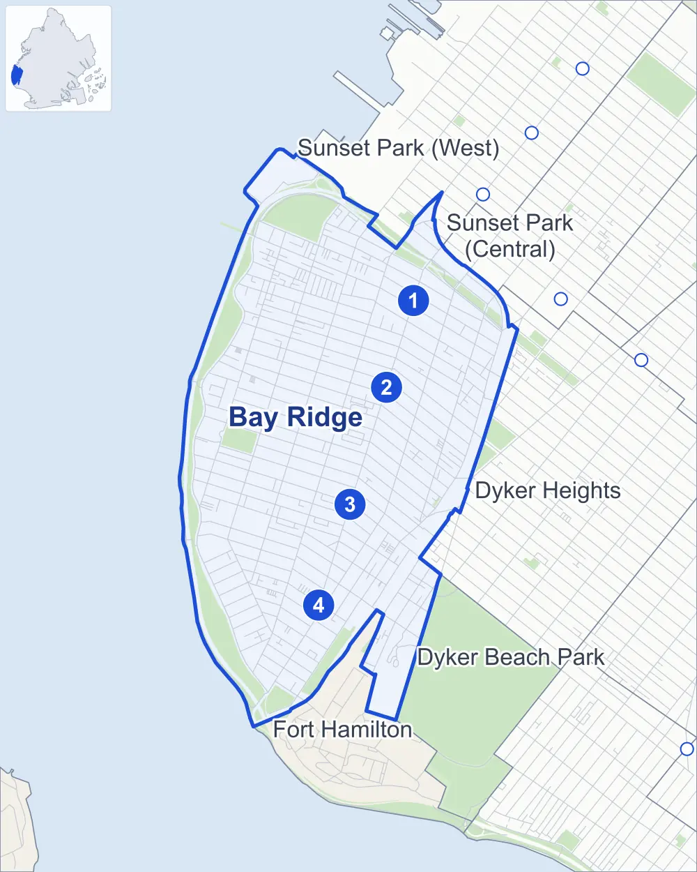
- Bay Ridge
- A neighboring area
- Park
- A station in the list
- Another station
Neighborhood areas and streets: NYC Department of City Planning. Parks: NYC Parks. Stations: MTA.
Neighboring areas
- Sunset Park (West) north
- Sunset Park (Central) northeast
- Dyker Heights east
- Dyker Beach Park southeast
- Fort Hamilton south
Subway stations
- Bay Ridge Av lines R
- 77 St lines R
- 86 St lines R accessible
- Bay Ridge-95 St lines R accessible
Getting around
Four subway stations and buses on 16 routes stop in or at the edge of Bay Ridge.
- 4 subway stations
- 2 of them listed by the MTA as fully accessible
- 12 local bus routes
- 4 express bus routes
Local bus routes
- B1
- B4
- B8
- B9
- B16
- B37
- B63
- B64
- B70
- S53
- S79-SBS
- S93
Express bus routes
- X27
- X28
- X37
- X38
Safety record
Between 2021 and 2025, its corners averaged fewer police-reported crashes than the average Brooklyn corner.
- 2,072 police-reported crashes at its corners
- 5.4 a corner, on average
- 10.5 the average Brooklyn corner
- 48 corners with a clean record
Signal or safety changes on City record, at 118 of its corners
- Leading pedestrian intervals
- 99
- Accessible pedestrian signals
- 44
- Turn calming
- 9
- Barnes Dance all-way crossings
- 5
- Safety Improvement Projects
- 3
- Enhanced crossings
- 1
Camera tickets
In 2025 its corners had more school-zone speed camera tickets than red-light or bus-lane tickets.
- 1,670 red-light camera tickets at one corner
- 23,696 school-zone speed camera tickets at 29 corners
- 0 bus-lane camera tickets
- Most red-light tickets
- 7th Avenue & 86th Street, 1,670
- Most speed tickets
- Shore Road & 83rd Street, 4,495
People and homes
The 2020 Census counted 86,779 residents in Bay Ridge, about 39,300 per square mile.
- 38,534 homes, 2020 Census
- 298 homes added since April 2010, net, by City Planning's count
Half of its 9,670 residential lots hold buildings from 1925 or earlier, and 90% of them date from before 1940, by the City's tax lot records.
Parks and landmarks
- Parkland
- 136.4 acres of NYC Parks property
- The largest pieces
- Shore Park and Parkway (83 acres), Owl's Head Park (24.2 acres) and John J Carty Park (8.6 acres)
- Historic district
- Bay Ridge Parkway-Doctors' Row Historic District, wholly or partly within Bay Ridge
Streets and trees
- Trees
- 9,534 in NYC Parks' records, most often London planetree, pin oak and thornless honeylocust
- Street with the most corners
- 4th Avenue, with 42 of the area's 384
- Height above sea level
- From 11 feet at Shore Road & 68th Street to 172 feet at Verrazzano-Narrows Bridge & Belt Parkway
- Honorary street names
- 52 at its corners, enacted by local law
Schools and libraries
The City lists 23 schools and two libraries in Bay Ridge.
- Public schools
- 11
- Charter and private schools
- 12
- Libraries
- Bay Ridge Library and Fort Hamilton Library
Bike share and public art
By the station list of October 3, 2026, 50 bike-share stations stand in Bay Ridge. The City's public art inventory lists six works in the area, among them Fort Hamilton War Memorial (1920), Dover Patrol Monument (1931) and Leiv Eiriksson (1939).
- 50 bike-share stations
- 6 works of public art
Public safety
How complaints are countedIn 2025 the NYPD recorded 520 major felonies at places in Bay Ridge.
Recorded by the NYPD at places in Bay Ridge
- 515 major felonies in 2024
- 2,565 other felonies, misdemeanors and violations in 2025
In 2025, on the streets along the edge of Bay Ridge, the NYPD recorded another 16 major felonies. Counting the streets along its edge, in 2025 the NYPD recorded 6.2 major felonies for every thousand residents the 2020 Census counted in Bay Ridge.
- Police precincts
- 68th (most of the area), 72nd
From January to June 2026 the NYPD recorded 264 major felonies at places in Bay Ridge, against 257 in the same months of 2025.
Sources: the NYPD's Complaint Data Historic, updated April 28, 2026, and Complaint Data Current (Year To Date), updated July 27, 2026, on NYC Open Data. Figures to June 30, 2026.
Street corners
- 3rd Avenue & 67th Street
- 3rd Avenue & 68th Street
- 3rd Avenue & 71st Street
- 3rd Avenue & 72nd Street
- 3rd Avenue & 73rd Street
- 3rd Avenue & 74th Street
- 3rd Avenue & 76th Street
- 3rd Avenue & 77th Street
- 3rd Avenue & 78th Street
- 3rd Avenue & 79th Street
- 3rd Avenue & 80th Street
- 3rd Avenue & 81st Street
- 3rd Avenue & 82nd Street
- 3rd Avenue & 83rd Street
- 3rd Avenue & 84th Street
- 3rd Avenue & 85th Street
- 3rd Avenue & 86th Street
- 3rd Avenue & 87th Street
- 3rd Avenue & 88th Street
- 3rd Avenue & 89th Street
- 3rd Avenue & 90th Street
- 3rd Avenue & 91st Street
- 3rd Avenue & 92nd Street
- 3rd Avenue & 93rd Street
- 3rd Avenue & 94th Street
- 3rd Avenue & 95th Street
- 3rd Avenue & 96th Street
- 3rd Avenue & 97th Street
- 3rd Avenue & 99th Street
- 3rd Avenue & 100th Street
- 3rd Avenue & 101st Street
- 3rd Avenue & Bay Ridge Avenue
- 3rd Avenue & Bay Ridge Parkway
- 3rd Avenue & Gowanus Expressway
- 3rd Avenue & Marine Avenue
- 3rd Avenue & Ovington Avenue
- 3rd Avenue & Senator Street
- 3rd Avenue & Shore Road
- 3rd Avenue & Wakeman Place
- 4th Avenue & 65th Street
- 4th Avenue & 66th Street
- 4th Avenue & 67th Street
- 4th Avenue & 68th Street
- 4th Avenue & 72nd Street
- 4th Avenue & 73rd Street
- 4th Avenue & 74th Street
- 4th Avenue & 76th Street
- 4th Avenue & 77th Street
- 4th Avenue & 78th Street
- 4th Avenue & 79th Street
- 4th Avenue & 80th Street
- 4th Avenue & 81st Street
- 4th Avenue & 82nd Street
- 4th Avenue & 83rd Street
- 4th Avenue & 84th Street
- 4th Avenue & 85th Street
- 4th Avenue & 86th Street
- 4th Avenue & 87th Street
- 4th Avenue & 88th Street
- 4th Avenue & 89th Street
- 4th Avenue & 89th Street at Forest Place
- 4th Avenue & 90th Street
- 4th Avenue & 91st Street
- 4th Avenue & 92nd Street
- 4th Avenue & 93rd Street
- 4th Avenue & 94th Street
- 4th Avenue & 96th Street
- 4th Avenue & 97th Street
- 4th Avenue & 99th Street
- 4th Avenue & 100th Street
- 4th Avenue & 101st Street
- 4th Avenue & Bay Ridge Avenue
- 4th Avenue & Bay Ridge Parkway
- 4th Avenue & Gowanus Expressway
- 4th Avenue & Marine Avenue
- 4th Avenue & Ovington Avenue
- 4th Avenue & Senator Street
- 4th Avenue & Shore Road
- 4th Avenue & Shore Road Drive
- 5th Avenue & 4th Avenue
- 5th Avenue & 65th Street
- 5th Avenue & 66th Street
- 5th Avenue & 67th Street
- 5th Avenue & 68th Street
- 5th Avenue & 72nd Street
- 5th Avenue & 73rd Street
- 5th Avenue & 74th Street
- 5th Avenue & 76th Street
- 5th Avenue & 77th Street
- 5th Avenue & 78th Street
- 5th Avenue & 79th Street
- 5th Avenue & 80th Street
- 5th Avenue & 81st Street
- 5th Avenue & 82nd Street
- 5th Avenue & 83rd Street
- 5th Avenue & 84th Street
- 5th Avenue & 85th Street
- 5th Avenue & 86th Street
- 5th Avenue & 87th Street
- 5th Avenue & 88th Street
- 5th Avenue & 89th Street
- 5th Avenue & 90th Street
- 5th Avenue & 91st Street
- 5th Avenue & 92nd Street
- 5th Avenue & 94th Street
- 5th Avenue & Bay Ridge Avenue
- 5th Avenue & Bay Ridge Parkway
- 5th Avenue & Ovington Avenue
- 5th Avenue & Senator Street
- 6th Avenue & 65th Street at Gowanus Expressway
- 6th Avenue & 66th Street
- 6th Avenue & 67th Street
- 6th Avenue & 68th Street
- 6th Avenue & 71st Street
- 6th Avenue & 72nd Street
- 6th Avenue & 73rd Street
- 6th Avenue & 74th Street
- 6th Avenue & 76th Street
- 6th Avenue & 77th Street
- 6th Avenue & 78th Street
- 6th Avenue & 79th Street
- 6th Avenue & 80th Street
- 6th Avenue & 81st Street
- 6th Avenue & 82nd Street
- 6th Avenue & 83rd Street
- 6th Avenue & Bay Ridge Avenue
- 6th Avenue & Bay Ridge Parkway
- 6th Avenue & Ovington Avenue
- 6th Avenue & Senator Street
- 7th Avenue & 8th Avenue
- 7th Avenue & 67th Street
- 7th Avenue & 67th Street at Erik Place
- 7th Avenue & 68th Street (north-west)
- 7th Avenue & 68th Street (south-east)
- 7th Avenue & 71st Street (north-west)
- 7th Avenue & 71st Street (south-east)
- 7th Avenue & 72nd Street at 72nd Street Pedestrian Overpass
- 7th Avenue & 73rd Street
- 7th Avenue & 74th Street
- 7th Avenue & 76th Street
- 7th Avenue & 77th Street
- 7th Avenue & 78th Street
- 7th Avenue & 79th Street at Gowanus Expressway
- 7th Avenue & 80th Street
- 7th Avenue & 81st Street
- 7th Avenue & 86th Street
- 7th Avenue & 88th Street
- 7th Avenue & 90th Street
- 7th Avenue & 92nd Street
- 7th Avenue & Bay Ridge Avenue
- 7th Avenue & Bay Ridge Parkway
- 7th Avenue & De Russy Drive
- 7th Avenue & Fort Hamilton Parkway at 80th Street
- 7th Avenue & Fort Hamilton Parkway at 82nd Street
- 7th Avenue & Fort Hamilton Parkway at Gowanus Expressway
- 7th Avenue & Ovington Avenue
- 7th Avenue & Parrott Place
- 7th Avenue & Poly Prep Drive
- 66th Street & Shore Road Drive
- 67th Street & Bergen Place
- 67th Street & Colonial Road
- 67th Street & Ridge Boulevard
- 67th Street & Sedgwick Place
- 67th Street & Shore Road Drive
- 68th Street & Bay Cliff Terrace
- 68th Street & Bliss Terrace
- 68th Street & Colonial Road
- 68th Street & Madeline Court
- 68th Street & Narrows Avenue
- 68th Street & Owls Head Court
- 68th Street & Ridge Boulevard
- 68th Street & Vista Place
- 70th Street & Colonial Road
- 70th Street & Louise Terrace
- 70th Street & Narrows Avenue
- 70th Street & Perry Terrace
- 70th Street & Ridge Boulevard
- 70th Street & Ridge Crest Terrace
- 71st Street & Colonial Road
- 71st Street & Narrows Avenue
- 71st Street & Perry Terrace
- 71st Street & Ridge Boulevard
- 71st Street & Ridge Crest Terrace
- 71st Street & Stewart Avenue
- 72nd Street & 72nd Court
- 72nd Street & Bennett Court
- 72nd Street & Colonial Road
- 72nd Street & Narrows Avenue
- 72nd Street & Ridge Boulevard
- 72nd Street & Ridge Court
- 72nd Street & Stewart Avenue
- 73rd Street & Colonial Road
- 73rd Street & Narrows Avenue
- 73rd Street & Ridge Boulevard
- 73rd Street & Stewart Avenue
- 74th Street & Colonial Road
- 74th Street & Narrows Avenue
- 74th Street & Ridge Boulevard
- 74th Street & Stewart Avenue
- 76th Street & Colonial Road
- 76th Street & Narrows Avenue
- 76th Street & Ridge Boulevard
- 77th Street & Colonial Road
- 77th Street & Narrows Avenue
- 77th Street & Ridge Boulevard
- 78th Street & Colonial Road
- 78th Street & Narrows Avenue
- 78th Street & Ridge Boulevard
- 79th Street & Colonial Road
- 79th Street & Narrows Avenue
- 79th Street & Ridge Boulevard
- 80th Street & Colonial Road
- 80th Street & Harbor View Terrace
- 80th Street & Narrows Avenue
- 80th Street & Ridge Boulevard
- 81st Street & Colonial Road
- 81st Street & Narrows Avenue
- 81st Street & Ridge Boulevard
- 82nd Street & Colonial Road
- 82nd Street & Harbor View Terrace
- 82nd Street & Narrows Avenue
- 82nd Street & Ridge Boulevard
- 82nd Street & Shore Road
- 83rd Street & Colonial Road
- 83rd Street & Dyker Place
- 83rd Street & Narrows Avenue
- 83rd Street & Ridge Boulevard
- 84th Street & Colonial Road
- 84th Street & Ridge Boulevard
- 85th Street & Colonial Road
- 85th Street & Narrows Avenue
- 85th Street & Ridge Boulevard
- 86th Street & Battery Avenue
- 86th Street & Colonial Road
- 86th Street & Dahlgren Place
- 86th Street & Fort Hamilton Parkway
- 86th Street & Gelston Avenue
- 86th Street & Gowanus Expressway
- 86th Street & Gowanus Expressway at Gatling Place
- 86th Street & Narrows Avenue
- 86th Street & Ridge Boulevard
- 86th Street & Shore Road
- 88th Street & Battery Avenue
- 88th Street & Dahlgren Place
- 88th Street & Gatling Place
- 88th Street & Gelston Avenue
- 88th Street & Parrott Place
- 89th Street & Shore Court
- 90th Street & Battery Avenue
- 90th Street & Dahlgren Place
- 90th Street & Forest Place
- 90th Street & Gatling Place
- 90th Street & Gelston Avenue
- 90th Street & Parrott Place
- 92nd Street & Battery Avenue
- 92nd Street & Dahlgren Place
- 92nd Street & Gatling Place
- 92nd Street & Gelston Avenue
- 92nd Street & Poly Prep Drive
- 92nd Street & Verrazzano-Narrows Bridge
- 94th Street & Hamilton Walk
- 94th Street & Lafayette Walk
- 94th Street & Wogan Terrace
- 95th Street & Marine Avenue
- 97th Street & Barwell Terrace
- 98th Street & Harbor Court
- 99th Street & Harbor Court
- 101st Street & Jackson Court
- Battery Avenue & Fort Hill Place
- Bay Ridge Avenue & Bay Ridge Place
- Bay Ridge Avenue & Bliss Terrace
- Bay Ridge Avenue & Colonial Road
- Bay Ridge Avenue & Narrows Avenue
- Bay Ridge Avenue & Owls Head Court
- Bay Ridge Avenue & Ridge Boulevard
- Bay Ridge Avenue & Vista Place
- Bay Ridge Parkway & Colonial Road
- Bay Ridge Parkway & Narrows Avenue
- Bay Ridge Parkway & Ridge Boulevard
- Belt Parkway & Bay Ridge Avenue
- Belt Parkway & Ridge Boulevard
- Belt Parkway & Shore Parkway Greenway-80th Street Pedestrian Oval
- Belt Parkway & Verrazzano-Narrows Bridge
- Colonial Road & 87th Street
- Colonial Road & 88th Street
- Colonial Road & 89th Street
- Colonial Road & 91st Street
- Colonial Road & 92nd Street
- Colonial Road & Mackay Place
- Colonial Road & Senator Street
- Dahlgren Place & Gowanus Expressway
- Erik Place & Gowanus Expressway
- Fort Hamilton Parkway & 81st Street
- Fort Hamilton Parkway & 83rd Street
- Fort Hamilton Parkway & 84th Street
- Fort Hamilton Parkway & 85th Street
- Fort Hamilton Parkway & 88th Street
- Fort Hamilton Parkway & 90th Street
- Fort Hamilton Parkway & 92nd Street
- Fort Hamilton Parkway & 94th Street
- Fort Hamilton Parkway & 95th Street
- Fort Hamilton Parkway & 97th Street
- Fort Hamilton Parkway & 99th Street
- Fort Hamilton Parkway & 100th Street
- Fort Hamilton Parkway & Gowanus Expressway (Exit 18)
- Fort Hamilton Parkway & Gowanus Expressway (Exit 19)
- Fort Hamilton Parkway & John Warren Avenue
- Fort Hamilton Parkway & Marine Avenue
- Gatling Place & Gowanus Expressway
- Gowanus Expressway & 3rd Avenue at 4th Avenue
- Gowanus Expressway & 6th Avenue
- Gowanus Expressway & 7th Avenue
- Gowanus Expressway & 86th Street
- Gowanus Expressway & Bay Ridge Parkway
- Gowanus Expressway & Gowanus Exwpy Overpass 79th Street
- Gowanus Expressway & Ovington Avenue
- Gowanus Expressway & Verrazzano Bridge Upper
- Harbor View Terrace & Colonial Court
- Harbor View Terrace & Harbor Lane
- Mackay Place & Louise Terrace
- Marine Avenue & 93rd Street
- Marine Avenue & 94th Street
- Marine Avenue & 96th Street
- Marine Avenue & 97th Street
- Marine Avenue & 98th Street
- Marine Avenue & Oliver Street
- Narrows Avenue & 87th Street
- Narrows Avenue & 88th Street
- Narrows Avenue & 89th Street
- Narrows Avenue & Colonial Gardens
- Narrows Avenue & Mackay Place
- Ovington Avenue & Bay Ridge Place
- Ovington Avenue & Ridge Boulevard
- Ovington Avenue & Stewart Avenue
- Poly Place & Battery Avenue
- Ridge Boulevard & 87th Street
- Ridge Boulevard & 88th Street
- Ridge Boulevard & 89th Street
- Ridge Boulevard & 90th Street
- Ridge Boulevard & 91st Street
- Ridge Boulevard & 92nd Street
- Ridge Boulevard & 93rd Street
- Ridge Boulevard & 94th Street
- Ridge Boulevard & 95th Street
- Ridge Boulevard & Belt Parkway (Ridge Boulevard)
- Ridge Boulevard & Belt Parkway (Southbound)
- Ridge Boulevard & Senator Street
- Shore Road & 68th Street
- Shore Road & 71st Street
- Shore Road & 72nd Street
- Shore Road & 74th Street
- Shore Road & 77th Street
- Shore Road & 78th Street
- Shore Road & 79th Street
- Shore Road & 80th Street
- Shore Road & 83rd Street
- Shore Road & 87th Street
- Shore Road & 88th Street
- Shore Road & 91st Street
- Shore Road & 92nd Street
- Shore Road & 92nd Street Pedestrian Overpass
- Shore Road & 93rd Street
- Shore Road & 94th Street
- Shore Road & 95th Street
- Shore Road & 96th Street
- Shore Road & 97th Street
- Shore Road & 99th Street
- Shore Road & Bay Ridge Avenue
- Shore Road & Bay Ridge Parkway
- Shore Road & Belt Parkway
- Shore Road & Belt Parkway (Exit 1)
- Shore Road & Colonial Road
- Shore Road & Fort Hamilton High School Driveway
- Shore Road & Mackay Place
- Shore Road & Oliver Street
- Shore Road & Ridge Boulevard
- Shore Road & Shore Parkway Greenway-80th Street Pedestrian Oval
- Shore Road & Shore Road Drive
- Shore Road & Shore Road Lane
- Shore Road Drive & Belt Parkway
- Verrazzano-Narrows Bridge & Belt Parkway
- Verrazzano-Narrows Bridge & Belt Parkway (Exit 2)
- Wakeman Place & Bergen Place
- Wakeman Place & Sedgwick Place
How the figures above are measured: Methodology.