Fort Hamilton
Brooklyn
Fort Hamilton is the U.S. Army post in the southwestern corner of Brooklyn, surrounded by Bay Ridge and Dyker Heights near the Verrazzano-Narrows Bridge.
- 0.30 square miles
- 45 street corners
- 2 bus routes
Named for Alexander Hamilton, the first secretary of the Treasury, its fort was built from 1825 to 1831 in the round of coastal defenses that followed the War of 1812. The Army describes it as New York City's only active-duty installation, and it hosts units such as the New York Military Entrance Processing Station; the Harbor Defense Museum, set in the small outwork that once guarded the fort's gate, explores the history of the fort and of New York's seacoast defenses.
Sources: Fort Hamilton (Wikipedia); Garrison (U.S. Army Garrison Fort Hamilton); Bay Ridge, Brooklyn (Wikipedia).
Fort Hamilton borders three areas, and John Warren Avenue and Marshall Drive hold more of its corners than any other street, eight each of 45.
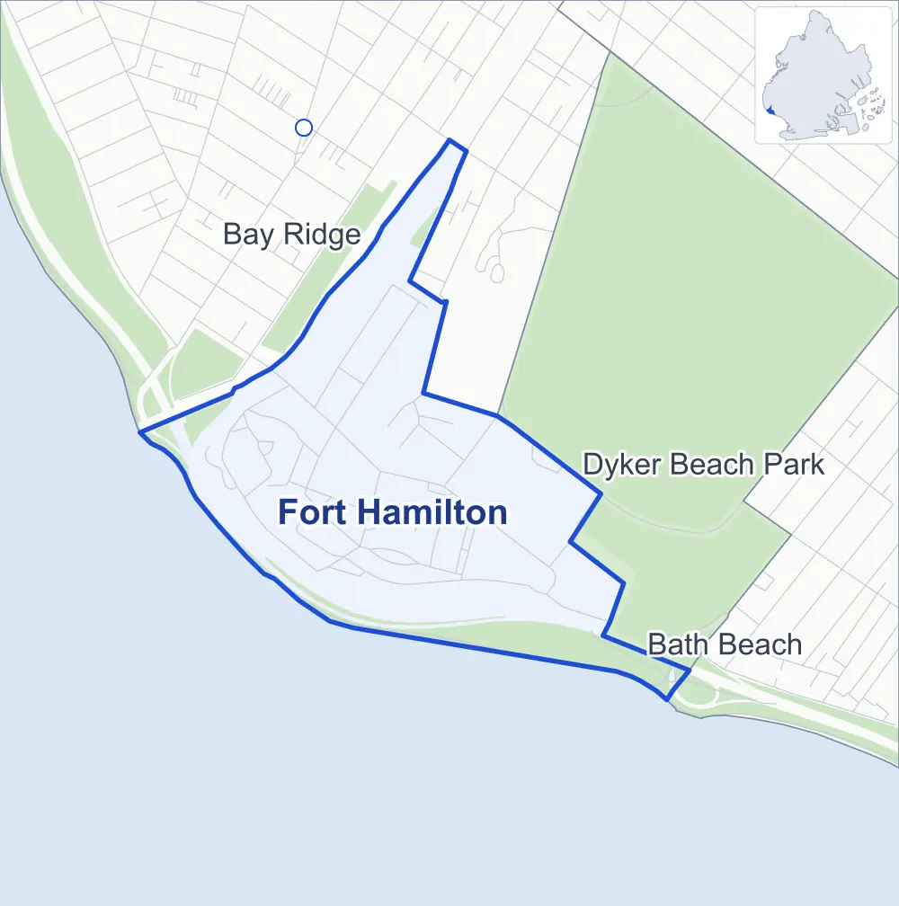
- Fort Hamilton
- A neighboring area
- Park
- Another station
Neighborhood areas and streets: NYC Department of City Planning. Parks: NYC Parks. Stations: MTA.
Neighboring areas
- Bay Ridge north
- Dyker Beach Park east
- Bath Beach southeast
Getting around
Buses on two routes stop in or at the edge of Fort Hamilton.
- 2 local bus routes
Local bus routes
- B8
- B70
Safety record
Between 2021 and 2025, its corners averaged fewer police-reported crashes than the average Brooklyn corner.
- 34 police-reported crashes at its corners
- 0.8 a corner, on average
- 10.5 the average Brooklyn corner
- 40 corners with a clean record
Camera tickets
In 2025 its corners had more school-zone speed camera tickets than red-light or bus-lane tickets.
- 0 red-light camera tickets
- 1,363 school-zone speed camera tickets at one corner
- 0 bus-lane camera tickets
- Most speed tickets
- 7th Avenue & Poly Place at Wainwright Drive, 1,363
Landmarks
- Designated landmark
- The Fort Hamilton Casemate Fort
Streets and trees
- Trees
- 524 in NYC Parks' records, most often serviceberry, eastern redcedar and American holly
- Street with the most corners
- John Warren Avenue, with eight of the area's 45
- Height above sea level
- From 13 feet at John Warren Avenue & Pershing Loop West to 54 feet at Dahlgren Place & Gowanus Expressway
- Honorary street name
- 1 at its corners, enacted by local law
Street corners
- 7th Avenue & Poly Place at Wainwright Drive
- Belt Parkway & Gowanus Expressway
- Dahlgren Place & Fort Hill Place
- Dahlgren Place & Gowanus Expressway (north)
- Dahlgren Place & Gowanus Expressway (south)
- Gowanus Expressway & 92nd Street
- Gowanus Expressway & John Warren Avenue
- Gowanus Expressway & Verrazzano-Narrows Bridge
- Grimes Road & Liberty Way
- Grimes Road & Marshall Drive
- Grimes Road & Roosevelt Lane
- Grimes Road North & Grimes Road West
- Grimes Road North & Wainwright Drive
- Grimes Road West & Hamilton Circle
- Grimes Road West & Hamilton Manor
- John Warren Avenue & Grimes Road
- John Warren Avenue & McArthur Road
- John Warren Avenue & Pershing Loop West
- John Warren Avenue & Schum Avenue
- John Warren Avenue & Wainwright Drive
- Liberty Way & Doubleday Circle
- Liberty Way & Doubleday Lane
- Liberty Way & Marshall Drive
- Liberty Way & McArthur Road
- Marshall Drive & Doubleday Lane
- Marshall Drive & Marshall Drive South at Marshall Drive North (east)
- Marshall Drive & Marshall Drive South at Marshall Drive North (west)
- Marshall Drive & McArthur Road
- Marshall Drive & Washington Road
- Pershing Loop North & Pershing Loop East
- Schum Avenue & 1 Division Avenue
- Schum Avenue & Walke Avenue
- Sterling Drive & Grimes Road
- Sterling Drive & John Warren Avenue
- Sterling Drive & McArthur Road
- Sterling Drive & Pence Street
- Sterling Drive & Pershing Loop South
- Sterling Drive & Stonewall Jackson Drive
- Stonewall Jackson Drive & Grimes Road
- Stonewall Jackson Drive & Washington Road
- White Avenue & 1 Division Avenue
- White Avenue & John Warren Avenue
- White Avenue & Marshall Drive
- White Avenue & Pence Street
- White Avenue & Walke Avenue
How the figures above are measured: Methodology.