Greenpoint
Neighborhood · Brooklyn
Greenpoint is Brooklyn's northernmost neighborhood, with the East River on its west and Newtown Creek, across from Long Island City in Queens, on its north.
- 1.27 square miles
- 38,980 residents, 2020 Census
- 212 street corners
- 2 subway stations
- 7 bus routes
The name comes from a small riverside bluff at the end of today's Freeman Street. In the 19th century the area filled with shipyards, glassworks, potteries and foundries, among them the ironworks that launched the Civil War ironclad USS Monitor in 1862. Today it is known for the Italianate and Queen Anne rowhouses of its landmark district, whose first buildings went up in the early 1850s, a large Polish community and parks such as McGolrick Park and WNYC Transmitter Park.
Sources: Greenpoint, Brooklyn (Wikipedia); Brooklyn Landmarks-Greenpoint (Historic Districts Council); USS Monitor (NOAA).
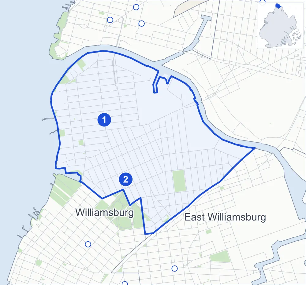
Greenpoint borders two areas, and Manhattan Avenue and Nassau Avenue hold more of its corners than any other street, 23 each of 212.
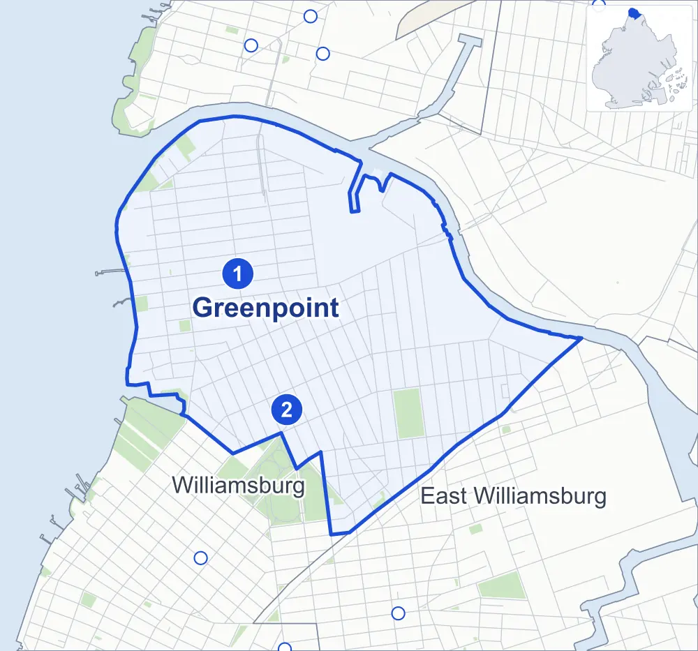
- Greenpoint
- A neighboring area
- Park
- A station in the list
- Another station
Neighborhood areas and streets: NYC Department of City Planning. Parks: NYC Parks. Stations: MTA.
Neighboring areas
- East Williamsburg southeast
- Williamsburg south
Subway stations
- Greenpoint Av lines G accessible
- Nassau Av lines G
Getting around
Two subway stations and buses on seven routes stop in or at the edge of Greenpoint.
- 2 subway stations
- 1 of them listed by the MTA as fully accessible
- 7 local bus routes
Local bus routes
- B24
- B32
- B43
- B48
- B62
- B94
- T403
Safety record
Between 2021 and 2025, its corners averaged fewer police-reported crashes than the average Brooklyn corner.
- 1,684 police-reported crashes at its corners
- 7.9 a corner, on average
- 10.5 the average Brooklyn corner
- 15 corners with a clean record
Signal or safety changes on City record, at 27 of its corners
- Leading pedestrian intervals
- 20
- Accessible pedestrian signals
- 13
- Turn calming
- 13
- Safety Improvement Projects
- 3
- Barnes Dance all-way crossings
- 1
Camera tickets
In 2025 its corners had more school-zone speed camera tickets than red-light or bus-lane tickets.
- 0 red-light camera tickets
- 1,669 school-zone speed camera tickets at five corners
- 0 bus-lane camera tickets
- Most speed tickets
- McGuinness Boulevard South & Broome Street, 542
People and homes
The 2020 Census counted 38,980 residents in Greenpoint, about 30,700 per square mile.
- 20,381 homes, 2020 Census
- 10,245 homes added since April 2010, net, by City Planning's count
Half of its 4,068 residential lots hold buildings from 1920 or earlier, and 90% of them date from before 1940, by the City's tax lot records.
Parks and landmarks
- Parkland
- 20.3 acres of NYC Parks property
- The largest pieces
- Msgr. McGolrick Park (9.1 acres), Newtown Barge Playground (2.6 acres) and Bushwick Inlet Park (1.7 acres)
- Designated landmarks
- Public School 34, the Winthrop Park Shelter Pavilion and the Astral Apartments
- Historic districts
- Eberhard Faber Pencil Company and Greenpoint, wholly or partly within Greenpoint
Streets and trees
- Trees
- 4,846 in NYC Parks' records, most often thornless honeylocust, London planetree and pin oak
- Street with the most corners
- Manhattan Avenue, with 23 of the area's 212
- Height above sea level
- From 5 feet at McGuinness Boulevard & Paidge Avenue to 44 feet at Meeker Avenue & Vandervoort Avenue at Apollo Street
- Honorary street names
- 4 at its corners, enacted by local law
Schools and libraries
The City lists seven schools and one library in Greenpoint.
- Public schools
- 5
- Charter and private schools
- 2
- Library
- Greenpoint Library and Environmental Education Center
Bike share and public art
By the station list of October 3, 2026, 29 bike-share stations stand in Greenpoint. The City's public art inventory lists four works in the area, among them Greenpoint War Memorial (1923), Monitor Memorial (1938) and Waterfront Nature Walk (2007).
- 29 bike-share stations
- 4 works of public art
Public safety
How complaints are countedIn 2025 the NYPD recorded 418 major felonies at places in Greenpoint.
Recorded by the NYPD at places in Greenpoint
- 442 major felonies in 2024
- 1,349 other felonies, misdemeanors and violations in 2025
In 2025, on the streets along the edge of Greenpoint, the NYPD recorded another 41 major felonies. Counting the streets along its edge, in 2025 the NYPD recorded 11.8 major felonies for every thousand residents the 2020 Census counted in Greenpoint.
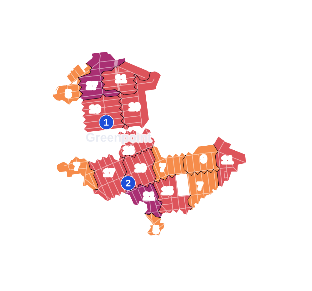
- 5 to 9
- 10 to 19
- 20 to 49
- 50 to 99
- 100 or more
- Not shaded: fewer than 5, held back under the rules in How complaints are counted, parks and public-housing grounds, and land in no patch
- Police precinct
- 94th
From January to June 2026 the NYPD recorded 169 major felonies at places in Greenpoint, against 217 in the same months of 2025.
Sources: the NYPD's Complaint Data Historic, updated April 28, 2026, and Complaint Data Current (Year To Date), updated July 27, 2026, on NYC Open Data. Figures to June 30, 2026.
Street corners
- Banker Street & North 15th Street
- Bayard Street & Brooklyn-Queens Expressway
- Bedford Avenue & Lorimer Street
- Bedford Avenue & Manhattan Avenue
- Bridgewater Street & Varick Street
- Calyer Street & Clifford Place
- Calyer Street & Diamond Street
- Calyer Street & Guernsey Street
- Calyer Street & Jewel Street
- Calyer Street & Moultrie Street
- Calyer Street & Newel Street
- Clay Street & Paidge Avenue
- Commercial Street & Bell Slip
- Commercial Street & Blue Slip
- Commercial Street & Box Street
- Commercial Street & Clay Street
- Driggs Avenue & Diamond Street
- Driggs Avenue & Eckford Street
- Driggs Avenue & Kingsland Avenue
- Driggs Avenue & McGuinness Boulevard
- Driggs Avenue & Monitor Street
- Driggs Avenue & Newel Street
- Driggs Avenue & North Henry Street
- Driggs Avenue & Russell Street
- Driggs Avenue & Sutton Street
- Dupont Street & Provost Street
- Eagle Street & Provost Street
- Eckford Street & Calyer Street
- Eckford Street & Engert Avenue
- Engert Avenue & McGuinness Boulevard South
- Engert Avenue & Newton Street
- Franklin Street & Calyer Street
- Franklin Street & Calyer Street at Banker Street
- Franklin Street & Commercial Street
- Franklin Street & Dupont Street
- Franklin Street & Eagle Street
- Franklin Street & Freeman Street
- Franklin Street & Green Street
- Franklin Street & Huron Street
- Franklin Street & India Street
- Franklin Street & Java Street
- Franklin Street & Kent Street
- Franklin Street & Meserole Avenue
- Franklin Street & Milton Street
- Franklin Street & Noble Street
- Franklin Street & North 15th Street
- Franklin Street & Oak Street
- Franklin Street & Quay Street
- Freeman Street & Provost Street
- Graham Avenue & Bayard Street
- Graham Avenue & Broome Street
- Graham Avenue & Driggs Avenue
- Graham Avenue & Engert Avenue
- Graham Avenue & McGuinness Boulevard
- Graham Avenue & Newton Street
- Green Street & Provost Street
- Greenpoint Avenue & Eckford Street
- Greenpoint Avenue & Franklin Street
- Greenpoint Avenue & Jewel Street
- Greenpoint Avenue & Kingsland Avenue
- Greenpoint Avenue & McGuinness Boulevard
- Greenpoint Avenue & Monitor Street
- Greenpoint Avenue & Moultrie Street
- Greenpoint Avenue & Newel Street
- Greenpoint Avenue & North Henry Street
- Greenpoint Avenue & Provost Street
- Greenpoint Avenue & Russell Street
- Greenpoint Avenue & West Street
- Humboldt Street & Bayard Street
- Humboldt Street & Broome Street
- Humboldt Street & Calyer Street
- Humboldt Street & Driggs Avenue
- Humboldt Street & Engert Avenue
- Humboldt Street & Greenpoint Avenue
- Humboldt Street & Meserole Avenue
- Humboldt Street & Nassau Avenue
- Humboldt Street & Norman Avenue
- Humboldt Street & Norman Avenue at Moultrie Street
- Huron Street & Provost Street
- India Street & Provost Street
- Java Street & Provost Street
- JJ Byrne Memorial Bridge & Greenpoint Avenue
- Kent Street & Provost Street
- Kingsland Avenue & Nassau Avenue
- Kingsland Avenue & Norman Avenue
- Kingsland Avenue & North Henry Street
- Leonard Street & Bayard Street
- Leonard Street & Calyer Street
- Leonard Street & Driggs Avenue
- Leonard Street & Greenpoint Avenue
- Leonard Street & Meserole Avenue
- Leonard Street & Nassau Avenue
- Leonard Street & Norman Avenue
- Lorimer Street & Calyer Street
- Lorimer Street & Meserole Avenue
- Lorimer Street & Noble Street
- Lorimer Street & Norman Avenue
- Manhattan Avenue & Bayard Street
- Manhattan Avenue & Box Street
- Manhattan Avenue & Calyer Street
- Manhattan Avenue & Clay Street
- Manhattan Avenue & Commercial Street
- Manhattan Avenue & Dupont Street
- Manhattan Avenue & Eagle Street
- Manhattan Avenue & Eckford Street
- Manhattan Avenue & Freeman Street
- Manhattan Avenue & Green Street
- Manhattan Avenue & Greenpoint Avenue
- Manhattan Avenue & Huron Street
- Manhattan Avenue & India Street
- Manhattan Avenue & Java Street
- Manhattan Avenue & Kent Street
- Manhattan Avenue & Leonard Street
- Manhattan Avenue & Meserole Avenue
- Manhattan Avenue & Milton Street
- Manhattan Avenue & Nassau Avenue
- Manhattan Avenue & Newton Street
- Manhattan Avenue & Noble Street
- Manhattan Avenue & Norman Avenue
- McGuinness Boulevard & Ash Street
- McGuinness Boulevard & Box Street
- McGuinness Boulevard & Calyer Street
- McGuinness Boulevard & Clay Street
- McGuinness Boulevard & Dupont Street
- McGuinness Boulevard & Eagle Street
- McGuinness Boulevard & Green Street
- McGuinness Boulevard & Huron Street
- McGuinness Boulevard & India Street
- McGuinness Boulevard & Java Street
- McGuinness Boulevard & Kent Street
- McGuinness Boulevard & Meserole Avenue
- McGuinness Boulevard & Nassau Avenue
- McGuinness Boulevard & Norman Avenue
- McGuinness Boulevard & Paidge Avenue
- McGuinness Boulevard South & Broome Street
- Meeker Avenue & Driggs Avenue
- Meeker Avenue & Hausman Street
- Meeker Avenue & Monitor Street
- Meeker Avenue & Vandervoort Avenue at Apollo Street
- Meeker Avenue & Varick Avenue
- Meserole Avenue & Banker Street
- Meserole Avenue & Diamond Street
- Meserole Avenue & Dobbin Street
- Meserole Avenue & Eckford Street
- Meserole Avenue & Gem Street
- Meserole Avenue & Guernsey Street
- Meserole Avenue & Jewel Street
- Meserole Avenue & Moultrie Street
- Meserole Avenue & Newel Street
- Monitor Street & Engert Avenue
- Monitor Street & Nassau Avenue
- Monitor Street & Norman Avenue
- Morgan Avenue & Driggs Avenue
- Morgan Avenue & Nassau Avenue
- Morgan Avenue & Norman Avenue
- Nassau Avenue & Apollo Street
- Nassau Avenue & Banker Street
- Nassau Avenue & Diamond Street
- Nassau Avenue & Dobbin Street
- Nassau Avenue & Eckford Street
- Nassau Avenue & Guernsey Street
- Nassau Avenue & Hausman Street
- Nassau Avenue & Jewel Street
- Nassau Avenue & Newel Street
- Nassau Avenue & North 15th Street
- Nassau Avenue & North Henry Street
- Nassau Avenue & Russell Street
- Nassau Avenue & Sutton Street
- Nassau Avenue & Van Dam Street
- Nassau Avenue & Varick Street
- Newton Street & McGuinness Boulevard South
- Norman Avenue & Apollo Street
- Norman Avenue & Diamond Street
- Norman Avenue & Dobbin Street
- Norman Avenue & Eckford Street
- Norman Avenue & Guernsey Street
- Norman Avenue & Hausman Street
- Norman Avenue & Jewel Street
- Norman Avenue & Newel Street
- Norman Avenue & Sutton Street
- North 15th Street & Gem Street
- North Henry Street & Engert Avenue
- North Henry Street & Meserole Avenue
- North Henry Street & Norman Avenue
- Oak Street & Wharf Drive
- Provost Street & Paidge Avenue
- Pulaski Bridge & Ash Street
- Pulaski Bridge & Box Street
- Pulaski Bridge & Clay Street
- Quay Street & Wharf Drive
- Russell Street & Calyer Street
- Russell Street & Engert Avenue
- Russell Street & Meserole Avenue
- Russell Street & Norman Avenue
- Van Dam Street & Bridgewater Street
- West Street & Calyer Street
- West Street & Commercial Street
- West Street & Eagle Street
- West Street & Freeman Street
- West Street & Green Street
- West Street & Huron Street
- West Street & India Street
- West Street & Java Street
- West Street & Kent Street
- West Street & Milton Street
- West Street & Noble Street
- West Street & Oak Street
- West Street & Quay Street
- West Street & Wharf Plaza
- Wharf Drive & Wharf Plaza
- Wythe Avenue & Norman Avenue
- Wythe Avenue & North 15th Street
How the figures above are measured: Methodology.