Bedford-Stuyvesant (East)
Neighborhood · Brooklyn
Stretching east to Broadway and the Bushwick line, the eastern half of Bedford-Stuyvesant covers the Brooklyn blocks between Flushing and Atlantic Avenues.
- 1.48 square miles
- 84,653 residents, 2020 Census
- 218 street corners
- 7 subway stations
- 19 bus routes
It takes in Stuyvesant Heights, named for Peter Stuyvesant, the last governor of New Netherland; the Stuyvesant Heights Historic District was designated in 1971 and greatly enlarged in 2013. The original district's more than 430 buildings range from freestanding houses of the 1860s and 1870s to rowhouses of the 1870s and 1880s and apartment houses of 1888 to 1903, many with stoops, bay windows and ironwork. In the 20th century Bedford-Stuyvesant became one of the largest and best-known Black neighborhoods in the United States.
Sources: Bedford–Stuyvesant, Brooklyn (Wikipedia); Brooklyn Landmarks-Stuyvesant Heights (Historic Districts Council); Bedford-Stuyvesant - Historic Districts Council's Six to Celebrate (Historic Districts Council); Stuyvesant Heights Historic District (NYC Landmarks Preservation Commission).
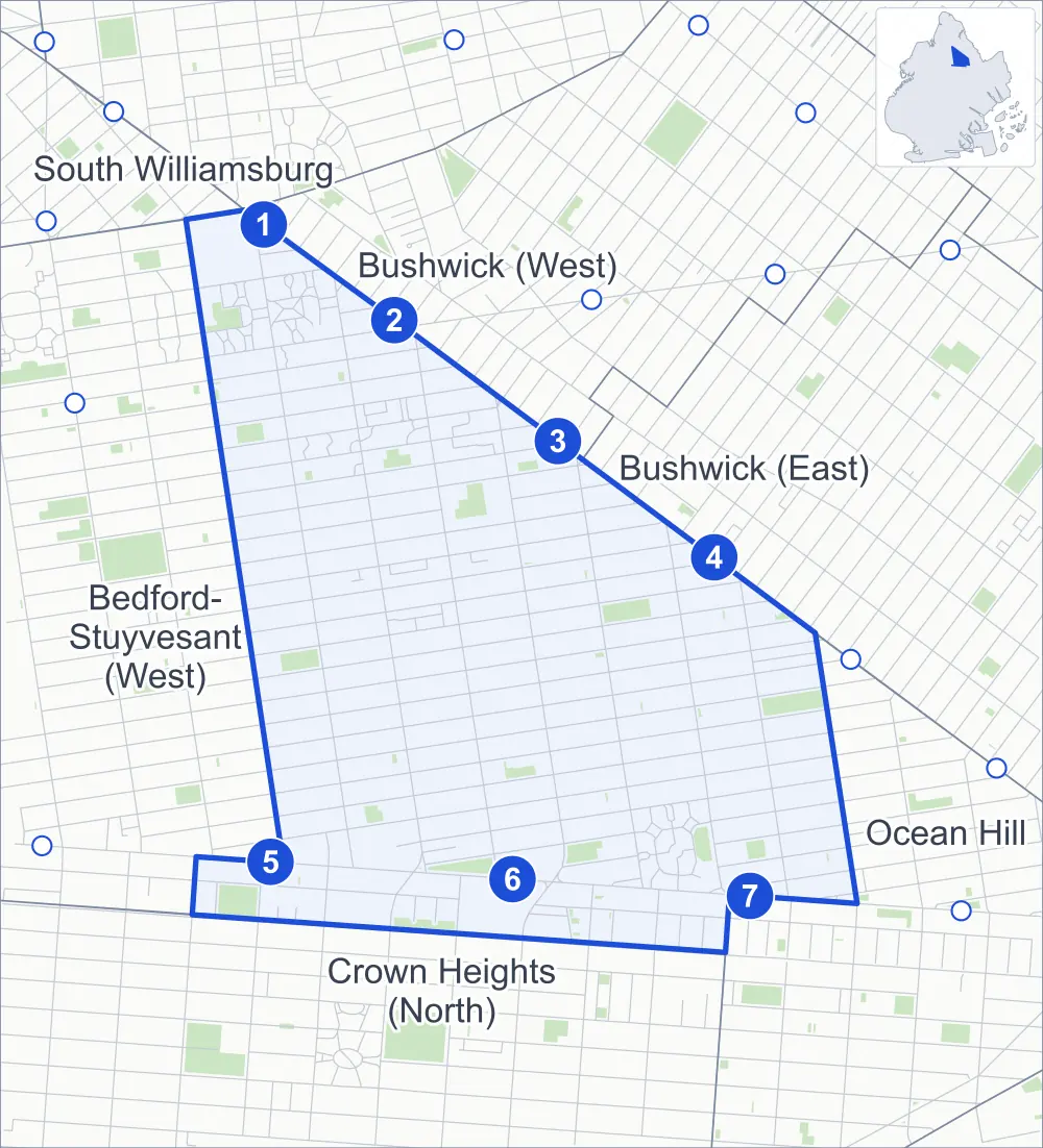
Bedford-Stuyvesant (East) borders six areas, and Lewis Avenue holds more of its corners than any other street, 27 of 218.
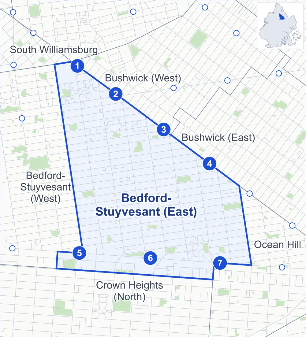
- Bedford-Stuyvesant (East)
- A neighboring area
- Park
- A station in the list
- Another station
Neighborhood areas and streets: NYC Department of City Planning. Parks: NYC Parks. Stations: MTA.
Neighboring areas
- Bushwick (West) north
- Bushwick (East) northeast
- Ocean Hill southeast
- Crown Heights (North) south
- Bedford-Stuyvesant (West) west
- South Williamsburg northwest
Subway stations
- Flushing Av lines J M accessible
- Myrtle Av lines J M Z
- Kosciuszko St lines J
- Gates Av lines J Z
- Kingston-Throop Avs lines C
- Utica Av lines A C accessible
- Ralph Av lines C
Getting around
Seven subway stations and buses on 19 routes stop in or at the edge of Bedford-Stuyvesant (East).
- 7 subway stations
- 2 of them listed by the MTA as fully accessible
- 19 local bus routes
Local bus routes
- B7
- B15
- B25
- B26
- B38
- B43
- B46
- B46-SBS
- B47
- B52
- B54
- B57
- M90
- Q24
- T410
- T430
- T432
- T433
- T440
Safety record
Between 2021 and 2025, its corners averaged more police-reported crashes than the average Brooklyn corner.
- 3,309 police-reported crashes at its corners
- 15.2 a corner, on average
- 10.5 the average Brooklyn corner
- 4 corners with a clean record
Signal or safety changes on City record, at 133 of its corners
- Leading pedestrian intervals
- 121
- Accessible pedestrian signals
- 30
- Turn calming
- 21
- Barnes Dance all-way crossings
- 3
- Safety Improvement Projects
- 1
Camera tickets
In 2025 its corners had more school-zone speed camera tickets than red-light or bus-lane tickets.
- 0 red-light camera tickets
- 9,886 school-zone speed camera tickets at 15 corners
- 0 bus-lane camera tickets
- Most speed tickets
- Lexington Avenue & Lewis Avenue, 1,753
People and homes
The 2020 Census counted 84,653 residents in Bedford-Stuyvesant (East), about 57,200 per square mile.
- 36,783 homes, 2020 Census
- 6,145 homes added since April 2010, net, by City Planning's count
Half of its 8,478 residential lots hold buildings from 1900 or earlier, and 83% of them date from before 1940, by the City's tax lot records.
NYCHA developments
NYCHA's Brevoort, Roosevelt I, Roosevelt II and Sumner developments lie wholly or partly within Bedford-Stuyvesant (East), as does one more that NYCHA names by a building's address.
Parks and landmarks
- Parkland
- 30.2 acres of NYC Parks property
- The largest pieces
- St. Andrew's Playground (3.5 acres), Saratoga Park (3.3 acres) and Jesse Owens Playground (2.3 acres)
- Designated landmarks
- The Antioch Baptist Church; and the Antioch Baptist Church, Church House
- Historic districts
- Alice and Agate Courts and Stuyvesant Heights, wholly or partly within Bedford-Stuyvesant (East)
Streets and trees
- Trees
- 6,766 in NYC Parks' records, most often London planetree, thornless honeylocust and pin oak
- Street with the most corners
- Lewis Avenue, with 27 of the area's 218
- Height above sea level
- From 31 feet at Broadway & Marcus Garvey Boulevard to 82 feet at Vernon Avenue & Lewis Avenue
- Honorary street names
- 8 at its corners, enacted by local law
Schools and libraries
The City lists 41 schools and one library in Bedford-Stuyvesant (East).
- Public schools
- 24
- Charter and private schools
- 17
- Library
- Macon Library
Bike share and public art
By the station list of October 3, 2026, 39 bike-share stations stand in Bedford-Stuyvesant (East). The City's public art inventory lists three works in the area: Robert Fulton (1872), Saratoga Park Memorial (1921) and Freedom's Gate (1997).
- 39 bike-share stations
- 3 works of public art
Public safety
How complaints are countedIn 2025 the NYPD recorded 926 major felonies at places in Bedford-Stuyvesant (East).
Recorded by the NYPD at places in Bedford-Stuyvesant (East)
- 922 major felonies in 2024
- 4,344 other felonies, misdemeanors and violations in 2025
In 2025, on the streets along the edge of Bedford-Stuyvesant (East), the NYPD recorded another 344 major felonies. Counting the streets along its edge, in 2025 the NYPD recorded 15.0 major felonies for every thousand residents the 2020 Census counted in Bedford-Stuyvesant (East).
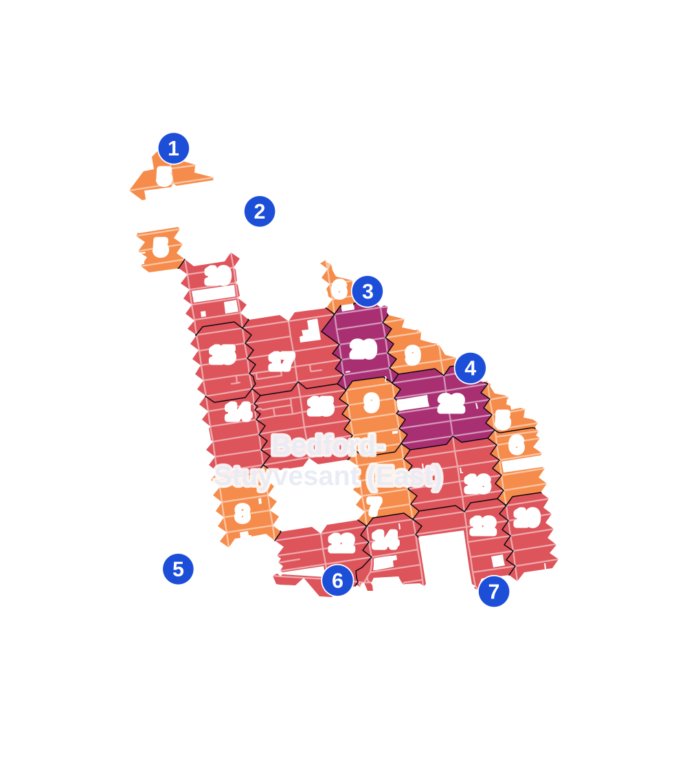
- 5 to 9
- 10 to 19
- 20 to 49
- 50 to 99
- 100 or more
- Not shaded: fewer than 5, held back under the rules in How complaints are counted, parks and public-housing grounds, and land in no patch
- Police precincts
- 81st (most of the area), 79th
From January to June 2026 the NYPD recorded 496 major felonies at places in Bedford-Stuyvesant (East), against 434 in the same months of 2025.
Sources: the NYPD's Complaint Data Historic, updated April 28, 2026, and Complaint Data Current (Year To Date), updated July 27, 2026, on NYC Open Data. Figures to June 30, 2026.
Street corners
- Albany Avenue & Decatur Street
- Albany Avenue & Herkimer Street
- Bainbridge Street & Malcolm X Boulevard
- Bainbridge Street & Patchen Avenue
- Broadway & Ditmars Street
- Broadway & Dodworth Street
- Broadway & Fayette Street
- Broadway & Hart Street
- Broadway & Kosciuszko Street
- Broadway & Kossuth Place
- Broadway & Malcolm X Boulevard
- Broadway & Malcolm X Boulevard at Lawton Street
- Broadway & Marcus Garvey Boulevard
- Broadway & Park Street
- Broadway & Quincy Street
- Broadway & Stuyvesant Avenue
- Broadway & Suydam Street
- Broadway & Vernon Avenue
- Broadway & Willoughby Avenue
- Chauncey Street & Lewis Avenue
- Chauncey Street & Malcolm X Boulevard
- Chauncey Street & Patchen Avenue
- Chauncey Street & Stuyvesant Avenue
- Decatur Street & Howard Avenue
- Decatur Street & Lewis Avenue
- Decatur Street & Malcolm X Boulevard
- Decatur Street & Marcus Garvey Boulevard
- Decatur Street & Patchen Avenue
- Decatur Street & Saratoga Avenue
- Decatur Street & Stuyvesant Avenue
- Decatur Street & Throop Avenue
- Dekalb Avenue & Broadway
- Dekalb Avenue & Lewis Avenue
- Dekalb Avenue & Malcolm X Boulevard
- Dekalb Avenue & Marcus Garvey Boulevard
- Dekalb Avenue & Stuyvesant Avenue
- Fulton Street & Albany Avenue
- Fulton Street & Buffalo Avenue
- Fulton Street & Howard Avenue
- Fulton Street & Hull Street
- Fulton Street & Lewis Avenue
- Fulton Street & MacDougal Street
- Fulton Street & Malcolm X Boulevard
- Fulton Street & Marcus Garvey Boulevard
- Fulton Street & Patchen Avenue
- Fulton Street & Ralph Avenue
- Fulton Street & Rochester Avenue
- Fulton Street & Schenectady Avenue
- Fulton Street & Stuyvesant Avenue
- Fulton Street & Sumpter Street
- Fulton Street & Throop Avenue
- Fulton Street & Tompkins Avenue
- Fulton Street & Troy Avenue
- Fulton Street & Utica Avenue
- Fulton Street & Utica Avenue at Malcolm X Boulevard
- Gates Avenue & Lewis Avenue
- Gates Avenue & Malcolm X Boulevard
- Gates Avenue & Marcus Garvey Boulevard
- Gates Avenue & Patchen Avenue
- Gates Avenue & Stuyvesant Avenue
- Gates Avenue & Throop Avenue
- Greene Avenue & Broadway
- Greene Avenue & Lewis Avenue
- Greene Avenue & Malcolm X Boulevard
- Greene Avenue & Marcus Garvey Boulevard
- Greene Avenue & Patchen Avenue
- Greene Avenue & Stuyvesant Avenue
- Halsey Street & Howard Avenue
- Halsey Street & Lewis Avenue
- Halsey Street & Malcolm X Boulevard
- Halsey Street & Marcus Garvey Boulevard
- Halsey Street & Patchen Avenue
- Halsey Street & Saratoga Avenue
- Halsey Street & Stuyvesant Avenue
- Halsey Street & Throop Avenue
- Hancock Street & Howard Avenue
- Hancock Street & Lewis Avenue
- Hancock Street & Malcolm X Boulevard
- Hancock Street & Marcus Garvey Boulevard
- Hancock Street & Patchen Avenue
- Hancock Street & Saratoga Avenue
- Hancock Street & Stuyvesant Avenue
- Hancock Street & Throop Avenue
- Hart Street & Lewis Avenue
- Hart Street & Marcus Garvey Boulevard
- Hart Street & Stuyvesant Avenue
- Hart Street & Throop Avenue
- Herkimer Street & Buffalo Avenue
- Herkimer Street & Columbus Place
- Herkimer Street & Hattie Jones Place
- Herkimer Street & Hunterfly Place
- Herkimer Street & Jewell McKoy Lane
- Herkimer Street & Kane Place
- Herkimer Street & Kingston Avenue
- Herkimer Street & Rochester Avenue
- Herkimer Street & St Andrews Place
- Herkimer Street & Suydam Place
- Howard Avenue & Bainbridge Street
- Howard Avenue & Chauncey Street
- Howard Avenue & MacDougal Street
- Howard Avenue & Marion Street
- Howard Avenue & Sumpter Street
- Jefferson Avenue & Howard Avenue
- Jefferson Avenue & Lewis Avenue
- Jefferson Avenue & Malcolm X Boulevard
- Jefferson Avenue & Marcus Garvey Boulevard
- Jefferson Avenue & Patchen Avenue
- Jefferson Avenue & Stuyvesant Avenue
- Jefferson Avenue & Throop Avenue
- Kosciuszko Street & Lewis Avenue
- Kosciuszko Street & Malcolm X Boulevard
- Kosciuszko Street & Marcus Garvey Boulevard
- Kosciuszko Street & Stuyvesant Avenue
- Kosciuszko Street & Throop Avenue
- Lafayette Avenue & Broadway
- Lafayette Avenue & Lewis Avenue
- Lafayette Avenue & Malcolm X Boulevard
- Lafayette Avenue & Marcus Garvey Boulevard
- Lafayette Avenue & Patchen Avenue
- Lafayette Avenue & Stuyvesant Avenue
- Lewis Avenue & Bainbridge Street
- Lewis Avenue & Pulaski Street
- Lewis Avenue & Stockton Street
- Lewis Avenue & Van Buren Street
- Lexington Avenue & Lewis Avenue
- Lexington Avenue & Malcolm X Boulevard
- Lexington Avenue & Marcus Garvey Boulevard
- Lexington Avenue & Patchen Avenue
- Lexington Avenue & Stuyvesant Avenue
- Lexington Avenue & Throop Avenue
- MacDonough Street & Howard Avenue
- MacDonough Street & Lewis Avenue
- MacDonough Street & Malcolm X Boulevard
- MacDonough Street & Marcus Garvey Boulevard
- MacDonough Street & Patchen Avenue
- MacDonough Street & Stuyvesant Avenue
- MacDonough Street & Throop Avenue
- Macon Street & Howard Avenue
- Macon Street & Lewis Avenue
- Macon Street & Malcolm X Boulevard
- Macon Street & Marcus Garvey Boulevard
- Macon Street & Patchen Avenue
- Macon Street & Stuyvesant Avenue
- Macon Street & Throop Avenue
- Madison Street & Howard Avenue
- Madison Street & Lewis Avenue
- Madison Street & Malcolm X Boulevard
- Madison Street & Marcus Garvey Boulevard
- Madison Street & Patchen Avenue
- Madison Street & Stuyvesant Avenue
- Madison Street & Throop Avenue
- Malcolm X Boulevard & Marion Street
- Marcus Garvey Boulevard & Ellery Street
- Marcus Garvey Boulevard & Pulaski Street
- Marcus Garvey Boulevard & Van Buren Street
- Marcus Garvey Boulevard & Vernon Avenue
- Marion Street & Patchen Avenue
- Monroe Street & Howard Avenue
- Monroe Street & Lewis Avenue
- Monroe Street & Malcolm X Boulevard
- Monroe Street & Marcus Garvey Boulevard
- Monroe Street & Patchen Avenue
- Monroe Street & Stuyvesant Avenue
- Monroe Street & Throop Avenue
- Myrtle Avenue & Broadway
- Myrtle Avenue & Lewis Avenue
- Myrtle Avenue & Marcus Garvey Boulevard
- Park Avenue & Marcus Garvey Boulevard
- Pulaski Street & Malcolm X Boulevard
- Putnam Avenue & Howard Avenue
- Putnam Avenue & Lewis Avenue
- Putnam Avenue & Malcolm X Boulevard
- Putnam Avenue & Marcus Garvey Boulevard
- Putnam Avenue & Patchen Avenue
- Putnam Avenue & Stuyvesant Avenue
- Putnam Avenue & Throop Avenue
- Quincy Street & Lewis Avenue
- Quincy Street & Malcolm X Boulevard
- Quincy Street & Marcus Garvey Boulevard
- Quincy Street & Patchen Avenue
- Quincy Street & Stuyvesant Avenue
- Quincy Street & Throop Avenue
- Ralph Avenue & Bainbridge Street
- Ralph Avenue & Chauncey Street
- Ralph Avenue & Decatur Street
- Ralph Avenue & Gates Avenue
- Ralph Avenue & Halsey Street
- Ralph Avenue & Hancock Street
- Ralph Avenue & Herkimer Street
- Ralph Avenue & Jefferson Avenue
- Ralph Avenue & MacDonough Street
- Ralph Avenue & MacDougal Street
- Ralph Avenue & Macon Street
- Ralph Avenue & Madison Street
- Ralph Avenue & Marion Street
- Ralph Avenue & Monroe Street
- Ralph Avenue & Putnam Avenue
- Ralph Avenue & Quincy Street
- Ralph Avenue & Sumpter Street
- Saratoga Avenue & Chauncey Street
- Saratoga Avenue & Hull Street
- Saratoga Avenue & MacDonough Street
- Saratoga Avenue & Sumpter Street
- Schenectady Avenue & Herkimer Street
- Stuyvesant Avenue & Bainbridge Street
- Stuyvesant Avenue & Pulaski Street
- Stuyvesant Avenue & Van Buren Street
- Sumpter Street & Patchen Avenue
- Throop Avenue & Vernon Avenue
- Troy Avenue & Herkimer Street
- Utica Avenue & Herkimer Street
- Van Buren Street & Malcolm X Boulevard
- Van Buren Street & Patchen Avenue
- Vernon Avenue & Lewis Avenue
- Vernon Avenue & Stuyvesant Avenue
- Willoughby Avenue & Lewis Avenue
- Willoughby Avenue & Marcus Garvey Boulevard
- Willoughby Avenue & Stuyvesant Avenue
How the figures above are measured: Methodology.