Queensboro Hill
Neighborhood · Queens
Named for the county of Queens, Queensboro Hill lies between College Point Boulevard on the west and the Long Island Expressway on the south, with Kissena Park and Kissena Corridor Park to the north, and it is often called South Flushing.
- 0.95 square miles
- 23,638 residents, 2020 Census
- 190 street corners
- 11 bus routes
NewYork-Presbyterian Queens on Main Street opened here on February 5, 1957, as the Salvation Army's 210-bed Booth Memorial Hospital, whose roots went back to an 1892 home for women in East Harlem. Around then, North Hempstead Turnpike was renamed Booth Memorial Avenue, which runs through the neighborhood. The hospital took its present name in 2015.
Sources: Flushing, Queens (Wikipedia); The Names of the Neighborhoods of Queens, Part 2 (Forgotten New York); NewYork-Presbyterian Queens (Wikipedia).
Queensboro Hill borders nine areas, and Horace Harding Expressway holds more of its corners than any other street, 32 of 190.
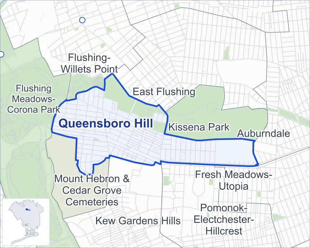
- Queensboro Hill
- A neighboring area
- Park
- Another station
Neighborhood areas and streets: NYC Department of City Planning. Parks: NYC Parks. Stations: MTA.
Neighboring areas
- East Flushing north
- Kissena Park east
- Fresh Meadows-Utopia east
- Auburndale east
- Pomonok-Electchester-Hillcrest southeast
- Kew Gardens Hills south
- Mount Hebron & Cedar Grove Cemeteries west
- Flushing Meadows-Corona Park west
- Flushing-Willets Point northwest
Getting around
Buses on 11 routes stop in or at the edge of Queensboro Hill.
- 9 local bus routes
- 2 express bus routes
Local bus routes
- Q17
- Q20
- Q25
- Q44-SBS
- Q58
- Q65
- Q74
- Q88
- Q98
Express bus routes
- QM4
- QM44
Safety record
Between 2021 and 2025, its corners averaged more police-reported crashes than the average Queens corner.
- 1,021 police-reported crashes at its corners
- 5.4 a corner, on average
- 5.2 the average Queens corner
- 27 corners with a clean record
Signal or safety changes on City record, at 17 of its corners
- Leading pedestrian intervals
- 9
- Accessible pedestrian signals
- 5
- Turn calming
- 4
- Safety Improvement Projects
- 2
- Barnes Dance all-way crossings
- 1
Camera tickets
In 2025 its corners had more school-zone speed camera tickets than bus-lane or red-light tickets.
- 583 red-light camera tickets at one corner
- 17,754 school-zone speed camera tickets at nine corners
- 2,233 bus-lane camera tickets at one corner
- Most red-light tickets
- Kissena Boulevard & Booth Memorial Avenue, 583
- Most speed tickets
- Main Street & 146th Street, 7,452
- Most bus-lane tickets
- Main Street & Booth Memorial Avenue, 2,233
People and homes
The 2020 Census counted 23,638 residents in Queensboro Hill, about 24,900 per square mile.
- 7,558 homes, 2020 Census
- 553 homes added since April 2010, net, by City Planning's count
Half of its 4,180 residential lots hold buildings from 1950 or earlier, and 20% of them date from before 1940, by the City's tax lot records.
Parks
- Parkland
- 70.6 acres of Kissena Corridor Park, as NYC Parks maps it within Queensboro Hill
Streets and trees
- Trees
- 3,370 in NYC Parks' records, most often London planetree, thornless honeylocust and pin oak
- Street with the most corners
- Horace Harding Expressway, with 32 of the area's 190
- Height above sea level
- From 10 feet at College Point Boulevard & 57th Road to 82 feet at 164th Street & 59th Avenue
- Honorary street name
- 1 at its corners, enacted by local law
Schools and libraries
The City lists three schools and one library in Queensboro Hill.
- Public schools
- 2
- Charter or private school
- 1
- Library
- Queensboro Hill Library
Public safety
How complaints are countedIn 2025 the NYPD recorded 262 major felonies at places in Queensboro Hill.
Recorded by the NYPD at places in Queensboro Hill
- 226 major felonies in 2024
- 444 other felonies, misdemeanors and violations in 2025
In 2025, on the streets along the edge of Queensboro Hill, the NYPD recorded another 42 major felonies. Counting the streets along its edge, in 2025 the NYPD recorded 12.9 major felonies for every thousand residents the 2020 Census counted in Queensboro Hill.
- Police precincts
- 109th (most of the area), 107th
From January to June 2026 the NYPD recorded 87 major felonies at places in Queensboro Hill, against 116 in the same months of 2025.
Sources: the NYPD's Complaint Data Historic, updated April 28, 2026, and Complaint Data Current (Year To Date), updated July 27, 2026, on NYC Open Data. Figures to June 30, 2026.
Street corners
- 45th Avenue & Colden Street
- 56th Avenue & 137th Street
- 56th Avenue & 138th Street
- 56th Avenue & 141st Street
- 56th Avenue & 152nd Street
- 56th Avenue & 153rd Street
- 56th Avenue & Kissena Boulevard
- 56th Avenue & Main Street
- 57th Avenue & 136th Street
- 57th Avenue & Lawrence Street
- 57th Road & Lawrence Street
- 58th Avenue & 134th Street
- 58th Avenue & 136th Street
- 58th Avenue & 138th Street
- 58th Avenue & 141st Street
- 58th Avenue & 142nd Street
- 58th Avenue & 146th Street
- 58th Avenue & 148th Street
- 58th Avenue & 153rd Street
- 58th Avenue & 155th Street
- 58th Avenue & Kissena Boulevard
- 58th Avenue & Lawrence Street
- 58th Avenue & Main Street
- 58th Road & 136th Street
- 58th Road & Lawrence Street
- 59th Avenue & 136th Street
- 59th Avenue & 138th Street
- 59th Avenue & 142nd Street
- 59th Avenue & 153rd Street
- 59th Avenue & 154th Place
- 59th Avenue & 156th Street
- 59th Avenue & 163rd Street
- 59th Avenue & Fresh Meadow Lane
- 59th Avenue & Kissena Boulevard
- 59th Avenue & Lawrence Street
- 60th Avenue & 136th Street
- 60th Avenue & 138th Street
- 60th Avenue & 142nd Street
- 60th Avenue & 153rd Street
- 60th Avenue & Kissena Boulevard
- 60th Avenue & Lawrence Street
- 61st Road & 146th Place
- 61st Road & 148th Place
- 61st Road & Reeves Avenue
- 62nd Avenue & 136th Street
- 63rd Avenue & 136th Street
- 63rd Avenue & 137th Street
- 64th Avenue & 63rd Avenue
- 64th Avenue & 136th Street
- 64th Avenue & 137th Street
- 64th Avenue & 138th Street
- 64th Road & 137th Street
- 134th Street & 57th Avenue
- 134th Street & 57th Road
- 134th Street & 58th Road
- 134th Street & 133rd Street
- 134th Street & Booth Memorial Avenue
- 135th Street & Booth Memorial Avenue
- 136th Street & 57th Road
- 136th Street & 61st Road
- 136th Street & 62nd Road
- 136th Street & 63rd Road
- 136th Street & Elder Avenue
- 138th Street & 57th Road
- 138th Street & 58th Road
- 138th Street & 61st Road
- 138th Street & 62nd Avenue
- 138th Street & 62nd Road
- 138th Street & 63rd Avenue
- 138th Street & Booth Memorial Avenue
- 141st Street & Booth Memorial Avenue
- 142nd Street & 56th Road
- 142nd Street & 58th Road
- 146th Street & 56th Road
- 146th Street & 58th Road
- 146th Street & 59th Avenue
- 146th Street & 60th Avenue
- 146th Street & 61st Road
- 146th Street & Booth Memorial Avenue
- 146th Street & Reeves Avenue
- 148th Street & 56th Road
- 148th Street & 58th Road
- 148th Street & 59th Avenue
- 148th Street & 60th Avenue
- 148th Street & 61st Road
- 148th Street & Booth Memorial Avenue
- 149th Street & 61st Road
- 149th Street & Reeves Avenue
- 150th Street & 58th Avenue
- 150th Street & 58th Road
- 150th Street & 59th Avenue
- 150th Street & 60th Avenue
- 150th Street & 61st Road
- 150th Street & Booth Memorial Avenue
- 150th Street & Reeves Avenue
- 153rd Street & 58th Road
- 153rd Street & 61st Road
- 153rd Street & Booth Memorial Avenue
- 153rd Street & Peck Avenue
- 155th Street & 58th Road
- 155th Street & 59th Avenue
- 155th Street & Booth Memorial Avenue
- 156th Street & Booth Memorial Avenue
- 157th Street & 59th Avenue
- 157th Street & Booth Memorial Avenue
- 159th Street & 59th Avenue
- 159th Street & Booth Memorial Avenue
- 160th Street & 59th Avenue
- 160th Street & Booth Memorial Avenue
- 161st Street & 59th Avenue
- 161st Street & Booth Memorial Avenue
- 162nd Street & 59th Avenue
- 162nd Street & Booth Memorial Avenue
- 163rd Street & Booth Memorial Avenue
- 164th Street & 59th Avenue
- 164th Street & Booth Memorial Avenue
- Booth Memorial Avenue & 133rd Street
- Booth Memorial Avenue & 136th Street
- Booth Memorial Avenue & 137th Street
- Booth Memorial Avenue & 142nd Street
- Booth Memorial Avenue & Fresh Meadow Lane
- Colden Street & Geranium Avenue
- Colden Street & Kalmia Avenue
- Colden Street & Mulberry Avenue
- Colden Street & Oak Avenue
- College Point Boulevard & 57th Road
- College Point Boulevard & 58th Road
- College Point Boulevard & 59th Avenue
- College Point Boulevard & 60th Avenue
- College Point Boulevard & Booth Memorial Avenue at Lawrence Street
- College Point Boulevard & Van Wyck Expressway
- Elder Avenue & Byrd Street
- Horace Harding Expressway & 61st Road
- Horace Harding Expressway & 134th Street
- Horace Harding Expressway & 135th Street
- Horace Harding Expressway & 136th Street
- Horace Harding Expressway & 138th Street
- Horace Harding Expressway & 138th Street at Long Island Expressway
- Horace Harding Expressway & 142nd Street
- Horace Harding Expressway & 146th Street
- Horace Harding Expressway & 148th Street
- Horace Harding Expressway & 150th Street
- Horace Harding Expressway & 153rd Street
- Horace Harding Expressway & 154th Place
- Horace Harding Expressway & 156th Street
- Horace Harding Expressway & 157th Street
- Horace Harding Expressway & 161st Street
- Horace Harding Expressway & 169th Street at Long Island Expressway
- Horace Harding Expressway & College Point Boulevard
- Horace Harding Expressway & Fresh Meadow Lane at Fresh Meadow Lane Pedestrian Overpass
- Horace Harding Expressway & Kissena Boulevard
- Horace Harding Expressway & Lawrence Street
- Horace Harding Expressway & Long Island Expressway (College Pnt Boulevard)
- Horace Harding Expressway & Long Island Expressway (Exit 22B)
- Horace Harding Expressway & Long Island Expressway (Exit 23)
- Horace Harding Expressway & Long Island Expressway (Exit 24, east)
- Horace Harding Expressway & Long Island Expressway (Exit 24, west)
- Horace Harding Expressway & Long Island Expressway (Kissena Boulevard)
- Horace Harding Expressway & Long Island Expressway (Main Street, north-west)
- Horace Harding Expressway & Long Island Expressway (Main Street, south-east)
- Horace Harding Expressway & Main Street
- Horace Harding Expressway & Main Street at 61st Road
- Horace Harding Expressway & Reeves Avenue
- Horace Harding Expressway & Thompson Place
- Kissena Boulevard & 58th Road
- Kissena Boulevard & 152nd Street
- Kissena Boulevard & Booth Memorial Avenue
- Kissena Boulevard & Peck Avenue
- Kissena Boulevard & Poplar Avenue
- Kissena Boulevard & Rose Avenue
- Long Island Expressway & 136th Street Pedestrian Overpass
- Long Island Expressway & 148th Street Pedestrian Overpass
- Long Island Expressway & Main Street
- Main Street & 57th Road
- Main Street & 58th Road
- Main Street & 59th Avenue
- Main Street & 60th Avenue
- Main Street & 61st Road
- Main Street & 62nd Avenue
- Main Street & 62nd Road
- Main Street & 142nd Street
- Main Street & 146th Street
- Main Street & Booth Memorial Avenue
- Main Street & Elder Avenue
- Main Street & Peck Avenue
- Main Street & Reeves Avenue
- Parsons Boulevard & 59th Avenue
- Parsons Boulevard & Booth Memorial Avenue
- Peck Avenue & 137th Street
- Peck Avenue & 152nd Street
How the figures above are measured: Methodology.