Auburndale
Neighborhood · Queens
Auburndale sits between Flushing's Murray Hill section and Bayside, and both the Clearview Expressway and the Long Island Expressway pass through it.
- 1.99 square miles
- 36,182 residents, 2020 Census
- 436 street corners
- 14 bus routes
Developer L. H. Green started the community in 1901, the year Long Island Rail Road service reached the area, and it takes its name from his home of Auburndale, Massachusetts. Its Auburndale station on the Port Washington Branch still links the neighborhood with Manhattan. Tudor houses are the most common style, mixed with Dutch colonials and Cape Cods, and the area's largest public high school is Francis Lewis High School.
Sources: Auburndale, Queens (Wikipedia); The Names of the Neighborhoods of Queens, Part 2 (Forgotten New York).
Auburndale borders eight areas, and Francis Lewis Boulevard and Utopia Parkway hold more of its corners than any other street, 28 each of 436.
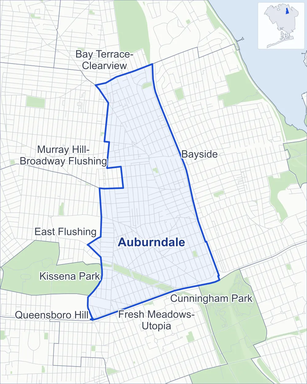
- Auburndale
- A neighboring area
- Park
Neighborhood areas and streets: NYC Department of City Planning. Parks: NYC Parks. Stations: MTA.
Neighboring areas
- Bay Terrace-Clearview north
- Bayside northeast
- Cunningham Park southeast
- Fresh Meadows-Utopia south
- East Flushing southwest
- Kissena Park southwest
- Queensboro Hill southwest
- Murray Hill-Broadway Flushing northwest
Getting around
Buses on 14 routes stop in or at the edge of Auburndale.
- 13 local bus routes
- 1 express bus route
Local bus routes
- Q12
- Q13
- Q16
- Q17
- Q26
- Q27
- Q28
- Q30
- Q31
- Q74
- Q75
- Q76
- Q88
Express bus route
- QM20
Safety record
Between 2021 and 2025, its corners averaged fewer police-reported crashes than the average Queens corner.
- 1,155 police-reported crashes at its corners
- 2.6 a corner, on average
- 5.2 the average Queens corner
- 147 corners with a clean record
Signal or safety changes on City record, at 24 of its corners
- Leading pedestrian intervals
- 19
- Accessible pedestrian signals
- 15
- Safety Improvement Projects
- 1
Camera tickets
In 2025 its corners had more school-zone speed camera tickets than red-light or bus-lane tickets.
- 0 red-light camera tickets
- 28,398 school-zone speed camera tickets at 27 corners
- 0 bus-lane camera tickets
- Most speed tickets
- Clearview Expressway & 56th Avenue, 3,662
People and homes
The 2020 Census counted 36,182 residents in Auburndale, about 18,200 per square mile.
- 13,045 homes, 2020 Census
- 323 homes added since April 2010, net, by City Planning's count
Half of its 8,225 residential lots hold buildings from 1945 or earlier, and 27% of them date from before 1940, by the City's tax lot records.
Parks
- Parkland
- 29.7 acres of NYC Parks property
- The largest pieces
- Kissena Corridor Park (24.3 acres), Bayside Fields (2.6 acres) and Saul Weprin Playground (1.5 acres)
Streets and trees
- Trees
- 7,933 in NYC Parks' records, most often London planetree, pin oak and Japanese flowering cherry
- Street with the most corners
- Francis Lewis Boulevard, with 28 of the area's 436
- Height above sea level
- From 28 feet at 50th Avenue & 175th Place to 113 feet at 201st Street & 26th Avenue
- Honorary street names
- 5 at its corners, enacted by local law
Schools and libraries
The City lists 12 schools and one library in Auburndale.
- Public schools
- 7
- Charter and private schools
- 5
- Library
- East Flushing Library
Public safety
How complaints are countedIn 2025 the NYPD recorded 370 major felonies at places in Auburndale.
Recorded by the NYPD at places in Auburndale
- 353 major felonies in 2024
- 620 other felonies, misdemeanors and violations in 2025
In 2025, on the streets along the edge of Auburndale, the NYPD recorded another 20 major felonies. Counting the streets along its edge, in 2025 the NYPD recorded 10.8 major felonies for every thousand residents the 2020 Census counted in Auburndale.
- Police precincts
- 111th (most of the area), 109th
From January to June 2026 the NYPD recorded 171 major felonies at places in Auburndale, against 160 in the same months of 2025.
Sources: the NYPD's Complaint Data Historic, updated April 28, 2026, and Complaint Data Current (Year To Date), updated July 27, 2026, on NYC Open Data. Figures to June 30, 2026.
Street corners
- 26th Avenue & 200th Street
- 26th Avenue & 203rd Street
- 26th Avenue & 205th Street
- 26th Avenue & 206th Street
- 27th Avenue & 200th Street
- 27th Avenue & 203rd Street
- 27th Avenue & 206th Street
- 28th Avenue & 200th Street
- 28th Avenue & 203rd Street
- 28th Avenue & 206th Street
- 28th Avenue & Jordan Street
- 29th Avenue & 200th Street
- 29th Avenue & 203rd Street
- 29th Avenue & 206th Street
- 29th Avenue & Jordan Street
- 30th Avenue & Jordan Street
- 32nd Avenue & 172nd Street
- 32nd Avenue & 200th Street
- 32nd Avenue & 201st Street
- 32nd Avenue & 202nd Street
- 32nd Avenue & 203rd Street
- 32nd Avenue & 204th Street
- 32nd Avenue & 205th Street
- 32nd Avenue & Jordan Street
- 32nd Avenue & Utopia Parkway
- 33rd Avenue & 190th Street
- 33rd Avenue & 191st Street
- 33rd Avenue & 200th Street
- 33rd Avenue & 203rd Street
- 33rd Avenue & 205th Street
- 33rd Avenue & Jordan Street
- 34th Avenue & 192nd Street
- 34th Avenue & 200th Street
- 34th Avenue & 201st Street
- 34th Avenue & 202nd Street
- 34th Avenue & 203rd Street
- 34th Avenue & 204th Street
- 34th Avenue & 205th Street
- 34th Avenue & Jordan Street
- 35th Avenue & 190th Street
- 35th Avenue & 191st Street
- 35th Avenue & 192nd Street
- 35th Avenue & 200th Street
- 35th Avenue & 201st Street
- 35th Avenue & 202nd Street
- 35th Avenue & 203rd Street
- 35th Avenue & 204th Street
- 35th Avenue & 205th Street
- 35th Avenue & Utopia Parkway
- 36th Avenue & 200th Street
- 36th Avenue & 205th Street
- 37th Avenue & 190th Street
- 37th Avenue & 191st Street
- 37th Avenue & 192nd Street
- 37th Avenue & 193rd Street
- 37th Avenue & 194th Street
- 37th Avenue & 195th Street
- 37th Avenue & Utopia Parkway
- 38th Avenue & 201st Street
- 38th Avenue & 203rd Street
- 38th Avenue & 204th Street
- 38th Avenue & 205th Street
- 39th Avenue & 190th Street
- 39th Avenue & 191st Street
- 39th Avenue & 192nd Street
- 39th Avenue & 194th Street
- 39th Avenue & 195th Street
- 39th Avenue & 203rd Street
- 39th Avenue & 204th Street
- 39th Avenue & 205th Street
- 42nd Avenue & 191st Street
- 42nd Avenue & 205th Street
- 43rd Avenue & 201st Street
- 43rd Avenue & 202nd Street
- 43rd Avenue & 203rd Street
- 43rd Avenue & 204th Street
- 43rd Avenue & 205th Street
- 45th Avenue & 172nd Street
- 45th Avenue & 189th Street
- 45th Avenue & 192nd Street
- 45th Avenue & 193rd Street
- 45th Avenue & 195th Street
- 45th Avenue & 196th Street
- 45th Avenue & 203rd Street
- 45th Avenue & 204th Street
- 45th Drive & 196th Place
- 45th Road & 196th Place
- 46th Avenue & 189th Street
- 46th Avenue & 192nd Street
- 46th Avenue & 193rd Street
- 46th Avenue & 195th Street
- 46th Avenue & 196th Place
- 46th Avenue & 196th Street
- 46th Avenue & 197th Street
- 46th Avenue & 204th Street
- 46th Avenue & Auburndale Lane
- 47th Avenue & 188th Street
- 47th Avenue & 189th Street
- 47th Avenue & 190th Street
- 47th Avenue & 192nd Street
- 47th Avenue & 193rd Street
- 47th Avenue & 194th Street
- 47th Avenue & 195th Street
- 47th Avenue & 196th Place
- 47th Avenue & 196th Street
- 47th Avenue & 197th Street
- 47th Avenue & 202nd Street
- 47th Avenue & 204th Street
- 47th Avenue & Fresh Meadow Lane
- 47th Avenue & Hollis Court Boulevard (north-west)
- 47th Avenue & Hollis Court Boulevard (south-east)
- 47th Avenue & Rocky Hill Road
- 47th Avenue & Utopia Parkway
- 47th Road & Rocky Hill Road
- 48th Avenue & 187th Street
- 48th Avenue & 188th Street
- 48th Avenue & 189th Street
- 48th Avenue & 190th Street
- 48th Avenue & 192nd Street
- 48th Avenue & 193rd Street
- 48th Avenue & 195th Street
- 48th Avenue & 196th Place
- 48th Avenue & 196th Street
- 48th Avenue & 197th Street
- 48th Avenue & 198th Street
- 48th Avenue & 201st Street
- 48th Avenue & 203rd Street
- 48th Avenue & Hollis Court Boulevard
- 48th Avenue & Weeks Lane
- 49th Avenue & 196th Place
- 49th Avenue & Weeks Lane
- 50th Avenue & 175th Place
- 50th Avenue & 175th Street
- 50th Avenue & 185th Street
- 50th Avenue & 188th Street
- 50th Avenue & 189th Street
- 50th Avenue & 190th Street
- 50th Avenue & 192nd Street
- 50th Avenue & 193rd Street
- 50th Avenue & 195th Street
- 50th Avenue & 196th Place
- 50th Avenue & 196th Street
- 50th Avenue & 199th Street
- 50th Avenue & 201st Street
- 50th Avenue & 203rd Street
- 50th Avenue & Hollis Court Boulevard
- 50th Avenue & Peck Avenue
- 50th Avenue & Underhill Avenue
- 50th Avenue & Weeks Lane
- 51st Avenue & 196th Street
- 51st Avenue & 199th Street
- 51st Avenue & Hollis Court Boulevard
- 51st Avenue & Weeks Lane
- 53rd Avenue & 188th Street
- 53rd Avenue & 189th Street
- 53rd Avenue & 190th Street
- 53rd Avenue & 192nd Street
- 53rd Avenue & 193rd Street
- 53rd Avenue & 195th Street
- 53rd Avenue & 196th Street
- 53rd Avenue & 197th Street
- 53rd Avenue & 198th Street
- 53rd Avenue & 199th Street
- 53rd Avenue & 201st Street
- 53rd Avenue & 203rd Street
- 53rd Avenue & Hollis Court Boulevard
- 56th Avenue & 174th Street
- 56th Avenue & 175th Place
- 56th Avenue & 175th Street
- 56th Avenue & 184th Street
- 56th Avenue & 185th Street
- 56th Avenue & 186th Street
- 56th Avenue & 187th Street
- 56th Avenue & 188th Street
- 56th Avenue & 192nd Street
- 56th Avenue & 193rd Street
- 56th Avenue & 194th Street
- 56th Avenue & 195th Street
- 56th Avenue & 196th Place
- 56th Avenue & 196th Street
- 56th Avenue & 198th Street
- 56th Avenue & 199th Street
- 56th Avenue & 201st Street
- 56th Avenue & 202nd Street
- 56th Avenue & 203rd Street
- 56th Avenue & Fresh Meadow Lane
- 56th Avenue & Hollis Court Boulevard
- 56th Avenue & Peck Avenue
- 56th Avenue & Underhill Avenue
- 56th Avenue & Utopia Parkway
- 58th Avenue & 183rd Street
- 58th Avenue & 184th Street
- 58th Avenue & 185th Street
- 58th Avenue & 186th Street
- 58th Avenue & 187th Street
- 58th Avenue & 188th Street
- 58th Avenue & 189th Street
- 58th Avenue & 190th Street
- 58th Avenue & 192nd Street
- 58th Avenue & 195th Street
- 58th Avenue & 196th Place
- 58th Avenue & 196th Street
- 58th Avenue & 197th Street
- 58th Avenue & 198th Street
- 58th Avenue & 201st Street
- 58th Avenue & 202nd Street
- 58th Avenue & 203rd Street
- 58th Avenue & Booth Memorial Avenue
- 58th Avenue & Hollis Court Boulevard
- 58th Avenue & Underhill Avenue
- 58th Avenue & Utopia Parkway
- 59th Avenue & 174th Street
- 59th Avenue & 175th Place
- 59th Avenue & 175th Street
- 171st Street & Pidgeon Meadow Road
- 172nd Street & 26th Avenue
- 172nd Street & 27th Avenue
- 172nd Street & 28th Avenue
- 172nd Street & 29th Avenue
- 172nd Street & 46th Avenue
- 175th Street & Booth Memorial Avenue
- 175th Street & Fresh Meadow Lane
- 184th Street & Booth Memorial Avenue
- 186th Street & Underhill Avenue
- 187th Street & Effington Avenue
- 187th Street & Underhill Avenue
- 188th Street & Bagley Avenue
- 188th Street & Peck Avenue
- 189th Street & 43rd Road
- 189th Street & 44th Avenue
- 189th Street & 45th Drive
- 189th Street & 45th Road
- 189th Street & Hollis Court Boulevard
- 189th Street & Peck Avenue
- 189th Street & Underhill Avenue
- 190th Street & Crocheron Avenue
- 190th Street & Hollis Court Boulevard
- 190th Street & Peck Avenue
- 190th Street & Station Road
- 190th Street & Underhill Avenue
- 191st Street & Crocheron Avenue
- 191st Street & Station Road
- 192nd Street & 42nd Avenue
- 192nd Street & 43rd Road
- 192nd Street & 44th Avenue
- 192nd Street & 45th Drive
- 192nd Street & 45th Road
- 192nd Street & 46th Road
- 192nd Street & Crocheron Avenue
- 192nd Street & Hollis Court Boulevard
- 192nd Street & Station Road
- 192nd Street & Underhill Avenue
- 193rd Street & 42nd Avenue
- 193rd Street & Crocheron Avenue
- 193rd Street & Hollis Court Boulevard
- 193rd Street & Peck Avenue
- 193rd Street & Station Road
- 194th Street & 42nd Avenue
- 194th Street & 45th Avenue
- 194th Street & 46th Avenue
- 194th Street & 48th Avenue
- 194th Street & 50th Avenue
- 194th Street & 53rd Avenue
- 194th Street & Crocheron Avenue
- 194th Street & Hollis Court Boulevard
- 194th Street & Station Road
- 194th Street & Underhill Avenue
- 195th Street & 42nd Avenue
- 195th Street & Hollis Court Boulevard
- 195th Street & Station Road
- 196th Street & 42nd Avenue
- 196th Street & 42nd Road
- 196th Street & 44th Avenue
- 196th Street & 45th Road
- 196th Street & Hollis Court Boulevard
- 196th Street & Station Road
- 196th Street & Underhill Avenue
- 197th Street & 46th Road
- 197th Street & Hollis Court Boulevard (north-west)
- 197th Street & Hollis Court Boulevard (south-east)
- 199th Street & Hollis Court Boulevard
- 199th Street & Weeks Lane
- 201st Street & 26th Avenue
- 201st Street & 29th Avenue
- 201st Street & 33rd Avenue
- 201st Street & 36th Avenue
- 201st Street & 42nd Avenue
- 201st Street & Rocky Hill Road
- 201st Street & Weeks Lane
- 202nd Street & 27th Avenue
- 202nd Street & 28th Avenue
- 202nd Street & 29th Avenue
- 202nd Street & 33rd Avenue
- 202nd Street & 36th Avenue
- 202nd Street & 38th Avenue
- 202nd Street & 42nd Avenue
- 202nd Street & 45th Avenue
- 202nd Street & 45th Drive
- 202nd Street & 45th Road
- 202nd Street & 46th Avenue
- 202nd Street & 46th Road
- 202nd Street & 48th Avenue
- 202nd Street & 50th Avenue
- 202nd Street & 53rd Avenue
- 202nd Street & Rocky Hill Road
- 203rd Street & 36th Avenue
- 203rd Street & 42nd Avenue
- 203rd Street & 47th Road
- 203rd Street & Rocky Hill Road
- 204th Street & 29th Avenue
- 204th Street & 33rd Avenue
- 204th Street & 36th Avenue
- 204th Street & 42nd Avenue
- 204th Street & 45th Drive
- 204th Street & 45th Road
- 204th Street & 46th Road
- Auburndale Lane & Ashby Avenue
- Auburndale Lane & Bagley Avenue
- Auburndale Lane & Courtney Avenue
- Booth Memorial Avenue & 174th Street
- Booth Memorial Avenue & 175th Place
- Booth Memorial Avenue & 183rd Street
- Booth Memorial Avenue & 185th Street
- Clearview Expressway & 26th Avenue
- Clearview Expressway & 29th Avenue
- Clearview Expressway & 33rd Avenue
- Clearview Expressway & 34th Avenue
- Clearview Expressway & 35th Avenue
- Clearview Expressway & 36th Avenue
- Clearview Expressway & 42nd Avenue
- Clearview Expressway & 43rd Avenue
- Clearview Expressway & 45th Drive
- Clearview Expressway & 45th Road
- Clearview Expressway & 46th Avenue
- Clearview Expressway & 46th Road
- Clearview Expressway & 47th Avenue
- Clearview Expressway & 48th Avenue
- Clearview Expressway & 50th Avenue
- Clearview Expressway & 56th Avenue
- Clearview Expressway & 204th Street
- Clearview Expressway & 206th Street Footbridge
- Clearview Expressway & Long Island Expressway
- Francis Lewis Boulevard & 26th Avenue
- Francis Lewis Boulevard & 29th Avenue
- Francis Lewis Boulevard & 32nd Avenue
- Francis Lewis Boulevard & 33rd Avenue
- Francis Lewis Boulevard & 34th Avenue
- Francis Lewis Boulevard & 35th Avenue at 194th Street
- Francis Lewis Boulevard & 35th Avenue at Crocheron Avenue
- Francis Lewis Boulevard & 35th Avenue at Jordan Street
- Francis Lewis Boulevard & 39th Avenue
- Francis Lewis Boulevard & 42nd Avenue
- Francis Lewis Boulevard & 45th Avenue (north)
- Francis Lewis Boulevard & 45th Avenue (south-east)
- Francis Lewis Boulevard & 45th Avenue (south)
- Francis Lewis Boulevard & 46th Avenue
- Francis Lewis Boulevard & 47th Avenue
- Francis Lewis Boulevard & 48th Avenue
- Francis Lewis Boulevard & 50th Avenue
- Francis Lewis Boulevard & 53rd Avenue
- Francis Lewis Boulevard & 56th Avenue
- Francis Lewis Boulevard & 58th Avenue
- Francis Lewis Boulevard & 172nd Street
- Francis Lewis Boulevard & Clearview Expressway
- Francis Lewis Boulevard & Northern Boulevard (north-west)
- Francis Lewis Boulevard & Northern Boulevard (north)
- Francis Lewis Boulevard & Northern Boulevard (south)
- Francis Lewis Boulevard & Utopia Parkway
- Fresh Meadow Lane & Effington Avenue
- Fresh Meadow Lane & Fairchild Avenue
- Fresh Meadow Lane & Gladwin Avenue
- Fresh Meadow Lane & Pidgeon Meadow Road
- Hollis Court Boulevard & 46th Road
- Hollis Court Boulevard & Weeks Lane
- Horace Harding Expressway & 175th Place
- Horace Harding Expressway & 175th Street
- Horace Harding Expressway & 182nd Street
- Horace Harding Expressway & 183rd Street at Long Island Expressway
- Horace Harding Expressway & 187th Street
- Horace Harding Expressway & 189th Street
- Horace Harding Expressway & 192nd Street
- Horace Harding Expressway & 193rd Street
- Horace Harding Expressway & 197th Street
- Horace Harding Expressway & 198th Street
- Horace Harding Expressway & 201st Street
- Horace Harding Expressway & 202nd Street
- Horace Harding Expressway & 203rd Street
- Horace Harding Expressway & Booth Memorial Avenue
- Horace Harding Expressway & Francis Lewis Boulevard
- Horace Harding Expressway & Hollis Court Boulevard
- Horace Harding Expressway & Underhill Avenue
- Horace Harding Expressway & Underhill Avenue at Long Island Expressway
- Jordan Street & 32nd Road
- Long Island Expressway & Clearview Expressway
- Long Island Expressway & Francis Lewis Boulevard
- Northern Boulevard & 44th Avenue
- Northern Boulevard & 172nd Street
- Northern Boulevard & 190th Street
- Northern Boulevard & 192nd Street
- Northern Boulevard & 193rd Street
- Northern Boulevard & 194th Street
- Northern Boulevard & 195th Street
- Northern Boulevard & 196th Street
- Northern Boulevard & 201st Street
- Northern Boulevard & 202nd Street
- Northern Boulevard & 203rd Street
- Northern Boulevard & 204th Street
- Northern Boulevard & 205th Street
- Northern Boulevard & Auburndale Lane
- Northern Boulevard & Utopia Parkway
- Peck Avenue & 175th Place
- Peck Avenue & 186th Street
- Peck Avenue & 187th Street
- Peck Avenue & Fresh Meadow Lane
- Pidgeon Meadow Road & 170th Place
- Underhill Avenue & 196th Place
- Utopia Parkway & 26th Avenue
- Utopia Parkway & 27th Avenue
- Utopia Parkway & 28th Avenue
- Utopia Parkway & 29th Avenue
- Utopia Parkway & 33rd Avenue
- Utopia Parkway & 45th Avenue
- Utopia Parkway & 46th Avenue
- Utopia Parkway & 46th Avenue at Hollis Court Boulevard
- Utopia Parkway & 48th Avenue
- Utopia Parkway & 50th Avenue
- Utopia Parkway & 186th Street
- Utopia Parkway & 186th Street at Gladwin Avenue
- Utopia Parkway & 188th Street
- Utopia Parkway & Bagley Avenue
- Utopia Parkway & Courtney Avenue
- Utopia Parkway & Effington Avenue
- Utopia Parkway & Fairchild Avenue
- Utopia Parkway & Peck Avenue
- Utopia Parkway & Pidgeon Meadow Road
- Utopia Parkway & Underhill Avenue
How the figures above are measured: Methodology.