Murray Hill-Broadway Flushing
Neighborhood · Queens
Two sections of Flushing make up Murray Hill-Broadway Flushing: Murray Hill, between Northern Boulevard and Sanford Avenue, and the planned enclave of Broadway-Flushing to its north.
- 2.02 square miles
- 57,387 residents, 2020 Census
- 396 street corners
- 14 bus routes
Murray Hill, set between the Parsons and Murray family estates, drew newcomers after its railroad station opened in 1889 and eased trips to Manhattan. Broadway-Flushing was developed from 1906 under deed restrictions that ruled out flat roofs and front-yard fences and garages, and joined the National Register of Historic Places in 2006. The area also has Murray Hill's Voelker Orth Museum, a house of about 1891 that became a city landmark in 2007, and Bowne Park, where Mayor Walter Bowne summered.
Sources: Voelker Orth Museum, Bird Sanctuary and Victorian Garden (designation report, October 30, 2007, Designation List 397) (NYC Landmarks Preservation Commission); Broadway--Flushing Historic District (National Park Service); Broadway–Flushing, Queens (Wikipedia); Bowne Park History (NYC Parks).
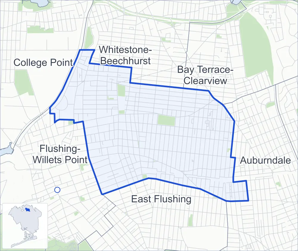
Murray Hill-Broadway Flushing borders six areas, and 33rd Avenue holds more of its corners than any other street, 34 of 396.
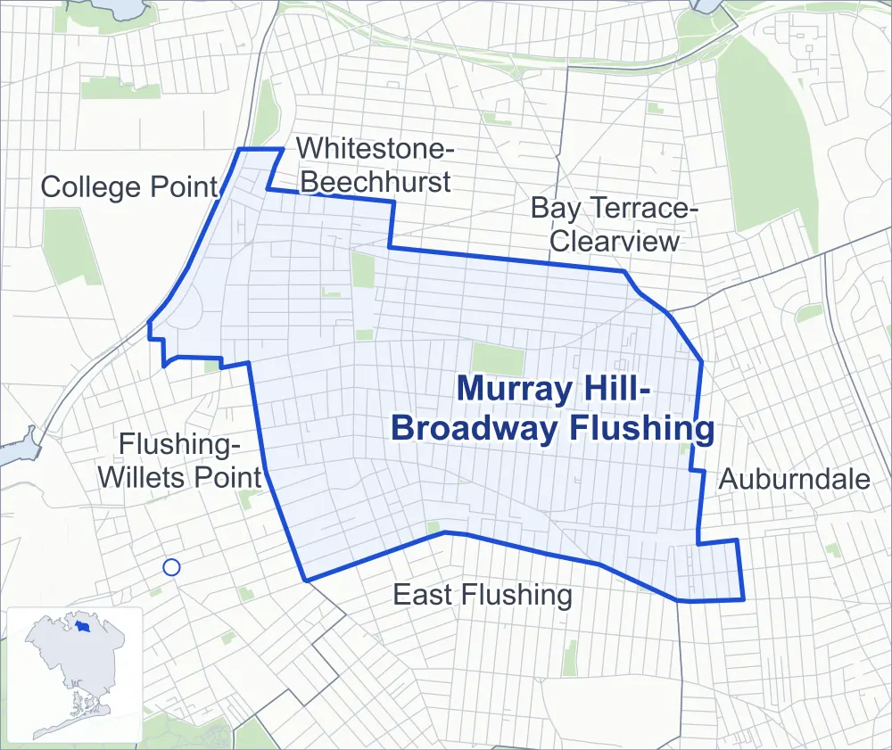
- Murray Hill-Broadway Flushing
- A neighboring area
- Park
- Another station
Neighborhood areas and streets: NYC Department of City Planning. Parks: NYC Parks. Stations: MTA.
Neighboring areas
- Whitestone-Beechhurst north
- Bay Terrace-Clearview northeast
- Auburndale east
- East Flushing south
- Flushing-Willets Point west
- College Point northwest
Getting around
Buses on 14 routes stop in or at the edge of Murray Hill-Broadway Flushing.
- 11 local bus routes
- 3 express bus routes
Local bus routes
- Q12
- Q13
- Q15
- Q16
- Q20
- Q28
- Q44-SBS
- Q50
- Q61
- Q65
- Q76
Express bus routes
- QM2
- QM20
- QM32
Safety record
Between 2021 and 2025, its corners averaged fewer police-reported crashes than the average Queens corner.
- 1,581 police-reported crashes at its corners
- 4.0 a corner, on average
- 5.2 the average Queens corner
- 68 corners with a clean record
Signal or safety changes on City record, at 50 of its corners
- Leading pedestrian intervals
- 37
- Accessible pedestrian signals
- 26
- Turn calming
- 8
- Safety Improvement Projects
- 7
- Enhanced crossings
- 3
- Barnes Dance all-way crossings
- 1
Camera tickets
In 2025 its corners had more school-zone speed camera tickets than red-light or bus-lane tickets.
- 0 red-light camera tickets
- 38,293 school-zone speed camera tickets at 19 corners
- 0 bus-lane camera tickets
- Most speed tickets
- Whitestone Expressway & 25th Road, 26,796
People and homes
The 2020 Census counted 57,387 residents in Murray Hill-Broadway Flushing, about 28,400 per square mile.
- 21,511 homes, 2020 Census
- 1,233 homes added since April 2010, net, by City Planning's count
Half of its 7,306 residential lots hold buildings from 1940 or earlier, and 42% of them date from before 1940, by the City's tax lot records.
Parks
- Parkland
- 22.5 acres of NYC Parks property
- The largest pieces
- Bowne Park (11.8 acres), Flushing Fields (7.7 acres) and Murray Hill Playground (1.2 acres)
Streets and trees
- Trees
- 7,686 in NYC Parks' records, most often London planetree, pin oak and Japanese flowering cherry
- Street with the most corners
- 33rd Avenue, with 34 of the area's 396
- Height above sea level
- From 9 feet at Whitestone Expressway & 137th Street to 116 feet at 33rd Avenue & 154th Street
- Honorary street names
- 12 at its corners, enacted by local law
Schools and libraries
The City lists 14 schools and one library in Murray Hill-Broadway Flushing.
- Public schools
- 6
- Charter and private schools
- 8
- Library
- McGoldrick Library
Public art
The City's public art inventory lists one work in Murray Hill-Broadway Flushing: Flushing World War Memorial (1935).
- 1 work of public art
Public safety
How complaints are countedIn 2025 the NYPD recorded 447 major felonies at places in Murray Hill-Broadway Flushing.
Recorded by the NYPD at places in Murray Hill-Broadway Flushing
- 405 major felonies in 2024
- 835 other felonies, misdemeanors and violations in 2025
In 2025, on the streets along the edge of Murray Hill-Broadway Flushing, the NYPD recorded another 78 major felonies. Counting the streets along its edge, in 2025 the NYPD recorded 9.1 major felonies for every thousand residents the 2020 Census counted in Murray Hill-Broadway Flushing.
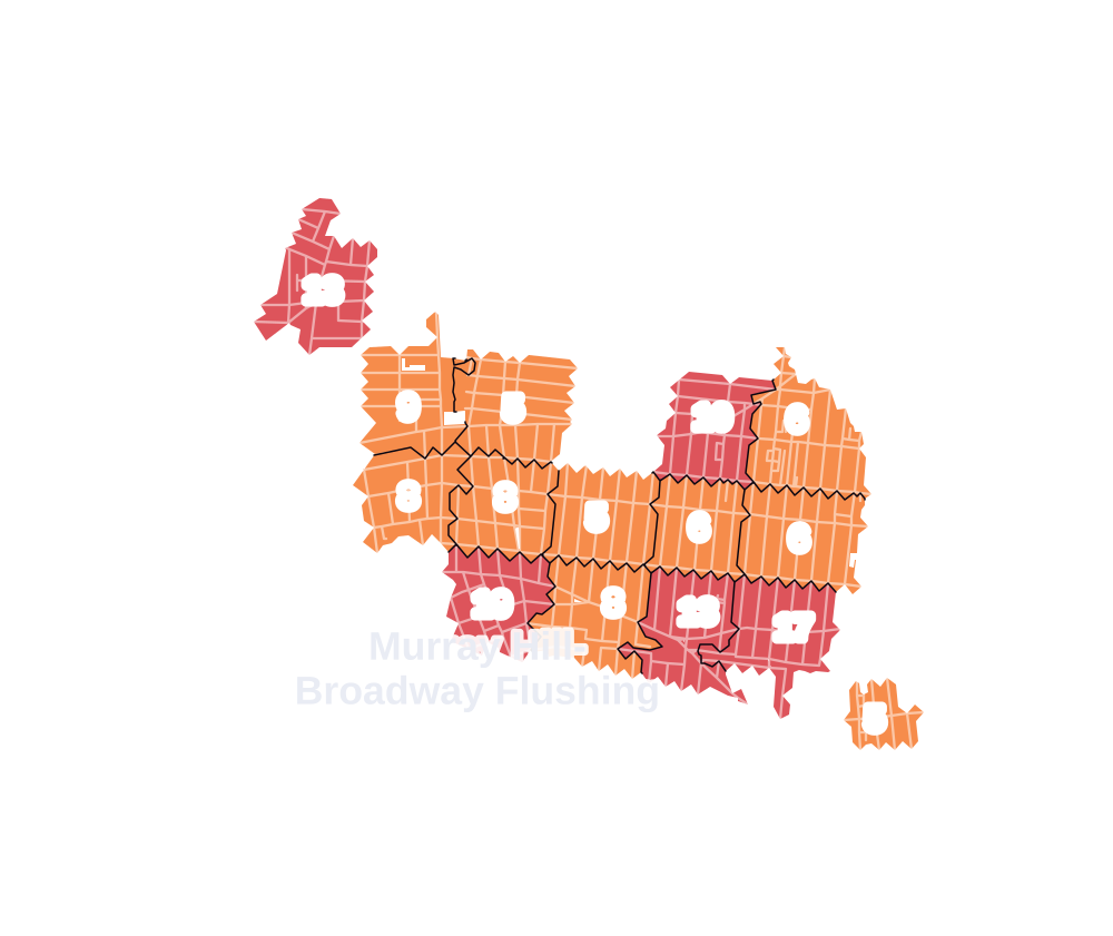
- 5 to 9
- 10 to 19
- 20 to 49
- 50 to 99
- 100 or more
- Not shaded: fewer than 5, held back under the rules in How complaints are counted, parks and public-housing grounds, and land in no patch
- Police precincts
- 109th (most of the area), 111th
From January to June 2026 the NYPD recorded 174 major felonies at places in Murray Hill-Broadway Flushing, against 214 in the same months of 2025.
Sources: the NYPD's Complaint Data Historic, updated April 28, 2026, and Complaint Data Current (Year To Date), updated July 27, 2026, on NYC Open Data. Figures to June 30, 2026.
Street corners
- 20th Avenue & 144th Street
- 21st Avenue & 144th Street
- 22nd Avenue & Lee Street
- 23rd Avenue & 146th Street
- 23rd Avenue & 147th Street
- 23rd Avenue & 149th Street
- 23rd Avenue & Lee Street
- 23rd Avenue & Ryan Street
- 24th Avenue & 146th Street
- 25th Avenue & 143rd Street
- 25th Avenue & 144th Street
- 25th Avenue & 154th Street
- 25th Avenue & 163rd Street
- 25th Avenue & Murray Street
- 25th Avenue & Willets Point Boulevard
- 25th Drive & Bayside Lane
- 25th Drive & Murray Lane
- 26th Avenue & 146th Street
- 26th Avenue & 154th Street
- 26th Avenue & 163rd Street
- 26th Avenue & Bayside Lane
- 26th Avenue & Murray Lane
- 26th Avenue & Murray Street
- 26th Avenue & Union Street
- 27th Avenue & 154th Street
- 27th Avenue & Bayside Lane
- 27th Avenue & Murray Lane
- 27th Avenue & Murray Street
- 28th Avenue & 141st Street
- 28th Avenue & 146th Street
- 28th Avenue & 154th Street
- 28th Avenue & 156th Street
- 28th Avenue & 158th Street
- 28th Avenue & 161st Street
- 28th Avenue & 163rd Street
- 28th Avenue & Murray Lane
- 28th Avenue & Murray Street
- 28th Avenue & Union Street
- 29th Avenue & 154th Street
- 29th Avenue & 156th Street
- 29th Avenue & 163rd Street
- 29th Avenue & 171st Street
- 29th Avenue & Bayside Lane
- 29th Avenue & Murray Lane
- 29th Avenue & Murray Street
- 29th Avenue & Union Street
- 32nd Avenue & 146th Street
- 32nd Avenue & 147th Place
- 32nd Avenue & 148th Street
- 32nd Avenue & 149th Street
- 32nd Avenue & 150th Place
- 32nd Avenue & 152nd Street
- 32nd Avenue & 153rd Street
- 32nd Avenue & 154th Street
- 32nd Avenue & 155th Street
- 32nd Avenue & 156th Street
- 32nd Avenue & 157th Street
- 32nd Avenue & 158th Street
- 32nd Avenue & 161st Street
- 32nd Avenue & 162nd Street
- 32nd Avenue & 163rd Street
- 32nd Avenue & 165th Street
- 32nd Avenue & 167th Street
- 32nd Avenue & 169th Street
- 32nd Avenue & 170th Street
- 32nd Avenue & 171st Street
- 32nd Avenue & Murray Lane
- 32nd Avenue & Murray Street
- 33rd Avenue & 145th Place
- 33rd Avenue & 145th Street
- 33rd Avenue & 146th Street
- 33rd Avenue & 147th Place
- 33rd Avenue & 149th Place
- 33rd Avenue & 150th Place
- 33rd Avenue & 152nd Street
- 33rd Avenue & 153rd Street
- 33rd Avenue & 154th Street
- 33rd Avenue & 156th Street
- 33rd Avenue & 158th Street
- 33rd Avenue & 163rd Street
- 33rd Avenue & 171st Street
- 33rd Avenue & Murray Lane
- 33rd Avenue & Murray Street
- 34th Avenue & 145th Place
- 34th Avenue & 145th Street
- 34th Avenue & 146th Street
- 34th Avenue & 147th Place
- 34th Avenue & 147th Street
- 34th Avenue & 148th Street
- 34th Avenue & 149th Place
- 34th Avenue & 149th Street
- 34th Avenue & 150th Place
- 34th Avenue & 153rd Street
- 34th Avenue & Murray Lane
- 34th Avenue & Murray Street
- 35th Avenue & 146th Street
- 35th Avenue & 147th Street
- 35th Avenue & 148th Street
- 35th Avenue & 149th Place
- 35th Avenue & 149th Street
- 35th Avenue & 150th Place
- 35th Avenue & 153rd Street
- 35th Avenue & 154th Street
- 35th Avenue & 155th Street
- 35th Avenue & 156th Street
- 35th Avenue & 157th Street
- 35th Avenue & 158th Street
- 35th Avenue & 159th Street
- 35th Avenue & 160th Street
- 35th Avenue & 161st Street
- 35th Avenue & 162nd Street
- 35th Avenue & 163rd Street
- 35th Avenue & 164th Street
- 35th Avenue & 165th Street
- 35th Avenue & 166th Street
- 35th Avenue & 167th Street
- 35th Avenue & 168th Street
- 35th Avenue & 169th Street
- 35th Avenue & 170th Street
- 35th Avenue & 171st Street
- 35th Avenue & 172nd Street
- 35th Avenue & Murray Lane
- 35th Avenue & Murray Street
- 35th Avenue & Parsons Boulevard
- 37th Avenue & 147th Street
- 38th Avenue & 149th Place
- 38th Avenue & 149th Street
- 39th Avenue & 170th Street
- 39th Avenue & 171st Street
- 39th Avenue & 172nd Street
- 39th Avenue & Utopia Parkway
- 41st Avenue & 147th Street
- 41st Avenue & 149th Place
- 41st Avenue & 149th Street
- 41st Avenue & 154th Street
- 41st Avenue & 155th Street
- 41st Avenue & 168th Street
- 41st Avenue & 169th Street
- 41st Avenue & 170th Street
- 41st Avenue & 171st Street
- 41st Avenue & Murray Street
- 42nd Avenue & 190th Street
- 42nd Avenue & Auburndale Lane
- 139th Street & 28th Road
- 139th Street & 31st Road
- 143rd Street & 22nd Road
- 143rd Street & 29th Road
- 143rd Street & Bayside Avenue
- 143rd Street & Union Street
- 144th Street & 21st Road
- 144th Street & 22nd Avenue
- 144th Street & 22nd Road
- 145th Street & 29th Road
- 146th Street & 22nd Avenue
- 146th Street & 25th Drive
- 146th Street & 25th Road
- 146th Street & 27th Avenue
- 146th Street & 29th Avenue
- 146th Street & 29th Road
- 146th Street & Bayside Avenue
- 146th Street & Willets Point Boulevard
- 147th Street & 22nd Avenue
- 147th Street & 24th Avenue
- 147th Street & 25th Drive
- 147th Street & 25th Road
- 147th Street & 26th Avenue
- 147th Street & 27th Avenue
- 147th Street & 28th Avenue
- 147th Street & 29th Avenue
- 147th Street & 33rd Avenue
- 147th Street & 38th Avenue
- 147th Street & Barclay Avenue
- 147th Street & Willets Point Boulevard
- 148th Street & 25th Drive
- 148th Street & 29th Avenue
- 148th Street & 33rd Avenue
- 148th Street & Bayside Avenue
- 148th Street & Willets Point Boulevard
- 149th Place & Barton Avenue
- 149th Street & 24th Avenue
- 149th Street & 24th Road
- 149th Street & 25th Avenue
- 149th Street & 25th Drive
- 149th Street & 26th Avenue
- 149th Street & 27th Avenue
- 149th Street & 28th Avenue
- 149th Street & 29th Avenue
- 149th Street & 33rd Avenue
- 149th Street & Barclay Avenue
- 149th Street & Bayside Avenue
- 149th Street & Sanford Avenue
- 150th Street & 22nd Avenue
- 150th Street & 23rd Avenue
- 150th Street & 24th Avenue
- 150th Street & 24th Road
- 150th Street & 25th Avenue
- 150th Street & 25th Drive
- 150th Street & 26th Avenue
- 150th Street & 27th Avenue
- 150th Street & 28th Avenue
- 150th Street & 29th Avenue
- 150th Street & 32nd Avenue
- 150th Street & 33rd Avenue
- 150th Street & 34th Avenue
- 150th Street & 35th Avenue
- 150th Street & 38th Avenue
- 150th Street & 41st Avenue
- 150th Street & Barclay Avenue
- 150th Street & Barton Avenue
- 150th Street & Bayside Avenue
- 150th Street & Roosevelt Avenue
- 150th Street & Sanford Avenue
- 150th Street & Willets Point Boulevard
- 153rd Street & 33rd Road
- 153rd Street & Bayside Avenue
- 154th Street & 24th Road
- 154th Street & 25th Drive
- 154th Street & Bayside Avenue
- 155th Street & 29th Avenue
- 155th Street & 33rd Avenue
- 155th Street & Sanford Avenue
- 156th Street & Barclay Avenue
- 157th Street & 24th Road
- 157th Street & 25th Avenue
- 157th Street & 25th Drive
- 157th Street & 26th Avenue
- 157th Street & 27th Avenue
- 157th Street & 28th Avenue
- 157th Street & 29th Avenue
- 157th Street & 33rd Avenue
- 157th Street & Depot Road
- 157th Street & Sanford Avenue
- 158th Street & 29th Avenue
- 158th Street & Depot Road
- 158th Street & Station Road
- 159th Street & 28th Avenue
- 159th Street & 29th Avenue
- 159th Street & 32nd Avenue
- 159th Street & 33rd Avenue
- 159th Street & Depot Road
- 159th Street & Station Road
- 160th Street & 24th Road
- 160th Street & 25th Avenue
- 160th Street & 25th Drive
- 160th Street & 26th Avenue
- 160th Street & 27th Avenue
- 160th Street & 28th Avenue
- 160th Street & 29th Avenue
- 160th Street & 32nd Avenue
- 160th Street & 33rd Avenue
- 160th Street & Station Road
- 161st Street & 29th Avenue
- 161st Street & 33rd Avenue
- 161st Street & Sanford Avenue
- 161st Street & Station Road
- 162nd Street & 29th Avenue
- 162nd Street & 33rd Avenue
- 162nd Street & Crocheron Avenue
- 162nd Street & Sanford Avenue
- 162nd Street & Station Road
- 163rd Street & 25th Drive
- 163rd Street & 27th Avenue
- 163rd Street & Crocheron Avenue
- 163rd Street & Sanford Avenue
- 164th Street & 27th Avenue
- 164th Street & 29th Avenue
- 164th Street & 32nd Avenue
- 164th Street & 33rd Avenue
- 164th Street & Bayside Lane
- 164th Street & Crocheron Avenue
- 164th Street & Depot Road
- 164th Street & Station Road
- 165th Street & 27th Avenue
- 165th Street & 29th Avenue
- 165th Street & 33rd Avenue
- 165th Street & Bayside Lane
- 165th Street & Crocheron Avenue
- 165th Street & Depot Road
- 165th Street & Station Road
- 166th Street & 25th Avenue
- 166th Street & 25th Drive
- 166th Street & 26th Avenue
- 166th Street & 27th Avenue
- 166th Street & 29th Avenue
- 166th Street & 32nd Avenue
- 166th Street & 33rd Avenue
- 166th Street & Bayside Lane
- 166th Street & Crocheron Avenue
- 166th Street & Depot Road
- 166th Street & Station Road
- 167th Street & 27th Avenue
- 167th Street & 29th Avenue
- 167th Street & 33rd Avenue
- 167th Street & Crocheron Avenue
- 167th Street & Depot Road
- 167th Street & Station Road
- 168th Street & 26th Avenue
- 168th Street & 27th Avenue
- 168th Street & 29th Avenue
- 168th Street & 32nd Avenue
- 168th Street & 33rd Avenue
- 168th Street & Crocheron Avenue
- 168th Street & Depot Road
- 169th Street & 29th Avenue
- 169th Street & 33rd Avenue
- 169th Street & Crocheron Avenue
- 169th Street & Depot Road
- 170th Street & 29th Avenue
- 170th Street & 33rd Avenue
- 170th Street & Crocheron Avenue
- 171st Street & Crocheron Avenue
- 172nd Street & 33rd Avenue
- 172nd Street & 42nd Avenue
- 172nd Street & Crocheron Avenue
- 172nd Street & Station Road
- 189th Street & 42nd Avenue
- 189th Street & Station Road
- Barclay Avenue & 149th Place
- Bayside Avenue & 150th Place
- Bayside Avenue & 152nd Street
- Bayside Avenue & Murray Lane
- Murray Street & 25th Drive
- Murray Street & 33rd Road
- Murray Street & Barclay Avenue
- Murray Street & Bayside Avenue
- Northern Boulevard & 146th Street
- Northern Boulevard & 147th Street
- Northern Boulevard & 149th Place
- Northern Boulevard & 149th Street
- Northern Boulevard & 150th Place
- Northern Boulevard & 150th Street
- Northern Boulevard & 153rd Street
- Northern Boulevard & 154th Street
- Northern Boulevard & 155th Street
- Northern Boulevard & 157th Street
- Northern Boulevard & 158th Street
- Northern Boulevard & 159th Street
- Northern Boulevard & 160th Street
- Northern Boulevard & 161st Street
- Northern Boulevard & 162nd Street
- Northern Boulevard & 163rd Street
- Northern Boulevard & 164th Street
- Northern Boulevard & 165th Street
- Northern Boulevard & 166th Street
- Northern Boulevard & 167th Street
- Northern Boulevard & 171st Street
- Northern Boulevard & 189th Street
- Northern Boulevard & 191st Street
- Northern Boulevard & Crocheron Avenue
- Northern Boulevard & Depot Road
- Northern Boulevard & Murray Street
- Northern Boulevard & Roosevelt Avenue
- Parsons Boulevard & 21st Avenue
- Parsons Boulevard & 22nd Avenue
- Parsons Boulevard & 22nd Road
- Parsons Boulevard & 23rd Avenue
- Parsons Boulevard & 24th Avenue
- Parsons Boulevard & 25th Avenue
- Parsons Boulevard & 25th Drive
- Parsons Boulevard & 26th Avenue
- Parsons Boulevard & 27th Avenue
- Parsons Boulevard & 28th Avenue
- Parsons Boulevard & 29th Avenue
- Parsons Boulevard & 29th Road
- Parsons Boulevard & 32nd Avenue
- Parsons Boulevard & 33rd Avenue
- Parsons Boulevard & 37th Avenue
- Parsons Boulevard & 38th Avenue
- Parsons Boulevard & 41st Avenue
- Parsons Boulevard & Bayside Avenue
- Parsons Boulevard & Roosevelt Avenue
- Roosevelt Avenue & 147th Street
- Roosevelt Avenue & 149th Place
- Roosevelt Avenue & 149th Street
- Roosevelt Avenue & 150th Place
- Roosevelt Avenue & 154th Street
- Roosevelt Avenue & 155th Street
- Roosevelt Avenue & Murray Street
- Sanford Avenue & Murray Street
- Union Street & 29th Road
- Union Street & 31st Road
- Utopia Parkway & 42nd Avenue
- Utopia Parkway & Crocheron Avenue
- Utopia Parkway & Station Road
- Whitestone Expressway & 21st Avenue
- Whitestone Expressway & 21st Road
- Whitestone Expressway & 22nd Avenue
- Whitestone Expressway & 22nd Road
- Whitestone Expressway & 25th Avenue
- Whitestone Expressway & 25th Road
- Whitestone Expressway & 28th Road
- Whitestone Expressway & 137th Street
- Whitestone Expressway & 141st Street
- Willets Point Boulevard & 24th Road
- Willets Point Boulevard & 144th Place
- Willets Point Boulevard & 144th Street
How the figures above are measured: Methodology.