Flushing-Willets Point
Neighborhood · Queens
Flushing-Willets Point spans the Flushing River, pairing downtown Flushing on its eastern shore with the Willets Point district on its western shore, between Northern Boulevard and Roosevelt Avenue.
- 1.38 square miles
- 69,879 residents, 2020 Census
- 227 street corners
- 1 subway station
- 24 bus routes
Founded in 1645 under a Dutch West India Company charter as Vlissingen, Flushing is where residents approved the Flushing Remonstrance of 1657, a petition making the case for religious freedom, and Bowne House on Bowne Street, built about 1661, is where John Bowne held Quaker meetings. Flushing Town Hall, begun in 1862, was restored over nine years from 1990 and is now an arts center. Main Street and Roosevelt Avenue anchor Flushing's Chinatown, one of the largest in the world.
Sources: Flushing, Queens (Wikipedia); Willets Point (Wikipedia); Mission, Vision & Organizational History (Flushing Town Hall); Welcome to Bowne House (Bowne House Historical Society).
Flushing-Willets Point borders five areas, and College Point Boulevard holds more of its corners than any other street, 24 of 227.
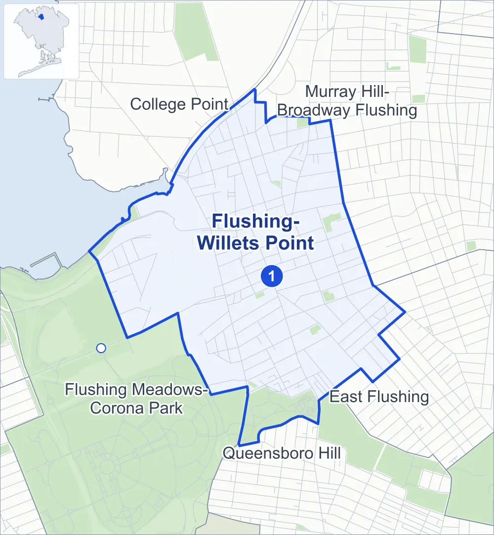
- Flushing-Willets Point
- A neighboring area
- Park
- A station in the list
- Another station
Neighborhood areas and streets: NYC Department of City Planning. Parks: NYC Parks. Stations: MTA.
Neighboring areas
- College Point north
- Murray Hill-Broadway Flushing northeast
- East Flushing southeast
- Queensboro Hill south
- Flushing Meadows-Corona Park southwest
Subway stations
- Flushing-Main St lines 7 accessible
Getting around
One subway station and buses on 24 routes stop in or at the edge of Flushing-Willets Point.
- 1 subway station
- 1 listed by the MTA as fully accessible
- 21 local bus routes
- 3 express bus routes
Local bus routes
- Q12
- Q13
- Q15
- Q16
- Q17
- Q19
- Q20
- Q25
- Q26
- Q27
- Q28
- Q44-SBS
- Q50
- Q58
- Q61
- Q63
- Q65
- Q66
- Q90
- Q98
- T321
Express bus routes
- QM2
- QM20
- QM32
Safety record
Between 2021 and 2025, its corners averaged more police-reported crashes than the average Queens corner.
- 2,884 police-reported crashes at its corners
- 12.7 a corner, on average
- 5.2 the average Queens corner
- 32 corners with a clean record
Signal or safety changes on City record, at 69 of its corners
- Leading pedestrian intervals
- 39
- Turn calming
- 38
- Accessible pedestrian signals
- 32
- Barnes Dance all-way crossings
- 11
- Safety Improvement Projects
- 6
Camera tickets
In 2025 its corners had more bus-lane camera tickets than school-zone speed or red-light tickets.
- 395 red-light camera tickets at one corner
- 11,083 school-zone speed camera tickets at seven corners
- 30,384 bus-lane camera tickets at six corners
- Most red-light tickets
- Roosevelt Avenue & College Point Boulevard, 395
- Most speed tickets
- Whitestone Expressway & Farrington Street, 6,769
- Most bus-lane tickets
- 37th Avenue & Main Street, 17,035
People and homes
The 2020 Census counted 69,879 residents in Flushing-Willets Point, about 50,600 per square mile.
- 28,551 homes, 2020 Census
- 5,174 homes added since April 2010, net, by City Planning's count
Half of its 1,543 residential lots hold buildings from 1970 or earlier, and 21% of them date from before 1940, by the City's tax lot records.
NYCHA developments
NYCHA's Bland and Latimer Gardens developments lie wholly or partly within Flushing-Willets Point, as does one more that NYCHA names by a building's address.
Parks and landmarks
- Parkland
- 49.6 acres of NYC Parks property
- The largest pieces
- Kissena Corridor Park (34.5 acres), Flushing Meadows Corona Park (7.1 acres) and Margaret I. Carman Green - Weeping Beech (2.6 acres)
- Designated landmarks
- Saint George's Church (Old Parish House), Saint George's Church, the Friends Meeting House and the Flushing Town Hall, among others
Streets and trees
- Trees
- 2,861 in NYC Parks' records, most often pin oak, thornless honeylocust and London planetree
- Street with the most corners
- College Point Boulevard, with 24 of the area's 227
- Height above sea level
- From 6 feet at 40th Road & Delong Street to 78 feet at Parsons Boulevard & Sanford Avenue
- Honorary street names
- 4 at its corners, enacted by local law
Schools and libraries
The City lists nine schools and two libraries in Flushing-Willets Point.
- Public schools
- 7
- Charter and private schools
- 2
- Libraries
- Flushing Library and Mitchell-Linden Library
Public art
The City's public art inventory lists three works in Flushing-Willets Point: Flushing Park Memorial (1865), Flushing Memorial (1925) and Goldenrain Corners (about 2004).
- 3 works of public art
Public safety
How complaints are countedIn 2025 the NYPD recorded 929 major felonies at places in Flushing-Willets Point.
Recorded by the NYPD at places in Flushing-Willets Point
- 1,205 major felonies in 2024 276 fewer in 2025
- 3,274 other felonies, misdemeanors and violations in 2025
In 2025, on the streets along the edge of Flushing-Willets Point, the NYPD recorded another 73 major felonies. Counting the streets along its edge, in 2025 the NYPD recorded 14.3 major felonies for every thousand residents the 2020 Census counted in Flushing-Willets Point.
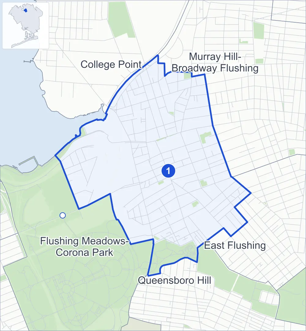
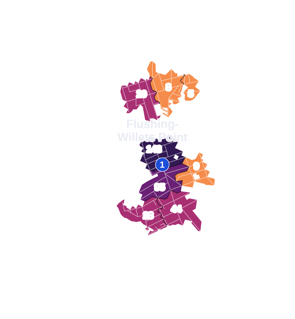
- 5 to 9
- 10 to 19
- 20 to 49
- 50 to 99
- 100 or more
- Not shaded: fewer than 5, held back under the rules in How complaints are counted, parks and public-housing grounds, and land in no patch
- Police precincts
- 109th (most of the area), 110th
From January to June 2026 the NYPD recorded 406 major felonies at places in Flushing-Willets Point, against 453 in the same months of 2025.
Sources: the NYPD's Complaint Data Historic, updated April 28, 2026, and Complaint Data Current (Year To Date), updated July 27, 2026, on NYC Open Data. Figures to June 30, 2026.
Street corners
- 31st Drive & Farrington Street
- 31st Road & Downing Street
- 31st Road & Farrington Street
- 31st Road & Linden Place
- 31st Road & Stratton Street
- 31st Road & Ulmer Street
- 32nd Avenue & 137th Street
- 32nd Avenue & 138th Street
- 32nd Avenue & 140th Street
- 32nd Avenue & 143rd Street
- 32nd Avenue & Downing Street
- 32nd Avenue & Farrington Street
- 32nd Avenue & Higgins Street
- 32nd Avenue & Leavitt Street
- 32nd Avenue & Linden Place
- 32nd Avenue & Miller Street
- 32nd Avenue & Union Street
- 33rd Avenue & 143rd Street
- 33rd Avenue & Downing Street
- 33rd Avenue & Farrington Street
- 33rd Avenue & Leavitt Street
- 33rd Avenue & Prince Street
- 33rd Avenue & Union Street
- 34th Avenue & 126th Place
- 34th Avenue & 127th Place
- 34th Avenue & 127th Street
- 34th Avenue & College Point Boulevard
- 34th Avenue & Collins Place
- 34th Avenue & Leavitt Street
- 34th Avenue & Shea Road
- 34th Avenue & Union Street
- 34th Avenue & Willets Point Boulevard
- 34th Road & Leavitt Street
- 35th Avenue & 127th Street
- 35th Avenue & College Point Boulevard
- 35th Avenue & Collins Place
- 35th Avenue & Farrington Street
- 35th Avenue & Leavitt Street
- 35th Avenue & Linden Place
- 35th Avenue & Prince Street
- 35th Avenue & Seaver Way
- 35th Avenue & Union Street
- 36th Avenue & Bud Place
- 36th Avenue & King Road
- 36th Avenue & Prince Street
- 36th Avenue & Seaver Way
- 36th Road & Bud Place
- 37th Avenue & 138th Street
- 37th Avenue & Bowne Street
- 37th Avenue & Main Street
- 37th Avenue & Prince Street
- 37th Avenue & Union Street
- 38th Avenue & 126th Lane
- 38th Avenue & 138th Street
- 38th Avenue & Bowne Street
- 38th Avenue & Prince Street
- 38th Avenue & Seaver Way
- 38th Avenue & Union Street
- 39th Avenue & 126th Lane
- 39th Avenue & 138th Street
- 39th Avenue & Janet Place
- 39th Avenue & Lippmann Plaza
- 39th Avenue & Main Street
- 39th Avenue & Prince Street
- 39th Avenue & Union Street
- 40th Road & Delong Street
- 40th Road & Prince Street
- 41st Avenue & Bowne Street
- 41st Avenue & College Point Boulevard
- 41st Avenue & Delong Street
- 41st Avenue & Fuller Place
- 41st Avenue & Haight Street
- 41st Avenue & Main Street
- 41st Avenue & Main Street at Kissena Boulevard
- 41st Avenue & Union Street
- 41st Road & Frame Place
- 127th Street & Willets Point Boulevard
- 131st Street & East Road
- 131st Street & Fowler Avenue
- 135th Street & Elder Avenue
- 137th Street & 29th Road
- 137th Street & 31st Road
- 137th Street & Latimer Place
- 137th Street & Leavitt Street
- 138th Street & 31st Drive
- 138th Street & 31st Road
- 138th Street & Peck Avenue
- 140th Street & 31st Drive
- 140th Street & 31st Road
- Ash Avenue & Magnolia Place
- Ash Avenue & Syringa Place
- Avery Avenue & Saull Street
- Barclay Avenue & Bowne Street
- Beech Avenue & Magnolia Place
- Beech Avenue & Phlox Place
- Beech Avenue & Syringa Place
- Blossom Avenue & Crommelin Street
- Blossom Avenue & Saull Street
- Bowne Street & Ash Avenue
- Bowne Street & Beech Avenue
- Bowne Street & Franklin Avenue
- Cherry Avenue & Byrd Street
- Cherry Avenue & Colden Street
- Cherry Avenue & Crommelin Street
- Cherry Avenue & Phlox Place
- Cherry Avenue & Robinson Street
- Cherry Avenue & Saull Street
- Cherry Circle Path & Circle Garden Path
- Colden Street & Elder Avenue
- Colden Street & Franklin Avenue
- College Point Boulevard & 32nd Avenue
- College Point Boulevard & 33rd Avenue
- College Point Boulevard & 36th Avenue
- College Point Boulevard & 36th Road
- College Point Boulevard & 37th Avenue
- College Point Boulevard & 39th Avenue
- College Point Boulevard & 40th Road
- College Point Boulevard & 41st Road
- College Point Boulevard & Avery Avenue
- College Point Boulevard & Blossom Avenue
- College Point Boulevard & Booth Memorial Avenue
- College Point Boulevard & Botanical Garden Bridge
- College Point Boulevard & Fowler Avenue
- College Point Boulevard & King Road
- College Point Boulevard & Maple Avenue
- College Point Boulevard & Pople Avenue
- College Point Boulevard & Sanford Avenue
- Crommelin Street & Dahlia Avenue
- Franklin Avenue & Saull Street
- Grand Central Parkway & Seaver Way
- Kissena Boulevard & Ash Avenue
- Kissena Boulevard & Barclay Avenue
- Kissena Boulevard & Beech Avenue
- Kissena Boulevard & Cherry Avenue
- Kissena Boulevard & Elder Avenue
- Kissena Boulevard & Franklin Avenue
- Kissena Boulevard & Maple Avenue
- Kissena Boulevard & Sanford Avenue
- Leavitt Street & Carlton Place
- Linden Place & Carlton Place
- Linden Place & Latimer Place
- Main Street & 38th Avenue
- Main Street & 40th Road
- Main Street & 41st Road
- Main Street & Blossom Avenue
- Main Street & Cherry Avenue
- Main Street & Dahlia Avenue
- Main Street & Franklin Avenue
- Main Street & Maple Avenue
- Main Street & Sanford Avenue
- Maple Avenue & Frame Place
- Maple Avenue & Fuller Place
- Maple Avenue & Haight Street
- Maple Avenue & Saull Street
- Marina Road & Grand Central Parkway
- Marina Road & Northern Boulevard at Harper Street
- Meadow Oval Path & Botanical Garden Driveway
- Northern Boulevard & Bowne Street
- Northern Boulevard & College Point Boulevard
- Northern Boulevard & Linden Place
- Northern Boulevard & Main Street
- Northern Boulevard & Marina Road
- Northern Boulevard & Parsons Boulevard
- Northern Boulevard & Prince Street
- Northern Boulevard & Union Street
- Northern Boulevard & Van Wyck Expressway (Astoria Boulevard)
- Northern Boulevard & Van Wyck Expressway (Whitestone Expressway)
- Northern Boulevard & Van Wyck Expressway at 127th Place
- Northern Boulevard & Whitestone Expressway
- Northern Boulevard & Whitestone Expressway at 127th Street
- Northern Boulevard & Whitestone Expressway at Van Wyck Expressway
- Northern Boulevard & Whitestone Expressway at Van Wyck Expressway (Exit 9)
- Northern Boulevard & Whitestone Expressway at Van Wyck Expressway (Exit 9E)
- Northern Boulevard & Whitestone Expressway at Van Wyck Expressway (Exit 13)
- Northern Boulevard & Willets Point Boulevard
- Oak Allee Promenade & Botanical Garden Entrance
- Oak Allee Promenade & Cherry Circle Path
- Parsons Boulevard & 34th Avenue
- Parsons Boulevard & Barclay Avenue
- Parsons Boulevard & Beech Avenue
- Parsons Boulevard & Sanford Avenue
- Prince Street & 36th Road
- Prince Street & Linneaus Place
- Queens Botanical Garden Path & Botanical Garden Bridge
- Queens Botanical Garden Path & Magnolia Walk
- Roosevelt Avenue & 126th Street
- Roosevelt Avenue & Bowne Street
- Roosevelt Avenue & College Point Boulevard
- Roosevelt Avenue & Janet Place
- Roosevelt Avenue & Lippmann Plaza
- Roosevelt Avenue & Main Street
- Roosevelt Avenue & Prince Street
- Roosevelt Avenue & Union Street
- Sanford Avenue & Bowne Street
- Sanford Avenue & Frame Place
- Sanford Avenue & Fuller Place
- Sanford Avenue & Haight Street
- Sanford Avenue & Maple Avenue
- Sanford Avenue & Summit Court
- Saull Street & Crommelin Street
- Saull Street & Pople Avenue
- Union Street & 31st Drive
- Union Street & 34th Road
- Union Street & Barclay Avenue
- Union Street & Bayside Avenue
- Union Street & Cherry Avenue
- Union Street & Franklin Avenue
- Union Street & Sanford Avenue
- Van Wyck Expressway & East Road
- Van Wyck Expressway & Marina Road
- Van Wyck Expressway & Northern Boulevard
- Van Wyck Expressway & Roosevelt Avenue Bridge
- Van Wyck Expressway & Whitestone Expressway
- Van Wyck Expressway & Whitestone Expressway (Exit 14, north-east)
- Van Wyck Expressway & Whitestone Expressway (Exit 14, south-west)
- Whitestone Expressway & 29th Road
- Whitestone Expressway & College Point Boulevard
- Whitestone Expressway & College Point Boulevard at 32nd Avenue
- Whitestone Expressway & Downing Street
- Whitestone Expressway & Farrington Street
- Whitestone Expressway & Grand Central Parkway
- Whitestone Expressway & Higgins Street
- Whitestone Expressway & Ulmer Street
- Whitestone Expressway & Whitestone Expressway Turnaround
- Whitestone Expressway & Whitestone Expressway Turnaround at Stratton Street
- Willets Point Boulevard & Marina Road
- Willets Point Boulevard & Van Wyck Expressway
How the figures above are measured: Methodology.