East Flushing
Neighborhood · Queens
East Flushing, part of greater Flushing in north-central Queens, lies east of Kissena Boulevard and reaches south to Kissena Park.
- 1.14 square miles
- 34,704 residents, 2020 Census
- 208 street corners
- 7 bus routes
Many of its avenues run alphabetically by plant name, from Ash Avenue to Rose Avenue, a legacy of the Prince nursery and its rivals, which made Flushing home to North America's first commercial tree nurseries. Flushing Cemetery, chartered in 1853, is the resting place of musicians Louis Armstrong, Dizzy Gillespie and Johnny Hodges. On Bowne Street, the Hindu Temple Society of North America's South Indian-style temple, consecrated in 1977, was one of the first Hindu temples built in North America.
Sources: Flushing from A-R. Avenues with plant names in Queens (Forgotten New York); Flushing, Queens (Wikipedia); Flushing Cemetery (Wikipedia); Hindu Temple Society of North America (City Lore).
East Flushing borders five areas, and 45th Avenue holds more of its corners than any other street, 27 of 208.
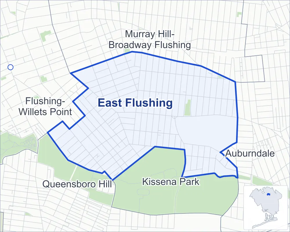
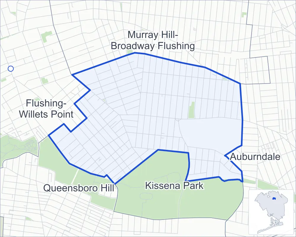
- East Flushing
- A neighboring area
- Park
- Another station
Neighborhood areas and streets: NYC Department of City Planning. Parks: NYC Parks. Stations: MTA.
Neighboring areas
- Murray Hill-Broadway Flushing north
- Auburndale east
- Kissena Park southeast
- Queensboro Hill southwest
- Flushing-Willets Point west
Getting around
Buses on seven routes stop in or at the edge of East Flushing.
- 7 local bus routes
Local bus routes
- Q12
- Q13
- Q17
- Q25
- Q26
- Q27
- Q65
Safety record
Between 2021 and 2025, its corners averaged fewer police-reported crashes than the average Queens corner.
- 838 police-reported crashes at its corners
- 4.0 a corner, on average
- 5.2 the average Queens corner
- 28 corners with a clean record
Signal or safety changes on City record, at 15 of its corners
- Leading pedestrian intervals
- 12
- Accessible pedestrian signals
- 10
- Turn calming
- 4
- Barnes Dance all-way crossings
- 1
Camera tickets
In 2025 its corners had more school-zone speed camera tickets than red-light or bus-lane tickets.
- 0 red-light camera tickets
- 15,610 school-zone speed camera tickets at four corners
- 0 bus-lane camera tickets
- Most speed tickets
- Northern Boulevard & 170th Street, 6,813
People and homes
The 2020 Census counted 34,704 residents in East Flushing, about 30,400 per square mile.
- 12,089 homes, 2020 Census
- 669 homes added since April 2010, net, by City Planning's count
Half of its 4,681 residential lots hold buildings from 1935 or earlier, and 50% of them date from before 1940, by the City's tax lot records.
Parks
- Parkland
- 4.4 acres of NYC Parks property
- The largest pieces
- The Olde Towne of Flushing Burial Ground (3.1 acres), Kissena Park (0.9 acre) and Plaut Triangle (0.3 acre)
Streets and trees
- Trees
- 3,970 in NYC Parks' records, most often pin oak, London planetree and Japanese flowering cherry
- Street with the most corners
- 45th Avenue, with 27 of the area's 208
- Height above sea level
- From 13 feet at Robinson Street & Rose Avenue to 92 feet at 149th Street & Ash Avenue
- Honorary street names
- 3 at its corners, enacted by local law
Schools
The City lists six schools in East Flushing.
- Public schools
- 5
- Charter or private school
- 1
Public safety
How complaints are countedIn 2025 the NYPD recorded 202 major felonies at places in East Flushing.
Recorded by the NYPD at places in East Flushing
- 216 major felonies in 2024
- 439 other felonies, misdemeanors and violations in 2025
In 2025, on the streets along the edge of East Flushing, the NYPD recorded another 74 major felonies. Counting the streets along its edge, in 2025 the NYPD recorded 8.0 major felonies for every thousand residents the 2020 Census counted in East Flushing.
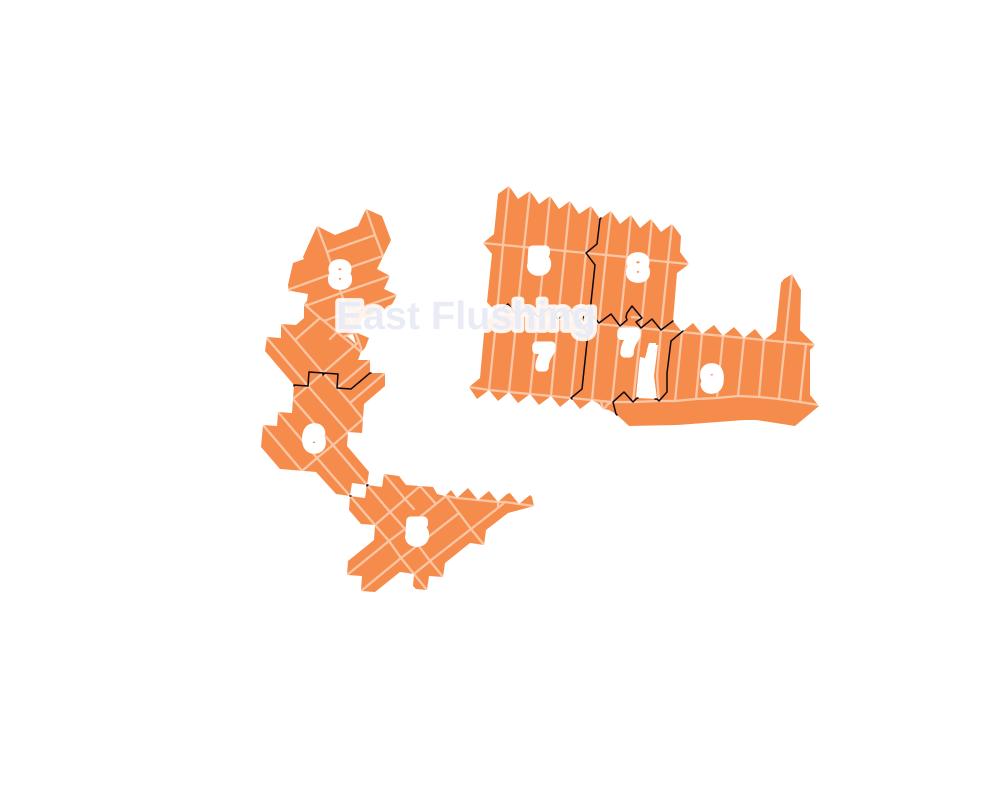
- 5 to 9
- 10 to 19
- 20 to 49
- 50 to 99
- 100 or more
- Not shaded: fewer than 5, held back under the rules in How complaints are counted, parks and public-housing grounds, and land in no patch
- Police precinct
- 109th
From January to June 2026 the NYPD recorded 84 major felonies at places in East Flushing, against 92 in the same months of 2025.
Sources: the NYPD's Complaint Data Historic, updated April 28, 2026, and Complaint Data Current (Year To Date), updated July 27, 2026, on NYC Open Data. Figures to June 30, 2026.
Street corners
- 43rd Avenue & 156th Street
- 43rd Avenue & 157th Street
- 43rd Avenue & 158th Street
- 43rd Avenue & 159th Street
- 43rd Avenue & 160th Street
- 43rd Avenue & 161st Street
- 43rd Avenue & 162nd Street
- 43rd Avenue & 163rd Street
- 43rd Avenue & 164th Street
- 43rd Avenue & 165th Street
- 43rd Avenue & 166th Street
- 43rd Avenue & 167th Street
- 43rd Avenue & 168th Street
- 43rd Avenue & 169th Street
- 43rd Avenue & 170th Street
- 45th Avenue & 149th Street
- 45th Avenue & 156th Street
- 45th Avenue & 158th Street
- 45th Avenue & 161st Street
- 45th Avenue & 162nd Street
- 45th Avenue & 163rd Street
- 45th Avenue & 165th Street
- 45th Avenue & 167th Street
- 45th Avenue & 171st Place
- 45th Avenue & 171st Street
- 45th Avenue & Auburndale Lane
- 45th Avenue & Bowne Street
- 45th Avenue & Burling Street
- 45th Avenue & Kissena Boulevard
- 45th Avenue & Murray Street
- 45th Avenue & Robinson Street
- 45th Avenue & Smart Street
- 45th Avenue & Union Street
- 46th Avenue & 156th Street
- 46th Avenue & 158th Street
- 46th Avenue & 161st Street
- 46th Avenue & 162nd Street
- 46th Avenue & 163rd Street
- 46th Avenue & 171st Place
- 46th Avenue & 171st Street
- 46th Avenue & Pidgeon Meadow Road
- 147th Street & Ash Avenue
- 147th Street & Beech Avenue
- 147th Street & Cherry Avenue
- 147th Street & Delaware Avenue
- 147th Street & Elm Avenue
- 147th Street & Sanford Avenue
- 149th Place & Ash Avenue
- 149th Street & 46th Avenue
- 149th Street & Ash Avenue
- 149th Street & Beech Avenue
- 149th Street & Cherry Avenue
- 149th Street & Delaware Avenue
- 149th Street & Elm Avenue
- 149th Street & Hawthorn Avenue
- 149th Street & Hollywood Avenue
- 155th Street & Beech Avenue
- 156th Street & Beech Avenue
- 156th Street & Delaware Avenue
- 156th Street & Elm Avenue
- 156th Street & Hawthorn Avenue
- 156th Street & Hollywood Avenue
- 156th Street & Jasmine Avenue
- 156th Street & Kalmia Avenue
- 156th Street & Laburnum Avenue
- 156th Street & Murray Street
- 156th Street & Oak Avenue
- 156th Street & Sanford Avenue
- 157th Street & 45th Avenue
- 157th Street & 46th Avenue
- 157th Street & Laburnum Avenue
- 157th Street & Oak Avenue
- 158th Street & Laburnum Avenue
- 158th Street & Oak Avenue
- 158th Street & Quince Avenue
- 158th Street & Sanford Avenue
- 159th Street & 45th Avenue
- 159th Street & 46th Avenue
- 159th Street & Laburnum Avenue
- 159th Street & Oak Avenue
- 159th Street & Sanford Avenue
- 160th Street & 45th Avenue
- 160th Street & 46th Avenue
- 160th Street & Laburnum Avenue
- 160th Street & Oak Avenue
- 160th Street & Sanford Avenue
- 161st Street & Laburnum Avenue
- 161st Street & Oak Avenue
- 162nd Street & Laburnum Avenue
- 162nd Street & Oak Avenue
- 163rd Street & Laburnum Avenue
- 163rd Street & Oak Avenue
- 164th Street & 45th Avenue
- 164th Street & 46th Avenue
- 164th Street & Metcalf Avenue
- 164th Street & Oak Avenue
- 164th Street & Pidgeon Meadow Road
- 164th Street & Sanford Avenue
- 164th Street & Underhill Avenue
- 165th Street & 46th Avenue
- 165th Street & Sanford Avenue
- 166th Street & 45th Avenue
- 166th Street & 46th Avenue
- 166th Street & Lithonia Avenue
- 166th Street & Metcalf Avenue
- 166th Street & Pidgeon Meadow Road
- 167th Street & 46th Avenue
- 167th Street & Lithonia Avenue
- 167th Street & Metcalf Avenue
- 167th Street & Pidgeon Meadow Road
- 168th Street & 45th Avenue
- 168th Street & 46th Avenue
- 168th Street & Lithonia Avenue
- 168th Street & Metcalf Avenue
- 168th Street & Pidgeon Meadow Road
- 168th Street & Underhill Avenue
- 169th Street & 45th Avenue
- 169th Street & 46th Avenue
- 169th Street & Lithonia Avenue
- 169th Street & Pidgeon Meadow Road
- 169th Street & Underhill Avenue
- 170th Street & 45th Avenue
- 170th Street & 46th Avenue
- 170th Street & Lithonia Avenue
- 171st Street & Underhill Avenue
- Auburndale Lane & Effington Avenue
- Auburndale Lane & Gladwin Avenue
- Beech Avenue & 149th Place
- Bowne Street & Cherry Avenue
- Bowne Street & Holly Avenue
- Bowne Street & Laburnum Avenue
- Bowne Street & Negundo Avenue
- Bowne Street & Oak Avenue
- Bowne Street & Poplar Avenue
- Bowne Street & Quince Avenue
- Bowne Street & Rose Avenue
- Burling Street & Delaware Avenue
- Burling Street & Georgia Road
- Burling Street & Hawthorn Avenue
- Burling Street & Jasmine Avenue
- Burling Street & Kalmia Avenue
- Burling Street & Negundo Avenue
- Cherry Avenue & Burling Street
- Cherry Avenue & Smart Street
- Colden Street & Juniper Avenue
- Colden Street & Laburnum Avenue
- Colden Street & Negundo Avenue
- Fresh Meadow Lane & Underhill Avenue
- Holly Avenue & Burling Street
- Holly Avenue & Robinson Street
- Holly Avenue & Smart Street
- Juniper Avenue & 137th Place
- Kissena Boulevard & Geranium Avenue
- Kissena Boulevard & Holly Avenue
- Kissena Boulevard & Juniper Avenue
- Kissena Boulevard & Kalmia Avenue
- Kissena Boulevard & Laburnum Avenue
- Kissena Boulevard & Mulberry Avenue
- Kissena Boulevard & Negundo Avenue
- Kissena Boulevard & Oak Avenue
- Laburnum Avenue & Burling Street
- Laburnum Avenue & Robinson Street
- Laburnum Avenue & Smart Street
- Lithonia Avenue & 170th Place
- Murray Street & Ash Avenue
- Murray Street & Beech Avenue
- Murray Street & Cherry Avenue
- Murray Street & Delaware Avenue
- Murray Street & Elm Avenue
- Northern Boulevard & 43rd Avenue
- Northern Boulevard & 168th Street
- Northern Boulevard & 169th Street
- Northern Boulevard & 170th Street
- Oak Avenue & 163rd Place
- Oak Avenue & Burling Street
- Oak Avenue & Quince Avenue
- Oak Avenue & Robinson Street
- Oak Avenue & Rose Avenue
- Parsons Boulevard & 46th Avenue
- Parsons Boulevard & 147th Street
- Parsons Boulevard & Ash Avenue
- Parsons Boulevard & Cherry Avenue
- Parsons Boulevard & Delaware Avenue
- Parsons Boulevard & Elm Avenue
- Parsons Boulevard & Franklin Avenue
- Parsons Boulevard & Georgia Road
- Parsons Boulevard & Hawthorn Avenue
- Parsons Boulevard & Holly Avenue
- Parsons Boulevard & Jasmine Avenue
- Parsons Boulevard & Kalmia Avenue
- Parsons Boulevard & Laburnum Avenue
- Parsons Boulevard & Negundo Avenue
- Parsons Boulevard & Oak Avenue
- Parsons Boulevard & Poplar Avenue
- Parsons Boulevard & Quince Avenue
- Parsons Boulevard & Rose Avenue
- Pidgeon Meadow Road & 163rd Place
- Pidgeon Meadow Road & Auburndale Lane
- Pidgeon Meadow Road & Laburnum Avenue
- Robinson Street & Negundo Avenue
- Robinson Street & Poplar Avenue
- Robinson Street & Quince Avenue
- Robinson Street & Rose Avenue
- Sanford Avenue & 149th Place
- Smart Street & Negundo Avenue
- Union Street & Holly Avenue
- Union Street & Laburnum Avenue
- Union Street & Negundo Avenue
How the figures above are measured: Methodology.