Bayside
Neighborhood · Queens
Bayside faces Little Neck Bay, with Douglaston to the east and Auburndale and Fresh Meadows to the west.
- 2.53 square miles
- 35,588 residents, 2020 Census
- 464 street corners
- 12 bus routes
The Matinecock lived here before English settler William Lawrence put up a stone farmhouse in 1644, and the name first appears as Bay Side in a 1798 deed, for the area's position south of Little Bay and west of Little Neck Bay. In the 1920s and 1930s Bayside was home to film stars, among them Rudolph Valentino, Gloria Swanson and W.C. Fields. Queensborough Community College was established in 1959 on the former Oakland Golf Club, and 45-acre Crocheron Park is named for Joseph Crocheron.
Sources: Bayside, Queens (Wikipedia); The Names of the Neighborhoods of Queens, Part 2 (Forgotten New York); Auburndale, Queens (Wikipedia).
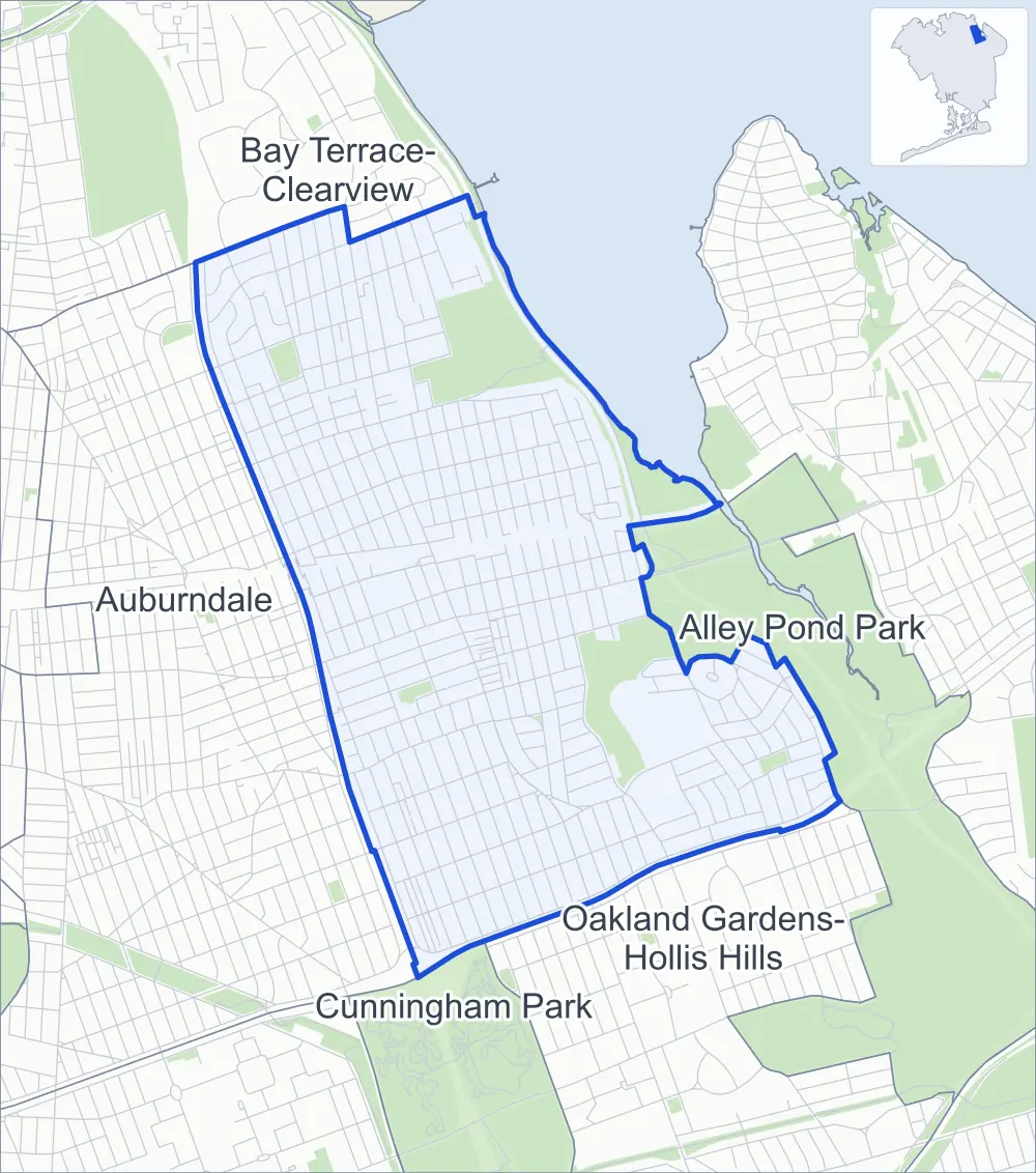
Bayside borders five areas, and Bell Boulevard holds more of its corners than any other street, 29 of 464.
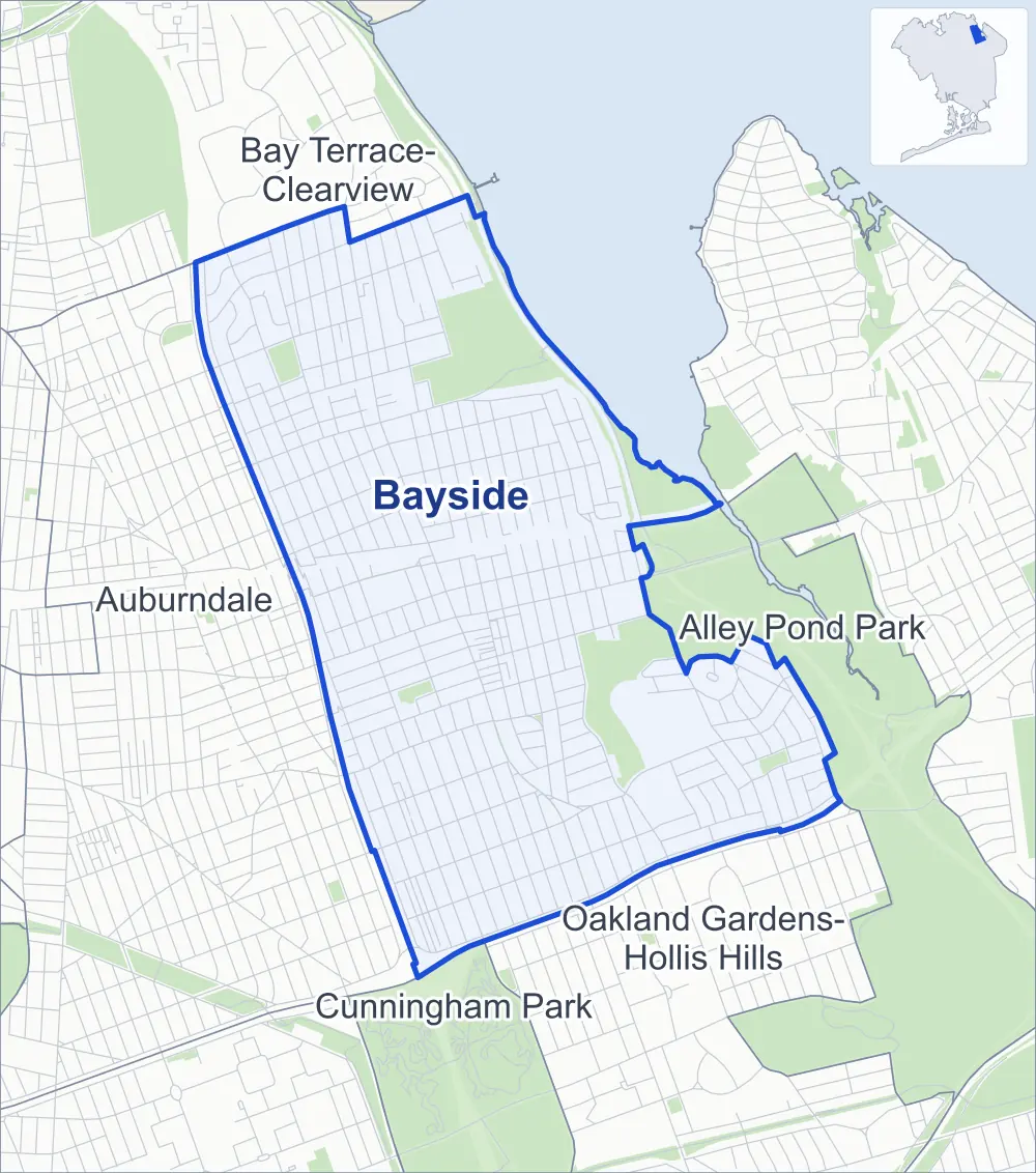
- Bayside
- A neighboring area
- Park
Neighborhood areas and streets: NYC Department of City Planning. Parks: NYC Parks. Stations: MTA.
Neighboring areas
- Bay Terrace-Clearview north
- Alley Pond Park east
- Oakland Gardens-Hollis Hills southeast
- Cunningham Park south
- Auburndale west
Getting around
Buses on 12 routes stop in or at the edge of Bayside.
- 8 local bus routes
- 4 express bus routes
Local bus routes
- Q12
- Q13
- Q27
- Q28
- Q30
- Q31
- Q74
- Q75
Express bus routes
- QM5
- QM8
- QM20
- QM35
Safety record
Between 2021 and 2025, its corners averaged fewer police-reported crashes than the average Queens corner.
- 1,233 police-reported crashes at its corners
- 2.7 a corner, on average
- 5.2 the average Queens corner
- 145 corners with a clean record
Signal or safety changes on City record, at 20 of its corners
- Accessible pedestrian signals
- 11
- Leading pedestrian intervals
- 7
- Turn calming
- 7
- Barnes Dance all-way crossings
- 1
- Safety Improvement Projects
- 1
Camera tickets
In 2025 its corners had more school-zone speed camera tickets than red-light or bus-lane tickets.
- 0 red-light camera tickets
- 24,455 school-zone speed camera tickets at 17 corners
- 0 bus-lane camera tickets
- Most speed tickets
- Horace Harding Expressway & Springfield Boulevard, 10,445
People and homes
The 2020 Census counted 35,588 residents in Bayside, about 14,100 per square mile.
- 13,486 homes, 2020 Census
- 393 homes added since April 2010, net, by City Planning's count
Half of its 8,201 residential lots hold buildings from 1950 or earlier, and 27% of them date from before 1940, by the City's tax lot records.
Parks and landmarks
- Parkland
- 110.1 acres of NYC Parks property
- The largest pieces
- Alley Pond Park (42 acres), Crocheron Park (39.6 acres) and John Golden Park (17 acres)
- Designated landmark
- The Hawthorne Court Apartments
Streets and trees
- Trees
- 9,785 in NYC Parks' records, most often London planetree, pin oak and Norway maple
- Street with the most corners
- Bell Boulevard, with 29 of the area's 464
- Height above sea level
- From 23 feet at 28th Avenue & 216th Street to 123 feet at 58th Avenue & 229th Street
- Honorary street names
- 5 at its corners, enacted by local law
Schools and libraries
The City lists 11 schools and one library in Bayside.
- Public schools
- 8
- Charter and private schools
- 3
- Library
- Bayside Library
Public safety
How complaints are countedIn 2025 the NYPD recorded 423 major felonies at places in Bayside.
Recorded by the NYPD at places in Bayside
- 369 major felonies in 2024
- 704 other felonies, misdemeanors and violations in 2025
In 2025, on the streets along the edge of Bayside, the NYPD recorded another nine major felonies. Counting the streets along its edge, in 2025 the NYPD recorded 12.1 major felonies for every thousand residents the 2020 Census counted in Bayside.
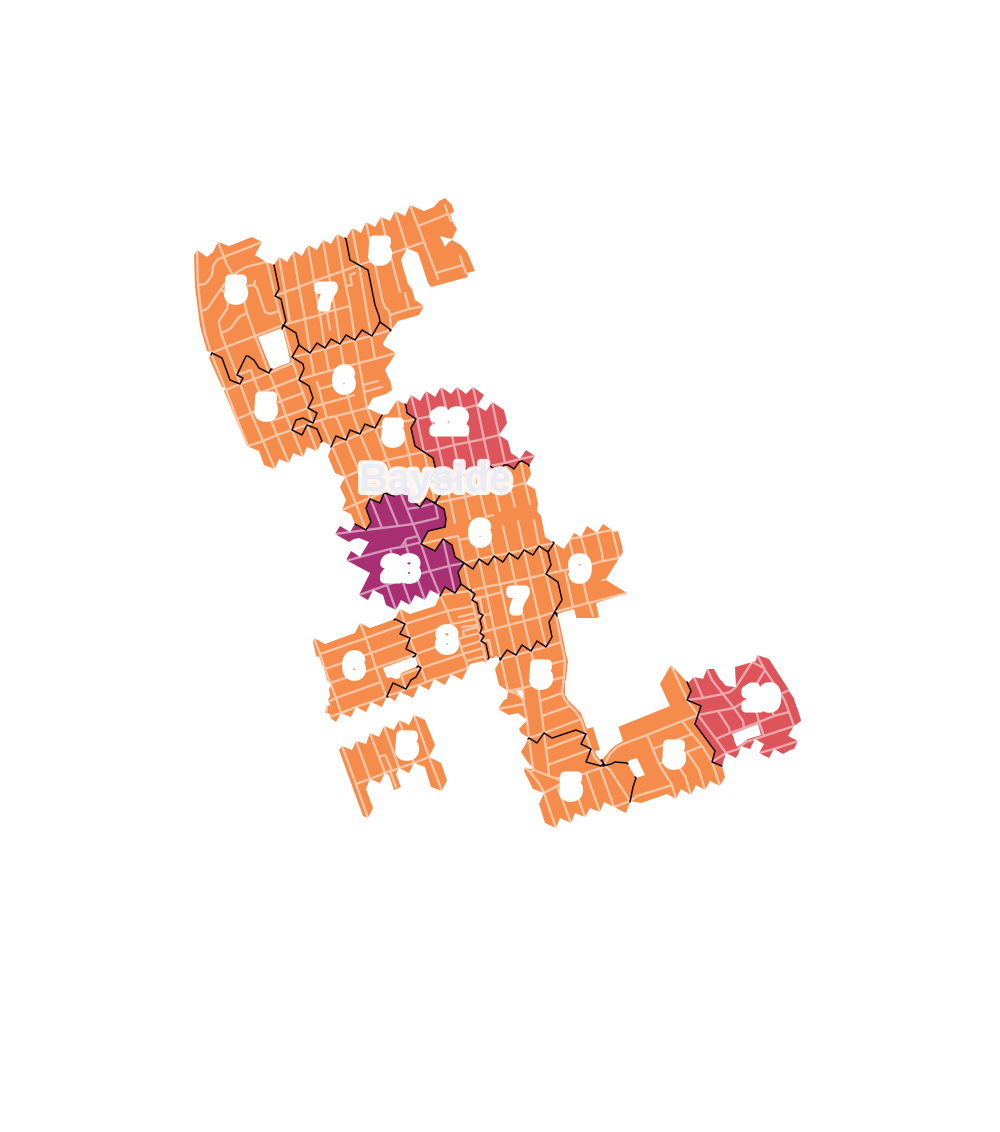
- 5 to 9
- 10 to 19
- 20 to 49
- 50 to 99
- 100 or more
- Not shaded: fewer than 5, held back under the rules in How complaints are counted, parks and public-housing grounds, and land in no patch
- Police precinct
- 111th
From January to June 2026 the NYPD recorded 189 major felonies at places in Bayside, against 184 in the same months of 2025.
Sources: the NYPD's Complaint Data Historic, updated April 28, 2026, and Complaint Data Current (Year To Date), updated July 27, 2026, on NYC Open Data. Figures to June 30, 2026.
Street corners
- 26th Avenue & 213th Street
- 27th Avenue & Corporal Kennedy Street
- 28th Avenue & 208th Street
- 28th Avenue & 210th Place
- 28th Avenue & 211th Street
- 28th Avenue & 213th Street
- 28th Avenue & 214th Place
- 28th Avenue & 214th Street
- 28th Avenue & 216th Street
- 28th Avenue & Corporal Kennedy Street
- 28th Road & 209th Place
- 28th Road & Little Neck Boulevard
- 29th Avenue & 210th Place
- 29th Avenue & 214th Place
- 29th Avenue & 214th Street
- 29th Avenue & 215th Place
- 29th Avenue & 216th Street
- 30th Avenue & Corporal Kennedy Street
- 32nd Avenue & 208th Street
- 32nd Avenue & 210th Place
- 32nd Avenue & 210th Street
- 32nd Avenue & 211th Street
- 32nd Avenue & 212th Street
- 32nd Avenue & 213th Street
- 32nd Avenue & Bell Boulevard
- 32nd Avenue & Corporal Kennedy Street
- 33rd Avenue & 209th Street
- 33rd Avenue & 214th Place
- 33rd Avenue & 214th Street
- 33rd Avenue & 215th Place
- 33rd Avenue & Corporal Kennedy Street
- 34th Avenue & 208th Street
- 34th Avenue & 209th Street
- 34th Avenue & 210th Street
- 34th Avenue & 211th Street
- 34th Avenue & 213th Street
- 34th Avenue & 214th Lane
- 34th Avenue & 214th Place
- 34th Avenue & Corporal Kennedy Street
- 35th Avenue & 208th Street
- 35th Avenue & 209th Street
- 35th Avenue & 210th Street
- 35th Avenue & 211th Street
- 35th Avenue & 212th Street
- 35th Avenue & 213th Street
- 35th Avenue & 214th Lane
- 35th Avenue & 214th Place
- 35th Avenue & 215th Place
- 35th Avenue & 215th Street
- 35th Avenue & Bell Boulevard
- 35th Avenue & Corbett Road
- 35th Avenue & Corporal Kennedy Street
- 35th Avenue & Corporal Stone Street
- 36th Avenue & 209th Street
- 36th Avenue & 214th Place
- 36th Avenue & 215th Place
- 36th Avenue & 216th Street
- 36th Avenue & Corporal Kennedy Street
- 36th Avenue & Corporal Stone Street
- 37th Avenue & 221st Street
- 37th Avenue & 222nd Street
- 37th Avenue & 223rd Street
- 38th Avenue & 208th Street
- 38th Avenue & 209th Street
- 38th Avenue & 210th Street
- 38th Avenue & 211th Street
- 38th Avenue & 213th Street
- 38th Avenue & 214th Place
- 38th Avenue & 215th Place
- 38th Avenue & 215th Street
- 38th Avenue & 216th Street
- 38th Avenue & 218th Street
- 38th Avenue & 219th Street
- 38th Avenue & Corporal Kennedy Street
- 38th Avenue & Corporal Stone Street
- 39th Avenue & 208th Street
- 39th Avenue & 209th Street
- 39th Avenue & 210th Street
- 39th Avenue & 211th Street
- 39th Avenue & 212th Street
- 39th Avenue & 213th Street
- 39th Avenue & 214th Place
- 39th Avenue & 215th Place
- 39th Avenue & 215th Street
- 39th Avenue & 216th Street
- 39th Avenue & 217th Street
- 39th Avenue & 218th Street
- 39th Avenue & 219th Street
- 39th Avenue & 220th Street
- 39th Avenue & 221st Street
- 39th Avenue & 222nd Street
- 39th Avenue & 223rd Street
- 39th Avenue & Bell Boulevard
- 39th Avenue & Corporal Kennedy Street
- 39th Avenue & Corporal Stone Street
- 40th Avenue & Corporal Stone Street
- 41st Avenue & 208th Street
- 41st Avenue & 209th Street
- 41st Avenue & 210th Street
- 41st Avenue & 211th Street
- 41st Avenue & 212th Street
- 41st Avenue & 213th Street
- 41st Avenue & 221st Street
- 41st Avenue & 222nd Street
- 41st Avenue & 223rd Street
- 41st Avenue & Bell Boulevard
- 41st Avenue & Corporal Kennedy Street
- 42nd Avenue & 214th Place
- 42nd Avenue & 215th Place
- 42nd Avenue & 216th Street
- 42nd Avenue & Corporal Kennedy Street
- 43rd Avenue & 208th Street
- 43rd Avenue & 209th Street
- 43rd Avenue & 210th Street
- 43rd Avenue & 211th Street
- 43rd Avenue & 212th Street
- 43rd Avenue & 213th Street
- 43rd Avenue & 214th Place
- 43rd Avenue & 215th Place
- 43rd Avenue & 215th Street
- 43rd Avenue & 216th Street
- 43rd Avenue & 217th Street
- 43rd Avenue & 218th Street
- 43rd Avenue & 219th Street
- 43rd Avenue & 220th Place
- 43rd Avenue & 220th Street
- 43rd Avenue & 221st Street
- 43rd Avenue & 222nd Street
- 43rd Avenue & 223rd Street
- 43rd Avenue & Bell Boulevard
- 43rd Avenue & Corporal Kennedy Street
- 45th Road & Oceania Street
- 46th Avenue & 206th Street
- 46th Avenue & 211th Street
- 46th Avenue & 215th Place
- 46th Avenue & 216th Street
- 46th Avenue & 218th Street
- 46th Avenue & 220th Place
- 46th Avenue & Oceania Street
- 46th Road & 206th Street
- 46th Road & Oceania Street
- 47th Avenue & 206th Street
- 47th Avenue & 207th Street
- 47th Avenue & 208th Street
- 47th Avenue & 210th Street
- 47th Avenue & 211th Street
- 47th Avenue & 212th Street
- 47th Avenue & 213th Street
- 47th Avenue & 215th Place
- 47th Avenue & 215th Street
- 47th Avenue & 216th Street
- 47th Avenue & 217th Street
- 47th Avenue & 218th Street
- 47th Avenue & Bell Boulevard
- 47th Avenue & Oceania Street
- 48th Avenue & 206th Street
- 48th Avenue & 207th Street
- 48th Avenue & 208th Street
- 48th Avenue & 210th Street
- 48th Avenue & 211th Street
- 48th Avenue & 213th Street
- 48th Avenue & 215th Place
- 48th Avenue & 215th Street
- 48th Avenue & 216th Street
- 48th Avenue & 216th Street at 49th Avenue
- 48th Avenue & Oceania Street
- 50th Avenue & 206th Street
- 50th Avenue & 207th Street
- 50th Avenue & 208th Street
- 50th Avenue & 210th Street
- 50th Avenue & 211th Street
- 50th Avenue & 213th Street
- 50th Avenue & 215th Street
- 50th Avenue & 216th Street
- 50th Avenue & 230th Street
- 50th Avenue & 231st Street
- 50th Avenue & Oceania Street
- 51st Avenue & 214th Street
- 51st Avenue & 216th Street
- 53rd Avenue & 206th Street
- 53rd Avenue & 207th Street
- 53rd Avenue & 208th Street
- 53rd Avenue & 210th Street
- 53rd Avenue & 211th Street
- 53rd Avenue & 212th Street
- 53rd Avenue & 213th Street
- 53rd Avenue & 214th Street
- 53rd Avenue & 215th Street
- 53rd Avenue & 217th Street
- 53rd Avenue & 228th Street
- 53rd Avenue & 229th Street
- 53rd Avenue & 230th Street
- 53rd Avenue & Bell Boulevard
- 53rd Avenue & Cloverdale Boulevard
- 53rd Avenue & East Hampton Boulevard
- 53rd Avenue & Horatio Parkway
- 53rd Avenue & Oceania Street
- 56th Avenue & 206th Street
- 56th Avenue & 207th Street
- 56th Avenue & 208th Street
- 56th Avenue & 210th Street
- 56th Avenue & 211th Street
- 56th Avenue & 212th Street
- 56th Avenue & 213th Street
- 56th Avenue & 214th Street
- 56th Avenue & 215th Street
- 56th Avenue & 217th Street
- 56th Avenue & 218th Street
- 56th Avenue & 219th Street
- 56th Avenue & 220th Street
- 56th Avenue & 223rd Street
- 56th Avenue & 226th Street
- 56th Avenue & 228th Street
- 56th Avenue & 229th Street
- 56th Avenue & 230th Street
- 56th Avenue & 231st Street
- 56th Avenue & Bell Boulevard
- 56th Avenue & Cloverdale Boulevard
- 56th Avenue & East Hampton Boulevard
- 56th Avenue & Luke Place
- 56th Avenue & Oceania Street
- 56th Road & East Hampton Boulevard
- 57th Avenue & 225th Street
- 57th Avenue & 226th Street
- 57th Avenue & 228th Street
- 57th Avenue & 229th Street
- 57th Avenue & 231st Street
- 57th Avenue & Cloverdale Boulevard
- 57th Avenue & East Hampton Boulevard
- 57th Road & Cloverdale Boulevard
- 57th Road & East Hampton Boulevard
- 58th Avenue & 206th Street
- 58th Avenue & 207th Street
- 58th Avenue & 208th Street
- 58th Avenue & 210th Street
- 58th Avenue & 211th Street
- 58th Avenue & 212th Street
- 58th Avenue & 213th Street
- 58th Avenue & 214th Street
- 58th Avenue & 215th Street
- 58th Avenue & 217th Street
- 58th Avenue & 218th Street
- 58th Avenue & 219th Street
- 58th Avenue & 220th Street
- 58th Avenue & 223rd Street
- 58th Avenue & 229th Street
- 58th Avenue & 230th Street
- 58th Avenue & Bell Boulevard
- 58th Avenue & East Hampton Boulevard
- 58th Avenue & Oceania Street
- 58th Road & East Hampton Boulevard
- 59th Avenue & 223rd Place
- 59th Avenue & 226th Street
- 59th Avenue & Cloverdale Boulevard
- 206th Street & 45th Drive
- 206th Street & 46th Avenue Pedestrian Overpass
- 206th Street & 47th Road
- 208th Street & 30th Avenue
- 208th Street & 32nd Drive
- 208th Street & 33rd Avenue
- 208th Street & 36th Avenue
- 208th Street & 42nd Avenue
- 209th Street & 33rd Road
- 209th Street & 34th Road
- 209th Street & 42nd Avenue
- 210th Street & 26th Avenue
- 210th Street & 27th Avenue
- 210th Street & 28th Avenue
- 210th Street & 29th Avenue
- 210th Street & 30th Avenue
- 210th Street & 33rd Avenue
- 210th Street & 33rd Road
- 210th Street & 34th Road
- 210th Street & 36th Avenue
- 210th Street & 46th Road
- 211th Street & 29th Avenue
- 211th Street & 33rd Avenue
- 211th Street & 33rd Road
- 211th Street & 34th Road
- 211th Street & 36th Avenue
- 211th Street & 45th Drive
- 211th Street & 45th Road
- 211th Street & 46th Road
- 212th Street & 28th Avenue
- 212th Street & 29th Avenue
- 212th Street & 33rd Avenue
- 212th Street & 33rd Road
- 212th Street & 36th Avenue
- 212th Street & 38th Avenue
- 212th Street & 48th Avenue
- 212th Street & 50th Avenue
- 213th Street & 29th Avenue
- 213th Street & 33rd Avenue
- 213th Street & 33rd Road
- 213th Street & 34th Road
- 213th Street & 36th Avenue
- 213th Street & 42nd Avenue
- 214th Place & 32nd Road
- 214th Place & 33rd Road
- 214th Place & 40th Avenue
- 214th Street & 33rd Road
- 215th Place & 32nd Road
- 215th Place & 33rd Road
- 215th Place & 40th Avenue
- 215th Street & 28th Avenue
- 215th Street & 29th Avenue
- 215th Street & 32nd Road
- 215th Street & 36th Avenue
- 215th Street & 40th Avenue
- 215th Street & 42nd Avenue
- 215th Street & 45th Drive
- 215th Street & 45th Road
- 215th Street & 46th Avenue
- 215th Street & 46th Road
- 215th Street & 49th Avenue
- 215th Street & 51st Avenue
- 216th Street & 28th Road
- 216th Street & 31st Road
- 216th Street & 40th Avenue
- 216th Street & Corbett Road
- 217th Street & 36th Avenue
- 217th Street & 38th Avenue
- 217th Street & 40th Avenue
- 217th Street & 46th Avenue
- 217th Street & 47th Road
- 217th Street & 48th Avenue
- 217th Street & 49th Avenue
- 217th Street & 50th Avenue
- 217th Street & 51st Avenue
- 217th Street & 54th Avenue
- 217th Street & Corbett Road
- 217th Street & Luke Place
- 218th Street & 31st Road
- 218th Street & 36th Avenue
- 218th Street & 40th Avenue
- 219th Street & 36th Avenue
- 219th Street & 40th Avenue
- 220th Street & 38th Avenue
- 220th Street & 40th Avenue
- 220th Street & 46th Avenue
- 221st Street & 36th Avenue
- 221st Street & 38th Avenue
- 221st Street & 40th Avenue
- 221st Street & Corbett Road
- 222nd Street & 38th Avenue
- 223rd Street & 38th Avenue
- 223rd Street & 46th Avenue
- 223rd Street & 56th Road
- 223rd Street & 57th Avenue
- 223rd Street & 59th Avenue
- 223rd Street & Mia Drive
- 224th Street & 57th Avenue
- 224th Street & 59th Avenue
- 225th Street & 59th Avenue
- 226th Street & 56th Road
- 226th Street & 57th Road
- 228th Street & 57th Road
- 228th Street & Hoxie Drive
- 229th Street & 57th Road
- 229th Street & Hoxie Drive
- 230th Street & 57th Avenue
- 230th Street & 57th Road
- 230th Street & 58th Road
- 230th Street & Horatio Parkway
- 230th Street & Hoxie Drive
- 231st Street & East Hampton Boulevard
- Bell Boulevard & 28th Avenue
- Bell Boulevard & 29th Avenue
- Bell Boulevard & 33rd Avenue
- Bell Boulevard & 33rd Road
- Bell Boulevard & 34th Road
- Bell Boulevard & 36th Avenue
- Bell Boulevard & 38th Avenue
- Bell Boulevard & 40th Avenue
- Bell Boulevard & 41st Road
- Bell Boulevard & 42nd Avenue
- Bell Boulevard & 45th Drive
- Bell Boulevard & 45th Road
- Bell Boulevard & 46th Avenue
- Bell Boulevard & 46th Road
- Bell Boulevard & 48th Avenue
- Bell Boulevard & 50th Avenue
- Bell Boulevard & 51st Avenue
- Bell Boulevard & 216th Street
- Bell Boulevard & Luke Place
- Clearview Expressway & 26th Avenue (east)
- Clearview Expressway & 26th Avenue (west)
- Clearview Expressway & 27th Avenue
- Clearview Expressway & 28th Avenue
- Clearview Expressway & 35th Avenue
- Clearview Expressway & 43rd Avenue
- Clearview Expressway & 46th Avenue Pedestrian Overpass
- Clearview Expressway & 58th Avenue
- Clearview Expressway & 206th Street
- Clearview Expressway & 207th Street
- Clearview Expressway & 207th Street Footbridge
- Clearview Expressway & Boyce Avenue
- Cloverdale Boulevard & Horatio Parkway at Birmington Parkway
- Cloverdale Boulevard & Horatio Parkway at Garland Drive
- Cloverdale Boulevard & Hoxie Drive
- Corporal Kennedy Street & 28th Road
- Corporal Kennedy Street & 33rd Road
- Corporal Kennedy Street & 34th Road
- Cross Island Parkway & 35th Avenue Pedestrian Overpass
- Garland Drive & Enfield Place
- Horace Harding Expressway & 206th Street
- Horace Harding Expressway & 207th Street
- Horace Harding Expressway & 208th Street
- Horace Harding Expressway & 210th Street
- Horace Harding Expressway & 211th Street
- Horace Harding Expressway & 212th Street
- Horace Harding Expressway & 213th Street
- Horace Harding Expressway & 215th Street
- Horace Harding Expressway & 217th Street
- Horace Harding Expressway & 219th Street
- Horace Harding Expressway & 220th Street
- Horace Harding Expressway & 223rd Place
- Horace Harding Expressway & East Hampton Boulevard
- Horace Harding Expressway & Long Island Expressway
- Horace Harding Expressway & Long Island Expressway (Exit 28)
- Horace Harding Expressway & Long Island Expressway (Exit 29)
- Horace Harding Expressway & Oceania Street
- Horace Harding Expressway & Springfield Boulevard
- Horatio Parkway & 49th Road
- Horatio Parkway & East Hampton Boulevard
- Kenilworth Drive & Enfield Place
- Long Island Expressway & Clearview Expressway
- Long Island Expressway & East Hampton Boulevard
- Northern Boulevard & 207th Street
- Northern Boulevard & 208th Street
- Northern Boulevard & 209th Street
- Northern Boulevard & 210th Street
- Northern Boulevard & 211th Street
- Northern Boulevard & 212th Street
- Northern Boulevard & 213th Street
- Northern Boulevard & 214th Place
- Northern Boulevard & 215th Place
- Northern Boulevard & 215th Street
- Northern Boulevard & 216th Street
- Northern Boulevard & 217th Street
- Northern Boulevard & 218th Street
- Northern Boulevard & 220th Place
- Northern Boulevard & 220th Street
- Northern Boulevard & 221st Street
- Northern Boulevard & 222nd Street
- Northern Boulevard & 223rd Street
- Northern Boulevard & Bell Boulevard
- Northern Boulevard & Corporal Kennedy Street
- Northern Boulevard & Cross Island Parkway
- Northern Boulevard & Oceania Street
- Northern Boulevard & Springfield Boulevard
- Oceania Street & 45th Drive
- Springfield Boulevard & 46th Avenue
- Springfield Boulevard & 47th Avenue
- Springfield Boulevard & 47th Road
- Springfield Boulevard & 48th Avenue
- Springfield Boulevard & 49th Avenue
- Springfield Boulevard & 50th Avenue
- Springfield Boulevard & 51st Avenue
- Springfield Boulevard & 53rd Avenue
- Springfield Boulevard & 54th Avenue
- Springfield Boulevard & 56th Avenue
- Springfield Boulevard & 58th Avenue
- Springfield Boulevard & 59th Avenue
How the figures above are measured: Methodology.