Kew Gardens Hills
Neighborhood · Queens
Kew Gardens Hills spreads east from Flushing Meadows-Corona Park toward Kissena and Parsons Boulevards, south of the Long Island Expressway.
- 1.23 square miles
- 36,009 residents, 2020 Census
- 171 street corners
- 19 bus routes
Once called Queens Valley, the area was farmland, much of it sold to golf and country clubs by the 1920s; developers renamed it for the prestige of nearby Kew Gardens, and growth followed a 1936 subway line there and the 1939 World's Fair. Queens College, opened in 1937, anchors its northern end, and Parkway Village, a Colonial Revival complex built in the late 1940s for United Nations employees, joined the National Register in 2012. Main Street has many kosher restaurants and Jewish-themed stores.
Sources: Kew Gardens Hills, Queens (Wikipedia); Kew Gardens Hills (Queens Community Board 8); NPGallery Asset Detail: Parkway Village (National Park Service); Queens College, City University of New York (Wikipedia).
Kew Gardens Hills borders five areas, and 147th Street holds more of its corners than any other street, 25 of 171.
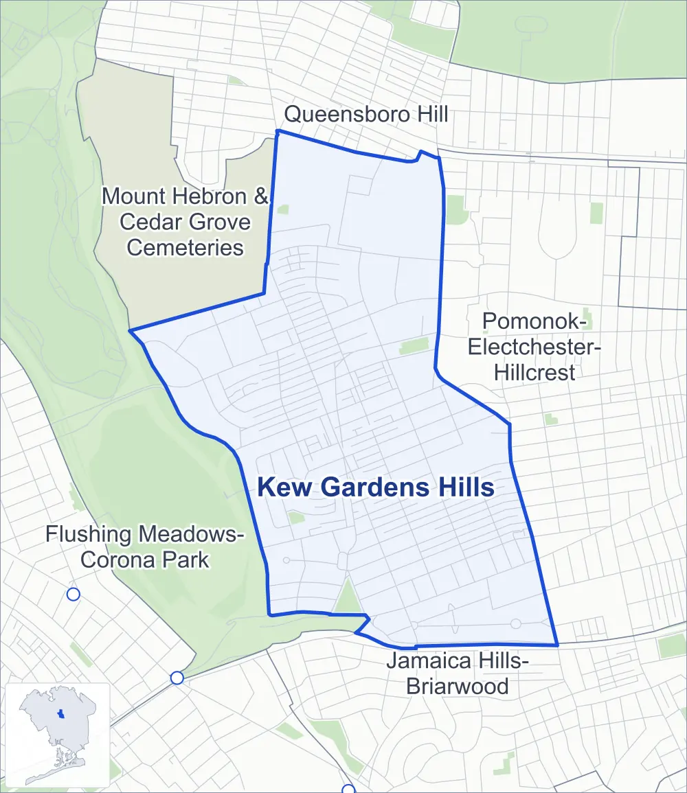
- Kew Gardens Hills
- A neighboring area
- Park
- Another station
Neighborhood areas and streets: NYC Department of City Planning. Parks: NYC Parks. Stations: MTA.
Neighboring areas
- Queensboro Hill north
- Pomonok-Electchester-Hillcrest east
- Jamaica Hills-Briarwood southeast
- Flushing Meadows-Corona Park southwest
- Mount Hebron & Cedar Grove Cemeteries northwest
Getting around
Buses on 19 routes stop in or at the edge of Kew Gardens Hills.
- 10 local bus routes
- 9 express bus routes
Local bus routes
- Q17
- Q20
- Q25
- Q44-SBS
- Q45
- Q46
- Q48
- Q64
- Q74
- Q88
Express bus routes
- QM1
- QM4
- QM5
- QM6
- QM7
- QM8
- QM31
- QM35
- QM44
Safety record
Between 2021 and 2025, its corners averaged fewer police-reported crashes than the average Queens corner.
- 681 police-reported crashes at its corners
- 4.0 a corner, on average
- 5.2 the average Queens corner
- 40 corners with a clean record
Signal or safety changes on City record, at 22 of its corners
- Leading pedestrian intervals
- 15
- Accessible pedestrian signals
- 5
- Turn calming
- 2
- Barnes Dance all-way crossings
- 2
- Safety Improvement Projects
- 2
Camera tickets
In 2025 its corners had more school-zone speed camera tickets than red-light or bus-lane tickets.
- 0 red-light camera tickets
- 12,868 school-zone speed camera tickets at ten corners
- 0 bus-lane camera tickets
- Most speed tickets
- Union Turnpike & Main Street, 8,033
People and homes
The 2020 Census counted 36,009 residents in Kew Gardens Hills, about 29,300 per square mile.
- 13,714 homes, 2020 Census
- 214 homes added since April 2010, net, by City Planning's count
Half of its 3,518 residential lots hold buildings from 1945 or earlier, and 6% of them date from before 1940, by the City's tax lot records.
Parks
- Parkland
- 7.4 acres of NYC Parks property
- The largest pieces
- Judge Moses Weinstein Playground (3.2 acres), Vleigh Playground (2.2 acres) and Queens Valley Playground (1 acre)
Streets and trees
- Trees
- 4,017 in NYC Parks' records, most often London planetree, pin oak and thornless honeylocust
- Street with the most corners
- 147th Street, with 25 of the area's 171
- Height above sea level
- From 27 feet at 136th Street & Park Drive East to 119 feet at Parsons Boulevard & Village Road at 82nd Drive
- Honorary street names
- 6 at its corners, enacted by local law
Schools and libraries
The City lists 15 schools and one library in Kew Gardens Hills.
- Public schools
- 8
- Charter and private schools
- 7
- Library
- Kew Gardens Hills Library
Public art
The City's public art inventory lists one work in Kew Gardens Hills: Haym Salomon (1976).
- 1 work of public art
Public safety
How complaints are countedIn 2025 the NYPD recorded 215 major felonies at places in Kew Gardens Hills.
Recorded by the NYPD at places in Kew Gardens Hills
- 219 major felonies in 2024
- 563 other felonies, misdemeanors and violations in 2025
In 2025, on the streets along the edge of Kew Gardens Hills, the NYPD recorded another 88 major felonies. Counting the streets along its edge, in 2025 the NYPD recorded 8.4 major felonies for every thousand residents the 2020 Census counted in Kew Gardens Hills.
- Police precinct
- 107th
From January to June 2026 the NYPD recorded 125 major felonies at places in Kew Gardens Hills, against 103 in the same months of 2025.
Sources: the NYPD's Complaint Data Historic, updated April 28, 2026, and Complaint Data Current (Year To Date), updated July 27, 2026, on NYC Open Data. Figures to June 30, 2026.
Street corners
- 64th Avenue & Kissena Boulevard
- 69th Avenue & 140th Street
- 69th Road & 68th Drive
- 69th Road & 140th Street
- 70th Avenue & 137th Street
- 70th Road & Vleigh Place
- 71st Avenue & 141st Street
- 71st Avenue & Vleigh Place
- 71st Road & Vleigh Place
- 72nd Avenue & 136th Street
- 72nd Avenue & Park Drive East
- 72nd Avenue & Vleigh Place
- 72nd Drive & 72nd Crescent
- 72nd Drive & Vleigh Place
- 72nd Road & Vleigh Place
- 73rd Avenue & 141st Street
- 73rd Avenue & 153rd Street
- 73rd Avenue & Kissena Boulevard
- 73rd Avenue & Main Street
- 73rd Avenue & Main Street at Vleigh Place
- 73rd Terrace & 141st Place
- 75th Avenue & 153rd Street
- 75th Avenue & Vleigh Place
- 75th Road & 137th Street
- 75th Road & 141st Place
- 76th Avenue & 137th Street
- 76th Avenue & 141st Place
- 76th Avenue & Vleigh Place
- 76th Road & 137th Street
- 76th Road & Vleigh Place
- 77th Avenue & 137th Street
- 77th Avenue & 138th Street
- 77th Avenue & 153rd Street
- 77th Avenue & Park Drive East
- 77th Avenue & Vleigh Place
- 77th Road & Vleigh Place
- 78th Avenue & 138th Street
- 78th Avenue & 153rd Street
- 78th Road & Vleigh Place
- 79th Avenue & 152nd Street
- 136th Street & 68th Drive
- 136th Street & 70th Road
- 136th Street & 71st Road
- 136th Street & 73rd Terrace
- 136th Street & Park Drive East
- 137th Street & 70th Road
- 137th Street & 72nd Road
- 137th Street & 73rd Terrace
- 138th Street & 68th Drive
- 138th Street & 78th Drive
- 138th Street & 78th Road
- 139th Street & 72nd Road
- 139th Street & 73rd Terrace
- 140th Street & 68th Drive
- 141st Street & 68th Drive
- 141st Street & 70th Avenue
- 141st Street & 70th Road
- 141st Street & 71st Road
- 141st Street & 72nd Avenue
- 141st Street & 72nd Drive
- 141st Street & 72nd Road
- 141st Street & 73rd Terrace
- 141st Street & 77th Avenue
- 141st Street & 77th Road
- 141st Street & 78th Avenue
- 141st Street & 78th Avenue at Vleigh Place
- 141st Street & 78th Road
- 141st Street & 79th Avenue
- 141st Street & 81st Avenue
- 141st Street & Jewel Avenue
- 141st Street & Vleigh Place
- 146th Street & 79th Avenue
- 147th Street & 68th Avenue
- 147th Street & 68th Drive
- 147th Street & 68th Road
- 147th Street & 69th Avenue
- 147th Street & 69th Road
- 147th Street & 70th Avenue
- 147th Street & 70th Road
- 147th Street & 71st Avenue
- 147th Street & 71st Road
- 147th Street & 72nd Avenue
- 147th Street & 72nd Drive
- 147th Street & 72nd Road
- 147th Street & 73rd Avenue
- 147th Street & 75th Avenue
- 147th Street & 75th Road
- 147th Street & 76th Avenue
- 147th Street & 76th Road
- 147th Street & 77th Avenue
- 147th Street & 77th Road
- 147th Street & 78th Avenue
- 147th Street & 78th Road
- 147th Street & 79th Avenue
- 147th Street & Jewel Avenue
- 147th Street & Melbourne Avenue
- 148th Street & Reeves Avenue
- 149th Street & 79th Avenue
- 149th Street & Melbourne Avenue
- 150th Street & 69th Road
- 150th Street & 70th Road
- 150th Street & 71st Avenue
- 150th Street & 71st Road
- 150th Street & 72nd Avenue
- 150th Street & 72nd Drive
- 150th Street & 72nd Road
- 150th Street & 73rd Avenue
- 150th Street & 75th Avenue
- 150th Street & 75th Road
- 150th Street & 76th Avenue
- 150th Street & 76th Road
- 150th Street & 77th Avenue
- 150th Street & 77th Road
- 150th Street & 78th Avenue
- 150th Street & 78th Road
- 150th Street & 79th Avenue
- 150th Street & Charter Road
- 150th Street & Goethals Avenue
- 150th Street & Jewel Avenue
- 152nd Street & Melbourne Avenue
- 153rd Street & 70th Road
- 153rd Street & 72nd Drive
- 153rd Street & 72nd Road
- 153rd Street & 76th Road
- 153rd Street & 77th Road
- 153rd Street & 78th Road
- 153rd Street & 79th Avenue
- Grand Central Parkway & Main Street at 141st Street
- Jewel Avenue & 69th Road at Park Drive East
- Jewel Avenue & 136th Street
- Jewel Avenue & 137th Street
- Jewel Avenue & 138th Street
- Jewel Avenue & 140th Street
- Jewel Avenue & 152nd Street
- Jewel Avenue & Kissena Boulevard
- Jewel Avenue & Park Drive East
- Kissena Boulevard & 65th Avenue
- Kissena Boulevard & 72nd Road
- Main Street & 68th Avenue
- Main Street & 68th Drive
- Main Street & 70th Road
- Main Street & 71st Avenue
- Main Street & 72nd Avenue
- Main Street & 72nd Drive
- Main Street & 75th Avenue
- Main Street & 76th Avenue
- Main Street & 76th Road
- Main Street & 77th Road
- Main Street & 78th Road
- Main Street & Gravett Road
- Main Street & Jewel Avenue
- Main Street & Melbourne Avenue
- Park Drive East & 73rd Terrace
- Park Drive East & 78th Drive
- Park Drive East & 78th Road
- Parsons Boulevard & 76th Avenue
- Parsons Boulevard & 77th Avenue
- Parsons Boulevard & 77th Road
- Parsons Boulevard & 79th Avenue
- Parsons Boulevard & Goethals Avenue
- Parsons Boulevard & Kissena Boulevard
- Parsons Boulevard & Village Road at 82nd Drive
- Reeves Avenue & 146th Place
- Reeves Avenue & 148th Place
- Union Turnpike & 147th Street
- Union Turnpike & 150th Street
- Union Turnpike & Main Street
- Union Turnpike & Vleigh Place
- Village Road & Charter Road (north-east)
- Village Road & Charter Road (south-west)
- Vleigh Place & 78th Drive
How the figures above are measured: Methodology.