East Elmhurst
Neighborhood · Queens
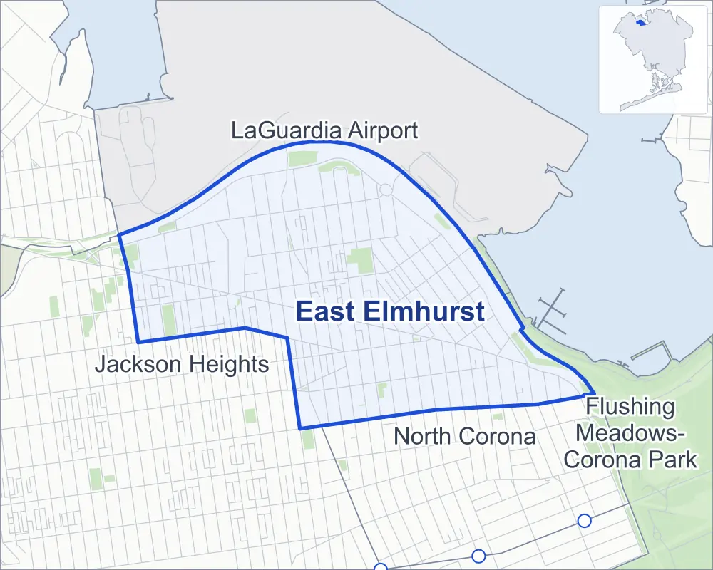
East Elmhurst stretches across northwestern Queens from Jackson Heights east toward Flushing Bay, between Northern Boulevard and the Grand Central Parkway, with LaGuardia Airport just beyond the parkway.
- 1.03 square miles
- 33,573 residents, 2020 Census
- 177 street corners
- 13 bus routes
From colonial times into the early 1900s much of the land was a broad marsh called Trains Meadow, part of the town of Newtown, and an amusement park on the Bowery Bay shore to the north later gave way to the airfield that became LaGuardia Airport, whose formal opening came in 1939. On Northern Boulevard, the Queens Public Library's Langston Hughes branch is home to the Black Heritage Reference Center of Queens County.
Sources: East Elmhurst, Queens (Wikipedia); Jackson Heights Historic District (designation report, October 19, 1993; copy) (NYC Landmarks Preservation Commission); Langston Hughes (Queens Public Library).
East Elmhurst borders four areas, and 25th Avenue holds more of its corners than any other street, 25 of 177.
- East Elmhurst
- A neighboring area
- Park
- Another station
Neighborhood areas and streets: NYC Department of City Planning. Parks: NYC Parks. Stations: MTA.
Neighboring areas
- LaGuardia Airport north
- Flushing Meadows-Corona Park east
- North Corona southeast
- Jackson Heights west
Getting around
Buses on 13 routes stop in or at the edge of East Elmhurst.
- 13 local bus routes
Local bus routes
- M60-SBS
- Q14
- Q19
- Q23
- Q33
- Q47
- Q49
- Q63
- Q66
- Q69
- Q70-SBS
- Q72
- Q90
Safety record
Between 2021 and 2025, its corners averaged more police-reported crashes than the average Queens corner.
- 1,384 police-reported crashes at its corners
- 7.8 a corner, on average
- 5.2 the average Queens corner
- 17 corners with a clean record
Signal or safety changes on City record, at 23 of its corners
- Accessible pedestrian signals
- 17
- Leading pedestrian intervals
- 16
- Turn calming
- 3
- Barnes Dance all-way crossings
- 1
- Safety Improvement Projects
- 1
Camera tickets
In 2025 its corners had more school-zone speed camera tickets than red-light or bus-lane tickets.
- 9,476 red-light camera tickets at four corners
- 23,298 school-zone speed camera tickets at eight corners
- 0 bus-lane camera tickets
- Most red-light tickets
- Northern Boulevard & 114th Street, 3,643
- Most speed tickets
- 108th Street & Astoria Boulevard, 8,071
People and homes
The 2020 Census counted 33,573 residents in East Elmhurst, about 32,600 per square mile.
- 9,940 homes, 2020 Census
- 588 homes added since April 2010, net, by City Planning's count
Half of its 4,467 residential lots hold buildings from 1935 or earlier, and 57% of them date from before 1940, by the City's tax lot records.
Parks
- Parkland
- 13.2 acres of NYC Parks property
- The largest pieces
- Helen Marshall Playground (4.2 acres), Gorman Playground (2.9 acres) and Overlook Park (2.6 acres)
Streets and trees
- Trees
- 3,425 in NYC Parks' records, most often pin oak, London planetree and green ash
- Street with the most corners
- 25th Avenue, with 25 of the area's 177
- Height above sea level
- From 20 feet at 88th Street & Astoria Boulevard to 92 feet at 32nd Avenue & 106th Street
- Honorary street names
- 12 at its corners, enacted by local law
Schools and libraries
The City lists four schools and two libraries in East Elmhurst.
- Public schools
- 4
- Libraries
- East Elmhurst Library and Langston Hughes Library
Bike share
By the station list of October 3, 2026, 26 bike-share stations stand in East Elmhurst.
- 26 bike-share stations
Public safety
How complaints are countedIn 2025 the NYPD recorded 332 major felonies at places in East Elmhurst.
Recorded by the NYPD at places in East Elmhurst
- 418 major felonies in 2024 86 fewer in 2025
- 1,050 other felonies, misdemeanors and violations in 2025
In 2025, on the streets along the edge of East Elmhurst, the NYPD recorded another 67 major felonies. Counting the streets along its edge, in 2025 the NYPD recorded 11.9 major felonies for every thousand residents the 2020 Census counted in East Elmhurst.
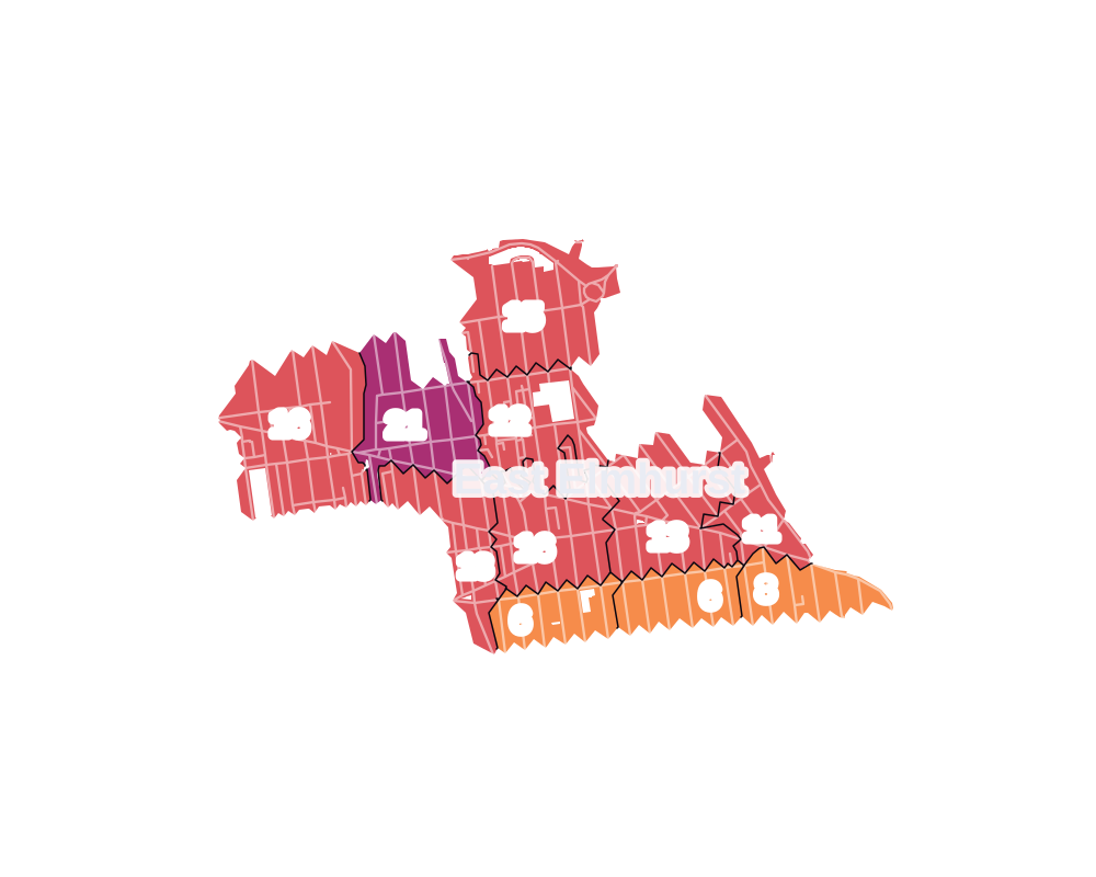
- 5 to 9
- 10 to 19
- 20 to 49
- 50 to 99
- 100 or more
- Not shaded: fewer than 5, held back under the rules in How complaints are counted, parks and public-housing grounds, and land in no patch
- Police precinct
- 115th
From January to June 2026 the NYPD recorded 131 major felonies at places in East Elmhurst, against 162 in the same months of 2025.
Sources: the NYPD's Complaint Data Historic, updated April 28, 2026, and Complaint Data Current (Year To Date), updated July 27, 2026, on NYC Open Data. Figures to June 30, 2026.
Street corners
- 23rd Avenue & 85th Street
- 23rd Avenue & 86th Street
- 23rd Avenue & 87th Street
- 23rd Avenue & 88th Street
- 23rd Avenue & 89th Street
- 23rd Avenue & 90th Street
- 23rd Avenue & 91st Street
- 23rd Avenue & 92nd Street
- 23rd Avenue & 93rd Street
- 23rd Avenue & 94th Street
- 23rd Avenue & 95th Street
- 23rd Avenue & 96th Street
- 23rd Avenue & 97th Street
- 23rd Avenue & 98th Street
- 23rd Avenue & 99th Street
- 23rd Avenue & 100th Street
- 23rd Avenue & Ditmars Boulevard Square
- 23rd Avenue & Planeview Park Path
- 24th Avenue & 91st Street
- 24th Avenue & 93rd Street
- 24th Avenue & 100th Street
- 24th Avenue & 101st Street
- 24th Avenue & Ericsson Street
- 24th Avenue & Gillmore Street
- 24th Avenue & Jackson Mill Road
- 24th Road & 90th Place
- 25th Avenue & 87th Street
- 25th Avenue & 90th Place
- 25th Avenue & 91st Street
- 25th Avenue & 93rd Street
- 25th Avenue & 94th Street
- 25th Avenue & 95th Street
- 25th Avenue & 96th Street
- 25th Avenue & 100th Street
- 25th Avenue & Astoria Boulevard
- 25th Avenue & Butler Street
- 25th Avenue & Curtis Street
- 25th Avenue & Ditmars Boulevard
- 25th Avenue & Ericsson Street
- 25th Avenue & Gillmore Street
- 25th Avenue & Humphreys Street
- 27th Avenue & 100th Street
- 27th Avenue & Butler Street
- 27th Avenue & Curtis Street
- 27th Avenue & Ericsson Street
- 27th Avenue & Gillmore Street
- 27th Avenue & Humphreys Street
- 27th Avenue & Kearney Street
- 27th Avenue & McIntosh Street
- 29th Avenue & Butler Street
- 29th Avenue & Curtis Street
- 29th Avenue & Ericsson Street
- 29th Avenue & Gillmore Street
- 29th Avenue & Humphreys Street
- 29th Avenue & McIntosh Street
- 30th Avenue & 91st Street
- 30th Avenue & 93rd Street
- 31st Avenue & 94th Street
- 31st Avenue & 95th Street
- 31st Avenue & 96th Street
- 31st Avenue & 97th Street
- 31st Avenue & 98th Street
- 31st Avenue & 99th Street
- 31st Avenue & 100th Street
- 31st Avenue & 101st Street
- 31st Avenue & 102nd Street
- 31st Avenue & 103rd Street
- 31st Avenue & Astoria Boulevard
- 31st Avenue & Buell Street
- 31st Avenue & Butler Street
- 31st Avenue & Couch Place
- 31st Avenue & Curtis Street
- 31st Avenue & Ditmars Boulevard
- 31st Avenue & Ericsson Street
- 31st Drive & Buell Street
- 32nd Avenue & 93rd Street
- 32nd Avenue & 94th Street
- 32nd Avenue & 95th Street
- 32nd Avenue & 96th Street
- 32nd Avenue & 97th Street
- 32nd Avenue & 98th Street
- 32nd Avenue & 99th Street
- 32nd Avenue & 100th Street
- 32nd Avenue & 101st Street
- 32nd Avenue & 102nd Street
- 32nd Avenue & 103rd Street
- 32nd Avenue & 104th Street
- 32nd Avenue & 105th Street
- 32nd Avenue & 106th Street
- 32nd Avenue & 107th Street
- 32nd Avenue & 108th Street
- 82nd Street & 24th Avenue
- 82nd Street & 30th Avenue
- 83rd Street & 24th Avenue
- 83rd Street & 25th Avenue
- 84th Street & 25th Avenue
- 85th Street & 24th Avenue
- 85th Street & 25th Avenue
- 85th Street & Astoria Boulevard
- 86th Street & 24th Avenue
- 86th Street & 25th Avenue
- 86th Street & 30th Avenue
- 86th Street & Ditmars Boulevard
- 87th Street & 24th Avenue
- 88th Street & 24th Avenue
- 88th Street & 25th Avenue
- 88th Street & 30th Avenue
- 88th Street & Astoria Boulevard
- 89th Street & 25th Avenue
- 90th Street & Ditmars Boulevard
- 92nd Street & 24th Avenue
- 92nd Street & 25th Avenue
- 92nd Street & 30th Avenue
- 92nd Street & Astoria Boulevard
- 92nd Street & Ditmars Boulevard
- 94th Street & 24th Avenue
- 94th Street & 30th Avenue
- 94th Street & Astoria Boulevard
- 94th Street & Ditmars Boulevard
- 94th Street & Grand Central Parkway
- 94th Street & Jackson Mill Road (north)
- 94th Street & Jackson Mill Road (south)
- 95th Street & 24th Avenue
- 95th Street & 30th Avenue
- 95th Street & Jackson Mill Road (north)
- 95th Street & Jackson Mill Road (south)
- 96th Street & 24th Avenue
- 96th Street & 30th Avenue
- 96th Street & Astoria Boulevard
- 96th Street & Jackson Mill Road (north)
- 96th Street & Jackson Mill Road (south)
- 97th Street & 24th Avenue
- 97th Street & 25th Avenue
- 97th Street & Astoria Boulevard
- 97th Street & Jackson Mill Road
- 98th Street & 24th Avenue
- 98th Street & 25th Avenue
- 98th Street & Astoria Boulevard
- 99th Street & 24th Avenue
- 99th Street & 25th Avenue
- 99th Street & 27th Avenue
- 100th Street & Astoria Boulevard
- 100th Street & Humphreys Street
- 100th Street & Kearney Street
- 100th Street & McIntosh Street
- 101st Street & Astoria Boulevard
- 102nd Street & Astoria Boulevard
- 108th Street & Astoria Boulevard
- 112th Street & Astoria Boulevard
- Astoria Boulevard & 112th Place
- Astoria Boulevard & Van Wyck Expressway
- Ditmars Boulevard & 27th Avenue
- Ditmars Boulevard & 29th Avenue
- Ditmars Boulevard & 31st Drive
- Ditmars Boulevard & 93rd Street
- Ditmars Boulevard & 100th Street
- Ditmars Boulevard & Astoria Boulevard
- Ditmars Boulevard & Ditmars Boulevard Square
- Ditmars Boulevard & Grand Central Parkway
- Ditmars Boulevard & Grand Central Parkway (Exit 8)
- Grand Central Parkway & 23rd Avenue
- Grand Central Parkway & 27th Avenue Pedestrian Overpass
- Grand Central Parkway & 82nd Street
- Grand Central Parkway & 94th Street
- Grand Central Parkway & La Guardia Airport Exit
- Grand Central Parkway & LGA Terminals B-C-D Access Road
- La Guardia Airport Exit & Ditmars Boulevard Square
- LGA Terminals C-D Access Road & Ditmars Boulevard Square
- Northern Boulevard & 97th Street
- Northern Boulevard & 100th Street
- Northern Boulevard & 101st Street
- Northern Boulevard & 104th Street
- Northern Boulevard & 105th Street
- Northern Boulevard & 107th Street
- Northern Boulevard & 114th Street
- Northern Boulevard & Junction Boulevard
- Whitestone Expressway & 111th Street
How the figures above are measured: Methodology.