Jackson Heights
Neighborhood · Queens
Jackson Heights lies in northwestern Queens north of Roosevelt Avenue, between the Brooklyn-Queens Expressway and Junction Boulevard.
- 1.41 square miles
- 101,848 residents, 2020 Census
- 253 street corners
- 4 subway stations
- 13 bus routes
A development company formed in 1909 built it on undeveloped farmland in the Trains Meadow section of old Newtown, named it for Jackson Avenue and coined the term garden apartment for its buildings set around private parks; settlement picked up after the elevated line on Roosevelt Avenue opened in 1917. Nearly 600 buildings from about 76th to 88th Streets form the Jackson Heights Historic District, designated in 1993. The New York Times has described Jackson Heights as New York's most culturally diverse neighborhood.
Sources: Jackson Heights Historic District (designation report, October 19, 1993; copy) (NYC Landmarks Preservation Commission); Jackson Heights (Wikipedia).
Jackson Heights borders seven areas, and 37th Avenue holds more of its corners than any other street, 30 of 253.
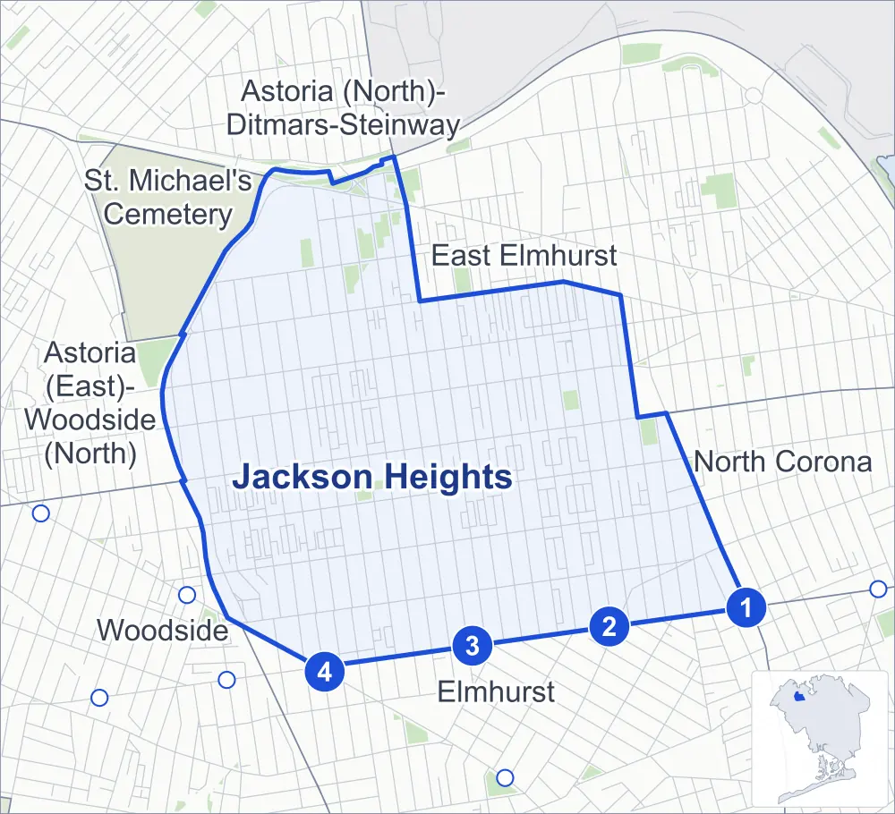
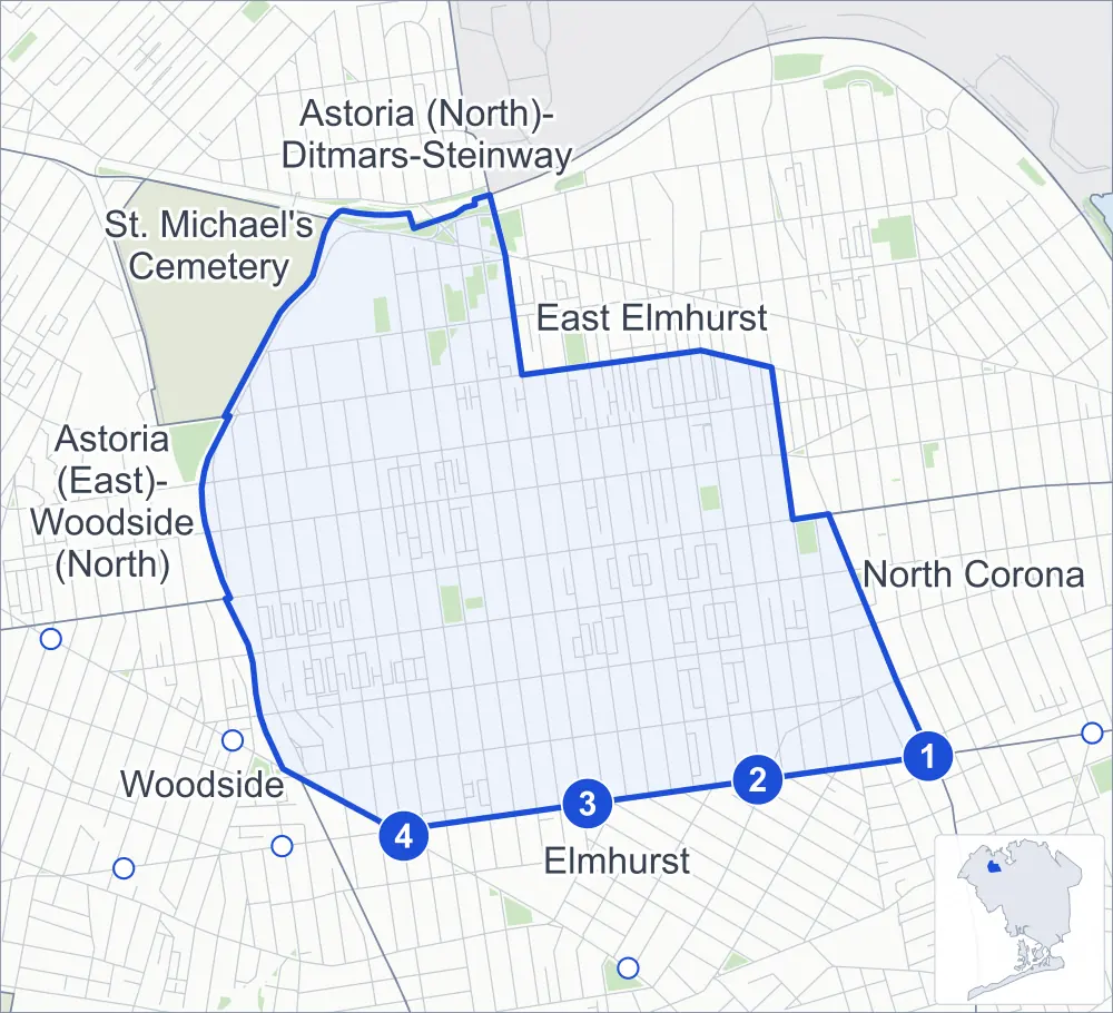
- Jackson Heights
- A neighboring area
- Park
- A station in the list
- Another station
Neighborhood areas and streets: NYC Department of City Planning. Parks: NYC Parks. Stations: MTA.
Neighboring areas
- Astoria (North)-Ditmars-Steinway north
- East Elmhurst northeast
- North Corona east
- Elmhurst south
- Woodside southwest
- Astoria (East)-Woodside (North) west
- St. Michael's Cemetery northwest
Subway stations
- Junction Blvd lines 7 accessible
- 90 St-Elmhurst Av lines 7
- 82 St-Jackson Hts lines 7
- 74 St-Broadway / Jackson Hts-Roosevelt Av lines 7 E F M R accessible
Getting around
Four subway stations and buses on 13 routes stop in or at the edge of Jackson Heights.
- 4 subway stations
- 2 of them listed by the MTA as fully accessible
- 13 local bus routes
Local bus routes
- M60-SBS
- Q19
- Q29
- Q32
- Q33
- Q47
- Q49
- Q63
- Q66
- Q69
- Q70-SBS
- Q72
- T320
Safety record
Between 2021 and 2025, its corners averaged more police-reported crashes than the average Queens corner.
- 2,946 police-reported crashes at its corners
- 11.6 a corner, on average
- 5.2 the average Queens corner
- 12 corners with a clean record
Signal or safety changes on City record, at 143 of its corners
- Leading pedestrian intervals
- 129
- Accessible pedestrian signals
- 53
- Turn calming
- 17
- Safety Improvement Projects
- 5
- Barnes Dance all-way crossings
- 4
Camera tickets
In 2025 its corners had more red-light camera tickets than school-zone speed or bus-lane tickets.
- 14,563 red-light camera tickets at one corner
- 9,134 school-zone speed camera tickets at 14 corners
- 0 bus-lane camera tickets
- Most red-light tickets
- 77th Street & Astoria Boulevard South, 14,563
- Most speed tickets
- 77th Street & 30th Avenue, 3,121
People and homes
The 2020 Census counted 101,848 residents in Jackson Heights, about 72,200 per square mile.
- 37,428 homes, 2020 Census
- 608 homes added since April 2010, net, by City Planning's count
Half of its 6,360 residential lots hold buildings from 1940 or earlier, and 50% of them date from before 1940, by the City's tax lot records.
Parks and landmarks
- Parkland
- 12.5 acres of NYC Parks property
- The largest pieces
- Travers Park (2 acres), LaGuardia Landing Lights (1.8 acres) and Northern Playground (1.7 acres)
- Historic district
- Jackson Heights Historic District, wholly or partly within Jackson Heights
Streets and trees
- Trees
- 5,956 in NYC Parks' records, most often London planetree, thornless honeylocust and pin oak
- Street with the most corners
- 37th Avenue, with 30 of the area's 253
- Height above sea level
- From 21 feet at 31st Avenue & 73rd Street to 81 feet at 32nd Avenue & 85th Street
- Honorary street names
- 23 at its corners, enacted by local law
Schools and libraries
The City lists 16 schools and one library in Jackson Heights.
- Public schools
- 10
- Charter and private schools
- 6
- Library
- Jackson Heights Library
Bike share
By the station list of October 3, 2026, 43 bike-share stations stand in Jackson Heights.
- 43 bike-share stations
Public safety
How complaints are countedIn 2025 the NYPD recorded 812 major felonies at places in Jackson Heights.
Recorded by the NYPD at places in Jackson Heights
- 1,024 major felonies in 2024
- 2,702 other felonies, misdemeanors and violations in 2025
In 2025, on the streets along the edge of Jackson Heights, the NYPD recorded another 349 major felonies. Counting the streets along its edge, in 2025 the NYPD recorded 11.4 major felonies for every thousand residents the 2020 Census counted in Jackson Heights.
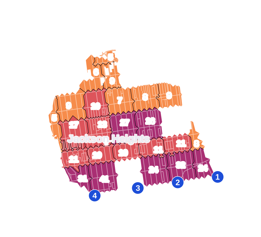
- 5 to 9
- 10 to 19
- 20 to 49
- 50 to 99
- 100 or more
- Not shaded: fewer than 5, held back under the rules in How complaints are counted, parks and public-housing grounds, and land in no patch
- Police precinct
- 115th
From January to June 2026 the NYPD recorded 379 major felonies at places in Jackson Heights, against 419 in the same months of 2025.
Sources: the NYPD's Complaint Data Historic, updated April 28, 2026, and Complaint Data Current (Year To Date), updated July 27, 2026, on NYC Open Data. Figures to June 30, 2026.
Street corners
- 25th Avenue & 71st Street
- 25th Avenue & 72nd Street
- 25th Avenue & 73rd Street
- 25th Avenue & Boody Street
- 30th Avenue & 68th Street
- 30th Avenue & 69th Street
- 30th Avenue & 70th Street
- 30th Avenue & 71st Street
- 30th Avenue & 72nd Street
- 30th Avenue & 73rd Street
- 30th Avenue & Boody Street
- 31st Avenue & 68th Street
- 31st Avenue & 69th Street
- 31st Avenue & 70th Street
- 31st Avenue & 71st Street
- 31st Avenue & 72nd Street
- 31st Avenue & 73rd Street
- 31st Avenue & 74th Street
- 31st Avenue & 75th Street
- 31st Avenue & 76th Street
- 31st Avenue & 77th Street
- 31st Avenue & 81st Street
- 31st Avenue & 82nd Street
- 31st Avenue & 83rd Street
- 31st Avenue & 84th Street
- 31st Avenue & 85th Street
- 31st Avenue & 86th Street
- 31st Avenue & 87th Street
- 31st Avenue & 89th Street
- 31st Avenue & 90th Street
- 31st Avenue & 91st Street
- 31st Avenue & 92nd Street
- 31st Avenue & 93rd Street
- 32nd Avenue & 68th Street
- 32nd Avenue & 69th Street
- 32nd Avenue & 70th Street
- 32nd Avenue & 71st Street
- 32nd Avenue & 72nd Street
- 32nd Avenue & 73rd Street
- 32nd Avenue & 74th Street
- 32nd Avenue & 75th Street
- 32nd Avenue & 76th Street
- 32nd Avenue & 77th Street
- 32nd Avenue & 81st Street
- 32nd Avenue & 82nd Street
- 32nd Avenue & 83rd Street
- 32nd Avenue & 84th Street
- 32nd Avenue & 85th Street
- 32nd Avenue & 86th Street
- 32nd Avenue & 87th Street
- 32nd Avenue & 89th Street
- 32nd Avenue & 90th Street
- 32nd Avenue & 91st Street
- 32nd Avenue & 92nd Street
- 34th Avenue & 69th Street
- 34th Avenue & 70th Street
- 34th Avenue & 71st Street
- 34th Avenue & 72nd Street
- 34th Avenue & 73rd Street
- 34th Avenue & 74th Street
- 34th Avenue & 75th Street
- 34th Avenue & 76th Street
- 34th Avenue & 77th Street
- 34th Avenue & 78th Street
- 34th Avenue & 81st Street
- 34th Avenue & 82nd Street
- 34th Avenue & 83rd Street
- 34th Avenue & 84th Street
- 34th Avenue & 85th Street
- 34th Avenue & 86th Street
- 34th Avenue & 87th Street
- 34th Avenue & 88th Street
- 34th Avenue & 89th Street
- 34th Avenue & 90th Street
- 34th Avenue & 91st Street
- 34th Avenue & 92nd Street
- 34th Avenue & 93rd Street
- 34th Avenue & 94th Street
- 35th Avenue & 69th Street
- 35th Avenue & 70th Street
- 35th Avenue & 72nd Street
- 35th Avenue & 73rd Street
- 35th Avenue & 74th Street
- 35th Avenue & 75th Street
- 35th Avenue & 76th Street
- 35th Avenue & 77th Street
- 35th Avenue & 78th Street
- 35th Avenue & 79th Street
- 35th Avenue & 81st Street
- 35th Avenue & 82nd Street
- 35th Avenue & 83rd Street
- 35th Avenue & 84th Street
- 35th Avenue & 85th Street
- 35th Avenue & 86th Street
- 35th Avenue & 87th Street
- 35th Avenue & 88th Street
- 35th Avenue & 89th Street
- 35th Avenue & 90th Street
- 35th Avenue & 91st Street
- 35th Avenue & 92nd Street
- 35th Avenue & 93rd Street
- 35th Avenue & 94th Street
- 35th Avenue & 95th Street
- 37th Avenue & 69th Street
- 37th Avenue & 71st Street
- 37th Avenue & 72nd Street
- 37th Avenue & 73rd Street
- 37th Avenue & 74th Street
- 37th Avenue & 75th Street
- 37th Avenue & 76th Street
- 37th Avenue & 77th Street
- 37th Avenue & 81st Street
- 37th Avenue & 82nd Street
- 37th Avenue & 83rd Street
- 37th Avenue & 84th Street
- 37th Avenue & 85th Street
- 37th Avenue & 86th Street
- 37th Avenue & 87th Street
- 37th Avenue & 89th Street
- 37th Avenue & 90th Street
- 37th Avenue & 91st Street
- 37th Avenue & 92nd Street
- 37th Avenue & 93rd Street
- 37th Avenue & 94th Street
- 37th Avenue & 95th Street
- 37th Avenue & Broadway
- 37th Avenue & Brooklyn-Queens Expressway
- 37th Avenue & Junction Boulevard
- 37th Avenue & Warren Street
- 68th Street & Brooklyn-Queens Expressway
- 69th Street & 35th Road
- 69th Street & 70th Street (north-west)
- 69th Street & 70th Street (south-east)
- 70th Street & 35th Road
- 70th Street & Boody Street
- 71st Street & 35th Road
- 74th Street & 30th Avenue
- 74th Street & 37th Road
- 75th Street & 25th Avenue
- 75th Street & 30th Avenue
- 75th Street & 37th Road
- 76th Street & 25th Avenue
- 76th Street & 30th Avenue
- 76th Street & 37th Road
- 77th Street & 24th Avenue
- 77th Street & 25th Avenue
- 77th Street & 30th Avenue
- 77th Street & 37th Road
- 77th Street & Astoria Boulevard South
- 78th Street & 24th Avenue
- 78th Street & 25th Avenue
- 78th Street & 30th Avenue
- 78th Street & 31st Avenue
- 78th Street & 32nd Avenue
- 78th Street & 37th Avenue
- 79th Street & 24th Avenue
- 79th Street & 25th Avenue
- 79th Street & 30th Avenue
- 79th Street & 31st Avenue
- 79th Street & 32nd Avenue
- 79th Street & 34th Avenue
- 79th Street & 37th Avenue
- 79th Street & Astoria Boulevard South
- 80th Street & 24th Avenue
- 80th Street & 25th Avenue
- 80th Street & 30th Avenue
- 80th Street & 31st Avenue
- 80th Street & 32nd Avenue
- 80th Street & 34th Avenue
- 80th Street & 35th Avenue
- 80th Street & 37th Avenue
- 80th Street & Astoria Boulevard at Astoria Boulevard North
- 80th Street & Astoria Boulevard at Astoria Boulevard South
- 80th Street & Roosevelt Avenue
- 81st Street & 24th Avenue
- 81st Street & 25th Avenue
- 81st Street & 30th Avenue
- 82nd Street & 25th Avenue
- 82nd Street & Astoria Boulevard
- 83rd Street & 30th Avenue
- 84th Street & 30th Avenue
- 85th Street & 30th Avenue
- 87th Street & 30th Avenue
- 88th Street & 31st Avenue
- 88th Street & 32nd Avenue
- 88th Street & 37th Avenue
- 89th Street & 30th Avenue
- 90th Street & 30th Avenue
- 91st Street & Elmhurst Avenue
- 92nd Street & Elmhurst Avenue
- 93rd Street & Elmhurst Avenue
- 94th Street & 34th Road
- 94th Street & Elmhurst Avenue
- Astoria Boulevard North & Grand Central Parkway
- Astoria Boulevard South & Astoria Boulevard North
- Astoria Boulevard South & Boody Street
- Astoria Boulevard South & Brooklyn-Queens Expressway at Grand Central Parkway
- Broadway & 72nd Street
- Broadway & 73rd Street
- Broadway & Brooklyn-Queens Expressway
- Brooklyn Queens Expressway East & 30th Avenue
- Brooklyn Queens Expressway East & Brooklyn-Queens Expressway
- Brooklyn Queens Expressway East & Brooklyn-Queens Expressway at I 278
- Brooklyn-Queens Expressway & 34th Avenue
- Brooklyn-Queens Expressway & 35th Avenue
- Brooklyn-Queens Expressway & Northern Boulevard
- Grand Central Parkway & 80th Street
- Grand Central Parkway & 81st Street
- Grand Central Parkway & Astoria Boulevard North
- Grand Central Parkway & Brooklyn-Queens Expressway
- Northern Boulevard & 69th Street
- Northern Boulevard & 70th Street
- Northern Boulevard & 71st Street
- Northern Boulevard & 72nd Street
- Northern Boulevard & 73rd Street
- Northern Boulevard & 74th Street
- Northern Boulevard & 75th Street
- Northern Boulevard & 76th Street
- Northern Boulevard & 77th Street
- Northern Boulevard & 78th Street
- Northern Boulevard & 79th Street
- Northern Boulevard & 80th Street
- Northern Boulevard & 81st Street
- Northern Boulevard & 82nd Street
- Northern Boulevard & 83rd Street
- Northern Boulevard & 84th Street
- Northern Boulevard & 85th Street
- Northern Boulevard & 86th Street
- Northern Boulevard & 87th Street
- Northern Boulevard & 88th Street
- Northern Boulevard & 89th Street
- Northern Boulevard & 90th Street
- Northern Boulevard & 91st Street
- Northern Boulevard & 92nd Street
- Northern Boulevard & 93rd Street
- Northern Boulevard & 94th Street
- Northern Boulevard & Brooklyn-Queens Expressway at I 278
- Roosevelt Avenue & 74th Street
- Roosevelt Avenue & 75th Street
- Roosevelt Avenue & 79th Street
- Roosevelt Avenue & 81st Street
- Roosevelt Avenue & 82nd Street
- Roosevelt Avenue & 88th Street
- Roosevelt Avenue & 91st Street
- Roosevelt Avenue & 92nd Street
- Roosevelt Avenue & 93rd Street
- Roosevelt Avenue & Baxter Avenue
- Roosevelt Avenue & Benham Street
- Roosevelt Avenue & Britton Avenue
- Roosevelt Avenue & Case Street
- Roosevelt Avenue & Elbertson Street
- Roosevelt Avenue & Junction Boulevard
- Roosevelt Avenue & Whitney Avenue
How the figures above are measured: Methodology.