Kew Gardens
Neighborhood · Queens
Kew Gardens sits in central Queens on the eastern edge of Forest Park, between Union Turnpike and Hillside Avenue, with Queens Borough Hall on Queens Boulevard at its northern end.
- 0.73 square miles
- 24,371 residents, 2020 Census
- 135 street corners
- 3 subway stations
- 17 bus routes
Albon P. Man acquired the land in 1868, and in the early 1900s his heirs laid out a planned community, naming it Kew and later Kew Gardens for the noted botanical gardens in England; a Long Island Rail Road station went up on Lefferts Boulevard in 1909. Its houses and courtyard apartment buildings of the 1920s and 1930s lean heavily on English and neo-Tudor styles. Maple Grove Cemetery, opened in 1875, lies along Kew Gardens Road.
Sources: Kew Gardens, Queens (Wikipedia); Kew Gardens (Queens Community Board 9); Neighborhoods (Queens Community Board 9).
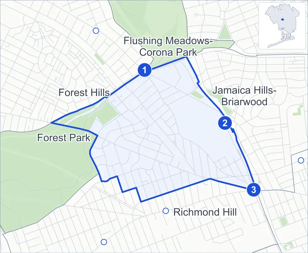
Kew Gardens borders five areas, and Kew Gardens Road holds more of its corners than any other street, 21 of 135.
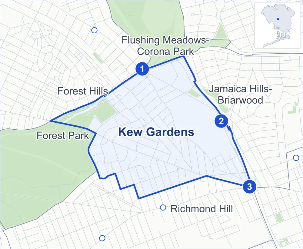
- Kew Gardens
- A neighboring area
- Park
- A station in the list
- Another station
Neighborhood areas and streets: NYC Department of City Planning. Parks: NYC Parks. Stations: MTA.
Neighboring areas
- Flushing Meadows-Corona Park north
- Jamaica Hills-Briarwood east
- Richmond Hill south
- Forest Park west
- Forest Hills northwest
Subway stations
- Kew Gardens-Union Tpke lines E F accessible
- Briarwood lines E F
- Jamaica-Van Wyck lines E accessible
Getting around
Three subway stations and buses on 17 routes stop in or at the edge of Kew Gardens.
- 3 subway stations
- 2 of them listed by the MTA as fully accessible
- 11 local bus routes
- 6 express bus routes
Local bus routes
- J90
- Q10
- Q37
- Q45
- Q46
- Q48
- Q54
- Q56
- Q60
- Q80
- T340
Express bus routes
- QM18
- QM21
- QM63
- QM64
- QM65
- QM68
Safety record
Between 2021 and 2025, its corners averaged fewer police-reported crashes than the average Queens corner.
- 675 police-reported crashes at its corners
- 5.0 a corner, on average
- 5.2 the average Queens corner
- 25 corners with a clean record
Signal or safety changes on City record, at 21 of its corners
- Leading pedestrian intervals
- 12
- Accessible pedestrian signals
- 11
- Turn calming
- 3
- Barnes Dance all-way crossings
- 1
- Enhanced crossings
- 1
- Safety Improvement Projects
- 1
Camera tickets
In 2025 its corners had more school-zone speed camera tickets than red-light or bus-lane tickets.
- 0 red-light camera tickets
- 26,025 school-zone speed camera tickets at nine corners
- 0 bus-lane camera tickets
- Most speed tickets
- Park Lane South & Mayfair Road, 20,222
People and homes
The 2020 Census counted 24,371 residents in Kew Gardens, about 33,400 per square mile.
- 11,299 homes, 2020 Census
- 695 homes added since April 2010, net, by City Planning's count
Half of its 1,519 residential lots hold buildings from 1925 or earlier, and 76% of them date from before 1940, by the City's tax lot records.
Parks
- Parkland
- 14.4 acres of NYC Parks property
- The largest pieces
- Forest Park (12.8 acres) and Maple Grove Park (1.6 acres)
Streets and trees
- Trees
- 2,418 in NYC Parks' records, most often pin oak, London planetree and Norway maple
- Street with the most corners
- Kew Gardens Road, with 21 of the area's 135
- Height above sea level
- From 40 feet at Union Turnpike & 132nd Street to 152 feet at Park Lane & 80th Road
- Honorary street names
- 6 at its corners, enacted by local law
Schools
The City lists eight schools in Kew Gardens.
- Public school
- 1
- Charter and private schools
- 7
Public art
The City's public art inventory lists two works in Kew Gardens: Job (1987) and Dialogue with the Sun (1995).
- 2 works of public art
Public safety
How complaints are countedIn 2025 the NYPD recorded 173 major felonies at places in Kew Gardens.
Recorded by the NYPD at places in Kew Gardens
- 145 major felonies in 2024
- 650 other felonies, misdemeanors and violations in 2025
In 2025, on the streets along the edge of Kew Gardens, the NYPD recorded another 27 major felonies. Counting the streets along its edge, in 2025 the NYPD recorded 8.2 major felonies for every thousand residents the 2020 Census counted in Kew Gardens.
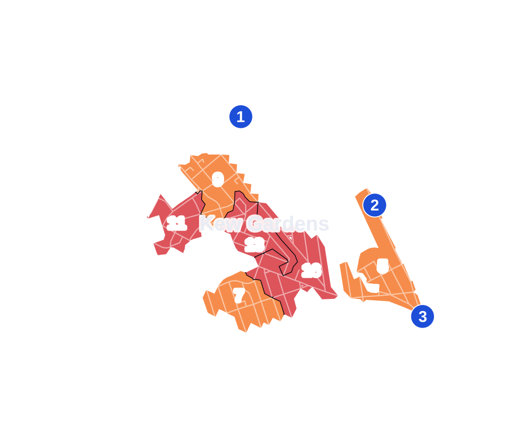
- 5 to 9
- 10 to 19
- 20 to 49
- 50 to 99
- 100 or more
- Not shaded: fewer than 5, held back under the rules in How complaints are counted, parks and public-housing grounds, and land in no patch
- Police precincts
- 102nd (most of the area), 107th
From January to June 2026 the NYPD recorded 71 major felonies at places in Kew Gardens, against 97 in the same months of 2025.
Sources: the NYPD's Complaint Data Historic, updated April 28, 2026, and Complaint Data Current (Year To Date), updated July 27, 2026, on NYC Open Data. Figures to June 30, 2026.
Street corners
- 80th Road & Grenfell Street
- 81st Avenue & Kew Gardens Road
- 82nd Avenue & Austin Street
- 82nd Avenue & Grenfell Street
- 82nd Avenue & Kew Gardens Road
- 83rd Avenue & Abingdon Road
- 83rd Avenue & Beverly Road
- 83rd Avenue & Grenfell Street
- 83rd Avenue & Kew Gardens Road
- 83rd Drive & Talbot Street
- 84th Avenue & 122nd Street
- 84th Avenue & Kew Gardens Road
- 84th Avenue & Talbot Street
- 85th Avenue & 118th Street
- 85th Avenue & 122nd Street
- 86th Road & Kew Gardens Road
- 87th Avenue & 135th Street
- 87th Avenue & 136th Street
- 87th Avenue & Kew Gardens Road
- 115th Street & 84th Avenue
- 115th Street & Park Lane South
- 116th Street & 84th Avenue
- 116th Street & Curzon Road
- 116th Street & Grosvenor Road
- 116th Street & Mayfair Road
- 117th Street & 84th Avenue
- 117th Street & Curzon Road
- 118th Street & 84th Avenue
- 118th Street & Curzon Road
- 120th Street & 84th Avenue
- 120th Street & 85th Avenue
- 121st Street & 84th Avenue
- 121st Street & 85th Avenue
- 123rd Street & 85th Avenue
- 124th Street & 85th Avenue
- 125th Street & 84th Drive
- 125th Street & 84th Road
- 125th Street & 85th Avenue
- 125th Street & Austin Street
- 126th Street & Austin Street
- 126th Street & Kew Gardens Road
- 127th Street & Austin Street
- 127th Street & Kew Gardens Road
- 129th Street & Kew Gardens Road
- 130th Street & Kew Gardens Road
- 131st Street & Kew Gardens Road
- 132nd Street & 82nd Avenue Pedestrian Overpass
- 132nd Street & Hoover Avenue
- 134th Street & 86th Road
- 134th Street & 87th Avenue
- 135th Street & 86th Road
- 136th Street & Kew Gardens Road
- Abingdon Road & 124th Place
- Abingdon Road & Brevoort Street
- Audley Street & Abingdon Road
- Audley Street & Grenfell Street
- Austin Street & 80th Road
- Austin Street & 81st Avenue
- Austin Street & 82nd Road
- Austin Street & 84th Drive
- Austin Street & 84th Road
- Austin Street & Mowbray Drive
- Beverly Road & Audley Street
- Beverly Road & Brevoort Street
- Cuthbert Road & 124th Place
- Cuthbert Road & Brevoort Street
- Forest Park Drive & Park Lane
- Grenfell Street & Onslow Place
- Hillside Avenue & 120th Street
- Hillside Avenue & 121st Street
- Hillside Avenue & 126th Street
- Hillside Avenue & 131st Street
- Hillside Avenue & 135th Street
- Hillside Avenue & 136th Street
- Hillside Avenue & Kew Gardens Road
- Hillside Avenue & Lefferts Boulevard
- Jackie Robinson Parkway & Metropolitan Avenue
- Jackie Robinson Parkway & Queens Boulevard
- Jackie Robinson Parkway & Van Wyck Expressway
- Kew Gardens Road & 80th Road
- Kew Gardens Road & 82nd Road
- Kew Gardens Road & 83rd Drive
- Kew Gardens Road & 84th Road
- Kew Gardens Road & Mowbray Drive
- Lefferts Boulevard & 83rd Avenue
- Lefferts Boulevard & 84th Avenue
- Lefferts Boulevard & 85th Avenue
- Lefferts Boulevard & Abingdon Road
- Lefferts Boulevard & Austin Street
- Lefferts Boulevard & Beverly Road
- Lefferts Boulevard & Cuthbert Road
- Lefferts Boulevard & Grenfell Street
- Lefferts Boulevard & Kew Gardens Road
- Lefferts Boulevard & Talbot Street
- Metropolitan Avenue & 85th Avenue
- Metropolitan Avenue & 116th Street
- Metropolitan Avenue & 118th Street
- Metropolitan Avenue & 123rd Street
- Metropolitan Avenue & 124th Place
- Metropolitan Avenue & 124th Street
- Metropolitan Avenue & 125th Street
- Metropolitan Avenue & 126th Street
- Metropolitan Avenue & 127th Street
- Metropolitan Avenue & 129th Street
- Metropolitan Avenue & Brevoort Street
- Metropolitan Avenue & Forest Park Drive
- Metropolitan Avenue & Grosvenor Lane
- Metropolitan Avenue & J Robinson Parkway
- Metropolitan Avenue & J Robinson Parkway at Jackie Robinson Parkway
- Metropolitan Avenue & Jackie Robinson Parkway
- Metropolitan Avenue & Lefferts Boulevard
- Metropolitan Avenue & Park Lane South
- Park Lane & 80th Road
- Park Lane South & Abingdon Road
- Park Lane South & Beverly Road
- Park Lane South & Curzon Road
- Park Lane South & Grosvenor Road
- Park Lane South & Mayfair Road
- Park Lane South & Park Lane
- Queens Boulevard & 80th Road
- Queens Boulevard & 82nd Avenue
- Queens Boulevard & 83rd Avenue
- Union Turnpike & 126th Street
- Union Turnpike & 132nd Street
- Union Turnpike & Grenfell Street
- Union Turnpike & Markwood Place
- Union Turnpike & Park Lane
- Union Turnpike & Van Wyck Expressway
- Union Turnpike & Van Wyck Expressway (Union Turnpike)
- Van Wyck Expressway & 87th Avenue
- Van Wyck Expressway & Grand Central Parkway
- Van Wyck Expressway & Hillside Avenue
- Van Wyck Expressway & Kew Gardens Road
- Van Wyck Expressway & Union Turnpike
- Van Wyck Expressway & Van Wyck Expressway/Hillside Avenue
How the figures above are measured: Methodology.