East Flatbush-Farragut
Neighborhood · Brooklyn
East Flatbush-Farragut is the central section of East Flatbush, lying south of Holy Cross Cemetery and Cortelyou Road, with Kings Highway to the east and the Bay Ridge Branch rail line along its southern edge.
- 0.87 square miles
- 34,317 residents, 2020 Census
- 126 street corners
- 1 subway station
- 10 bus routes
Once part of the colonial Town of Flatbush, it is named for David Farragut (1801-1870), the U.S. admiral whose Civil War service included the Battle of Mobile Bay. Before 1950 East Flatbush was home mostly to Jewish and Italian families, and since the 1960s, especially in the 1970s, many immigrants from the Caribbean have made their homes here, as they have in neighboring Flatbush and Crown Heights.
Sources: East Flatbush, Brooklyn (Wikipedia); David Farragut (Encyclopaedia Britannica).
East Flatbush-Farragut borders five areas, and Avenue D and Farragut Road hold more of its corners than any other street, 23 each of 126.
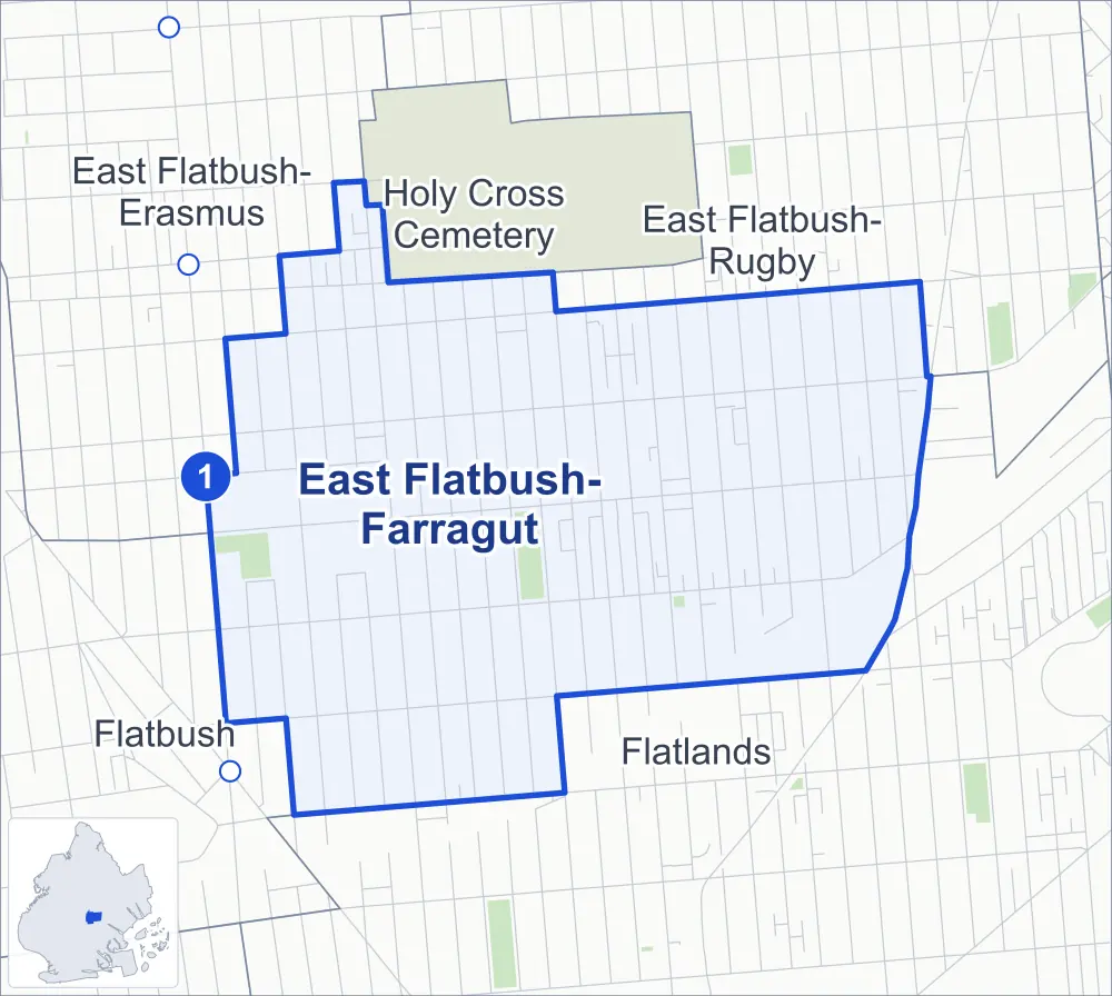
- East Flatbush-Farragut
- A neighboring area
- Park
- A station in the list
- Another station
Neighborhood areas and streets: NYC Department of City Planning. Parks: NYC Parks. Stations: MTA.
Neighboring areas
- East Flatbush-Rugby northeast
- Flatlands southeast
- Flatbush southwest
- East Flatbush-Erasmus northwest
- Holy Cross Cemetery northwest
Subway stations
- Newkirk Av-Little Haiti lines 2 5
Getting around
One subway station and buses on ten routes stop in or at the edge of East Flatbush-Farragut.
- 1 subway station
- 9 local bus routes
- 1 express bus route
Local bus routes
- B6
- B7
- B8
- B44
- B44-SBS
- B46
- B46-SBS
- B96
- B103
Express bus route
- BM2
Safety record
Between 2021 and 2025, its corners averaged more police-reported crashes than the average Brooklyn corner.
- 1,365 police-reported crashes at its corners
- 10.8 a corner, on average
- 10.5 the average Brooklyn corner
- 1 corner with a clean record
Signal or safety changes on City record, at 25 of its corners
- Accessible pedestrian signals
- 17
- Leading pedestrian intervals
- 16
- Safety Improvement Projects
- 2
- Turn calming
- 1
- Barnes Dance all-way crossings
- 1
Camera tickets
In 2025 its corners had more school-zone speed camera tickets than bus-lane or red-light tickets.
- 0 red-light camera tickets
- 5,439 school-zone speed camera tickets at 11 corners
- 1,165 bus-lane camera tickets at one corner
- Most speed tickets
- East 48th Street & Clarendon Road, 1,288
- Most bus-lane tickets
- Utica Avenue & Avenue D, 1,165
People and homes
The 2020 Census counted 34,317 residents in East Flatbush-Farragut, about 39,400 per square mile.
- 12,609 homes, 2020 Census
- 1,379 homes added since April 2010, net, by City Planning's count
Half of its 4,885 residential lots hold buildings from 1930 or earlier, and 76% of them date from before 1940, by the City's tax lot records.
Parks
- Parkland
- 6.8 acres of NYC Parks property
- The largest pieces
- Paerdegat Park (3.6 acres), Nostrand Playground (3.1 acres) and Chiarantano Playground (0.2 acre)
Streets and trees
- Trees
- 2,688 in NYC Parks' records, most often London planetree, pin oak and thornless honeylocust
- Street with the most corners
- Avenue D, with 23 of the area's 126
- Height above sea level
- From 9 feet at Kings Highway & East 53rd Street to 42 feet at East 35th Street & Tilden Avenue
- Honorary street names
- 4 at its corners, enacted by local law
Schools and libraries
The City lists ten schools and one library in East Flatbush-Farragut.
- Public schools
- 5
- Charter and private schools
- 5
- Library
- Clarendon Library
Bike share
By the station list of October 3, 2026, three bike-share stations stand in East Flatbush-Farragut.
- 3 bike-share stations
Public safety
How complaints are countedIn 2025 the NYPD recorded 358 major felonies at places in East Flatbush-Farragut.
Recorded by the NYPD at places in East Flatbush-Farragut
- 293 major felonies in 2024
- 1,342 other felonies, misdemeanors and violations in 2025
In 2025, on the streets along the edge of East Flatbush-Farragut, the NYPD recorded another 125 major felonies. Counting the streets along its edge, in 2025 the NYPD recorded 14.1 major felonies for every thousand residents the 2020 Census counted in East Flatbush-Farragut.
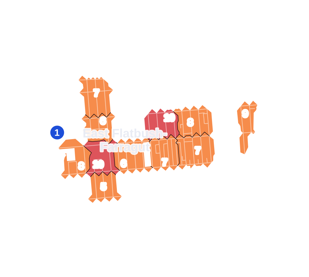
- 5 to 9
- 10 to 19
- 20 to 49
- 50 to 99
- 100 or more
- Not shaded: fewer than 5, held back under the rules in How complaints are counted, parks and public-housing grounds, and land in no patch
- Police precincts
- 67th (most of the area), 63rd
From January to June 2026 the NYPD recorded 138 major felonies at places in East Flatbush-Farragut, against 162 in the same months of 2025.
Sources: the NYPD's Complaint Data Historic, updated April 28, 2026, and Complaint Data Current (Year To Date), updated July 27, 2026, on NYC Open Data. Figures to June 30, 2026.
Street corners
- Albany Avenue & Avenue D
- Albany Avenue & Clarendon Road
- Albany Avenue & Cortelyou Road
- Albany Avenue & Farragut Road
- Avenue D & East 31st Street
- Avenue D & East 32nd Street
- Avenue D & East 39th Street
- Avenue D & East 40th Street
- Avenue D & East 42nd Street
- Avenue D & East 43rd Street
- Avenue D & East 45th Street
- Avenue D & East 46th Street
- Avenue D & East 48th Street
- Avenue D & East 49th Street
- Avenue D & East 51st Street
- Brooklyn Avenue & Avenue D
- Brooklyn Avenue & Beverley Road
- Brooklyn Avenue & Clarendon Road
- Brooklyn Avenue & Cortelyou Road
- Brooklyn Avenue & Farragut Road
- Brooklyn Avenue & Newkirk Avenue
- Brooklyn Avenue & Tilden Avenue
- Clarendon Road & East 39th Street
- Clarendon Road & East 42nd Street
- Cortelyou Road & East 39th Street
- East 31st Street & Farragut Place
- East 31st Street & Newkirk Avenue
- East 32nd Street & Avenue H
- East 32nd Street & Clarendon Road
- East 32nd Street & Farragut Place
- East 32nd Street & Newkirk Avenue
- East 34th Street & Avenue D
- East 34th Street & Beverley Road
- East 34th Street & Clarendon Road
- East 34th Street & Cortelyou Road
- East 34th Street & Newkirk Avenue
- East 35th Street & Avenue D
- East 35th Street & Avenue H
- East 35th Street & Clarendon Road
- East 35th Street & Cortelyou Road
- East 35th Street & Farragut Road
- East 35th Street & Glenwood Road
- East 35th Street & Newkirk Avenue
- East 35th Street & Tilden Avenue
- East 37th Street & Avenue D
- East 37th Street & Clarendon Road
- East 37th Street & Cortelyou Road
- East 38th Street & Avenue D
- East 38th Street & Avenue H
- East 38th Street & Clarendon Road
- East 38th Street & Cortelyou Road
- East 40th Street & Clarendon Road
- East 40th Street & Cortelyou Road
- East 46th Street & Clarendon Road
- East 48th Street & Clarendon Road
- East 51st Street & Clarendon Road
- East 52nd Street & Avenue D
- East 53rd Street & Avenue D
- East 54th Street & Clarendon Road
- Farragut Road & East 31st Street
- Farragut Road & East 32nd Street
- Farragut Road & East 34th Street
- Farragut Road & East 37th Street
- Farragut Road & East 38th Street
- Farragut Road & East 39th Street
- Farragut Road & East 40th Street
- Farragut Road & East 42nd Street
- Farragut Road & East 43rd Street
- Farragut Road & East 45th Street
- Farragut Road & East 46th Street
- Farragut Road & East 48th Street
- Farragut Road & East 49th Street
- Farragut Road & East 51st Street
- Farragut Road & East 52nd Street
- Foster Avenue & Albany Avenue
- Foster Avenue & Brooklyn Avenue
- Foster Avenue & East 37th Street
- Foster Avenue & East 38th Street
- Foster Avenue & East 39th Street
- Foster Avenue & East 40th Street
- Foster Avenue & East 42nd Street
- Foster Avenue & East 43rd Street
- Foster Avenue & East 45th Street
- Foster Avenue & East 46th Street
- Foster Avenue & East 48th Street
- Foster Avenue & East 49th Street
- Foster Avenue & East 51st Street
- Foster Avenue & East 52nd Street
- Foster Avenue & East 53rd Street
- Foster Avenue & New York Avenue
- Foster Avenue & Schenectady Avenue
- Foster Avenue & Troy Avenue
- Foster Avenue & Utica Avenue
- Glenwood Road & Albany Avenue
- Glenwood Road & Brooklyn Avenue
- Glenwood Road & East 31st Street
- Glenwood Road & East 32nd Street
- Glenwood Road & East 34th Street
- Glenwood Road & East 37th Street
- Glenwood Road & East 38th Street
- Glenwood Road & East 39th Street
- Glenwood Road & East 40th Street
- Glenwood Road & East 42nd Street
- Glenwood Road & East 43rd Street
- Glenwood Road & East 45th Street
- Glenwood Road & East 48th Street
- Glenwood Road & New York Avenue
- Glenwood Road & Troy Avenue
- Kings Highway & East 53rd Street
- Kings Highway & East 54th Street
- Kings Highway & Farragut Road
- Kings Highway & Foster Avenue
- New York Avenue & Avenue D
- New York Avenue & Avenue H
- New York Avenue & Cortelyou Road
- New York Avenue & Farragut Road
- New York Avenue & Newkirk Avenue
- Nostrand Avenue & Newkirk Avenue
- Schenectady Avenue & Avenue D
- Schenectady Avenue & Clarendon Road
- Schenectady Avenue & Farragut Road
- Troy Avenue & Avenue D
- Troy Avenue & Farragut Road
- Utica Avenue & Avenue D
- Utica Avenue & Clarendon Road
- Utica Avenue & Farragut Road
How the figures above are measured: Methodology.