East Flatbush-Erasmus
Neighborhood · Brooklyn
East Flatbush-Erasmus is the westernmost section of East Flatbush, beginning at Flatbush and Bedford Avenues, and its blocks around Nostrand and Church Avenues have been nicknamed Little Caribbean since 2017, a nod to the Caribbean immigrants who settled here from the 1960s on.
- 0.71 square miles
- 47,690 residents, 2020 Census
- 126 street corners
- 4 subway stations
- 10 bus routes
In the courtyard of Erasmus Hall High School stands a Federal-style wooden building of 1786, where Erasmus Hall started out in 1787 as a private academy funded in part by John Jay, Alexander Hamilton and Aaron Burr. It was the first secondary school chartered by the New York State Regents. Nearby on Snyder Avenue is the Victorian Gothic Flatbush Town Hall, completed in 1875.
Sources: East Flatbush, Brooklyn (Wikipedia); Erasmus Hall Museum (LP-0171) (NYC Landmarks Preservation Commission); Flatbush Town Hall (LP-0770) (NYC Landmarks Preservation Commission).
East Flatbush-Erasmus borders five areas, and Rogers Avenue holds more of its corners than any other street, 15 of 126.
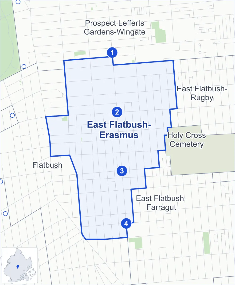
- East Flatbush-Erasmus
- A neighboring area
- Park
- A station in the list
- Another station
Neighborhood areas and streets: NYC Department of City Planning. Parks: NYC Parks. Stations: MTA.
Neighboring areas
- Prospect Lefferts Gardens-Wingate north
- East Flatbush-Rugby northeast
- Holy Cross Cemetery east
- East Flatbush-Farragut southeast
- Flatbush southwest
Subway stations
- Winthrop St lines 2 5
- Church Av lines 2 5 accessible
- Beverly Rd lines 2 5
- Newkirk Av-Little Haiti lines 2 5
Getting around
Four subway stations and buses on ten routes stop in or at the edge of East Flatbush-Erasmus.
- 4 subway stations
- 1 of them listed by the MTA as fully accessible
- 9 local bus routes
- 1 express bus route
Local bus routes
- B8
- B12
- B35
- B41
- B44
- B44-SBS
- B49
- B96
- B103
Express bus route
- BM2
Safety record
Between 2021 and 2025, its corners averaged more police-reported crashes than the average Brooklyn corner.
- 1,742 police-reported crashes at its corners
- 13.8 a corner, on average
- 10.5 the average Brooklyn corner
- 5 corners with a clean record
Signal or safety changes on City record, at 53 of its corners
- Leading pedestrian intervals
- 50
- Accessible pedestrian signals
- 17
- Turn calming
- 10
- Barnes Dance all-way crossings
- 3
- Safety Improvement Projects
- 2
Camera tickets
In 2025 its corners had more bus-lane camera tickets than school-zone speed or red-light tickets.
- 0 red-light camera tickets
- 10,430 school-zone speed camera tickets at eight corners
- 35,028 bus-lane camera tickets at five corners
- Most speed tickets
- Nostrand Avenue & Tilden Avenue, 2,627
- Most bus-lane tickets
- Linden Boulevard & Rogers Avenue, 11,430
People and homes
The 2020 Census counted 47,690 residents in East Flatbush-Erasmus, about 67,200 per square mile.
- 19,105 homes, 2020 Census
- 5,222 homes added since April 2010, net, by City Planning's count
Half of its 3,448 residential lots hold buildings from 1920 or earlier, and 88% of them date from before 1940, by the City's tax lot records.
Landmarks
- Designated landmarks
- The Flatbush Town Hall, the Flatbush District No. 1 School, the Erasmus Hall Academy and the Erasmus Hall High School
- Historic district
- East 25th Street Historic District, wholly or partly within East Flatbush-Erasmus
Streets and trees
- Trees
- 2,458 in NYC Parks' records, most often London planetree, thornless honeylocust and littleleaf linden
- Street with the most corners
- Rogers Avenue, with 15 of the area's 126
- Height above sea level
- From 20 feet at Avenue D & Rogers Avenue to 58 feet at Bedford Avenue & Parkside Avenue
- Honorary street name
- 1 at its corners, enacted by local law
Schools
The City lists 16 schools in East Flatbush-Erasmus.
- Public schools
- 9
- Charter and private schools
- 7
Bike share
By the station list of October 3, 2026, 16 bike-share stations stand in East Flatbush-Erasmus.
- 16 bike-share stations
Public safety
How complaints are countedIn 2025 the NYPD recorded 599 major felonies at places in East Flatbush-Erasmus.
Recorded by the NYPD at places in East Flatbush-Erasmus
- 561 major felonies in 2024
- 2,555 other felonies, misdemeanors and violations in 2025
In 2025, on the streets along the edge of East Flatbush-Erasmus, the NYPD recorded another 195 major felonies. Counting the streets along its edge, in 2025 the NYPD recorded 16.6 major felonies for every thousand residents the 2020 Census counted in East Flatbush-Erasmus.
- Police precincts
- 67th (most of the area), 71st, 70th
From January to June 2026 the NYPD recorded 228 major felonies at places in East Flatbush-Erasmus, against 290 in the same months of 2025.
Sources: the NYPD's Complaint Data Historic, updated April 28, 2026, and Complaint Data Current (Year To Date), updated July 27, 2026, on NYC Open Data. Figures to June 30, 2026.
Street corners
- Albemarle Road & Lott Street
- Albemarle Road & Oakland Place
- Albemarle Road & Veronica Place
- Avenue D & East 25th Street
- Avenue D & Rogers Avenue
- Bedford Avenue & Albemarle Road
- Bedford Avenue & Beverley Road
- Bedford Avenue & Caton Avenue
- Bedford Avenue & Church Avenue
- Bedford Avenue & Cortelyou Road
- Bedford Avenue & Erasmus Street
- Bedford Avenue & Parkside Avenue
- Bedford Avenue & Snyder Avenue
- Bedford Avenue & Tilden Avenue
- Beverley Road & Lott Street
- Beverley Road & Veronica Place
- Brooklyn Avenue & Lenox Road
- Brooklyn Avenue & Snyder Avenue
- Church Avenue & Brooklyn Avenue
- Church Avenue & East 31st Street
- Church Avenue & East 32nd Street
- Church Avenue & East 34th Street
- Church Avenue & East 37th Street
- Church Avenue & Lloyd Street
- Church Avenue & Rogers Avenue
- Church Avenue & Veronica Place
- Church Avenue & Woods Place
- Clarendon Road & East 25th Street
- Clarkson Avenue & Rogers Avenue
- Cortelyou Road & East 25th Street
- Cortelyou Road & Lott Street
- Cortelyou Road & Veronica Place
- East 22nd Street & Tilden Avenue
- East 26th Street & Avenue D
- East 26th Street & Clarendon Road
- East 26th Street & Cortelyou Road
- East 26th Street & Newkirk Avenue
- East 28th Street & Albemarle Road
- East 28th Street & Avenue D
- East 28th Street & Beverley Road
- East 28th Street & Clarendon Road
- East 28th Street & Cortelyou Road
- East 28th Street & Newkirk Avenue
- East 28th Street & Tilden Avenue
- East 29th Street & Albemarle Road
- East 29th Street & Avenue D
- East 29th Street & Beverley Road
- East 29th Street & Clarendon Road
- East 29th Street & Cortelyou Road
- East 29th Street & Newkirk Avenue
- East 29th Street & Tilden Avenue
- East 31st Street & Beverley Road
- East 31st Street & Clarendon Road
- East 31st Street & Cortelyou Road
- East 31st Street & Snyder Avenue
- East 31st Street & Tilden Avenue
- East 32nd Street & Beverley Road
- East 32nd Street & Cortelyou Road
- East 32nd Street & Snyder Avenue
- East 32nd Street & Tilden Avenue
- East 34th Street & Lenox Road
- East 34th Street & Snyder Avenue
- East 34th Street & Tilden Avenue
- East 35th Street & Beverley Road
- East 35th Street & Church Avenue
- East 35th Street & Lenox Road
- East 35th Street & Snyder Avenue
- East 37th Street & Clarkson Avenue
- East 37th Street & Lenox Road
- East 37th Street & Snyder Avenue
- Erasmus Street & Lloyd Street
- Erasmus Street & Woods Place
- Flatbush Avenue & Albemarle Road
- Flatbush Avenue & Bedford Avenue
- Foster Avenue & East 26th Street
- Foster Avenue & East 28th Street
- Foster Avenue & East 29th Street
- Foster Avenue & Rogers Avenue
- Linden Boulevard & Brooklyn Avenue
- Linden Boulevard & East 34th Street
- Linden Boulevard & East 35th Street
- Linden Boulevard & East 37th Street
- Linden Boulevard & East 38th Street
- Linden Boulevard & New York Avenue
- Linden Boulevard & Rogers Avenue
- Lott Street & Erasmus Street
- Martense Street & Fairview Place
- Martense Street & Raleigh Place
- New York Avenue & Beverley Road
- New York Avenue & Church Avenue
- New York Avenue & Clarendon Road
- New York Avenue & Clarkson Avenue
- New York Avenue & Lenox Road
- New York Avenue & Martense Street
- New York Avenue & Snyder Avenue
- New York Avenue & Tilden Avenue
- Newkirk Avenue & East 25th Street
- Nostrand Avenue & Albemarle Road
- Nostrand Avenue & Avenue D
- Nostrand Avenue & Beverley Road
- Nostrand Avenue & Church Avenue
- Nostrand Avenue & Clarendon Road
- Nostrand Avenue & Cortelyou Road
- Nostrand Avenue & Erasmus Street
- Nostrand Avenue & Lenox Road
- Nostrand Avenue & Linden Boulevard
- Nostrand Avenue & Martense Street
- Nostrand Avenue & Snyder Avenue
- Nostrand Avenue & Tilden Avenue
- Rogers Avenue & Albemarle Road
- Rogers Avenue & Beverley Road
- Rogers Avenue & Clarendon Road
- Rogers Avenue & Cortelyou Road
- Rogers Avenue & Erasmus Street
- Rogers Avenue & Lenox Road
- Rogers Avenue & Martense Street
- Rogers Avenue & Newkirk Avenue
- Rogers Avenue & Snyder Avenue
- Rogers Avenue & Tilden Avenue
- Snyder Avenue & Lott Street
- Snyder Avenue & Veronica Place
- Snyder Avenue & Woods Place
- Tilden Avenue & Lott Street
- Tilden Avenue & Oakland Place
- Tilden Avenue & Veronica Place
- Veronica Place & Erasmus Street
How the figures above are measured: Methodology.