Prospect Lefferts Gardens-Wingate
Neighborhood · Brooklyn
East of Prospect Park, Prospect Lefferts Gardens extends from Empire Boulevard to Clarkson Avenue between Ocean and New York Avenues, and Wingate continues east to Troy Avenue.
- 0.86 square miles
- 49,513 residents, 2020 Census
- 125 street corners
- 4 subway stations
- 14 bus routes
In 1893 James Lefferts split his family's estate into 600 lots, now Lefferts Manor, with deed rules requiring single-family brick or stone houses of at least two stories, and the manor became a city historic district in 1979; the family's 18th-century farmhouse was moved into Prospect Park in 1918. The name Prospect Lefferts Gardens, coined in 1968, combines Prospect Park, Lefferts Manor and the Brooklyn Botanic Garden, while Wingate takes its name from Wingate Park and a former high school.
Sources: Prospect Lefferts Gardens, Brooklyn (Wikipedia); Lefferts Historic House (Prospect Park Alliance); Wingate, Brooklyn (Wikipedia).
Prospect Lefferts Gardens-Wingate borders five areas, and Maple Street holds more of its corners than any other street, 15 of 125.
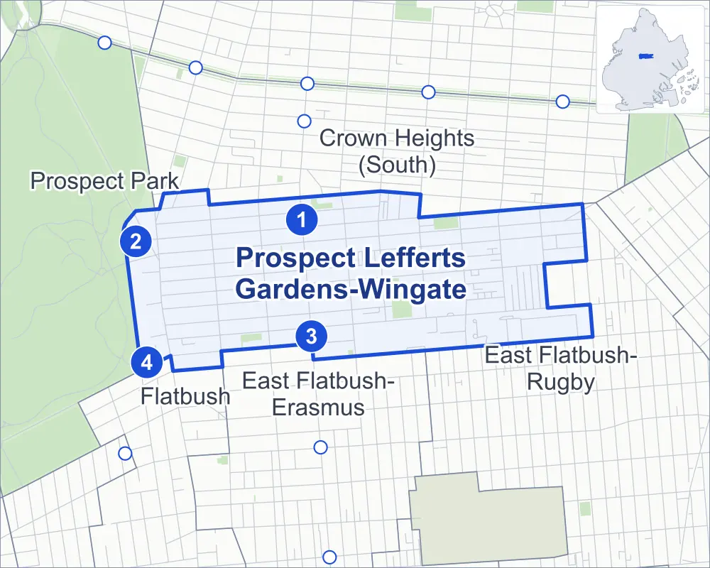
- Prospect Lefferts Gardens-Wingate
- A neighboring area
- Park
- A station in the list
- Another station
Neighborhood areas and streets: NYC Department of City Planning. Parks: NYC Parks. Stations: MTA.
Neighboring areas
- Crown Heights (South) north
- East Flatbush-Rugby east
- East Flatbush-Erasmus south
- Flatbush southwest
- Prospect Park west
Subway stations
- Sterling St lines 2 5
- Prospect Park lines B Q S accessible
- Winthrop St lines 2 5
- Parkside Av lines Q
Getting around
Four subway stations and buses on 14 routes stop in or at the edge of Prospect Lefferts Gardens-Wingate.
- 4 subway stations
- 1 of them listed by the MTA as fully accessible
- 14 local bus routes
Local bus routes
- B12
- B16
- B17
- B41
- B43
- B44
- B44-SBS
- B46
- B46-SBS
- B48
- B49
- B96
- B116
- T464
Safety record
Between 2021 and 2025, its corners averaged more police-reported crashes than the average Brooklyn corner.
- 1,801 police-reported crashes at its corners
- 14.4 a corner, on average
- 10.5 the average Brooklyn corner
- 7 corners with a clean record
Signal or safety changes on City record, at 63 of its corners
- Leading pedestrian intervals
- 53
- Accessible pedestrian signals
- 23
- Turn calming
- 10
- Safety Improvement Projects
- 4
- Barnes Dance all-way crossings
- 3
Camera tickets
In 2025 its corners had more school-zone speed camera tickets than bus-lane or red-light tickets.
- 0 red-light camera tickets
- 28,125 school-zone speed camera tickets at 12 corners
- 3,543 bus-lane camera tickets at two corners
- Most speed tickets
- Flatbush Avenue & Ocean Avenue, 19,210
- Most bus-lane tickets
- Utica Avenue & Rutland Road, 3,274
People and homes
The 2020 Census counted 49,513 residents in Prospect Lefferts Gardens-Wingate, about 57,600 per square mile.
- 21,109 homes, 2020 Census
- 3,347 homes added since April 2010, net, by City Planning's count
Half of its 3,579 residential lots hold buildings from 1920 or earlier, and 79% of them date from before 1940, by the City's tax lot records.
Parks and landmarks
- Parkland
- 10.8 acres of NYC Parks property
- The largest pieces
- Wingate Park (5.7 acres), Hamilton Metz Field (2.3 acres) and Winthrop Playground (1.3 acres)
- Historic districts
- Chester Court, Melrose Parkside, Ocean on the Park and Prospect Lefferts Gardens, wholly or partly within Prospect Lefferts Gardens-Wingate
Streets and trees
- Trees
- 3,071 in NYC Parks' records, most often London planetree, pin oak and thornless honeylocust
- Street with the most corners
- Maple Street, with 15 of the area's 125
- Height above sea level
- From 29 feet at Troy Avenue & Rutland Road to 83 feet at Flatbush Avenue & Ocean Avenue
- Honorary street names
- 6 at its corners, enacted by local law
Schools and libraries
The City lists 25 schools and one library in Prospect Lefferts Gardens-Wingate.
- Public schools
- 12
- Charter and private schools
- 13
- Library
- Crown Heights Library
Bike share
By the station list of October 3, 2026, 30 bike-share stations stand in Prospect Lefferts Gardens-Wingate.
- 30 bike-share stations
Public safety
How complaints are countedIn 2025 the NYPD recorded 422 major felonies at places in Prospect Lefferts Gardens-Wingate.
Recorded by the NYPD at places in Prospect Lefferts Gardens-Wingate
- 288 major felonies in 2024
- 1,785 other felonies, misdemeanors and violations in 2025
In 2025, on the streets along the edge of Prospect Lefferts Gardens-Wingate, the NYPD recorded another 227 major felonies. Counting the streets along its edge, in 2025 the NYPD recorded 13.1 major felonies for every thousand residents the 2020 Census counted in Prospect Lefferts Gardens-Wingate.
- Police precinct
- 71st
From January to June 2026 the NYPD recorded 194 major felonies at places in Prospect Lefferts Gardens-Wingate, against 188 in the same months of 2025.
Sources: the NYPD's Complaint Data Historic, updated April 28, 2026, and Complaint Data Current (Year To Date), updated July 27, 2026, on NYC Open Data. Figures to June 30, 2026.
Street corners
- Albany Avenue & Clarkson Avenue
- Albany Avenue & East New York Avenue
- Albany Avenue & Fenimore Street
- Albany Avenue & Hawthorne Street
- Albany Avenue & Lefferts Avenue
- Albany Avenue & Maple Street
- Albany Avenue & Midwood Street
- Albany Avenue & Rutland Road
- Albany Avenue & Winthrop Street
- Bedford Avenue & Fenimore Street
- Bedford Avenue & Hawthorne Street
- Bedford Avenue & Lefferts Avenue
- Bedford Avenue & Lincoln Road
- Bedford Avenue & Maple Street
- Bedford Avenue & Midwood Street
- Bedford Avenue & Rutland Road
- Bedford Avenue & Sterling Street
- Bedford Avenue & Winthrop Street
- Brooklyn Avenue & East New York Avenue
- Brooklyn Avenue & Fenimore Street
- Brooklyn Avenue & Hawthorne Street
- Brooklyn Avenue & Lefferts Avenue
- Brooklyn Avenue & Maple Street
- Brooklyn Avenue & Midwood Street
- Brooklyn Avenue & Rutland Road
- Brooklyn Avenue & Sterling Street
- Brooklyn Avenue & Winthrop Street
- Clarkson Avenue & East 45th Street
- Clarkson Avenue & East 46th Street
- East 45th Street & Rutland Road
- East 48th Street & Maple Street
- East 48th Street & Midwood Street
- East 49th Street & Winthrop Street
- East New York Avenue & Kingston Avenue
- Empire Boulevard & Clove Road
- Empire Boulevard & Lamont Court
- Empire Boulevard & McKeever Place
- Flatbush Avenue & Beekman Place
- Flatbush Avenue & Chester Court
- Flatbush Avenue & Clarkson Avenue
- Flatbush Avenue & Fenimore Street
- Flatbush Avenue & Hawthorne Street
- Flatbush Avenue & Lefferts Avenue
- Flatbush Avenue & Lincoln Road
- Flatbush Avenue & Maple Street
- Flatbush Avenue & Midwood Street
- Flatbush Avenue & Ocean Avenue
- Flatbush Avenue & Rutland Road
- Flatbush Avenue & Washington Avenue
- Flatbush Avenue & Westbury Court
- Flatbush Avenue & Winthrop Street
- Franklin Avenue & Empire Boulevard
- Kingston Avenue & Lefferts Avenue
- Kingston Avenue & Maple Street
- Kingston Avenue & Midwood Street
- Lefferts Avenue & Balfour Place
- Lefferts Avenue & Lamont Court
- Maple Street & Miami Court
- Maple Street & Palm Court
- Maple Street & Tampa Court
- Midwood Street & Miami Court
- Midwood Street & Palm Court
- Midwood Street & Tampa Court
- New York Avenue & East New York Avenue
- New York Avenue & Fenimore Street
- New York Avenue & Hawthorne Street
- New York Avenue & Lefferts Avenue
- New York Avenue & Maple Street
- New York Avenue & Midwood Street
- New York Avenue & Rutland Road
- New York Avenue & Sterling Street
- New York Avenue & Winthrop Street
- Nostrand Avenue & Clarkson Avenue
- Nostrand Avenue & Fenimore Street
- Nostrand Avenue & Hawthorne Street
- Nostrand Avenue & Lefferts Avenue
- Nostrand Avenue & Lincoln Road
- Nostrand Avenue & Maple Street
- Nostrand Avenue & Midwood Street
- Nostrand Avenue & Parkside Avenue
- Nostrand Avenue & Rutland Road
- Nostrand Avenue & Sterling Street
- Nostrand Avenue & Winthrop Street
- Ocean Avenue & Lincoln Road
- Ocean Avenue & Parkside Avenue
- Parkside Avenue & New York Avenue
- Parkside Avenue & Rogers Avenue
- Rogers Avenue & Fenimore Street
- Rogers Avenue & Hawthorne Street
- Rogers Avenue & Lefferts Avenue
- Rogers Avenue & Lincoln Road
- Rogers Avenue & Maple Street
- Rogers Avenue & Midwood Street
- Rogers Avenue & Rutland Road
- Rogers Avenue & Sterling Street
- Rogers Avenue & Winthrop Street
- Rutland Road & East 46th Street
- Rutland Road & Kingston Avenue
- Schenectady Avenue & Clarkson Avenue
- Schenectady Avenue & East New York Avenue
- Schenectady Avenue & Lefferts Avenue
- Schenectady Avenue & Maple Street
- Schenectady Avenue & Midwood Street
- Schenectady Avenue & Rutland Road
- Schenectady Avenue & Winthrop Street
- Sullivan Place & McKeever Place
- Troy Avenue & East New York Avenue
- Troy Avenue & Fenimore Street
- Troy Avenue & Hawthorne Street
- Troy Avenue & Kingsboro Psychiatric Center Driveway
- Troy Avenue & Lefferts Avenue
- Troy Avenue & Maple Street
- Troy Avenue & Midwood Street
- Troy Avenue & Rutland Road
- Troy Avenue & Winthrop Street
- Utica Avenue & Empire Boulevard
- Utica Avenue & Maple Street
- Utica Avenue & Rutland Road
- Washington Avenue & Empire Boulevard
- Washington Avenue & Franklin Avenue
- Washington Avenue & Lefferts Avenue
- Washington Avenue & Sterling Street
- Winthrop Street & East 45th Street
- Winthrop Street & East 46th Street
- Winthrop Street & Kingston Avenue
How the figures above are measured: Methodology.