Flatlands
Neighborhood · Brooklyn
Flatlands fills a stretch of southeastern Brooklyn just below the Bay Ridge Branch rail line.
- 1.95 square miles
- 67,087 residents, 2020 Census
- 332 street corners
- 20 bus routes
It began in 1636 as the Dutch farming settlement of Nieuw Amersfoort, when Wolfert Gerritse Van Couwenhoven and Andries Hudde acquired 15,000 acres around what is now the meeting of Kings Highway and Flatbush Avenue, and it joined the City of Brooklyn in 1896. The Greek Revival Flatlands Reformed Church of 1848, at Kings Highway and East 40th Street, follows two earlier churches, the first dedicated in 1663. On East 34th Street, the Coe House is a Dutch Colonial farmhouse completed in 1793-94.
Sources: Flatlands, Brooklyn (Wikipedia); Flatlands Reformed Church (LP-0177) (NYC Landmarks Preservation Commission); Coe House (LP-0176) (NYC Landmarks Preservation Commission).
Flatlands borders seven areas, and Avenue J and Avenue M hold more of its corners than any other street, 33 each of 332.
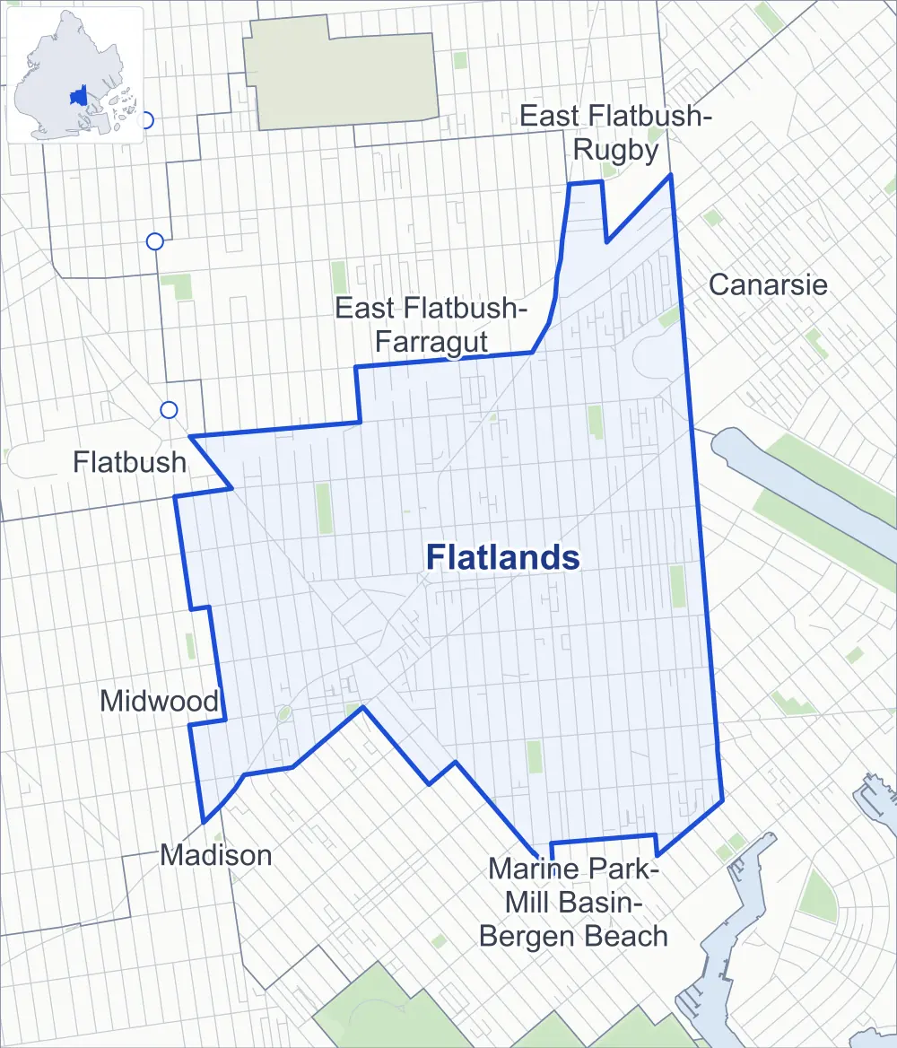
- Flatlands
- A neighboring area
- Park
- Another station
Neighborhood areas and streets: NYC Department of City Planning. Parks: NYC Parks. Stations: MTA.
Neighboring areas
- East Flatbush-Farragut north
- East Flatbush-Rugby north
- Canarsie northeast
- Marine Park-Mill Basin-Bergen Beach south
- Madison southwest
- Midwood west
- Flatbush west
Getting around
Buses on 20 routes stop in or at the edge of Flatlands.
- 17 local bus routes
- 3 express bus routes
Local bus routes
- B2
- B6
- B7
- B8
- B9
- B11
- B41
- B44
- B44-SBS
- B46
- B46-SBS
- B47
- B82
- B82-SBS
- B100
- B103
- Q35
Express bus routes
- BM1
- BM2
- BM4
Safety record
Between 2021 and 2025, its corners averaged fewer police-reported crashes than the average Brooklyn corner.
- 2,789 police-reported crashes at its corners
- 8.4 a corner, on average
- 10.5 the average Brooklyn corner
- 18 corners with a clean record
Signal or safety changes on City record, at 83 of its corners
- Accessible pedestrian signals
- 52
- Leading pedestrian intervals
- 41
- Turn calming
- 9
- Barnes Dance all-way crossings
- 3
- Safety Improvement Projects
- 2
Camera tickets
In 2025 its corners had more school-zone speed camera tickets than bus-lane or red-light tickets.
- 548 red-light camera tickets at two corners
- 76,431 school-zone speed camera tickets at 35 corners
- 3,249 bus-lane camera tickets at three corners
- Most red-light tickets
- Avenue J & New York Avenue, 289
- Most speed tickets
- Kings Highway & Avenue J, 9,487
- Most bus-lane tickets
- Avenue L & Utica Avenue, 1,490
People and homes
The 2020 Census counted 67,087 residents in Flatlands, about 34,400 per square mile.
- 23,740 homes, 2020 Census
- 153 homes added since April 2010, net, by City Planning's count
Half of its 10,843 residential lots hold buildings from 1930 or earlier, and 62% of them date from before 1940, by the City's tax lot records.
NYCHA development
NYCHA's Glenwood development lies wholly or partly within Flatlands.
Parks and landmarks
- Parkland
- 14 acres of NYC Parks property
- The largest pieces
- Amersfort Park (3.5 acres), Jacob Joffe Fields (2.9 acres) and Fox Playground (2.3 acres)
- Designated landmarks
- The Flatlands Dutch Reformed Church Sunday School, the Flatlands Dutch Reformed Church and the Joost and Elizabeth Van Nuyse House
Streets and trees
- Trees
- 5,728 in NYC Parks' records, most often London planetree, pin oak and Japanese zelkova
- Street with the most corners
- Avenue J, with 33 of the area's 332
- Height above sea level
- From 8 feet at East 57th Street & Avenue O to 34 feet at Albany Avenue & Avenue H
- Honorary street names
- 13 at its corners, enacted by local law
Schools and libraries
The City lists seven schools and two libraries in Flatlands.
- Public schools
- 3
- Charter and private schools
- 4
- Libraries
- Flatlands Library and Paerdegat Library
Public safety
How complaints are countedIn 2025 the NYPD recorded 486 major felonies at places in Flatlands.
Recorded by the NYPD at places in Flatlands
- 524 major felonies in 2024
- 2,224 other felonies, misdemeanors and violations in 2025
In 2025, on the streets along the edge of Flatlands, the NYPD recorded another 189 major felonies. Counting the streets along its edge, in 2025 the NYPD recorded 10.1 major felonies for every thousand residents the 2020 Census counted in Flatlands.
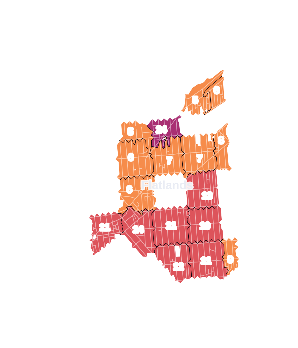
- 5 to 9
- 10 to 19
- 20 to 49
- 50 to 99
- 100 or more
- Not shaded: fewer than 5, held back under the rules in How complaints are counted, parks and public-housing grounds, and land in no patch
- Police precincts
- 63rd (most of the area), 67th, 70th
From January to June 2026 the NYPD recorded 241 major felonies at places in Flatlands, against 233 in the same months of 2025.
Sources: the NYPD's Complaint Data Historic, updated April 28, 2026, and Complaint Data Current (Year To Date), updated July 27, 2026, on NYC Open Data. Figures to June 30, 2026.
Street corners
- Albany Avenue & Avenue H
- Albany Avenue & Avenue I
- Albany Avenue & East 40th Street
- Avenue D & East 55th Street
- Avenue H & East 39th Street
- Avenue H & East 42nd Street
- Avenue H & East 43rd Street
- Avenue H & East 46th Street
- Avenue H & Paerdegat Avenue South
- Avenue I & East 31st Street
- Avenue I & East 32nd Street
- Avenue I & East 39th Street
- Avenue I & East 40th Street
- Avenue I & East 42nd Street
- Avenue I & East 43rd Street
- Avenue I & East 45th Street
- Avenue I & East 46th Street
- Avenue I & East 48th Street
- Avenue I & East 54th Street
- Avenue J & Albany Avenue
- Avenue J & Brooklyn Avenue
- Avenue J & East 31st Street
- Avenue J & East 32nd Street
- Avenue J & East 34th Street
- Avenue J & East 35th Street
- Avenue J & East 37th Street
- Avenue J & East 38th Street
- Avenue J & East 39th Street
- Avenue J & East 40th Street
- Avenue J & East 42nd Street
- Avenue J & East 43rd Street
- Avenue J & East 46th Street
- Avenue J & East 48th Street
- Avenue J & East 49th Street
- Avenue J & East 51st Street
- Avenue J & East 52nd Street
- Avenue J & East 53rd Street
- Avenue J & East 54th Street
- Avenue J & East 55th Street
- Avenue J & East 56th Street
- Avenue J & East 57th Street
- Avenue J & East 58th Street
- Avenue J & East 59th Street
- Avenue J & New York Avenue
- Avenue J & Ralph Avenue
- Avenue J & Schenectady Avenue
- Avenue J & Troy Avenue
- Avenue K & Albany Avenue
- Avenue K & East 31st Street
- Avenue K & East 32nd Street
- Avenue K & East 34th Street
- Avenue K & East 35th Street
- Avenue K & East 36th Street
- Avenue K & East 37th Street
- Avenue K & East 38th Street
- Avenue K & East 39th Street
- Avenue K & East 40th Street
- Avenue K & East 42nd Street
- Avenue K & East 43rd Street
- Avenue K & East 45th Street
- Avenue K & East 46th Street
- Avenue K & East 48th Street
- Avenue K & East 49th Street
- Avenue K & East 51st Street
- Avenue K & East 52nd Street
- Avenue K & East 53rd Street
- Avenue K & East 54th Street
- Avenue K & East 55th Street
- Avenue K & East 56th Street
- Avenue K & East 57th Street
- Avenue K & East 58th Street
- Avenue K & East 59th Street
- Avenue K & New York Avenue
- Avenue K & Schenectady Avenue
- Avenue K & Troy Avenue
- Avenue K & Utica Avenue
- Avenue L & East 31st Street
- Avenue L & East 32nd Street
- Avenue L & East 34th Street
- Avenue L & East 35th Street
- Avenue L & East 36th Street
- Avenue L & East 37th Street
- Avenue L & East 38th Street
- Avenue L & East 41st Street
- Avenue L & East 46th Street
- Avenue L & East 48th Street
- Avenue L & East 49th Street
- Avenue L & East 51st Street
- Avenue L & East 52nd Street
- Avenue L & East 53rd Street
- Avenue L & East 54th Street
- Avenue L & East 55th Street
- Avenue L & East 56th Street
- Avenue L & East 57th Street
- Avenue L & East 58th Street
- Avenue L & East 59th Street
- Avenue L & New York Avenue
- Avenue L & Schenectady Avenue
- Avenue L & Troy Avenue
- Avenue L & Utica Avenue
- Avenue M & East 29th Street
- Avenue M & East 31st Street
- Avenue M & East 32nd Street
- Avenue M & East 34th Street
- Avenue M & East 36th Street
- Avenue M & East 37th Street
- Avenue M & East 38th Street
- Avenue M & East 43rd Street
- Avenue M & East 45th Street
- Avenue M & East 46th Street
- Avenue M & East 48th Street
- Avenue M & East 49th Street
- Avenue M & East 51st Street
- Avenue M & East 52nd Street
- Avenue M & East 53rd Street
- Avenue M & East 54th Street
- Avenue M & East 55th Street
- Avenue M & East 56th Street
- Avenue M & East 57th Street
- Avenue M & East 58th Street
- Avenue M & East 59th Street
- Avenue M & Harden Street
- Avenue M & New York Avenue
- Avenue M & Ralph Avenue
- Avenue M & Ralph Avenue at East 65th Street
- Avenue M & Ryder Street
- Avenue M & Schenectady Avenue
- Avenue M & Troy Avenue
- Avenue M & Utica Avenue
- Avenue N & East 31st Street
- Avenue N & East 34th Street
- Avenue N & East 35th Street
- Avenue N & East 45th Street
- Avenue N & East 46th Street
- Avenue N & East 48th Street
- Avenue N & East 49th Street
- Avenue N & East 51st Street
- Avenue N & East 52nd Street
- Avenue N & East 53rd Street
- Avenue N & East 54th Street
- Avenue N & East 55th Street
- Avenue N & East 56th Street
- Avenue N & East 57th Street
- Avenue N & East 58th Street
- Avenue N & East 59th Street
- Avenue N & Schenectady Avenue
- Avenue N & Utica Avenue
- Avenue O & East 58th Street
- Avenue O & East 59th Street
- Avenue P & Coleman Street
- Avenue P & Hendrickson Street
- Avenue T & East 58th Street
- Avenue T & East 59th Street
- Avenue T & Pearson Street
- Brooklyn Avenue & Avenue H
- Brooklyn Avenue & Avenue I
- East 34th Street & Avenue H
- East 34th Street & Avenue I
- East 35th Street & Avenue I
- East 37th Street & Avenue H
- East 37th Street & Avenue I
- East 38th Street & Avenue I
- East 39th Street & Hubbard Place
- East 40th Street & Alton Place
- East 40th Street & Avenue H
- East 40th Street & Hubbard Place
- East 40th Street & Lott Place
- East 45th Street & Avenue H
- East 45th Street & Glendale Court
- East 48th Street & Avenue H
- East 48th Street & Avenue O
- East 49th Street & Avenue H
- East 49th Street & Avenue I
- East 49th Street & Avenue O
- East 49th Street & Fillmore Avenue
- East 51st Street & Avenue H
- East 51st Street & Avenue I
- East 51st Street & Avenue O
- East 51st Street & Fillmore Avenue
- East 52nd Street & Avenue H
- East 52nd Street & Avenue I
- East 52nd Street & Avenue O
- East 52nd Street & Fillmore Avenue
- East 53rd Street & Avenue H
- East 53rd Street & Avenue I
- East 53rd Street & Avenue O
- East 53rd Street & Preston Court
- East 54th Street & Avenue H
- East 54th Street & Avenue O
- East 54th Street & Fillmore Avenue
- East 55th Street & Avenue H
- East 55th Street & Avenue I
- East 55th Street & Avenue O
- East 55th Street & Mill Lane
- East 56th Street & Avenue D
- East 56th Street & Avenue H
- East 56th Street & Avenue I
- East 56th Street & Avenue O
- East 56th Street & Fillmore Avenue
- East 56th Street & Mill Lane
- East 56th Street & Preston Court
- East 56th Street & Whitty Lane
- East 57th Street & Avenue H
- East 57th Street & Avenue I
- East 57th Street & Avenue O
- East 57th Street & Fillmore Avenue
- East 59th Street & Mill Lane
- East 59th Street & Paerdegat Avenue South
- Farragut Road & East 57th Street
- Farragut Road & East 58th Street
- Farragut Road & East 59th Street
- Flatbush Avenue & Alton Place
- Flatbush Avenue & Aurelia Court
- Flatbush Avenue & Avenue I
- Flatbush Avenue & Avenue J
- Flatbush Avenue & Avenue K
- Flatbush Avenue & Avenue L
- Flatbush Avenue & Avenue M
- Flatbush Avenue & Avenue N
- Flatbush Avenue & Avenue O
- Flatbush Avenue & Avenue P
- Flatbush Avenue & Baughman Place
- Flatbush Avenue & Brooklyn Avenue
- Flatbush Avenue & East 34th Street
- Flatbush Avenue & East 35th Street
- Flatbush Avenue & East 36th Street
- Flatbush Avenue & East 37th Street
- Flatbush Avenue & East 38th Street
- Flatbush Avenue & East 46th Street
- Flatbush Avenue & East 48th Street
- Flatbush Avenue & Fillmore Avenue
- Flatbush Avenue & Flatlands Avenue
- Flatbush Avenue & Kings Highway
- Flatbush Avenue & Lott Place
- Flatbush Avenue & New York Avenue
- Flatbush Avenue & Schenectady Avenue
- Flatbush Avenue & Troy Avenue
- Flatlands Avenue & Avenue I
- Flatlands Avenue & Avenue J
- Flatlands Avenue & Avenue K
- Flatlands Avenue & Avenue L
- Flatlands Avenue & Avenue M
- Flatlands Avenue & Avenue N
- Flatlands Avenue & East 40th Street
- Flatlands Avenue & East 43rd Street
- Flatlands Avenue & East 46th Street
- Flatlands Avenue & East 48th Street
- Flatlands Avenue & East 49th Street
- Flatlands Avenue & East 51st Street
- Flatlands Avenue & East 52nd Street
- Flatlands Avenue & East 53rd Street
- Flatlands Avenue & East 54th Street
- Flatlands Avenue & East 55th Street
- Flatlands Avenue & East 56th Street
- Flatlands Avenue & East 57th Street
- Flatlands Avenue & East 59th Street
- Flatlands Avenue & Harden Street
- Flatlands Avenue & Hendrickson Street
- Flatlands Avenue & Lotts Lane
- Flatlands Avenue & Ryder Street
- Flatlands Avenue & Ryder Street at Coleman Street
- Flatlands Avenue & Schenectady Avenue
- Flatlands Avenue & Troy Avenue
- Flatlands Avenue & Utica Avenue
- Foster Avenue & East 53rd Street
- Foster Avenue & East 54th Street
- Foster Avenue & East 55th Street
- Foster Avenue & East 56th Street
- Foster Avenue & East 57th Street
- Foster Avenue & East 58th Street
- Foster Avenue & East 59th Street
- Glenwood Road & Avenue H
- Glenwood Road & East 46th Street
- Glenwood Road & East 49th Street
- Glenwood Road & East 52nd Street
- Glenwood Road & East 53rd Street
- Glenwood Road & East 54th Street
- Glenwood Road & East 55th Street
- Glenwood Road & East 56th Street
- Glenwood Road & East 56th Street at Farragut Road
- Glenwood Road & East 59th Street
- Glenwood Road & Paerdegat Avenue South
- Glenwood Road & Schenectady Avenue
- Harden Street & Lott Place
- Kings Highway & Avenue D
- Kings Highway & Avenue H
- Kings Highway & Avenue I
- Kings Highway & Avenue J
- Kings Highway & Avenue K
- Kings Highway & Avenue M
- Kings Highway & East 35th Street
- Kings Highway & East 36th Street
- Kings Highway & East 37th Street
- Kings Highway & East 38th Street
- Kings Highway & East 40th Street
- Kings Highway & East 41st Street
- Kings Highway & Foster Avenue
- Kings Highway & Glenwood Road
- Kings Highway & New York Avenue
- Kings Highway & Ryder Street
- Kings Highway & Schenectady Avenue
- Kings Highway & Troy Avenue
- Kings Highway & Utica Avenue
- Nostrand Avenue & Avenue I
- Nostrand Avenue & Avenue J
- Nostrand Avenue & Avenue M
- Nostrand Avenue & Avenue N
- Quentin Road & Hendrickson Street
- Ralph Avenue & Bergen Avenue
- Ralph Avenue & Chase Court
- Ralph Avenue & East 64th Street
- Ralph Avenue & East 72nd Street
- Ralph Avenue & East 77th Street
- Ralph Avenue & East 78th Street
- Ralph Avenue & East 80th Street
- Ralph Avenue & East 80th Street at Preston Court
- Ralph Avenue & Farragut Road
- Ralph Avenue & Glenwood Road
- Ralph Avenue & Paerdegat Avenue South
- Schenectady Avenue & Avenue H
- Schenectady Avenue & Avenue I
- Schenectady Avenue & Avenue O
- Schenectady Avenue & Glendale Court
- Troy Avenue & Avenue H
- Troy Avenue & Avenue I
- Troy Avenue & Baughman Place
- Troy Avenue & East 41st Street
- Utica Avenue & Avenue H
- Utica Avenue & Avenue I
- Utica Avenue & Avenue J
- Utica Avenue & Avenue O
- Utica Avenue & Glenwood Road
How the figures above are measured: Methodology.