Spring Creek-Starrett City
Neighborhood · Brooklyn
On the Jamaica Bay side of East New York, south of Flatlands Avenue, Spring Creek is named for one of several creeks that once drained this former salt marsh into the bay.
- 0.97 square miles
- 17,038 residents, 2020 Census
- 61 street corners
- 10 bus routes
It includes Starrett City, 46 apartment buildings of up to 20 stories begun in 1972 under the Mitchell-Lama housing program and renamed Spring Creek Towers in 2002, with its own power plant and two public schools. A shopping complex opened in 2002 and modular rowhouses followed from 2008, and the old landfills by the bay became the 407-acre Shirley Chisholm State Park, which opened in 2019 with 10 miles of trails.
Sources: Spring Creek, Brooklyn (Wikipedia); Starrett City (Wikipedia); Starrett City history (Brooklyn Daily Eagle); Shirley Chisholm State Park (New York State Parks).
Spring Creek-Starrett City borders four areas, and Vandalia Avenue holds more of its corners than any other street, 15 of 61.
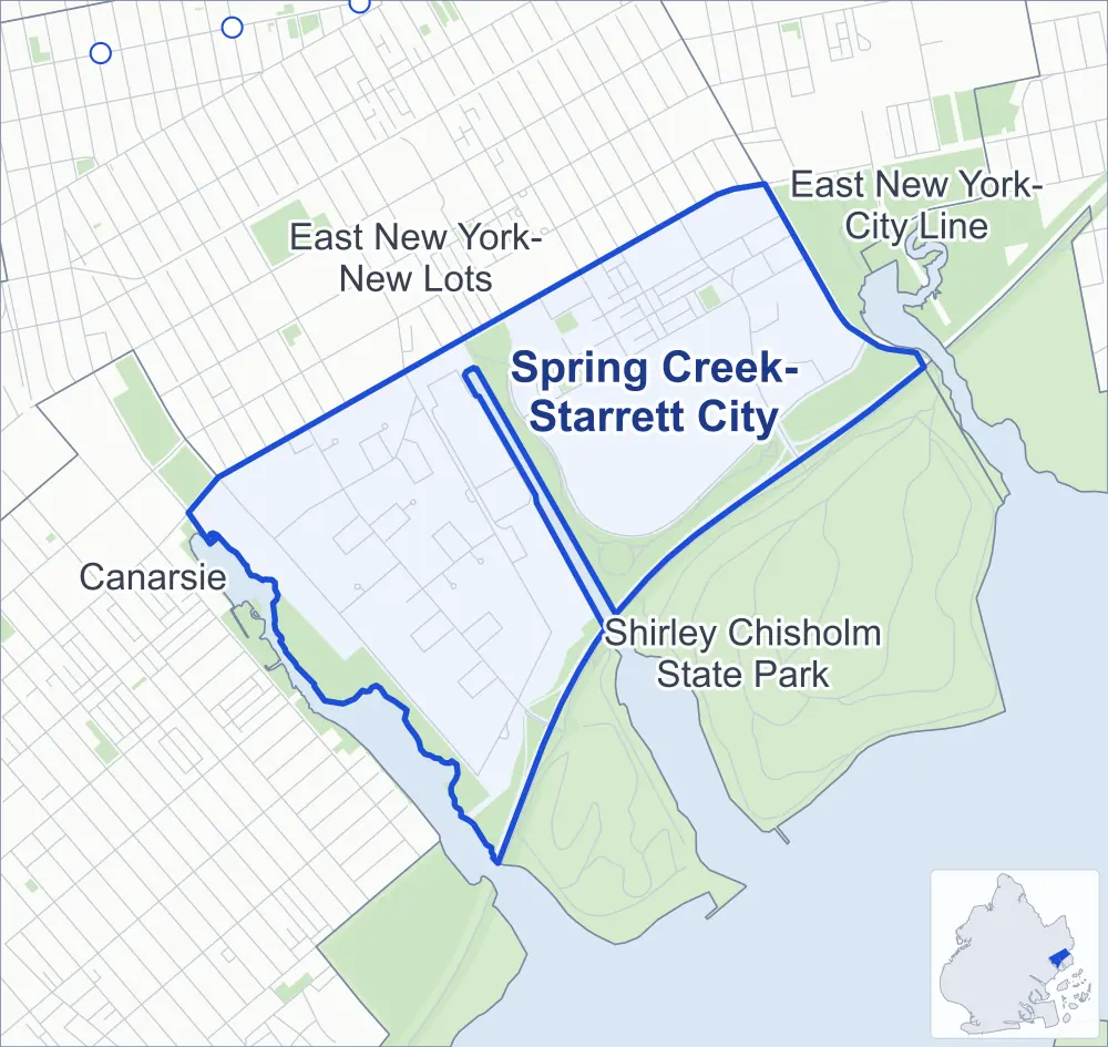
- Spring Creek-Starrett City
- A neighboring area
- Park
- Another station
Neighborhood areas and streets: NYC Department of City Planning. Parks: NYC Parks. Stations: MTA.
Neighboring areas
- East New York-New Lots north
- East New York-City Line northeast
- Shirley Chisholm State Park southeast
- Canarsie west
Getting around
Buses on ten routes stop in or at the edge of Spring Creek-Starrett City.
- 8 local bus routes
- 2 express bus routes
Local bus routes
- B13
- B60
- B82
- B82-SBS
- B83
- B84
- B103
- Q8
Express bus routes
- BM2
- BM5
Safety record
Between 2021 and 2025, its corners averaged more police-reported crashes than the average Brooklyn corner.
- 663 police-reported crashes at its corners
- 10.9 a corner, on average
- 10.5 the average Brooklyn corner
- 14 corners with a clean record
Signal or safety changes on City record, at ten of its corners
- Leading pedestrian intervals
- 6
- Accessible pedestrian signals
- 2
- Turn calming
- 2
- Barnes Dance all-way crossings
- 2
- Safety Improvement Projects
- 1
Camera tickets
In 2025 its corners had more school-zone speed camera tickets than bus-lane or red-light tickets.
- 1,604 red-light camera tickets at one corner
- 18,515 school-zone speed camera tickets at four corners
- 2,198 bus-lane camera tickets at one corner
- Most red-light tickets
- Pennsylvania Avenue & Seaview Avenue, 1,604
- Most speed tickets
- Pennsylvania Avenue & Hornell Loop, 8,055
- Most bus-lane tickets
- Pennsylvania Avenue & Schroeders Avenue, 2,198
People and homes
The 2020 Census counted 17,038 residents in Spring Creek-Starrett City, about 17,600 per square mile.
- 8,251 homes, 2020 Census
- 4,347 homes added since April 2010, net, by City Planning's count
Half of its 566 residential lots hold buildings from 2011 or earlier, by the City's tax lot records.
NYCHA development
One NYCHA development, which NYCHA names by a building's address, lies wholly or partly within Spring Creek-Starrett City.
Parks
- Parkland
- 72.7 acres of NYC Parks property
- The largest pieces
- Spring Creek Park (42.4 acres), Fresh Creek Nature Preserve (25.7 acres) and Spring Creek Park (2.2 acres)
Streets and trees
- Trees
- 2,289 in NYC Parks' records, most often thornless honeylocust, London planetree and pin oak
- Street with the most corners
- Vandalia Avenue, with 15 of the area's 61
- Height above sea level
- From 10 feet at Flatlands Avenue & Georgia Avenue to 24 feet at Erskine Street & Belt Parkway
- Honorary street name
- 1 at its corners, enacted by local law
Schools
The City lists six schools in Spring Creek-Starrett City.
- Public schools
- 4
- Charter and private schools
- 2
Public safety
How complaints are countedIn 2025 the NYPD recorded 377 major felonies at places in Spring Creek-Starrett City.
Recorded by the NYPD at places in Spring Creek-Starrett City
- 391 major felonies in 2024
- 1,500 other felonies, misdemeanors and violations in 2025
In 2025, on the streets along the edge of Spring Creek-Starrett City, the NYPD recorded another 63 major felonies.
- Police precinct
- 75th
From January to June 2026 the NYPD recorded 145 major felonies at places in Spring Creek-Starrett City, against 162 in the same months of 2025.
Sources: the NYPD's Complaint Data Historic, updated April 28, 2026, and Complaint Data Current (Year To Date), updated July 27, 2026, on NYC Open Data. Figures to June 30, 2026.
Street corners
- Ashford Street & Schroeders Avenue
- Ashford Street & Vandalia Avenue
- Belt Parkway & Erskine Street
- Belt Parkway & Pennsylvania Avenue
- Berriman Street & Schroeders Avenue
- Berriman Street & Vandalia Avenue
- Elton Street & Egan Street
- Elton Street & Locke Street
- Elton Street & Schroeders Avenue
- Elton Street & Vandalia Avenue
- Erskine Street & Alafia Lane
- Erskine Street & Belt Parkway
- Erskine Street & Egan Street
- Erskine Street & Schroeders Avenue
- Erskine Street & Vital Avenue
- Essex Street & Egan Street
- Essex Street & Schroeders Avenue
- Essex Street & Vandalia Avenue
- Flatlands Avenue & Alabama Avenue
- Flatlands Avenue & Atkins Avenue
- Flatlands Avenue & Berriman Street
- Flatlands Avenue & Elton Street
- Flatlands Avenue & Georgia Avenue
- Flatlands Avenue & Jerome Street
- Flatlands Avenue & Milford Street
- Flatlands Avenue & Montauk Avenue
- Flatlands Avenue & Pennsylvania Avenue
- Flatlands Avenue & Van Siclen Avenue
- Fountain Avenue & Vandalia Avenue
- Gateway Drive & Schroeders Avenue
- Gateway Drive & Vandalia Avenue
- Jerome Street & Schroeders Avenue
- Jerome Street & Vandalia Avenue
- Linwood Street & Egan Street
- Louisiana Avenue & Twin Pines Drive
- Louisiana Avenue & Vandalia Avenue
- Milford Street & Egan Street
- Milford Street & Vandalia Avenue
- Pennsylvania Avenue & Croton Loop
- Pennsylvania Avenue & Delmar Loop
- Pennsylvania Avenue & Freeport Loop
- Pennsylvania Avenue & Geneva Loop
- Pennsylvania Avenue & Hornell Loop
- Pennsylvania Avenue & Schroeders Avenue
- Pennsylvania Avenue & Seaview Avenue
- Pennsylvania Avenue & Twin Pines Drive
- Pennsylvania Avenue & Vandalia Avenue
- Schroeders Avenue & Elmira Loop
- Schroeders Avenue & Walker Street
- Seaview Avenue & Field Drive
- Seaview Avenue & Fountain Avenue
- Seaview Avenue & Gateway Drive
- Seaview Avenue & Jughandle
- Seaview Avenue & Van Siclen Avenue
- Van Siclen Avenue & 26 Ward WWTP Driveway
- Van Siclen Avenue & Schroeders Avenue
- Van Siclen Avenue & Vandalia Avenue
- Vandalia Avenue & Ardsley Loop
- Vandalia Avenue & Bethel Loop
- Vandalia Avenue & Erskine Street
- Vandalia Avenue & Schroeders Walk
How the figures above are measured: Methodology.