Coney Island-Sea Gate
Neighborhood · Brooklyn
At the western end of Coney Island in southwestern Brooklyn, Coney Island-Sea Gate runs from the rides by the Riegelmann Boardwalk to Sea Gate, a private gated community at the tip with the 75-foot Coney Island Light of 1890.
- 1.71 square miles
- 49,517 residents, 2020 Census
- 194 street corners
- 4 subway stations
- 12 bus routes
Once the westernmost barrier island off Long Island's south shore, Coney Island got its first hotel in 1829, and Steeplechase Park, Luna Park and Dreamland opened between 1897 and 1904. From about 1880 to World War II it was the country's largest amusement area, and two rides from that era are city landmarks: the 150-foot Wonder Wheel, completed in 1920, and the 1927 Cyclone roller coaster.
Sources: Coney Island (Wikipedia); Sea Gate, Brooklyn (Wikipedia); Wonder Wheel (LP-1708) (NYC Landmarks Preservation Commission); The Cyclone (LP-1636) (NYC Landmarks Preservation Commission).
Coney Island-Sea Gate borders three areas, and Surf Avenue holds more of its corners than any other street, 46 of 194.
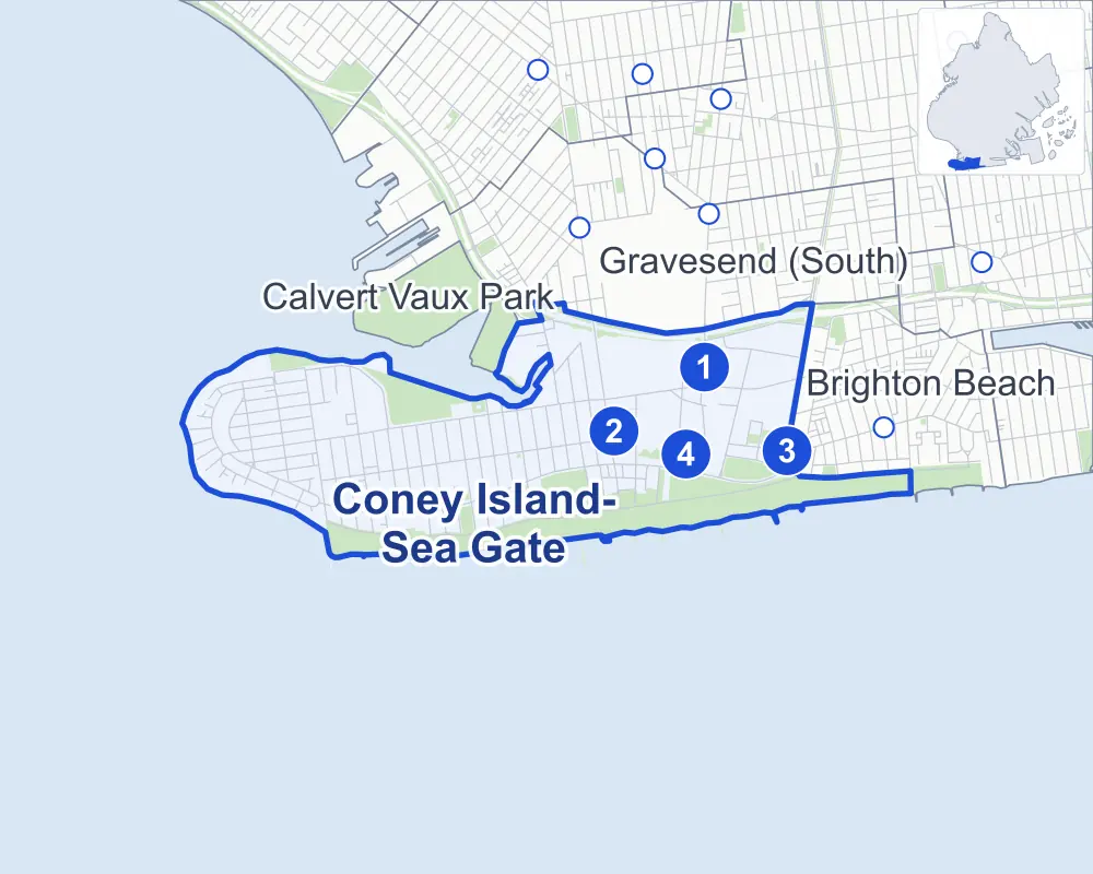
- Coney Island-Sea Gate
- A neighboring area
- Park
- A station in the list
- Another station
Neighborhood areas and streets: NYC Department of City Planning. Parks: NYC Parks. Stations: MTA.
Neighboring areas
- Calvert Vaux Park north
- Gravesend (South) northeast
- Brighton Beach east
Subway stations
- Neptune Av lines F
- Coney Island-Stillwell Av lines D F N Q accessible
- Ocean Pkwy lines Q
- W 8 St-NY Aquarium lines F Q
Getting around
Four subway stations and buses on 12 routes stop in or at the edge of Coney Island-Sea Gate.
- 4 subway stations
- 1 of them listed by the MTA as fully accessible
- 10 local bus routes
- 2 express bus routes
Local bus routes
- B1
- B4
- B36
- B64
- B68
- B74
- B82
- B90
- B102
- T464
Express bus routes
- X28
- X38
Safety record
Between 2021 and 2025, its corners averaged fewer police-reported crashes than the average Brooklyn corner.
- 1,812 police-reported crashes at its corners
- 9.3 a corner, on average
- 10.5 the average Brooklyn corner
- 62 corners with a clean record
Signal or safety changes on City record, at 48 of its corners
- Leading pedestrian intervals
- 42
- Accessible pedestrian signals
- 12
- Safety Improvement Projects
- 4
- Barnes Dance all-way crossings
- 3
- Turn calming
- 2
Camera tickets
In 2025 its corners had more school-zone speed camera tickets than red-light or bus-lane tickets.
- 1,588 red-light camera tickets at two corners
- 27,872 school-zone speed camera tickets at 14 corners
- 0 bus-lane camera tickets
- Most red-light tickets
- Surf Avenue & West 5th Street, 1,586
- Most speed tickets
- Cropsey Avenue & Hart Place, 7,871
People and homes
The 2020 Census counted 49,517 residents in Coney Island-Sea Gate, about 29,000 per square mile.
- 21,867 homes, 2020 Census
- 3,727 homes added since April 2010, net, by City Planning's count
Half of its 2,275 residential lots hold buildings from 1968 or earlier, and 36% of them date from before 1940, by the City's tax lot records.
NYCHA developments
NYCHA's Carey Gardens, Coney Island, Coney Island I (Site 1B), Coney Island I (Site 8), Coney Island I (Sites 4 & 5), Gravesend, Haber, O'Dwyer Gardens and Surfside Gardens developments lie wholly or partly within Coney Island-Sea Gate.
Parks and landmarks
- Parkland
- 226.5 acres of NYC Parks property
- The largest pieces
- Coney Island Beach & Boardwalk (147.8 acres), Kaiser Park (25.9 acres) and Asser Levy Park (21 acres)
- Designated landmarks
- The Child's Restaurant Building, the Shore Theater, the Wonder Wheel and the Cyclone, among others
Streets and trees
- Trees
- 3,401 in NYC Parks' records, most often thornless honeylocust, London planetree and common hackberry
- Street with the most corners
- Surf Avenue, with 46 of the area's 194
- Height above sea level
- From 3 feet at Mermaid Avenue & West 21st Street to 21 feet at Cropsey Avenue & Bay 52nd Street
- Honorary street names
- 25 at its corners, enacted by local law
Schools and libraries
The City lists 14 schools and one library in Coney Island-Sea Gate.
- Public schools
- 12
- Charter and private schools
- 2
- Library
- Coney Island Library
Public art
The City's public art inventory lists three works in Coney Island-Sea Gate: First Symphony of the Sea (1993), Brooklyn Wall of Remembrance (2002) and Jackie Robinson and Pee Wee Reese Monument (2005).
- 3 works of public art
Public safety
How complaints are countedIn 2025 the NYPD recorded 635 major felonies at places in Coney Island-Sea Gate.
Recorded by the NYPD at places in Coney Island-Sea Gate
- 581 major felonies in 2024
- 3,315 other felonies, misdemeanors and violations in 2025
In 2025, on the streets along the edge of Coney Island-Sea Gate, the NYPD recorded another 56 major felonies. Counting the streets along its edge, in 2025 the NYPD recorded 14.0 major felonies for every thousand residents the 2020 Census counted in Coney Island-Sea Gate.
- Police precinct
- 60th
From January to June 2026 the NYPD recorded 305 major felonies at places in Coney Island-Sea Gate, against 288 in the same months of 2025.
Sources: the NYPD's Complaint Data Historic, updated April 28, 2026, and Complaint Data Current (Year To Date), updated July 27, 2026, on NYC Open Data. Figures to June 30, 2026.
Street corners
- Atlantic Avenue & Beach 37th Street
- Atlantic Avenue & Beach 38th Street
- Atlantic Avenue & Beach 40th Street
- Atlantic Avenue & Beach 42nd Street
- Atlantic Avenue & Beach 43rd Street
- Atlantic Avenue & Beach 44th Street
- Atlantic Avenue & Beach 45th Street
- Atlantic Avenue & Surf Avenue
- Atlantic Avenue & Surf Avenue at West 37th Street
- Avenue Z & West 17th Street
- Bay 52nd Street & Belt Parkway
- Bay View Avenue & Sea Gate Avenue
- Bay View Avenue & West 35th Street
- Bay View Avenue & West 36th Street
- Bay View Avenue & West 37th Street
- Beach 49th Street & Sunset Court
- Belt Parkway & Ocean Parkway
- Belt Parkway & Shell Road
- Belt Parkway & Stillwell Avenue
- Boardwalk West & Boardwalk East
- Bowery & Henderson Walk
- Bowery & Jones Walk
- Bowery & Schweikerts Walk
- Brighton 1st Road & Boardwalk East
- Brighton 4th Street & Boardwalk East
- Cropsey Avenue & Bay 52nd Street
- Cropsey Avenue & Bay 53rd Street
- Cropsey Avenue & Bay 54th Street
- Cropsey Avenue & Canal Avenue
- Cropsey Avenue & Hart Place
- Highland Avenue & Cypress Avenue
- Highland Avenue & Laurel Avenue
- Highland Avenue & Lyme Avenue
- Highland Avenue & Maple Avenue
- Highland Avenue & Nautilus Avenue
- Manhattan Avenue & Cypress Avenue
- Manhattan Avenue & Highland Avenue
- Manhattan Avenue & Laurel Avenue
- Manhattan Avenue & Lyme Avenue
- Manhattan Avenue & Maple Avenue
- Manhattan Avenue & Neptune Avenue
- Mermaid Avenue & West 15th Street
- Mermaid Avenue & West 16th Street
- Mermaid Avenue & West 17th Street
- Mermaid Avenue & West 19th Street
- Mermaid Avenue & West 20th Street
- Mermaid Avenue & West 21st Street
- Mermaid Avenue & West 22nd Street
- Mermaid Avenue & West 23rd Street
- Mermaid Avenue & West 24th Street
- Mermaid Avenue & West 25th Street
- Mermaid Avenue & West 27th Street
- Mermaid Avenue & West 28th Street
- Mermaid Avenue & West 29th Street
- Mermaid Avenue & West 30th Street
- Mermaid Avenue & West 31st Street
- Mermaid Avenue & West 32nd Street
- Mermaid Avenue & West 33rd Street
- Mermaid Avenue & West 35th Street
- Mermaid Avenue & West 36th Street
- Mermaid Avenue & West 37th Street
- Nautilus Avenue & Tudor Terrace
- Neptune Avenue & Bay View Avenue
- Neptune Avenue & Cropsey Avenue
- Neptune Avenue & Highland Avenue
- Neptune Avenue & Sea Gate Avenue
- Neptune Avenue & Sheepshead Bay Road
- Neptune Avenue & West 5th Street
- Neptune Avenue & West 6th Street
- Neptune Avenue & West 8th Street
- Neptune Avenue & West 12th Street
- Neptune Avenue & West 15th Street
- Neptune Avenue & West 16th Street
- Neptune Avenue & West 19th Street
- Neptune Avenue & West 20th Street
- Neptune Avenue & West 21st Street
- Neptune Avenue & West 22nd Street
- Neptune Avenue & West 23rd Street
- Neptune Avenue & West 24th Street
- Neptune Avenue & West 25th Street
- Neptune Avenue & West 28th Street
- Neptune Avenue & West 30th Street
- Neptune Avenue & West 32nd Street
- Neptune Avenue & West 33rd Street
- Neptune Avenue & West 35th Street
- Neptune Avenue & West 36th Street
- Neptune Avenue & West 37th Street
- Ocean Parkway & Neptune Avenue
- Ocean View Avenue & Beach 51st Street
- Ocean View Avenue & Highland Avenue
- Oceanic Avenue & Tudor Terrace
- Sea Gate Avenue & Cypress Avenue
- Sea Gate Avenue & Laurel Avenue
- Sea Gate Avenue & Lyme Avenue
- Sea Gate Avenue & Maple Avenue
- Sea Gate Avenue & Nautilus Avenue
- Sea Gate Avenue & Oceanic Avenue
- Sea Gate Avenue & Poplar Avenue
- Shore Parkway & Bay 52nd Street (east)
- Shore Parkway & Bay 52nd Street (west)
- Shore Parkway & Belt Parkway
- Shore Parkway & Belt Parkway (Exit 7)
- Shore Parkway & Stillwell Avenue
- Shore Parkway & West 2nd Street
- Shore Parkway & West 6th Street
- Shore Parkway & West 22nd Street
- Shore Parkway & West 22nd Street at Bay 52nd Street
- Shore Parkway & West Avenue
- Shore Parkway & West Street
- Stillwell Avenue & Boardwalk West
- Stillwell Avenue & Bowery
- Stillwell Avenue & Mermaid Avenue
- Stillwell Avenue & Neptune Avenue
- Stillwell Avenue & Wonder Wheel Way
- Stillwell Avenue Bridge & Stillwell Avenue
- Surf Avenue & Beach 38th Street
- Surf Avenue & Beach 40th Street
- Surf Avenue & Beach 46th Street
- Surf Avenue & Beach 47th Street
- Surf Avenue & Beach 48th Street
- Surf Avenue & Beach 49th Street
- Surf Avenue & Beach 50th Street
- Surf Avenue & Beach 51st Street
- Surf Avenue & Henderson Walk
- Surf Avenue & Highland Avenue
- Surf Avenue & Highland Avenue at Beach 42nd Street
- Surf Avenue & Highland Avenue at Poplar Avenue
- Surf Avenue & Jones Walk
- Surf Avenue & Mermaid Avenue
- Surf Avenue & Nautilus Avenue
- Surf Avenue & Neptune Avenue
- Surf Avenue & Neptune Avenue at Beach 45th Street
- Surf Avenue & Ocean Parkway
- Surf Avenue & Oceanic Avenue
- Surf Avenue & Schweikerts Walk
- Surf Avenue & Stillwell Avenue
- Surf Avenue & West 5th Street
- Surf Avenue & West 8th Street
- Surf Avenue & West 10th Street
- Surf Avenue & West 12th Street
- Surf Avenue & West 15th Street
- Surf Avenue & West 16th Street
- Surf Avenue & West 17th Street
- Surf Avenue & West 19th Street
- Surf Avenue & West 20th Street
- Surf Avenue & West 21st Street
- Surf Avenue & West 22nd Street
- Surf Avenue & West 23rd Street
- Surf Avenue & West 24th Street
- Surf Avenue & West 25th Street
- Surf Avenue & West 27th Street
- Surf Avenue & West 28th Street
- Surf Avenue & West 29th Street
- Surf Avenue & West 30th Street
- Surf Avenue & West 31st Street
- Surf Avenue & West 32nd Street
- Surf Avenue & West 33rd Street
- Surf Avenue & West 35th Street
- Surf Avenue & West 36th Street
- West 1st Street & Sea Breeze Avenue
- West 1st Street & West Brighton Avenue
- West 2nd Street & Sea Breeze Avenue
- West 2nd Street & West Brighton Avenue
- West 3rd Street & West 2nd Place
- West 3rd Street & West Brighton Avenue
- West 5th Street & Sea Breeze Avenue
- West 5th Street & West Avenue
- West 5th Street & West Brighton Avenue
- West 6th Street & Sheepshead Bay Road
- West 8th Street & Sheepshead Bay Road
- West 10th Street & Boardwalk West
- West 12th Street & Bowery
- West 12th Street & Wonder Wheel Way
- West 15th Street & Boardwalk West
- West 15th Street & Bowery
- West 15th Street & Hart Place
- West 16th Street & Boardwalk West
- West 16th Street & Hart Place
- West 17th Street & Bay 52nd Street
- West 21st Street & Boardwalk West
- West 23rd Street & Boardwalk West
- West 24th Street & Boardwalk West
- West 25th Street & Boardwalk West
- West 27th Street & Boardwalk West
- West 28th Street & Boardwalk West
- West 29th Street & Boardwalk West
- West 32nd Street & Sea Place
- West 33rd Street & Bay View Avenue
- West 33rd Street & Boardwalk West
- West 35th Street & Boardwalk West
- West 36th Street & Boardwalk West
- West 36th Street & Canal Avenue
- West 37th Street & Canal Avenue
- West 37th Street & Polar Street
How the figures above are measured: Methodology.