Brighton Beach
Neighborhood · Brooklyn
On Brooklyn's Atlantic shore, Brighton Beach lies between Coney Island at Ocean Parkway and Manhattan Beach at Corbin Place, with its beach and boardwalk to the south and the Belt Parkway to the north.
- 0.49 square miles
- 33,568 residents, 2020 Census
- 170 street corners
- 2 subway stations
- 8 bus routes
Henry C. Murphy and a group of businessmen named the resort in 1878 after the English seaside city of Brighton. Once the Brighton Line began running as a subway in 1920, thirty apartment buildings rose between 1921 and 1929 and the area became a densely built residential neighborhood. From the mid-1970s tens of thousands of Jewish emigres from the Soviet Union settled here, earning it the nickname Little Odessa.
Sources: Brighton Beach (Wikipedia); Brighton Beach (Brooklyn Jewish Historical Initiative).
Brighton Beach borders three areas, and Brighton Beach Avenue and Ocean View Avenue hold more of its corners than any other street, 20 each of 170.
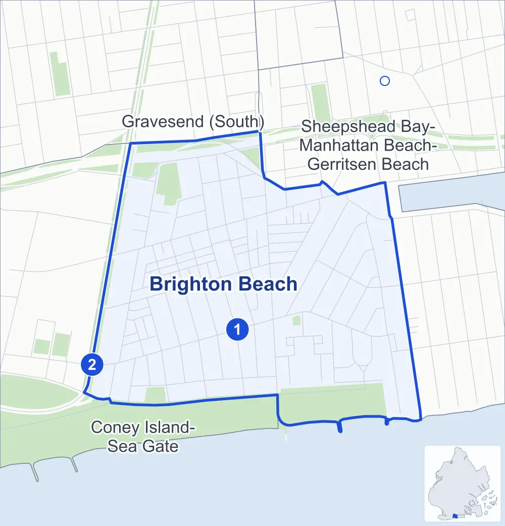
- Brighton Beach
- A neighboring area
- Park
- A station in the list
- Another station
Neighborhood areas and streets: NYC Department of City Planning. Parks: NYC Parks. Stations: MTA.
Neighboring areas
Subway stations
- Brighton Beach lines B Q
- Ocean Pkwy lines Q
Getting around
Two subway stations and buses on eight routes stop in or at the edge of Brighton Beach.
- 2 subway stations
- 7 local bus routes
- 1 express bus route
Local bus routes
- B1
- B4
- B36
- B49
- B68
- B102
- T464
Express bus route
- BM3
Safety record
Between 2021 and 2025, its corners averaged fewer police-reported crashes than the average Brooklyn corner.
- 984 police-reported crashes at its corners
- 5.8 a corner, on average
- 10.5 the average Brooklyn corner
- 51 corners with a clean record
Signal or safety changes on City record, at 19 of its corners
- Leading pedestrian intervals
- 16
- Accessible pedestrian signals
- 6
- Turn calming
- 6
- Safety Improvement Projects
- 1
Camera tickets
In 2025 its corners had more school-zone speed camera tickets than red-light or bus-lane tickets.
- 3,398 red-light camera tickets at one corner
- 21,826 school-zone speed camera tickets at two corners
- 0 bus-lane camera tickets
- Most red-light tickets
- Shore Parkway & Ocean Parkway, 3,398
- Most speed tickets
- Shore Parkway & Ocean Parkway, 21,696
People and homes
The 2020 Census counted 33,568 residents in Brighton Beach, about 68,500 per square mile.
- 14,854 homes, 2020 Census
- 668 homes added since April 2010, net, by City Planning's count
Half of its 1,610 residential lots hold buildings from 1930 or earlier, and 74% of them date from before 1940, by the City's tax lot records.
Parks
- Parkland
- 23.1 acres of NYC Parks property
- The largest pieces
- Coney Island Beach & Boardwalk (18.2 acres), Grady Playground (3.4 acres) and Brighton Playground (1.2 acres)
Streets and trees
- Trees
- 1,458 in NYC Parks' records, most often thornless honeylocust, London planetree and Japanese zelkova
- Street with the most corners
- Brighton Beach Avenue, with 20 of the area's 170
- Height above sea level
- From 5 feet at Brighton 1st Street & Brighton 1st Court to 13 feet at Seacoast Terrace & Brightwater Avenue
- Honorary street names
- 7 at its corners, enacted by local law
Schools and libraries
The City lists nine schools and one library in Brighton Beach.
- Public schools
- 5
- Charter and private schools
- 4
- Library
- Brighton Beach Library
Public safety
How complaints are countedIn 2025 the NYPD recorded 228 major felonies at places in Brighton Beach.
Recorded by the NYPD at places in Brighton Beach
- 219 major felonies in 2024
- 912 other felonies, misdemeanors and violations in 2025
In 2025, on the streets along the edge of Brighton Beach, the NYPD recorded another 74 major felonies. Counting the streets along its edge, in 2025 the NYPD recorded 9.0 major felonies for every thousand residents the 2020 Census counted in Brighton Beach.
- Police precincts
- 60th (most of the area), 61st
From January to June 2026 the NYPD recorded 128 major felonies at places in Brighton Beach, against 91 in the same months of 2025.
Sources: the NYPD's Complaint Data Historic, updated April 28, 2026, and Complaint Data Current (Year To Date), updated July 27, 2026, on NYC Open Data. Figures to June 30, 2026.
Street corners
- Belt Parkway & Coney Island Avenue
- Boardwalk East & Beach Walk
- Brighton 1 Path & Brighton 1st Lane
- Brighton 1 Path & Brighton 1st Walk
- Brighton 1st Place & Brighton 1st Lane
- Brighton 1st Place & Brighton 1st Street
- Brighton 1st Place & Brighton 1st Terrace
- Brighton 1st Place & Brighton 1st Walk
- Brighton 1st Place & Brightwater Court
- Brighton 1st Street & Brighton 1st Court
- Brighton 1st Street & Brighton 1st Lane
- Brighton 1st Street & Brighton 1st Terrace
- Brighton 1st Street & Brighton 2nd Lane
- Brighton 2 Path & Brighton 2nd Walk
- Brighton 2nd Lane & Brighton 2 Path
- Brighton 2nd Place & Brighton 2nd Lane
- Brighton 2nd Place & Brighton 2nd Walk
- Brighton 2nd Street & Boardwalk East
- Brighton 2nd Street & Brighton 1st Court
- Brighton 2nd Street & Brighton 1st Lane
- Brighton 2nd Street & Brighton 1st Walk
- Brighton 3rd Lane & Brighton 3rd Place
- Brighton 3rd Street & Banner 3rd Road
- Brighton 3rd Street & Banner 3rd Terrace
- Brighton 3rd Street & Brighton 2nd Lane
- Brighton 3rd Street & Brighton 2nd Place
- Brighton 3rd Street & Brighton 3rd Lane
- Brighton 3rd Street & Brighton 3rd Road
- Brighton 3rd Street & Brighton 3rd Walk
- Brighton 3rd Street & Brightwater Court
- Brighton 4th Place & Brighton 4th Lane
- Brighton 4th Street & Brighton 3rd Court
- Brighton 4th Street & Brighton 3rd Lane
- Brighton 4th Street & Brighton 3rd Walk
- Brighton 4th Street & Brighton 4th Road
- Brighton 4th Street & Brighton 4th Terrace
- Brighton 4th Street & Brightwater Court
- Brighton 5th Place & Brighton 5th Lane
- Brighton 5th Street & Brighton 4th Court
- Brighton 5th Street & Brighton 4th Lane
- Brighton 5th Street & Brighton 4th Walk
- Brighton 6th Street & Banner Avenue
- Brighton 6th Street & Boardwalk East
- Brighton 6th Street & Brighton 4th Road
- Brighton 6th Street & Brighton 4th Terrace
- Brighton 6th Street & Brighton 5th Court
- Brighton 6th Street & Brighton 5th Lane
- Brighton 6th Street & Brighton 5th Walk
- Brighton 6th Street & Brightwater Court
- Brighton 7th Street & Banner Avenue
- Brighton 7th Street & Brighton 7th Court
- Brighton 7th Street & Brighton 7th Lane
- Brighton 7th Street & Brighton 7th Walk
- Brighton 7th Street & Brighton 8th Street
- Brighton 7th Street & Brightwater Court
- Brighton 8th Place & Brighton 8th Lane
- Brighton 8th Street & Banner Avenue
- Brighton 8th Street & Brighton 7th Court
- Brighton 8th Street & Brighton 7th Lane
- Brighton 8th Street & Brighton 7th Walk
- Brighton 8th Street & Brighton 8th Court
- Brighton 10th Court & Fay Court
- Brighton 10th Court & Holt Court
- Brighton 10th Court & Ide Court
- Brighton 10th Street & Brighton 10 Path
- Brighton 10th Street & Brighton 10th Court
- Brighton 10th Street & Brighton 10th Lane
- Brighton 10th Street & Brighton 10th Terrace
- Brighton 15th Street & Brighton 14th Street
- Brighton 15th Street & Brightwater Avenue
- Brighton Beach Avenue & Beach Walk
- Brighton Beach Avenue & Brighton 1st Place
- Brighton Beach Avenue & Brighton 1st Road
- Brighton Beach Avenue & Brighton 1st Street
- Brighton Beach Avenue & Brighton 2nd Street
- Brighton Beach Avenue & Brighton 3rd Street
- Brighton Beach Avenue & Brighton 4th Street
- Brighton Beach Avenue & Brighton 5th Street
- Brighton Beach Avenue & Brighton 6th Street
- Brighton Beach Avenue & Brighton 7th Street
- Brighton Beach Avenue & Brighton 11th Street
- Brighton Beach Avenue & Brighton 12th Street
- Brighton Beach Avenue & Brighton 13th Street
- Brighton Beach Avenue & Brighton 14th Street
- Brighton Beach Avenue & Brighton 15th Street
- Brighton Beach Avenue & Corbin Place
- Brighton Beach Avenue & Oceana Terrace
- Brighton Beach Avenue & Seacoast Terrace
- Brightwater Court & Brighton 1st Road
- Brightwater Court & Brighton 2nd Street
- Brightwater Court & Brighton 5th Street
- Coney Island Avenue & Belt Parkway at Banner Avenue
- Coney Island Avenue & Boardwalk East
- Coney Island Avenue & Brighton 8th Court
- Coney Island Avenue & Brighton 8th Lane
- Coney Island Avenue & Brighton 10 Path
- Coney Island Avenue & Brighton 10th Court
- Coney Island Avenue & Brighton 10th Lane
- Coney Island Avenue & Brighton 10th Street
- Coney Island Avenue & Brighton 10th Terrace
- Coney Island Avenue & Brighton Beach Avenue
- Coney Island Avenue & Brightwater Court
- Coney Island Avenue & Guider Avenue
- Coney Island Avenue & Neptune Avenue
- Coney Island Avenue & Ocean View Avenue
- Coney Island Avenue & Oceana Drive West
- Corbin Place & Brighton 12th Street
- Corbin Place & Brighton 13th Street
- Corbin Place & Brighton 14th Street
- Corbin Place & Brighton 15th Street
- Corbin Place & Cass Place
- East 12th Street & Guider Avenue
- East 12th Street & Neptune Avenue
- East 14th Street & Neptune Avenue
- Gray Court & Brighton 10th Court
- Neptune Avenue & Athlone Court
- Neptune Avenue & Brighton 1st Street
- Neptune Avenue & Brighton 3rd Street
- Neptune Avenue & Brighton 4th Street
- Neptune Avenue & Brighton 5th Street
- Neptune Avenue & Brighton 6th Street
- Neptune Avenue & Brighton 7th Street
- Neptune Avenue & Brighton 8th Street
- Neptune Avenue & Brighton 10th Street
- Neptune Avenue & East 11th Street
- Neptune Avenue & Gray Court
- Ocean Parkway & Brighton Beach Avenue
- Ocean Parkway & Ocean View Avenue
- Ocean Parkway & West Avenue
- Ocean View Avenue & Brighton 1st Street
- Ocean View Avenue & Brighton 2nd Street
- Ocean View Avenue & Brighton 3rd Place
- Ocean View Avenue & Brighton 3rd Street
- Ocean View Avenue & Brighton 4th Place
- Ocean View Avenue & Brighton 4th Street
- Ocean View Avenue & Brighton 5th Place
- Ocean View Avenue & Brighton 5th Street
- Ocean View Avenue & Brighton 6th Street
- Ocean View Avenue & Brighton 7th Street
- Ocean View Avenue & Brighton 8th Place
- Ocean View Avenue & Brighton 8th Street
- Ocean View Avenue & Brighton 10th Street
- Ocean View Avenue & Brighton 11th Street
- Ocean View Avenue & Brighton 12th Street
- Ocean View Avenue & Brighton 13th Street
- Ocean View Avenue & Brighton 14th Street
- Ocean View Avenue & Corbin Place
- Oceana Drive East & Oceana Drive West
- Oriental Boulevard & Corbin Place
- Oriental Boulevard & Gerald H Chambers Square
- Oriental Boulevard & West End Avenue
- Sea Breeze Avenue & Beach Walk
- Seacoast Terrace & Brightwater Avenue
- Seacoast Terrace & Oceana Drive East
- Shore Boulevard & West End Avenue
- Shore Parkway & Belt Parkway (Exit 7)
- Shore Parkway & Belt Parkway (Exit 8)
- Shore Parkway & Brighton 3rd Street
- Shore Parkway & Brighton 6th Street
- Shore Parkway & Brighton 7th Street
- Shore Parkway & Brighton 8th Street
- Shore Parkway & Coney Island Avenue
- Shore Parkway & East 7th Street
- Shore Parkway & Guider Avenue
- Shore Parkway & Hubbard St-Guider Avenue Pedestrian Overpass
- Shore Parkway & Hubbard Street
- Shore Parkway & Ocean Parkway
- West End Avenue & Neptune Court
- West End Avenue & Ocean Court
- West End Avenue & Sea Breeze Court
How the figures above are measured: Methodology.