Sheepshead Bay-Manhattan Beach-Gerritsen Beach
Neighborhood · Brooklyn
Sheepshead Bay-Manhattan Beach-Gerritsen Beach wraps around the bay in southern Brooklyn, from the Emmons Avenue piers, where boats head out on fishing trips, to Manhattan Beach on the ocean and the Gerritsen Beach peninsula beside Plumb Beach Channel.
- 2.27 square miles
- 69,084 residents, 2020 Census
- 461 street corners
- 2 subway stations
- 13 bus routes
The bay is usually said to be named for the sheepshead, a fish once abundant in these waters, and the 1934 Lundy Brothers Restaurant building on Emmons Avenue, in Spanish Colonial Revival style, is a city landmark. Austin Corbin built the Manhattan Beach Hotel in 1877, Kingsborough Community College now fills Manhattan Beach's eastern tip, and Gerritsen Beach began in 1920 as a summer resort.
Sources: Sheepshead Bay, Brooklyn (Wikipedia); F.W.I.L. Lundy Brothers Restaurant Building (LP-1706) (NYC Landmarks Preservation Commission); Manhattan Beach, Brooklyn (Wikipedia); Gerritsen Beach, Brooklyn (Wikipedia).
Sheepshead Bay-Manhattan Beach-Gerritsen Beach borders five areas, and Shore Parkway holds more of its corners than any other street, 41 of 461.
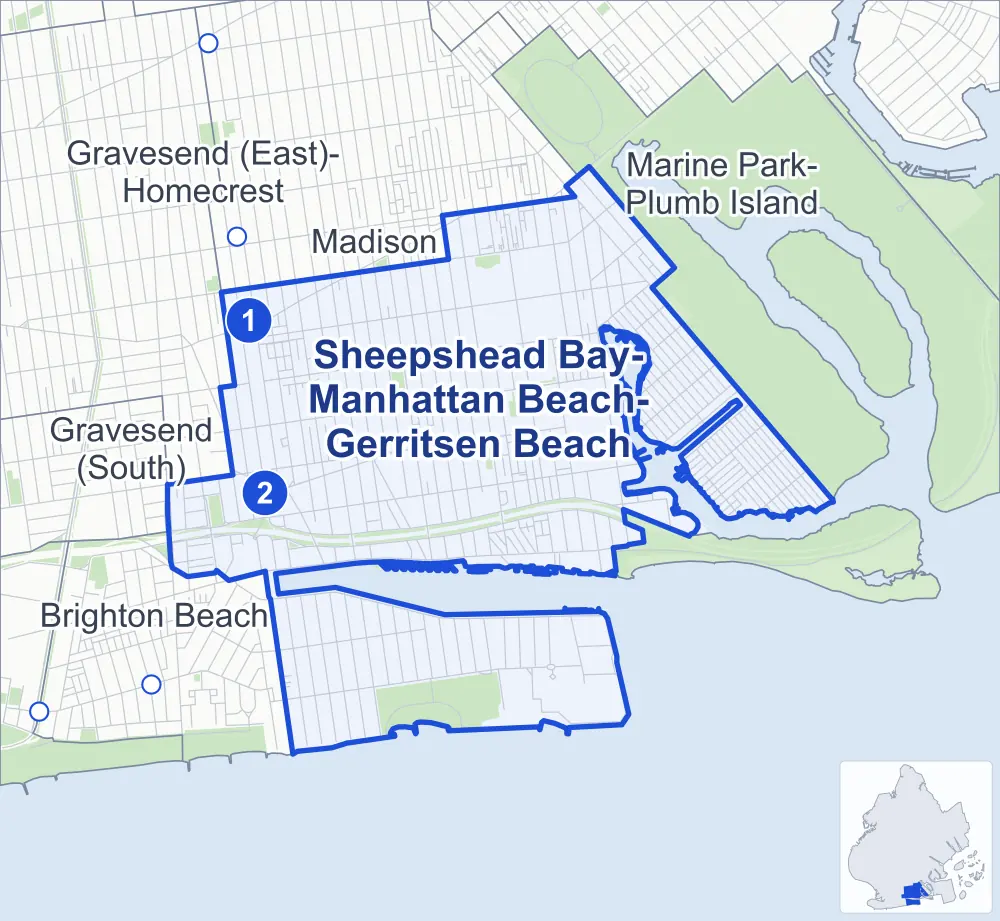
- Sheepshead Bay-Manhattan Beach-Gerritsen Beach
- A neighboring area
- Park
- A station in the list
- Another station
Neighborhood areas and streets: NYC Department of City Planning. Parks: NYC Parks. Stations: MTA.
Neighboring areas
- Madison north
- Marine Park-Plumb Island east
- Brighton Beach southwest
- Gravesend (East)-Homecrest west
- Gravesend (South) west
Subway stations
- Neck Rd lines Q
- Sheepshead Bay lines B Q accessible
Getting around
Two subway stations and buses on 13 routes stop in or at the edge of Sheepshead Bay-Manhattan Beach-Gerritsen Beach.
- 2 subway stations
- 1 of them listed by the MTA as fully accessible
- 11 local bus routes
- 2 express bus routes
Local bus routes
- B1
- B3
- B4
- B31
- B36
- B44
- B44-SBS
- B49
- B68
- B102
- T464
Express bus routes
- BM3
- BM4
Safety record
Between 2021 and 2025, its corners averaged fewer police-reported crashes than the average Brooklyn corner.
- 1,987 police-reported crashes at its corners
- 4.3 a corner, on average
- 10.5 the average Brooklyn corner
- 154 corners with a clean record
Signal or safety changes on City record, at 83 of its corners
- Leading pedestrian intervals
- 67
- Accessible pedestrian signals
- 17
- Turn calming
- 10
- Enhanced crossings
- 9
- Barnes Dance all-way crossings
- 2
Camera tickets
In 2025 its corners had more school-zone speed camera tickets than red-light or bus-lane tickets.
- 0 red-light camera tickets
- 72,592 school-zone speed camera tickets at 31 corners
- 0 bus-lane camera tickets
- Most speed tickets
- Shore Parkway & Knapp Street, 20,084
People and homes
The 2020 Census counted 69,084 residents in Sheepshead Bay-Manhattan Beach-Gerritsen Beach, about 30,400 per square mile.
- 28,707 homes, 2020 Census
- 979 homes added since April 2010, net, by City Planning's count
Half of its 8,662 residential lots hold buildings from 1935 or earlier, and 52% of them date from before 1940, by the City's tax lot records.
NYCHA developments
NYCHA's Nostrand and Sheepshead Bay developments lie wholly or partly within Sheepshead Bay-Manhattan Beach-Gerritsen Beach.
Parks and landmarks
- Parkland
- 52.6 acres of NYC Parks property
- The largest pieces
- Manhattan Beach Park (40 acres), Bill Brown Playground (3.3 acres) and Homecrest Playground (2.2 acres)
- Designated landmark
- The F.W.I.L. Lundy Brothers Restaurant Building
Streets and trees
- Trees
- 6,526 in NYC Parks' records, most often London planetree, pin oak and thornless honeylocust
- Street with the most corners
- Shore Parkway, with 41 of the area's 461
- Height above sea level
- From 3 feet at Stanton Road & Losee Terrace to 25 feet at Shore Parkway & Knapp Street
- Honorary street names
- 15 at its corners, enacted by local law
Schools and libraries
The City lists 22 schools and three libraries in Sheepshead Bay-Manhattan Beach-Gerritsen Beach.
- Public schools
- 11
- Charter and private schools
- 11
- Libraries
- Gerritsen Beach Library, Kings Bay Library and Sheepshead Bay Library
Public art
The City's public art inventory lists two works in Sheepshead Bay-Manhattan Beach-Gerritsen Beach: Design Team Project (1994) and Wave Wall in Green (1996).
- 2 works of public art
Public safety
How complaints are countedIn 2025 the NYPD recorded 546 major felonies at places in Sheepshead Bay-Manhattan Beach-Gerritsen Beach.
Recorded by the NYPD at places in Sheepshead Bay-Manhattan Beach-Gerritsen Beach
- 604 major felonies in 2024
- 1,935 other felonies, misdemeanors and violations in 2025
In 2025, on the streets along the edge of Sheepshead Bay-Manhattan Beach-Gerritsen Beach, the NYPD recorded another 71 major felonies. Counting the streets along its edge, in 2025 the NYPD recorded 8.9 major felonies for every thousand residents the 2020 Census counted in Sheepshead Bay-Manhattan Beach-Gerritsen Beach.
- Police precinct
- 61st
From January to June 2026 the NYPD recorded 263 major felonies at places in Sheepshead Bay-Manhattan Beach-Gerritsen Beach, against 265 in the same months of 2025.
Sources: the NYPD's Complaint Data Historic, updated April 28, 2026, and Complaint Data Current (Year To Date), updated July 27, 2026, on NYC Open Data. Figures to June 30, 2026.
Street corners
- Abbey Court & Bartlett Place
- Abbey Court & Cyrus Avenue
- Abbey Court & Lois Avenue
- Abbey Court & Seba Avenue
- Amherst Street & Hampton Avenue
- Aster Court & Allen Avenue
- Aster Court & Bijou Avenue
- Aster Court & Channel Avenue
- Aster Court & Devon Avenue
- Aster Court & Everett Avenue
- Aster Court & Florence Avenue
- Avenue U & Bragg Street
- Avenue U & Brigham Street
- Avenue U & Brown Street
- Avenue U & Burnett Street
- Avenue U & Gerritsen Avenue
- Avenue U & Gravesend Neck Road
- Avenue V & Batchelder Street
- Avenue V & Bragg Street
- Avenue V & Brigham Street
- Avenue V & Brown Street
- Avenue V & Burnett Street
- Avenue V & Coyle Street
- Avenue V & East 15th Street
- Avenue V & Ford Street
- Avenue V & Gerritsen Avenue
- Avenue V & Haring Street
- Avenue V & Knapp Street
- Avenue V & Stuart Street
- Avenue W & Batchelder Street
- Avenue W & Bragg Street
- Avenue W & Brigham Street
- Avenue W & Gerritsen Avenue
- Avenue W & Knapp Street
- Avenue W & Plumb 1st Street
- Avenue W & Plumb 2nd Street
- Avenue X & Batchelder Street
- Avenue X & Bragg Street
- Avenue X & Brigham Street
- Avenue X & Brown Street
- Avenue X & Burnett Street
- Avenue X & Coyle Street
- Avenue X & East 15th Street
- Avenue X & East 16th Street
- Avenue X & Gerritsen Avenue
- Avenue X & Haring Street
- Avenue X & Knapp Street
- Avenue X & Stuart Street
- Avenue Y & Batchelder Street
- Avenue Y & Bragg Street
- Avenue Y & Brigham Street
- Avenue Y & Brown Street
- Avenue Y & Coyle Street
- Avenue Y & Haring Street
- Avenue Y & Knapp Street
- Avenue Z & Batchelder Street
- Avenue Z & Brown Street
- Avenue Z & Coyle Street
- Avenue Z & East 11th Street
- Avenue Z & Ford Street
- Avenue Z & Haring Street
- Avenue Z & Jerome Avenue
- Avenue Z & Sheepshead Bay Road
- Bartlett Place & Gain Court
- Bartlett Place & Hymen Court
- Bartlett Place & Ivan Court
- Bartlett Place & Just Court
- Batchelder Street & Emmons Avenue
- Batchelder Street & Gunnison Court
- Batchelder Street & Losee Terrace
- Batchelder Street & Voorhies Avenue
- Beacon Court & Bartlett Place
- Beacon Court & Cyrus Avenue
- Beacon Court & Lois Avenue
- Beacon Court & Seba Avenue
- Beaumont Street & Hampton Avenue
- Bedford Avenue & Avenue W
- Bedford Avenue & Avenue X
- Bedford Avenue & Avenue Y
- Bedford Avenue & Avenue Z
- Bedford Avenue & Emmons Avenue
- Bedford Avenue & Shore Parkway
- Bedford Avenue & Voorhies Avenue
- Belt Parkway & Bedford Avenue
- Belt Parkway & East 12th Street
- Belt Parkway & Knapp Street
- Belt Parkway & Nostrand Avenue
- Belt Parkway & Ocean Avenue
- Belt Parkway & Sheepshead Bay Road
- Belt Parkway & Voorhies Avenue-East 14th Street Pedestrian Overpass
- Belt Parkway & Voorhies Avenue-East 14th Street Pedestrian Overpass (East 14th Street)
- Bevy Court & Allen Avenue
- Bevy Court & Bijou Avenue
- Bevy Court & Channel Avenue
- Bevy Court & Devon Avenue
- Bevy Court & Everett Avenue
- Bevy Court & Florence Avenue
- Brown Street & Dunne Place
- Brown Street & Gunnison Court
- Brown Street & Losee Terrace
- Brown Street & Voorhies Avenue
- Burnett Street & Whitney Avenue
- Canton Court & Bartlett Place
- Canton Court & Cyrus Avenue
- Canton Court & Lois Avenue
- Canton Court & Seba Avenue
- Celeste Court & Allen Avenue
- Celeste Court & Bijou Avenue
- Celeste Court & Channel Avenue
- Celeste Court & Devon Avenue
- Celeste Court & Everett Avenue
- Celeste Court & Florence Avenue
- Coleridge Street & Hampton Avenue
- Coney Island Avenue & Avenue Z
- Coney Island Avenue & Banner Avenue
- Coney Island Avenue & Belt Parkway
- Coney Island Avenue & Manor Court
- Coyle Street & Voorhies Avenue
- Cyrus Avenue & Gain Court
- Cyrus Avenue & Hymen Court
- Cyrus Avenue & Ivan Court
- Cyrus Avenue & Just Court
- Cyrus Avenue & Madoc Avenue
- Dare Court & Bartlett Place
- Dare Court & Cyrus Avenue
- Dare Court & Lois Avenue
- Dare Court & Seba Avenue
- Devon Avenue & Garland Court
- Devon Avenue & Hazel Court
- Devon Avenue & Ira Court
- Dictum Court & Allen Avenue
- Dictum Court & Bijou Avenue
- Dictum Court & Channel Avenue
- Dictum Court & Devon Avenue
- Dictum Court & Everett Avenue
- Dictum Court & Florence Avenue
- Dover Street & Hampton Avenue
- East 11th Street & Banner Avenue
- East 11th Street & Blake Court
- East 11th Street & Gilmore Court
- East 11th Street & Guider Avenue
- East 11th Street & Lawn Court
- East 11th Street & William Court
- East 12th Street & Avenue Z
- East 12th Street & Gilmore Court
- East 12th Street & William Court
- East 13th Street & Avenue Z
- East 13th Street & Margaret Court
- East 13th Street & Nassau Court
- East 14th Street & Avenue V
- East 14th Street & Avenue X
- East 14th Street & Avenue Y
- East 14th Street & Avenue Z
- East 14th Street & Sheepshead Bay Road
- East 15th Street & Avenue W
- East 15th Street & Avenue Y
- East 15th Street & Avenue Z
- East 15th Street & Emmons Avenue
- East 15th Street & Gravesend Neck Road
- East 15th Street & Sheepshead Bay Road
- East 16th Street & Avenue W
- East 16th Street & Avenue Y
- East 16th Street & Avenue Z
- East 16th Street & Bay Court
- East 16th Street & Emmons Avenue
- East 16th Street & Gravesend Neck Road
- East 16th Street & Sheepshead Bay Road
- East 16th Street & Voorhies Avenue
- East 17th Street & Avenue W
- East 17th Street & Avenue X
- East 17th Street & Avenue Y
- East 17th Street & Avenue Z
- East 17th Street & Gravesend Neck Road
- East 17th Street & Jerome Avenue
- East 18th Street & Avenue V
- East 18th Street & Avenue W
- East 18th Street & Avenue X
- East 18th Street & Avenue Y
- East 18th Street & Avenue Z
- East 18th Street & Gravesend Neck Road
- East 18th Street & Jerome Avenue
- East 18th Street & Voorhies Avenue
- East 19th Street & Avenue W
- East 19th Street & Avenue X
- East 19th Street & Avenue Y
- East 19th Street & Avenue Z
- East 19th Street & Emmons Avenue
- East 19th Street & Gravesend Neck Road
- East 19th Street & Jerome Avenue
- East 19th Street & Voorhies Avenue
- East 21st Street & Avenue V
- East 21st Street & Avenue W
- East 21st Street & Avenue X
- East 21st Street & Avenue Y
- East 21st Street & Avenue Z
- East 21st Street & Emmons Avenue
- East 21st Street & Gravesend Neck Road
- East 21st Street & Jerome Avenue
- East 21st Street & Kenmore Court
- East 21st Street & Voorhies Avenue
- East 22nd Street & Avenue V
- East 22nd Street & Avenue W
- East 22nd Street & Avenue X
- East 22nd Street & Avenue Y
- East 22nd Street & Avenue Z
- East 22nd Street & Gravesend Neck Road
- East 22nd Street & Jerome Avenue
- East 22nd Street & Kenmore Court
- East 22nd Street & Voorhies Avenue
- East 23rd Street & Avenue W
- East 23rd Street & Avenue X
- East 23rd Street & Avenue Y
- East 23rd Street & Avenue Z
- East 23rd Street & Emmons Avenue
- East 23rd Street & Jerome Avenue
- East 23rd Street & Voorhies Avenue
- East 24th Street & Avenue W
- East 24th Street & Avenue X
- East 24th Street & Avenue Y
- East 24th Street & Avenue Z
- East 24th Street & Voorhies Avenue
- East 26th Street & Avenue W
- East 26th Street & Avenue X
- East 26th Street & Avenue Y
- East 26th Street & Avenue Z
- East 26th Street & Emmons Avenue
- East 26th Street & Voorhies Avenue
- East 27th Street & Avenue W
- East 27th Street & Avenue X
- East 27th Street & Avenue Y
- East 27th Street & Avenue Z
- East 27th Street & Emmons Avenue
- East 27th Street & Voorhies Avenue
- East 28th Street & Avenue W
- East 28th Street & Avenue X
- East 28th Street & Avenue Y
- East 28th Street & Avenue Z
- East 28th Street & Emmons Avenue
- East 28th Street & Jerome Avenue
- East 28th Street & Voorhies Avenue
- East 29th Street & Avenue V
- East 29th Street & Avenue W
- East 29th Street & Avenue X
- East 29th Street & Avenue Y
- East 29th Street & Avenue Z
- East 29th Street & Canda Avenue
- East 29th Street & Emmons Avenue
- East 29th Street & Voorhies Avenue
- Eaton Court & Bartlett Place
- Eaton Court & Cyrus Avenue
- Eaton Court & Lois Avenue
- Eaton Court & Seba Avenue
- Ebony Court & Allen Avenue
- Ebony Court & Bijou Avenue
- Ebony Court & Channel Avenue
- Ebony Court & Devon Avenue
- Ebony Court & Everett Avenue
- Ebony Court & Florence Avenue
- Emmons Avenue & Belt Parkway
- Emmons Avenue & Brigham Street
- Emmons Avenue & Coyle Street
- Emmons Avenue & Dooley Street
- Emmons Avenue & Ford Street
- Emmons Avenue & Plumb 1st Street
- Emmons Avenue & Plumb 3rd Street
- Emmons Avenue & Sheepshead Bay Road
- Everett Avenue & Fane Court
- Everett Avenue & Garland Court
- Everett Avenue & Hazel Court
- Everett Avenue & Ira Court
- Everett Avenue & Joval Court
- Everett Avenue & Knight Court
- Everett Avenue & Lacon Court
- Fane Court & Devon Avenue
- Florence Avenue & Fane Court
- Florence Avenue & Garland Court
- Florence Avenue & Hazel Court
- Florence Avenue & Ira Court
- Florence Avenue & Joval Court
- Florence Avenue & Knight Court
- Ford Street & Kouwenhoven Lane
- Frank Court & Bartlett Place
- Frank Court & Cyrus Avenue
- Frank Court & Lois Avenue
- Frank Court & Seba Avenue
- Gain Court & Lois Avenue
- Garland Court & Allen Avenue
- Gerritsen Avenue & Allen Avenue
- Gerritsen Avenue & Bartlett Place
- Gerritsen Avenue & Bijou Avenue
- Gerritsen Avenue & Channel Avenue
- Gerritsen Avenue & Cyrus Avenue
- Gerritsen Avenue & Devon Avenue
- Gerritsen Avenue & Everett Avenue
- Gerritsen Avenue & Florence Avenue
- Gerritsen Avenue & Gotham Avenue
- Gerritsen Avenue & Knapp Street
- Gerritsen Avenue & Lois Avenue
- Gerritsen Avenue & Plumb 1st Street
- Gerritsen Avenue & Seba Avenue
- Gerritsen Avenue & Whitney Avenue
- Gotham Avenue & Fane Court South
- Hampton Avenue & Exeter Street
- Hampton Avenue & Falmouth Street
- Hampton Avenue & Girard Street
- Hampton Avenue & Hastings Street
- Hampton Avenue & Irwin Street
- Haring Street & Dunne Place
- Haring Street & Voorhies Avenue
- Harkness Avenue & Plumb 2nd Street
- Homecrest Avenue & Guider Avenue
- Homecrest Avenue & Nassau Court
- Homecrest Avenue & William Court
- Just Court & Kay Court
- Just Court & Landis Court
- Just Court & Merit Court
- Just Court & Opal Court
- Keen Court & Madoc Avenue
- Knapp Street & Allen Avenue
- Knapp Street & Emmons Avenue
- Knapp Street & Emmons Avenue at Belt Parkway
- Knapp Street & Harkness Avenue
- Knapp Street & Voorhies Avenue
- Knapp Street & Whitney Avenue
- Lester Court & Madoc Avenue
- Lois Avenue & Hymen Court
- Madoc Avenue & Melba Court
- Madoc Avenue & Nova Court
- Madoc Avenue & Opal Court
- Madoc Avenue & Post Court
- Mesereau Court & Dunne Place
- Neptune Avenue & Cass Place
- Neptune Avenue & Guider Avenue
- Neptune Avenue & Shore Boulevard
- Noel Avenue & Bartlett Place
- Noel Avenue & Cyrus Avenue
- Noel Avenue & Keen Court
- Noel Avenue & Lester Court
- Noel Avenue & Lois Avenue
- Noel Avenue & Melba Court
- Noel Avenue & Nova Court
- Noel Avenue & Seba Avenue
- Nostrand Avenue & Avenue V
- Nostrand Avenue & Avenue W
- Nostrand Avenue & Avenue X
- Nostrand Avenue & Avenue Y
- Nostrand Avenue & Avenue Z
- Nostrand Avenue & Emmons Avenue
- Nostrand Avenue & Gravesend Neck Road
- Nostrand Avenue & Voorhies Avenue
- Ocean Avenue & Avenue V
- Ocean Avenue & Avenue W
- Ocean Avenue & Avenue X
- Ocean Avenue & Avenue Y
- Ocean Avenue & Avenue Z
- Ocean Avenue & Emmons Avenue
- Ocean Avenue & Gravesend Neck Road
- Ocean Avenue & Hampton Avenue
- Ocean Avenue & Jerome Avenue
- Ocean Avenue & Oriental Boulevard
- Ocean Avenue & Shore Boulevard
- Ocean Avenue & Voorhies Avenue
- Ocean View Avenue & West End Avenue
- Oriental Boulevard & Amherst Street
- Oriental Boulevard & Beaumont Street
- Oriental Boulevard & Coleridge Street
- Oriental Boulevard & Decatur Avenue
- Oriental Boulevard & Dover Street
- Oriental Boulevard & Exeter Street
- Oriental Boulevard & Falmouth Street
- Oriental Boulevard & Girard Street
- Oriental Boulevard & Hastings Street
- Oriental Boulevard & Irwin Street
- Oriental Boulevard & Jaffray Street
- Oriental Boulevard & Kensington Street
- Oriental Boulevard & Langham Street
- Oriental Boulevard & Mackenzie Street
- Oriental Boulevard & Norfolk Street
- Oriental Boulevard & Oxford Street
- Oriental Boulevard & Perry Avenue
- Oriental Boulevard & Quentin Street
- Oriental Boulevard & Seawall Avenue
- Perry Avenue & John Berry Boulevard
- Plumb 1st Street & Fane Court
- Plumb 1st Street & Harkness Avenue
- Plumb 1st Street & Whitney Avenue
- Plumb 3rd Street & Harkness Avenue
- Seba Avenue & Gain Court
- Seba Avenue & Hymen Court
- Seba Avenue & Ivan Court
- Seba Avenue & Just Court
- Seba Avenue & Madoc Avenue
- Sheepshead Bay Road & Jerome Avenue
- Shore Boulevard & Amherst Street
- Shore Boulevard & Beaumont Street
- Shore Boulevard & Coleridge Street
- Shore Boulevard & Decatur Avenue
- Shore Boulevard & Dover Street
- Shore Boulevard & Exeter Street
- Shore Boulevard & Falmouth Street
- Shore Boulevard & Girard Street
- Shore Boulevard & Hastings Street
- Shore Boulevard & Irwin Street
- Shore Boulevard & Jaffray Street
- Shore Boulevard & Kensington Street
- Shore Boulevard & Langham Street
- Shore Boulevard & Mackenzie Street
- Shore Boulevard & Norfolk Street
- Shore Boulevard & Oxford Street
- Shore Boulevard & Pembroke Street
- Shore Boulevard & Quentin Street
- Shore Boulevard & Seawall Avenue
- Shore Parkway & Batchelder Street
- Shore Parkway & Bay Court
- Shore Parkway & Belt Parkway
- Shore Parkway & Belt Parkway (Coney Island Avenue)
- Shore Parkway & Belt Parkway (East 14th Street)
- Shore Parkway & Bragg Street
- Shore Parkway & Brigham Street
- Shore Parkway & Brown Street
- Shore Parkway & Coyle Street
- Shore Parkway & Dooley Street
- Shore Parkway & East 11th Street
- Shore Parkway & East 12th Street
- Shore Parkway & East 13th Street
- Shore Parkway & East 13th Street at Belt Parkway
- Shore Parkway & East 14th Street
- Shore Parkway & East 14th Street at Belt Parkway
- Shore Parkway & East 15th Street
- Shore Parkway & East 16th Street
- Shore Parkway & East 19th Street
- Shore Parkway & East 21st Street
- Shore Parkway & East 22nd Street
- Shore Parkway & East 23rd Street
- Shore Parkway & East 26th Street
- Shore Parkway & East 27th Street
- Shore Parkway & East 28th Street
- Shore Parkway & East 29th Street
- Shore Parkway & Emmons Avenue
- Shore Parkway & Ford Street
- Shore Parkway & Ford Street at Belt Parkway
- Shore Parkway & Haring Street
- Shore Parkway & Harkness Avenue
- Shore Parkway & Knapp Street
- Shore Parkway & Nostrand Avenue
- Shore Parkway & Ocean Avenue
- Shore Parkway & Plumb 3rd Street
- Shore Parkway & Sheepshead Bay Road
- Shore Parkway & Voorhies Avenue
- Shore Parkway & Voorhies Avenue at Belt Parkway
- Shore Parkway & Voorhies Avenue-East 14th Street Pedestrian Overpass (north-east)
- Shore Parkway & Voorhies Avenue-East 14th Street Pedestrian Overpass (south-west)
- Stanton Road & Gunnison Court
- Stanton Road & Losee Terrace
- Stuart Street & Whitney Avenue
- Voorhies Avenue & Bragg Street
- Voorhies Avenue & Dooley Street
- Voorhies Avenue & Ford Street
- Voorhies Avenue & Sheepshead Bay Road
- West End Avenue & Oriental Court
- Whitney Avenue & Plumb 2nd Street
How the figures above are measured: Methodology.