Kensington
Neighborhood · Brooklyn
Kensington stretches from Fort Hamilton Parkway to 18th Avenue and from Dahill Road and 36th Street east to Coney Island Avenue, with Ocean Parkway running through its center.
- 0.63 square miles
- 41,758 residents, 2020 Census
- 95 street corners
- 2 subway stations
- 10 bus routes
Named for the borough in west London, it held scattered farms until the Coney Island Plank Road, now Coney Island Avenue, was laid in the 1850s, and the name took hold after Ocean Parkway was completed in the late 1800s. The parkway, a city scenic landmark since 1975 and the site of the country's first bike path in 1894, is lined here by prewar brick apartment buildings, and elsewhere brick rowhouses mix with detached Victorian houses.
Sources: Kensington, Brooklyn (Forgotten New York); London's Calling: How Kensington Got Its Name (Brownstoner); Ocean Parkway Malls History (NYC Parks); Kensington, Brooklyn (Wikipedia).
Kensington borders four areas, and Church Avenue holds more of its corners than any other street, 11 of 95.
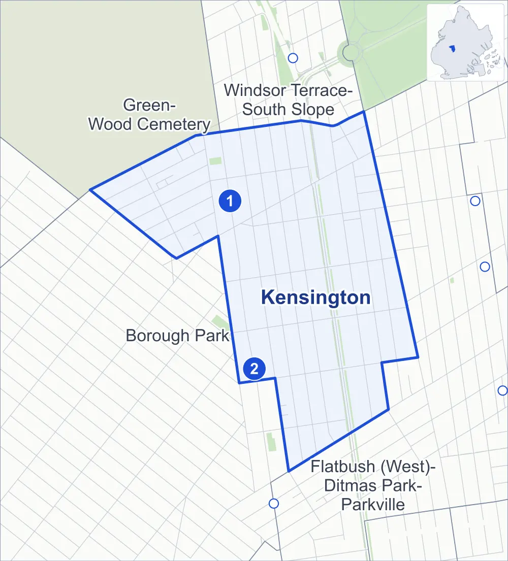
- Kensington
- A neighboring area
- Park
- A station in the list
- Another station
Neighborhood areas and streets: NYC Department of City Planning. Parks: NYC Parks. Stations: MTA.
Neighboring areas
- Windsor Terrace-South Slope north
- Flatbush (West)-Ditmas Park-Parkville southeast
- Borough Park southwest
- Green-Wood Cemetery northwest
Subway stations
- Church Av lines F G accessible
- Ditmas Av lines F
Getting around
Two subway stations and buses on ten routes stop in or at the edge of Kensington.
- 2 subway stations
- 1 of them listed by the MTA as fully accessible
- 8 local bus routes
- 2 express bus routes
Local bus routes
- B8
- B16
- B35
- B67
- B68
- B69
- B90
- B103
Express bus routes
- BM3
- BM4
Safety record
Between 2021 and 2025, its corners averaged fewer police-reported crashes than the average Brooklyn corner.
- 956 police-reported crashes at its corners
- 10.1 a corner, on average
- 10.5 the average Brooklyn corner
- 1 corner with a clean record
Signal or safety changes on City record, at 29 of its corners
- Leading pedestrian intervals
- 20
- Accessible pedestrian signals
- 15
- Turn calming
- 7
- Safety Improvement Projects
- 2
- Barnes Dance all-way crossings
- 1
Camera tickets
In 2025 its corners had more school-zone speed camera tickets than bus-lane or red-light tickets.
- 714 red-light camera tickets at one corner
- 32,820 school-zone speed camera tickets at nine corners
- 4,011 bus-lane camera tickets at one corner
- Most red-light tickets
- Coney Island Avenue & Dorchester Road, 714
- Most speed tickets
- Ocean Parkway & Ditmas Avenue, 10,716
- Most bus-lane tickets
- East 8th Street & Church Avenue, 4,011
People and homes
The 2020 Census counted 41,758 residents in Kensington, about 66,300 per square mile.
- 14,804 homes, 2020 Census
- 360 homes added since April 2010, net, by City Planning's count
Half of its 2,827 residential lots hold buildings from 1925 or earlier, and 91% of them date from before 1940, by the City's tax lot records.
Parks
- Parkland
- 0.5 acre of Albemarle Playground, as NYC Parks maps it within Kensington
Streets and trees
- Trees
- 2,496 in NYC Parks' records, most often London planetree, thornless honeylocust and Japanese zelkova
- Street with the most corners
- Church Avenue, with 11 of the area's 95
- Height above sea level
- From 33 feet at East 9th Street & Ditmas Avenue to 69 feet at 36th Street & Minna Street
- Honorary street names
- 3 at its corners, enacted by local law
Schools
The City lists 17 schools in Kensington.
- Public schools
- 5
- Charter and private schools
- 12
Bike share
By the station list of October 3, 2026, 13 bike-share stations stand in Kensington.
- 13 bike-share stations
Public safety
How complaints are countedIn 2025 the NYPD recorded 233 major felonies at places in Kensington.
Recorded by the NYPD at places in Kensington
- 217 major felonies in 2024
- 698 other felonies, misdemeanors and violations in 2025
In 2025, on the streets along the edge of Kensington, the NYPD recorded another 75 major felonies. Counting the streets along its edge, in 2025 the NYPD recorded 7.4 major felonies for every thousand residents the 2020 Census counted in Kensington.
- Police precincts
- 66th (most of the area), 70th
From January to June 2026 the NYPD recorded 104 major felonies at places in Kensington, against 112 in the same months of 2025.
Sources: the NYPD's Complaint Data Historic, updated April 28, 2026, and Complaint Data Current (Year To Date), updated July 27, 2026, on NYC Open Data. Figures to June 30, 2026.
Street corners
- 12th Avenue & Chester Avenue
- 12th Avenue & Dahill Road
- 15th Avenue & Dahill Road
- 36th Street & Minna Street
- 36th Street & Tehama Street
- Chester Avenue & Clara Street
- Chester Avenue & Louisa Street
- Chester Avenue & Tehama Street
- Church Avenue & 35th Street
- Church Avenue & Beverley Road
- Church Avenue & Chester Avenue
- Church Avenue & Dahill Road
- Church Avenue & East 2nd Street
- Church Avenue & East 3rd Street
- Coney Island Avenue & Caton Avenue
- Coney Island Avenue & Dorchester Road
- Coney Island Avenue & Friel Place
- Coney Island Avenue & Hinckley Place
- Dahill Road & 35th Street
- Dahill Road & Albemarle Road
- Dahill Road & Avenue C
- Dahill Road & Caton Avenue
- Dahill Road & Clara Street
- Dahill Road & Louisa Street
- Dahill Road & Minna Street
- East 2nd Street & Albemarle Road
- East 2nd Street & Avenue C
- East 2nd Street & Beverley Road
- East 2nd Street & Cortelyou Road
- East 2nd Street & Ditmas Avenue
- East 3rd Street & 18th Avenue
- East 3rd Street & Albemarle Road
- East 3rd Street & Avenue C
- East 3rd Street & Avenue F
- East 3rd Street & Beverley Road
- East 3rd Street & Caton Avenue
- East 3rd Street & Cortelyou Road
- East 3rd Street & Ditmas Avenue
- East 4th Street & Albemarle Road
- East 4th Street & Avenue C
- East 4th Street & Avenue F
- East 4th Street & Beverley Road
- East 4th Street & Caton Avenue
- East 4th Street & Church Avenue
- East 4th Street & Cortelyou Road
- East 4th Street & Ditmas Avenue
- East 5th Street & Albemarle Road
- East 5th Street & Avenue C
- East 5th Street & Avenue F
- East 5th Street & Beverley Road
- East 5th Street & Caton Avenue
- East 5th Street & Church Avenue
- East 5th Street & Cortelyou Road
- East 5th Street & Ditmas Avenue
- East 7th Street & Avenue C
- East 7th Street & Beverley Road
- East 7th Street & Church Avenue
- East 7th Street & Cortelyou Road
- East 7th Street & Ditmas Avenue
- East 7th Street & Friel Place
- East 8th Street & 18th Avenue
- East 8th Street & Avenue C
- East 8th Street & Beverley Road
- East 8th Street & Caton Avenue
- East 8th Street & Church Avenue
- East 8th Street & Cortelyou Road
- East 8th Street & Ditmas Avenue
- East 8th Street & Friel Place
- East 8th Street & Hinckley Place
- East 8th Street & Turner Place
- East 9th Street & Avenue C
- East 9th Street & Beverley Road
- East 9th Street & Cortelyou Road
- East 9th Street & Ditmas Avenue
- Fort Hamilton Parkway & Bills Place
- Fort Hamilton Parkway & Caton Avenue
- Fort Hamilton Parkway & Chester Avenue
- Fort Hamilton Parkway & Dahill Road Bike Link
- Fort Hamilton Parkway & Micieli Place
- McDonald Avenue & Albemarle Road
- McDonald Avenue & Avenue C
- McDonald Avenue & Caton Avenue
- McDonald Avenue & Church Avenue
- McDonald Avenue & Cortelyou Road
- Minna Street & Bills Place
- Minna Street & Chester Avenue
- Minna Street & Micieli Place
- Ocean Parkway & Albemarle Road
- Ocean Parkway & Avenue C
- Ocean Parkway & Beverley Road
- Ocean Parkway & Cortelyou Road
- Ocean Parkway & Ditmas Avenue
- Ocean Parkway & Prospect Expressway
- Story Street & Louisa Street
- Story Street & Story Court
How the figures above are measured: Methodology.