Mapleton-Midwood (West)
Neighborhood · Brooklyn
This area brings together Mapleton, the section around Washington Cemetery and Bay Parkway, and the western edge of Midwood, where Ocean Parkway runs south toward Coney Island.
- 1.12 square miles
- 39,137 residents, 2020 Census
- 143 street corners
- 4 subway stations
- 6 bus routes
Midwood's name is an English form of the Dutch Midwout, meaning middle woods. Ocean Parkway was built between 1874 and 1876 as a five-and-a-half-mile tree-lined route from Prospect Park to the beaches at Coney Island, and Washington Cemetery, founded in 1850 and used for Jewish burials since at least 1857, has a main section edged on three sides by Ocean Parkway, Bay Parkway and McDonald Avenue.
Sources: Washington Cemetery (Brooklyn) (Wikipedia); From Forest to City: How Midwood Got Its Name (Brownstoner); Ocean Parkway Malls History (NYC Parks); Ocean Parkway (Brooklyn) (Wikipedia).
Mapleton-Midwood (West) borders six areas, and Dahill Road holds more of its corners than any other street, 17 of 143.
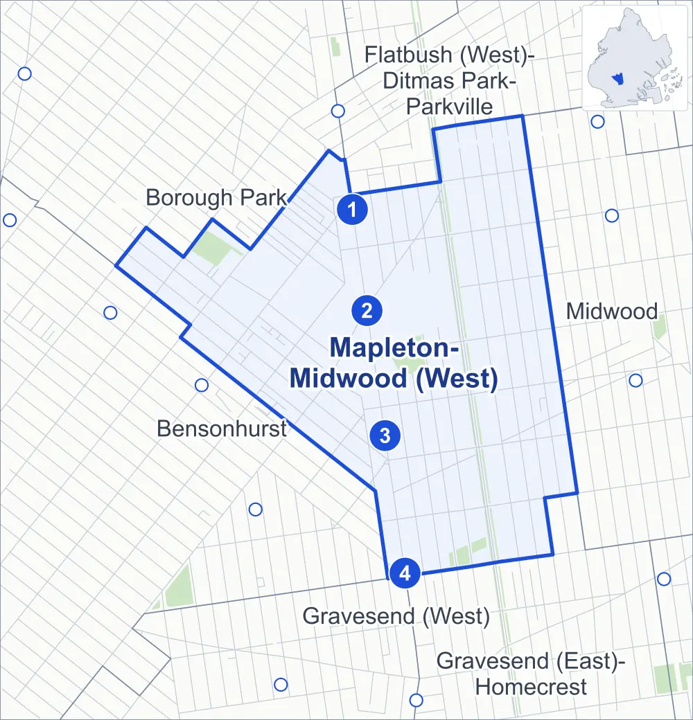
- Mapleton-Midwood (West)
- A neighboring area
- Park
- A station in the list
- Another station
Neighborhood areas and streets: NYC Department of City Planning. Parks: NYC Parks. Stations: MTA.
Neighboring areas
- Flatbush (West)-Ditmas Park-Parkville north
- Midwood east
- Gravesend (East)-Homecrest southeast
- Gravesend (West) south
- Bensonhurst southwest
- Borough Park northwest
Subway stations
- Avenue I lines F
- Bay Pkwy lines F
- Avenue N lines F
- Avenue P lines F
Getting around
Four subway stations and buses on six routes stop in or at the edge of Mapleton-Midwood (West).
- 4 subway stations
- 6 local bus routes
Local bus routes
- B6
- B8
- B9
- B11
- B68
- B90
Safety record
Between 2021 and 2025, its corners averaged fewer police-reported crashes than the average Brooklyn corner.
- 1,223 police-reported crashes at its corners
- 8.6 a corner, on average
- 10.5 the average Brooklyn corner
- 7 corners with a clean record
Signal or safety changes on City record, at 38 of its corners
- Leading pedestrian intervals
- 24
- Accessible pedestrian signals
- 19
- Turn calming
- 7
- Enhanced crossings
- 2
- Safety Improvement Projects
- 2
Camera tickets
In 2025 its corners had more school-zone speed camera tickets than red-light or bus-lane tickets.
- 17,532 red-light camera tickets at three corners
- 30,892 school-zone speed camera tickets at 14 corners
- 0 bus-lane camera tickets
- Most red-light tickets
- Ocean Parkway & Avenue I, 14,477
- Most speed tickets
- Ocean Parkway & Avenue O, 8,884
People and homes
The 2020 Census counted 39,137 residents in Mapleton-Midwood (West), about 34,900 per square mile.
- 12,878 homes, 2020 Census
- 555 homes added since April 2010, net, by City Planning's count
Half of its 4,836 residential lots hold buildings from 1930 or earlier, and 85% of them date from before 1940, by the City's tax lot records.
Parks
- Parkland
- 14.1 acres of NYC Parks property
- The largest pieces
- Friends Field (6.4 acres), Gravesend Park (5 acres) and Colonel David Marcus Playground (2.6 acres)
Streets and trees
- Trees
- 4,909 in NYC Parks' records, most often London planetree, pin oak and thornless honeylocust
- Street with the most corners
- Dahill Road, with 17 of the area's 143
- Height above sea level
- From 23 feet at Avenue M & Dahill Road to 47 feet at McDonald Avenue & Elmwood Avenue
- Honorary street names
- 2 at its corners, enacted by local law
Schools and libraries
The City lists 24 schools and two libraries in Mapleton-Midwood (West).
- Public schools
- 6
- Charter and private schools
- 18
- Libraries
- Mapleton Library and Ryder Library
Public safety
How complaints are countedIn 2025 the NYPD recorded 167 major felonies at places in Mapleton-Midwood (West).
Recorded by the NYPD at places in Mapleton-Midwood (West)
- 198 major felonies in 2024
- 611 other felonies, misdemeanors and violations in 2025
In 2025, on the streets along the edge of Mapleton-Midwood (West), the NYPD recorded another 82 major felonies. Counting the streets along its edge, in 2025 the NYPD recorded 6.4 major felonies for every thousand residents the 2020 Census counted in Mapleton-Midwood (West).
- Police precincts
- 66th (most of the area), 62nd, 70th
From January to June 2026 the NYPD recorded 95 major felonies at places in Mapleton-Midwood (West), against 79 in the same months of 2025.
Sources: the NYPD's Complaint Data Historic, updated April 28, 2026, and Complaint Data Current (Year To Date), updated July 27, 2026, on NYC Open Data. Figures to June 30, 2026.
Street corners
- 18th Avenue & 57th Street
- 18th Avenue & 58th Street
- 18th Avenue & 59th Street
- 18th Avenue & 60th Street
- 18th Avenue & 61st Street
- 47th Street & 19th Avenue
- 50th Street & Dahill Road
- 50th Street & Dahill Road at 20th Avenue
- 51st Street & 20th Avenue
- 51st Street & Dahill Road
- 52nd Street & 19th Avenue
- 52nd Street & 20th Avenue
- 52nd Street & Dahill Road
- 53rd Street & 20th Avenue
- 53rd Street & Dahill Road
- 54th Street & 19th Avenue
- 54th Street & 20th Avenue
- 57th Street & 20th Avenue
- 57th Street & 21st Avenue
- 58th Street & 19th Avenue
- 58th Street & 20th Avenue
- 58th Street & 21st Avenue
- 58th Street & Dahill Road
- 58th Street & Dahl Court
- 59th Street & 17th Avenue
- 59th Street & 19th Avenue
- 59th Street & 20th Avenue
- 59th Street & 21st Avenue
- 59th Street & 23rd Avenue
- 59th Street & Bay Parkway
- 59th Street & Dahill Road
- 60th Street & 17th Avenue
- 60th Street & 19th Avenue
- 60th Street & 20th Avenue
- 60th Street & 21st Avenue
- 60th Street & 23rd Avenue
- 60th Street & Bay Parkway
- 60th Street & Dahill Road
- 61st Street & 19th Avenue
- 61st Street & 20th Avenue
- 61st Street & 21st Avenue
- 61st Street & 23rd Avenue
- 61st Street & Bay Parkway
- 61st Street & Dahill Road
- 62nd Street & 20th Avenue
- 62nd Street & 21st Avenue
- 63rd Street & Dahill Road
- Avenue H & East 10th Street
- Avenue I & East 10th Street
- Avenue J & Bay Parkway
- Avenue J & Dahill Road
- Avenue J & East 2nd Street
- Avenue J & East 3rd Street
- Avenue J & East 4th Street
- Avenue J & East 8th Street
- Avenue J & East 9th Street
- Avenue J & East 10th Street
- Avenue K & East 8th Street
- Avenue K & East 9th Street
- Avenue K & East 10th Street
- Avenue L & East 4th Street
- Avenue L & East 7th Street
- Avenue L & East 8th Street
- Avenue L & East 9th Street
- Avenue L & East 10th Street
- Avenue M & Dahill Road
- Avenue M & East 2nd Street
- Avenue M & East 3rd Street
- Avenue M & East 4th Street
- Avenue M & East 7th Street
- Avenue M & East 8th Street
- Avenue M & East 9th Street
- Avenue M & East 10th Street
- Avenue N & East 2nd Street
- Avenue N & East 3rd Street
- Avenue N & East 4th Street
- Avenue N & East 7th Street
- Avenue N & East 8th Street
- Avenue N & East 9th Street
- Avenue N & East 10th Street
- Avenue O & Dahill Road
- Coney Island Avenue & Avenue N
- Coney Island Avenue & Cary Court
- Coney Island Avenue & Elm Avenue
- Coney Island Avenue & Locust Avenue
- Dahill Road & 19th Avenue
- Dahill Road & 23rd Avenue
- Dahill Road & 24th Avenue
- Dahill Road & 49th Road
- East 2nd Street & Avenue I
- East 2nd Street & Avenue O
- East 2nd Street & Bay Parkway
- East 2nd Street & Ryder Avenue
- East 3rd Street & Avenue I
- East 3rd Street & Avenue O
- East 3rd Street & Avenue P
- East 3rd Street & Bay Parkway
- East 3rd Street & Ryder Avenue
- East 4th Street & Avenue I
- East 4th Street & Avenue O
- East 4th Street & Avenue P
- East 4th Street & Bay Parkway
- East 4th Street & Ryder Avenue
- East 5th Street & Avenue I
- East 5th Street & Avenue J
- East 5th Street & Avenue L
- East 5th Street & Avenue M
- East 5th Street & Avenue N
- East 5th Street & Avenue O
- East 5th Street & Bay Parkway
- East 5th Street & Ryder Avenue
- East 7th Street & Avenue I
- East 7th Street & Avenue J
- East 7th Street & Avenue K
- East 7th Street & Avenue O
- East 7th Street & Avenue P
- East 7th Street & Roder Avenue
- East 8th Street & Avenue I
- East 8th Street & Avenue O
- East 8th Street & Roder Avenue
- East 9th Street & Avenue H
- East 9th Street & Avenue I
- East 9th Street & Avenue O
- East 9th Street & Roder Avenue
- East 10th Street & Roder Avenue
- McDonald Avenue & 24th Avenue
- McDonald Avenue & 65th Street
- McDonald Avenue & Avenue I
- McDonald Avenue & Avenue J
- McDonald Avenue & Avenue M
- McDonald Avenue & Avenue N
- McDonald Avenue & Avenue O
- McDonald Avenue & Avenue P
- McDonald Avenue & Bay Parkway
- McDonald Avenue & Elmwood Avenue
- McDonald Avenue & Ryder Avenue
- Ocean Parkway & Avenue I
- Ocean Parkway & Avenue J
- Ocean Parkway & Avenue L
- Ocean Parkway & Avenue M
- Ocean Parkway & Avenue N
- Ocean Parkway & Avenue O
- Ocean Parkway & Bay Parkway
How the figures above are measured: Methodology.