Tompkinsville-Stapleton-Clifton-Fox Hills
Neighborhood · Staten Island
Tompkinsville, Stapleton, Clifton and Fox Hills cover a stretch of northeastern Staten Island along Upper New York Bay.
- 0.87 square miles
- 19,027 residents, 2020 Census
- 187 street corners
- 3 Staten Island Railway stations
- 18 bus routes
Early European explorers took on fresh water at Tompkinsville, known in colonial times as the Watering Place; Governor Daniel D. Tompkins, later vice president, founded the village and in 1817 began regular ferry service to Manhattan. Stapleton was laid out in 1832 by merchant William J. Staples and Minthorne Tompkins, became known for its German-American breweries and was incorporated in 1884 as the village of Edgewater, whose old village hall still stands in Tappen Park.
Sources: Tompkinsville, Staten Island (Wikipedia); Stapleton, Staten Island (Wikipedia); St. George Historic District Designation Report (LP-1883, July 19, 1994) (NYC Landmarks Preservation Commission).
Tompkinsville-Stapleton-Clifton-Fox Hills borders three areas, and Bay Street holds more of its corners than any other street, 23 of 187.
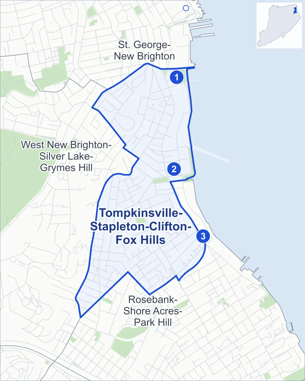
- Tompkinsville-Stapleton-Clifton-Fox Hills
- A neighboring area
- Park
- A station in the list
- Another station
Neighborhood areas and streets: NYC Department of City Planning. Parks: NYC Parks. Stations: MTA.
Neighboring areas
Staten Island Railway stations
- Tompkinsville lines SIR
- Stapleton lines SIR
- Clifton lines SIR
Getting around
The Staten Island Railway stops at Clifton, Stapleton and Tompkinsville, at or near the edge of the area, and buses on 18 routes stop in or at the edge of Tompkinsville-Stapleton-Clifton-Fox Hills.
- 3 Staten Island Railway stations
- 17 local bus routes
- 1 express bus route
Local bus routes
- S46
- S48
- S51
- S52
- S61
- S62
- S66
- S74
- S76
- S78
- S81
- S84
- S86
- S91
- S92
- S96
- S98
Express bus route
- SIM30
Safety record
Between 2021 and 2025, its corners averaged more police-reported crashes than the average Staten Island corner.
- 750 police-reported crashes at its corners
- 4.0 a corner, on average
- 2.2 the average Staten Island corner
- 33 corners with a clean record
Signal or safety changes on City record, at 32 of its corners
- Accessible pedestrian signals
- 26
- Leading pedestrian intervals
- 21
- Safety Improvement Projects
- 4
- Turn calming
- 3
- Enhanced crossings
- 3
- Barnes Dance all-way crossings
- 2
Camera tickets
In 2025 its corners had more school-zone speed camera tickets than red-light or bus-lane tickets.
- 1,523 red-light camera tickets at one corner
- 14,639 school-zone speed camera tickets at 15 corners
- 0 bus-lane camera tickets
- Most red-light tickets
- Bay Street & Hannah Street, 1,523
- Most speed tickets
- Bay Street & Swan Street, 4,675
People and homes
The 2020 Census counted 19,027 residents in Tompkinsville-Stapleton-Clifton-Fox Hills, about 21,900 per square mile.
- 6,801 homes, 2020 Census
- 1,148 homes added since April 2010, net, by City Planning's count
Half of its 2,641 residential lots hold buildings from 1930 or earlier, and 59% of them date from before 1940, by the City's tax lot records.
NYCHA development
NYCHA's Stapleton development lies wholly or partly within Tompkinsville-Stapleton-Clifton-Fox Hills.
Parks and landmarks
- Parkland
- 9.8 acres of NYC Parks property
- The largest pieces
- Rev. Dr. Maggie Howard Playground (4.1 acres), Stapleton Esplanade (3.5 acres) and Tappen Park (1.8 acres)
- Designated landmarks
- The Edgewater Village Hall, the Staten Island Savings Bank Building, the Audre Lorde Residence and the Tompkinsville (Joseph H. Lyons) Pool, among others
- Historic district
- St. Paul's Avenue-Stapleton Heights Historic District, wholly or partly within Tompkinsville-Stapleton-Clifton-Fox Hills
Streets and trees
- Trees
- 2,806 in NYC Parks' records, most often London planetree, Japanese flowering cherry and Japanese zelkova
- Street with the most corners
- Bay Street, with 23 of the area's 187
- Height above sea level
- From 7 feet at Water Street & Beach Street to 214 feet at Bayview Place & Creston Place
- Honorary street names
- 25 at its corners, enacted by local law
Schools and libraries
The City lists eight schools and one library in Tompkinsville-Stapleton-Clifton-Fox Hills.
- Public schools
- 6
- Charter and private schools
- 2
- Library
- Stapleton Library
Public art
The City's public art inventory lists one work in Tompkinsville-Stapleton-Clifton-Fox Hills: The Hiker (1916).
- 1 work of public art
Public safety
How complaints are countedIn 2025 the NYPD recorded 220 major felonies at places in Tompkinsville-Stapleton-Clifton-Fox Hills.
Recorded by the NYPD at places in Tompkinsville-Stapleton-Clifton-Fox Hills
- 231 major felonies in 2024
- 2,068 other felonies, misdemeanors and violations in 2025
In 2025, on the streets along the edge of Tompkinsville-Stapleton-Clifton-Fox Hills, the NYPD recorded another 70 major felonies. Counting the streets along its edge, in 2025 the NYPD recorded 15.2 major felonies for every thousand residents the 2020 Census counted in Tompkinsville-Stapleton-Clifton-Fox Hills.
- Police precinct
- 120th
From January to June 2026 the NYPD recorded 102 major felonies at places in Tompkinsville-Stapleton-Clifton-Fox Hills, against 107 in the same months of 2025.
Sources: the NYPD's Complaint Data Historic, updated April 28, 2026, and Complaint Data Current (Year To Date), updated July 27, 2026, on NYC Open Data. Figures to June 30, 2026.
Street corners
- Avon Place & Edgar Terrace
- Avon Place & Willis Avenue
- Bay Street & Baltic Street
- Bay Street & Broad Street
- Bay Street & Canal Street
- Bay Street & Clinton Street
- Bay Street & Congress Street
- Bay Street & Cross Street
- Bay Street & Dock Street
- Bay Street & Grant Street
- Bay Street & Hannah Street
- Bay Street & Merivale Lane
- Bay Street & Minthorne Street
- Bay Street & Prospect Street
- Bay Street & Sands Street
- Bay Street & St Julian Place
- Bay Street & Swan Street
- Bay Street & Thompson Street
- Bay Street & Townsend Avenue
- Bay Street & Union Place
- Bay Street & Van Duzer Street Extension
- Bay Street & Victory Boulevard Footbridge
- Bay Street & Water Street
- Bay Street & Wave Street
- Bay Street & William Street
- Bayview Place & Creston Place
- Beach Street & Union Place
- Boyd Street & Cedar Street
- Boyd Street & Court Street
- Boyd Street & Hygeia Place
- Boyd Street & Tappen Court
- Brewster Street & William Street
- Broad Street & Brownell Street
- Broad Street & Cedar Street
- Broad Street & Gordon Street
- Broad Street & Quinn Street
- Broad Street & Wright Street
- Canal Street & Broad Street
- Canal Street & Wright Street
- Cebra Avenue & Catlin Avenue
- Cebra Avenue & Chester Place
- Cebra Avenue & Rosewood Place
- Cedar Street & Adele Court
- Cedar Street & Hudson Street
- Clinton Street & Brewster Street
- Coursen Place & Coursen Court
- Coursen Place & Dix Place
- Coursen Place & Pine Place
- Coursen Place & Pleasant Court
- Coursen Place & Pleasant Place
- Court Street & Grove Street
- Court Street & Tompkins Place
- Edgar Terrace & Fiedler Avenue
- Fairway Avenue & Park Hill Court
- Fairway Avenue & Park Hill Lane
- Front Street & Canal Street
- Front Street & Hannah Street
- Front Street & Hudson View Loop
- Front Street & Navy Pier Court
- Front Street & Prospect Street
- Front Street & Water Street
- Front Street & Wave Street
- Gordon Street & Frean Street
- Gordon Street & Gray Street
- Gordon Street & Grove Street
- Gordon Street & Hudson Street
- Gordon Street & Laurel Avenue
- Gordon Street & Purroy Place
- Gordon Street & Warren Street
- Grant Street & Dulancey Court
- Greenfield Avenue & Amazon Court
- Greenfield Avenue & Del Ray Court
- Greenfield Avenue & Flower Court
- Greenfield Avenue & Greenfield Court
- Greenfield Avenue & Merivale Lane
- Greenfield Avenue & Opus Court
- Greenfield Avenue & Thistle Court
- Grove Street & Hygeia Place
- Hannah Street & Murray Hulbert Avenue
- Harrison Street & Brownell Street
- Hudson Street & Gray Street
- Irving Place & Delford Street
- Irving Place & Hardy Street
- Jackson Street & Taxter Place
- Kimberly Lane & Fairway Avenue
- Kimberly Lane & Sandra Lane
- Nixon Avenue & Ward Avenue
- Norwood Avenue & Errington Place
- Norwood Avenue & Talbot Place
- Osgood Avenue & Gordon Street
- Osgood Avenue & Park Hill Avenue
- Osgood Avenue & Wiederer Place
- Park Hill Avenue & Park Hill Court
- Park Hill Avenue & Park Hill Lane
- Park Hill Circle & Park Hill Lane
- Prince Street & Hardy Street
- Prince Street & Mickardan Court
- Prince Street & Wiederer Place
- Richmond Road & Van Duzer Street
- Roff Street & Delford Street
- Roff Street & Hardy Street
- St Pauls Avenue & Cebra Avenue
- St Pauls Avenue & Clinton Street
- St Pauls Avenue & Grant Street
- St Pauls Avenue & Hannah Street
- St Pauls Avenue & Paxton Street
- St Pauls Avenue & Swan Street
- St Pauls Avenue & Taxter Place
- Susan Court & Thelma Court
- Tappen Court & Cedar Street
- Targee Street & Broad Street
- Targee Street & Frean Street
- Targee Street & Irving Place
- Targee Street & Laurel Avenue
- Targee Street & Metcalfe Street
- Targee Street & Osgood Avenue
- Targee Street & Purroy Place
- Targee Street & Roff Street
- Targee Street & Van Duzer Street
- Targee Street & Vanderbilt Avenue
- Targee Street & Waverly Place
- Targee Street & Young Street
- Tompkins Avenue & Canal Street
- Tompkins Avenue & Greenfield Avenue
- Tompkins Avenue & Hill Street
- Tompkins Avenue & Kimberly Lane
- Tompkins Avenue & Kristen Court
- Tompkins Avenue & Norwood Avenue
- Tompkins Avenue & Susan Court
- Tompkins Avenue & Thelma Court
- Tompkins Avenue & Tompkins Street
- Tompkins Avenue & Townsend Avenue
- Tompkins Avenue & Vanderbilt Avenue
- Tompkins Circle & Fiedler Avenue
- Tompkins Circle & Pavillion Hill Terrace
- Tompkins Street & Brownell Street
- Tompkins Street & Quinn Street
- Van Duzer Street & Baltic Street
- Van Duzer Street & Clinton Street
- Van Duzer Street & Cornell Place
- Van Duzer Street & Grant Street
- Van Duzer Street & Hannah Street
- Van Duzer Street & Margo Loop
- Van Duzer Street & Maxie Court
- Van Duzer Street & Prospect Street
- Van Duzer Street & Roff Street
- Van Duzer Street & Sands Street
- Van Duzer Street & Smith Terrace
- Van Duzer Street & St Pauls Avenue
- Van Duzer Street & Swan Street
- Van Duzer Street & Van Duzer Street Extension
- Van Duzer Street & Waverly Place
- Van Duzer Street & William Street
- Van Duzer Street Extension & St Julian Place
- Vanderbilt Avenue & Cornell Place
- Vanderbilt Avenue & Errington Place
- Vanderbilt Avenue & Hamilton Street
- Vanderbilt Avenue & Hillside Avenue
- Vanderbilt Avenue & Irving Place
- Vanderbilt Avenue & Nunley Court
- Vanderbilt Avenue & Osgood Avenue
- Vanderbilt Avenue & Park Hill Court
- Vanderbilt Avenue & Park Hill Lane
- Vanderbilt Avenue & Pine Place
- Vanderbilt Avenue & Pleasant Place
- Vanderbilt Avenue & Prince Street
- Vanderbilt Avenue & Richmond University Medical Center Driveway
- Vanderbilt Avenue & Talbot Place
- Victory Boulevard & Avon Place
- Victory Boulevard & Bay Street Landing
- Victory Boulevard & Murray Hulbert Avenue
- Victory Boulevard & Pike Street
- Victory Boulevard & Van Duzer Street
- Victory Boulevard & Westervelt Avenue
- Ward Avenue & Avon Place
- Ward Avenue & Bayview Place
- Ward Avenue & Tompkins Circle
- Warren Street & Fulton Street
- Warren Street & Hill Street
- Warren Street & Laurel Avenue
- Water Street & Beach Street
- Water Street & Canal Street
- Wave Street & Sands Street
- Waverly Place & Wiederer Place
- Willis Avenue & Fiedler Avenue
- Wright Street & Boyd Street
- Wright Street & Thompson Street
How the figures above are measured: Methodology.