St. George-New Brighton
Neighborhood · Staten Island
St. George and New Brighton occupy the northeastern tip of Staten Island, where the Kill Van Kull meets Upper New York Bay.
- 0.95 square miles
- 20,549 residents, 2020 Census
- 184 street corners
- 1 Staten Island Railway station
- 22 bus routes
New Brighton began in 1834 and 1835, when Manhattan developer Thomas E. Davis bought the land and planned a summer retreat, and St. George was named in the 1880s for George Law, who made land available for a new ferry and rail terminal. Since Borough Hall was completed in 1906 the area has served as the island's civic center, home to the Staten Island Ferry terminal, the Staten Island Museum and a historic district of late-19th-century houses designated in 1994.
Sources: St. George, Staten Island (Wikipedia); New Brighton, Staten Island (Wikipedia); St. George Historic District Designation Report (LP-1883, July 19, 1994) (NYC Landmarks Preservation Commission).
St. George-New Brighton borders three areas, and Richmond Terrace holds more of its corners than any other street, 16 of 184.
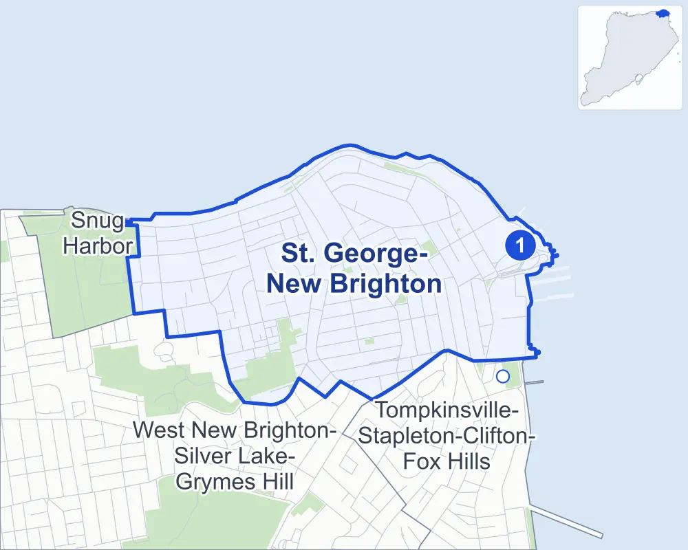
- St. George-New Brighton
- A neighboring area
- Park
- A station in the list
- Another station
Neighborhood areas and streets: NYC Department of City Planning. Parks: NYC Parks. Stations: MTA.
Neighboring areas
- Tompkinsville-Stapleton-Clifton-Fox Hills southeast
- West New Brighton-Silver Lake-Grymes Hill southwest
- Snug Harbor west
Staten Island Railway stations
- St George lines SIR accessible
Getting around
The Staten Island Railway stops at St George, and buses on 22 routes stop in or at the edge of St. George-New Brighton.
- 1 Staten Island Railway station
- 1 listed by the MTA as fully accessible
- 22 local bus routes
Local bus routes
- S40
- S42
- S44
- S46
- S48
- S51
- S52
- S61
- S62
- S66
- S74
- S76
- S78
- S81
- S84
- S86
- S90
- S91
- S92
- S94
- S96
- S98
Safety record
Between 2021 and 2025, its corners averaged more police-reported crashes than the average Staten Island corner.
- 688 police-reported crashes at its corners
- 3.7 a corner, on average
- 2.2 the average Staten Island corner
- 45 corners with a clean record
Signal or safety changes on City record, at 18 of its corners
- Accessible pedestrian signals
- 15
- Leading pedestrian intervals
- 8
- Turn calming
- 1
- Barnes Dance all-way crossings
- 1
- Safety Improvement Projects
- 1
Camera tickets
In 2025 its corners had more school-zone speed camera tickets than red-light or bus-lane tickets.
- 0 red-light camera tickets
- 8,279 school-zone speed camera tickets at 12 corners
- 0 bus-lane camera tickets
- Most speed tickets
- Lafayette Avenue & Alden Place, 2,909
People and homes
The 2020 Census counted 20,549 residents in St. George-New Brighton, about 21,600 per square mile.
- 8,430 homes, 2020 Census
- 464 homes added since April 2010, net, by City Planning's count
Half of its 2,437 residential lots hold buildings from 1920 or earlier, and 70% of them date from before 1940, by the City's tax lot records.
NYCHA developments
NYCHA's Cassidy-Lafayette development lies wholly or partly within St. George-New Brighton, as does one more that NYCHA names by a building's address.
Parks and landmarks
- Parkland
- 26.7 acres of NYC Parks property
- The largest pieces
- Jones Woods Park (16.9 acres), Cottages Hill New Brighton Park (2.2 acres) and Mahoney Playground (2.1 acres)
- Designated landmarks
- The Richmond County Courthouse, the Staten Island Borough Hall, the Christ Church and Parish House (including Cloisters) and the Staten Island Depot Office Building, among others
- Historic district
- St. George / New Brighton Historic District, wholly or partly within St. George-New Brighton
Streets and trees
- Trees
- 2,684 in NYC Parks' records, most often London planetree, thornless honeylocust and Norway maple
- Street with the most corners
- Richmond Terrace, with 16 of the area's 184
- Height above sea level
- From 7 feet at Bay Street Landing & The Promenade to 232 feet at Franklin Avenue & Arnold Street
- Honorary street names
- 40 at its corners, enacted by local law
Schools and libraries
The City lists eight schools and one library in St. George-New Brighton.
- Public schools
- 8
- Library
- St. George Library Center
Public art
The City's public art inventory lists four works in St. George-New Brighton, among them Major Clarence T. Barrett Memorial (1915), Staten Island War Memorial (1920) and Frank D. Paulo (1985).
- 4 works of public art
Public safety
How complaints are countedIn 2025 the NYPD recorded 225 major felonies at places in St. George-New Brighton.
Recorded by the NYPD at places in St. George-New Brighton
- 287 major felonies in 2024 62 fewer in 2025
- 1,844 other felonies, misdemeanors and violations in 2025
In 2025, on the streets along the edge of St. George-New Brighton, the NYPD recorded another 28 major felonies. Counting the streets along its edge, in 2025 the NYPD recorded 12.3 major felonies for every thousand residents the 2020 Census counted in St. George-New Brighton.
- Police precinct
- 120th
From January to June 2026 the NYPD recorded 91 major felonies at places in St. George-New Brighton, against 109 in the same months of 2025.
Sources: the NYPD's Complaint Data Historic, updated April 28, 2026, and Complaint Data Current (Year To Date), updated July 27, 2026, on NYC Open Data. Figures to June 30, 2026.
Street corners
- Arnold Street & Crystal Lane
- Arnold Street & Pendleton Place
- Arnold Street & Sumner Place
- Bay Street & Borough Place
- Bay Street & Central Avenue
- Bay Street & Ferry Terminal Drive
- Bay Street & Hyatt Street
- Bay Street & Nick Laporte Place
- Bay Street & Slosson Terrace
- Bay Street Landing & The Promenade
- Belmont Place & Fort Place
- Belmont Place & Vine Street
- Belmont Place & Wall Street
- Benziger Avenue & Bismark Avenue
- Benziger Avenue & Daniel Low Terrace
- Benziger Avenue & Monroe Avenue
- Benziger Avenue & Sherman Avenue
- Bismark Avenue & Crescent Avenue
- Bismark Avenue & Hendricks Avenue
- Bismark Avenue & Layton Avenue
- Bismark Avenue & Scribner Avenue
- Bismark Avenue & Taft Avenue
- Borough Place & Staten Island Ferry Maintenance Facility Driveway
- Borough Place & Staten Island Ferry Terminal Pedestrian Overpass
- Borough Place & The Promenade
- Brighton Avenue & Butler Terrace
- Brighton Avenue & Ely Street
- Brighton Avenue & Glen Avenue
- Brighton Avenue & Lafayette Avenue
- Brighton Avenue & Pine Street
- Brighton Avenue & Sumner Place
- Brighton Avenue & Trumbull Place
- Brighton Avenue & York Avenue
- Brook Street & Fremont Street
- Brook Street & Pike Street
- Carroll Place & Nicholas Street
- Carroll Place & St Peters Place
- Cassidy Place & Tysen Street
- Castleton Avenue & Brook Street
- Central Avenue & Hyatt Street
- Central Avenue & Slosson Terrace
- Chapel Road & Fillmore Street
- Clinton Avenue & Cassidy Place
- Clinton Avenue & Van Buren Street
- Corson Avenue & Daniel Low Terrace
- Corson Avenue & Ely Street
- Corson Avenue & Fremont Street
- Corson Avenue & Pine Street
- Corson Avenue & Sherman Avenue
- Crescent Avenue & Beechwood Avenue
- Daniel Low Terrace & Belmont Place
- Daniel Low Terrace & Crescent Avenue
- Daniel Low Terrace & Fort Hill Circle (north)
- Daniel Low Terrace & Fort Hill Circle (south)
- Daniel Low Terrace & Fort Place
- Daniel Low Terrace & Vine Street
- East Buchanan Street & Northview Court
- East Buchanan Street & York Terrace
- Ferry Terminal Drive & Staten Island Ferry Terminal Pedestrian Overpass
- Ferry Terminal Viaduct & Ferry Terminal Drive
- Ferry Terminal Viaduct & Staten Island Ferry Terminal Pedestrian Overpass
- Fillmore Street & Clinton Avenue
- Fillmore Street & Franklin Avenue
- Fillmore Street & Highview Avenue
- Fillmore Street & Lafayette Avenue
- Fillmore Street & Minerva Place
- Fillmore Street & Tysen Street
- Fillmore Street & York Avenue
- Fillmore Street & York Terrace
- Franklin Avenue & Arnold Street
- Franklin Avenue & Cassidy Place
- Franklin Avenue & Eadie Place
- Franklin Avenue & East Buchanan Street
- Franklin Avenue & Park Place
- Franklin Avenue & Pendleton Place
- Franklin Avenue & Van Buren Street
- Hamilton Avenue & Academy Place
- Hamilton Avenue & Curtis Place
- Hamilton Avenue & Daniel Low Terrace
- Hamilton Avenue & Egmont Place
- Hamilton Avenue & Phelps Place
- Hamilton Avenue & Stuyvesant Place
- Harvard Avenue & East Buchanan Street
- Harvard Avenue & Nassau Street
- Harvard Avenue & Park Place
- Henderson Avenue & Cassidy Place
- Henderson Avenue & Clinton Avenue
- Henderson Avenue & Clinton Court
- Henderson Avenue & Grace Court
- Henderson Avenue & Kirby Court
- Henderson Avenue & Lafayette Avenue
- Henderson Avenue & Tysen Street
- Hendricks Avenue & Fort Hill Park
- Hendricks Avenue & Sherman Avenue
- Highview Avenue & Eadie Place
- Highview Avenue & East Buchanan Street
- Highview Avenue & Park Place
- Jersey Street & Bank Street
- Jersey Street & Benziger Avenue
- Jersey Street & Brighton Avenue
- Jersey Street & Carlyle Street
- Jersey Street & Corson Avenue
- Jersey Street & Crescent Avenue
- Jersey Street & Hendricks Avenue
- Jersey Street & Layton Avenue
- Jersey Street & Pauw Street
- Jersey Street & Stanley Avenue
- Jersey Street & Taft Avenue
- Jersey Street & Winter Avenue
- Kirby Court & Cortelyou Place
- Lafayette Avenue & Alden Place
- Lafayette Avenue & Cassidy Place
- Lafayette Avenue & Cortelyou Place
- Lafayette Avenue & Van Buren Street
- Lafayette Avenue & West Buchanan Street
- Monroe Avenue & Fort Place
- Montgomery Avenue & Fort Place
- Prospect Avenue & Clinton Court
- Prospect Avenue & Clyde Place
- Prospect Avenue & Duane Court
- Prospect Avenue & Ellicott Place
- Prospect Avenue & Franklin Avenue
- Prospect Avenue & Harvard Avenue
- Prospect Avenue & Lafayette Avenue
- Prospect Avenue & Pendleton Place
- Prospect Avenue & Sumner Place
- Prospect Avenue & York Avenue
- Richmond Terrace & Bay Street
- Richmond Terrace & Clinton Avenue
- Richmond Terrace & Ferry Terminal Drive
- Richmond Terrace & Franklin Avenue
- Richmond Terrace & Hamilton Avenue
- Richmond Terrace & Jersey Street
- Richmond Terrace & Lafayette Avenue
- Richmond Terrace & Nicholas Street
- Richmond Terrace & Schuyler Street
- Richmond Terrace & Snug Harbor Cultural Center Driveway
- Richmond Terrace & St Peters Place
- Richmond Terrace & Stuyvesant Place
- Richmond Terrace & Tysen Street
- Richmond Terrace & Wall Street
- Richmond Terrace & Westervelt Avenue
- Richmond Terrace & York Avenue
- Robert Lane & Crystal Lane
- St Marks Place & Fort Place
- St Marks Place & Hamilton Avenue
- St Marks Place & Hyatt Street
- St Marks Place & Nicholas Street
- St Marks Place & Wall Street
- St Marks Place & Westervelt Avenue
- Stuyvesant Place & Hyatt Street
- Stuyvesant Place & Schuyler Street
- Stuyvesant Place & Wall Street
- Tysen Street & Gordon Place
- Van Buren Street & Minerva Place
- Victory Boulevard & Bay Street
- Victory Boulevard & Bay Street at St Marks Place
- Victory Boulevard & Brook Street
- Victory Boulevard & Corson Avenue
- Victory Boulevard & Fremont Street
- Victory Boulevard & Jersey Street
- Victory Boulevard & Victory Boulevard Footbridge
- Wall Street & Academy Place
- Westervelt Avenue & Benziger Avenue
- Westervelt Avenue & Brook Street
- Westervelt Avenue & Carroll Place
- Westervelt Avenue & Cleveland Street
- Westervelt Avenue & Corson Avenue
- Westervelt Avenue & Crescent Avenue
- Westervelt Avenue & Curtis Place
- Westervelt Avenue & Hamilton Avenue
- Westervelt Avenue & Hendricks Avenue
- Westervelt Avenue & Layton Avenue
- Westervelt Avenue & Scribner Avenue
- Westervelt Avenue & Taft Avenue
- Westervelt Avenue & Winter Avenue
- Winter Avenue & Bismark Avenue
- York Avenue & Arnold Street
- York Avenue & Carlyle Street
- York Avenue & East Buchanan Street
- York Avenue & Park Place
- York Avenue & Pauw Street
- York Avenue & Van Buren Street
- York Avenue & Van Tuyl Street
How the figures above are measured: Methodology.