New Springville-Willowbrook-Bulls Head-Travis
Neighborhood · Staten Island
New Springville-Willowbrook-Bulls Head-Travis stretches across west-central Staten Island from Bulls Head and part of Willowbrook through New Springville, Heartland Village, Bloomfield and Chelsea to Travis.
- 7.51 square miles
- 42,871 residents, 2020 Census
- 503 street corners
- 26 bus routes
Bulls Head is named for an 18th-century tavern that displayed a bull's-head sign, and New Springville for local freshwater springs; both stayed largely rural until the Verrazzano-Narrows Bridge opened in 1964. Travis, named for Jacob Travis, was called Linoleumville after the nation's first linoleum factory opened there in 1873, and its Fourth of July parade has marched along Victory Boulevard since 1911. The plain 1849 Asbury Methodist Church on Richmond Avenue is a city landmark.
Sources: History (Travis Fourth of July Celebration Committee); Asbury Methodist Church Designation Report (LP-0364, March 19, 1968) (NYC Landmarks Preservation Commission); Bulls Head, Staten Island (Wikipedia); New Springville, Staten Island (Wikipedia).
New Springville-Willowbrook-Bulls Head-Travis borders five areas, and Victory Boulevard holds more of its corners than any other street, 43 of 503.
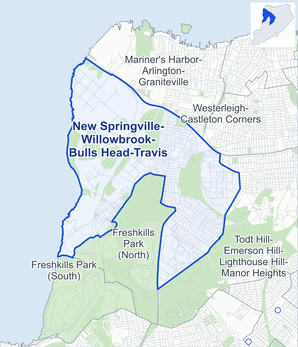
- New Springville-Willowbrook-Bulls Head-Travis
- A neighboring area
- Park
- Another station
Neighborhood areas and streets: NYC Department of City Planning. Parks: NYC Parks. Stations: MTA.
Neighboring areas
Getting around
Buses on 26 routes stop in or at the edge of New Springville-Willowbrook-Bulls Head-Travis.
- 16 local bus routes
- 10 express bus routes
Local bus routes
- S40
- S44
- S46
- S55
- S56
- S59
- S61
- S62
- S79-SBS
- S89
- S90
- S91
- S92
- S93
- S94
- S96
Express bus routes
- SIM2
- SIM4
- SIM4C
- SIM8
- SIM25
- SIM26
- SIM31
- SIM32
- SIM33
- SIM33C
Safety record
Between 2021 and 2025, its corners averaged more police-reported crashes than the average Staten Island corner.
- 1,406 police-reported crashes at its corners
- 2.8 a corner, on average
- 2.2 the average Staten Island corner
- 263 corners with a clean record
Signal or safety changes on City record, at 58 of its corners
- Accessible pedestrian signals
- 56
- Leading pedestrian intervals
- 9
- Turn calming
- 4
- Safety Improvement Projects
- 1
Camera tickets
In 2025 its corners had more school-zone speed camera tickets than red-light or bus-lane tickets.
- 17,451 red-light camera tickets at seven corners
- 26,322 school-zone speed camera tickets at 18 corners
- 0 bus-lane camera tickets
- Most red-light tickets
- Victory Boulevard & Morani Street, 7,142
- Most speed tickets
- Richmond Hill Road & Merrymount Street, 6,025
People and homes
The 2020 Census counted 42,871 residents in New Springville-Willowbrook-Bulls Head-Travis, about 5,700 per square mile.
- 16,117 homes, 2020 Census
- 553 homes added since April 2010, net, by City Planning's count
Half of its 8,034 residential lots hold buildings from 1980 or earlier, and 3% of them date from before 1940, by the City's tax lot records.
Parks and landmarks
- Parkland
- 831.7 acres of NYC Parks property
- The largest pieces
- Willowbrook Park (214.9 acres), Staten Island Industrial Park (210.9 acres) and Saw Mill Creek Marsh (181.9 acres)
- Designated landmarks
- The Decker Farmhouse and the Asbury Methodist Church
Streets and trees
- Trees
- 8,716 in NYC Parks' records, most often Callery pear, green ash and red maple
- Street with the most corners
- Victory Boulevard, with 43 of the area's 503
- Height above sea level
- From 3 feet at 3rd Street & 2nd Avenue to 181 feet at Forest Hill Road & Rockland Avenue
- Honorary street names
- 25 at its corners, enacted by local law
Schools
The City lists 20 schools in New Springville-Willowbrook-Bulls Head-Travis.
- Public schools
- 11
- Charter and private schools
- 9
Public safety
How complaints are countedIn 2025 the NYPD recorded 199 major felonies at places in New Springville-Willowbrook-Bulls Head-Travis.
Recorded by the NYPD at places in New Springville-Willowbrook-Bulls Head-Travis
- 203 major felonies in 2024
- 1,054 other felonies, misdemeanors and violations in 2025
- Police precinct
- 121st
From January to June 2026 the NYPD recorded 102 major felonies at places in New Springville-Willowbrook-Bulls Head-Travis, against 99 in the same months of 2025.
Sources: the NYPD's Complaint Data Historic, updated April 28, 2026, and Complaint Data Current (Year To Date), updated July 27, 2026, on NYC Open Data. Figures to June 30, 2026.
Street corners
- 1st Avenue & B Street
- 1st Avenue & C Street
- 1st Avenue & College of Staten Island Driveway (north)
- 1st Avenue & College of Staten Island Driveway (south)
- 3rd Street & 2nd Avenue
- 3rd Street & 4th Avenue
- 3rd Street & 6th Avenue
- 4th Avenue & 7th Street
- 5th Street & 2nd Avenue
- 5th Street & 4th Avenue
- 5th Street & 6th Avenue
- 5th Street & 8th Avenue
- 5th Street & Bloomfield Road
- 6th Avenue & 7th Street
- A Street & 1st Avenue
- A Street & 2nd Avenue
- A Street & 3rd Avenue
- A Street & 4th Avenue
- A Street & College of Staten Island Driveway
- Agrig Court & Daffodil Lane
- Agrig Court & Gardenia Lane
- Akron Street & Debbie Street
- Akron Street & Saybrook Street
- Alberta Avenue & Dean Avenue
- Amsterdam Avenue & Carnegie Avenue
- Amsterdam Place & Freedom Avenue
- Amsterdam Place & Toddy Avenue
- Amy Court & Gregory Lane
- Arielle Lane & Gregory Lane
- Arlene Street & Amsterdam Avenue
- Arlene Street & Bishop Patrick Ahern High School Driveway
- Arlene Street & Carnegie Avenue
- Arlene Street & Commerce Street
- Arlene Street & Dawson Circle
- Arlene Street & Dawson Circle at Dawson Court
- Arlene Street & Fahy Avenue
- Arlene Street & Forest Street
- Arlene Street & Kirshon Avenue
- Arlene Street & Lander Avenue
- Arlene Street & Merrill Avenue
- Arlene Street & Paulding Avenue
- Arlene Street & Roman Avenue
- Arlene Street & Sideview Avenue
- Arlene Street & Sierra Court
- Arlene Street & Signs Road
- Arlene Street & Sommer Avenue
- Ashworth Avenue & Carpenter Avenue
- Ashworth Avenue & Gina Court
- Ashworth Avenue & Greenway Avenue
- Ashworth Avenue & Grissom Avenue
- Ashworth Avenue & Latourette Lane
- Ashworth Avenue & Lovell Avenue
- Ashworth Avenue & Shepard Avenue
- Ashworth Avenue & Shirra Avenue
- B Street & 3rd Avenue
- Baron Boulevard & Latimer Avenue
- Baron Boulevard & Wakefield Avenue
- Belmar Drive East & Belmar Drive West
- Berglund Avenue & Firth Road
- Berglund Avenue & Paulding Avenue
- Berglund Avenue & Plank Road
- Bowdoin Street & Fraser Street
- Braisted Avenue & Denker Place
- Braisted Avenue & Evans Street
- Braisted Avenue & Nehring Avenue
- Bridgetown Street & Bangor Street
- Bridgetown Street & Furness Place
- Burke Avenue & Mildred Avenue
- C Street & 3rd Avenue
- Cannon Avenue & Leroy Street
- Cannon Avenue & Prices Lane
- Canon Drive & Arielle Lane
- Canterbury Avenue & Darcey Avenue
- Carpenter Avenue & Slayton Avenue
- Chelsea Road & Bloomfield Avenue
- Chelsea Road & Bloomfield Road
- Chelsea Road & Edward Curry Avenue
- Chelsea Road & River Road
- Christopher Lane & Akron Street
- Christopher Lane & Croton Place
- Christopher Lane & Dr M L King Jr Expressway
- Christopher Lane & Yona Avenue
- Church Avenue & Saratoga Way
- Church Avenue & Temple Court
- Clifton Street & Jones Street
- Commerce Street & Fieldstone Road (north-west)
- Commerce Street & Fieldstone Road (south-east)
- Commerce Street & Nadal Place
- Commerce Street & Oliver Place
- Cooper Terrace & Orbit Lane
- Copley Street & Fraser Street
- Country Drive East & Country Drive South
- Country Drive West & Country Drive North
- Country Drive West & Country Drive South
- Country Drive West & Stratford Court
- D Street & 3rd Avenue
- Dawson Circle & Carnegie Avenue
- Denker Place & Edward Court
- Denker Place & Teri Court
- Devon Loop & Elmwood Park Drive
- Dr M L King Jr Expressway & Victory Boulevard
- Draper Place & Knapp Street
- East Service Road & Nursery Path
- East Service Road & West Shore Expressway
- Elmwood Park Drive & Donna Court
- Elson Street & Caswell Lane
- Elson Street & Gauldy Avenue
- Elson Street & Hirsch Lane
- Elson Street & Leigh Avenue
- Essex Drive & Chesterfield Lane
- Essex Drive & Daniella Court
- Essex Drive & Mercury Lane
- Essex Drive & Wellington Court
- Essex Drive & Westport Street
- Executive Way & D Street
- Fahy Avenue & Brad Lane
- Fahy Avenue & Felton Street
- Fahy Avenue & Lamberts Lane
- Fahy Avenue & Longdale Street
- Felton Street & Aye Court
- Felton Street & Caswell Lane
- Felton Street & Gauldy Avenue
- Felton Street & Leigh Avenue
- Ferndale Avenue & Ferndale Court
- Fieldstone Road & Elson Street
- Fieldstone Road & Oliver Place
- Firth Road & Plank Road
- Forest Avenue & Gulf Avenue
- Forest Hill Road & Alaska Place
- Forest Hill Road & Boone Street
- Forest Hill Road & D Street
- Forest Hill Road & Dorothy Street
- Forest Hill Road & Independence Avenue
- Forest Hill Road & Institute For Basic Research Driveway
- Forest Hill Road & Leason Place
- Forest Hill Road & Norwich Street
- Forest Hill Road & Pilcher Street
- Forest Hill Road & Richmond Hill Road
- Forest Hill Road & Rockland Avenue
- Forest Hill Road & Steers Street
- Forest Hill Road & Travis Avenue
- Forest Hill Road & Uxbridge Street
- Forest Street & Jones Street
- Forest Street & Lisa Place
- Freedom Avenue & Doe Court
- Freedom Avenue & Knapp Street
- Freedom Avenue & Rivington Avenue
- Freedom Avenue & Sleepy Hollow Road
- Gary Court & Leona Street
- Gary Place & Carreau Avenue
- Gary Place & Toddy Avenue
- Gauldy Avenue & Bee Court
- Gauldy Avenue & Kingsbridge Avenue
- Gauldy Avenue & Longdale Street
- Glen Street & Cannon Avenue
- Glen Street & Edward Curry Avenue
- Glen Street & Lois Lane (north-east)
- Glen Street & Lois Lane (south-west)
- Glen Street & Melvin Avenue
- Glen Street & West Shore Expressway
- Glen Street & West Shore Expressway (Exit 9)
- Glen Street & Wild Avenue
- Glenn Road & Amy Lane
- Glenn Road & Carpenter Avenue
- Glenn Road & Slayton Avenue
- Goller Place & Croft Place
- Graham Avenue & Fieldstone Road
- Graham Avenue & Paulding Avenue
- Graham Avenue & Sommer Avenue
- Greenway Avenue & Conrad Avenue
- Gulf Avenue & Bloomfield Avenue
- Gulf Avenue & Edward Curry Avenue
- Gulf Avenue & Staten Island Expressway
- Gulf Avenue & Staten Island Expressway (Exit 4)
- Gulf Avenue & Western Avenue
- Hawthorne Avenue & Darcey Avenue
- Hawthorne Avenue & Dreyer Avenue
- Hillman Avenue & Jardine Avenue
- Hillman Avenue & Leggett Place
- Hillman Avenue & Morgan Lane
- Hillman Avenue & Renee Place
- Jardine Avenue & Leggett Place
- Jardine Avenue & Morgan Lane
- Jennifer Place & Akron Street
- Jennifer Place & Debbie Street
- Kelly Boulevard & Braisted Avenue
- Kelly Boulevard & McVeigh Avenue
- Kirshon Avenue & Elson Street
- Kirshon Avenue & May Avenue
- Kirshon Avenue & Renee Place
- Kirshon Avenue & Seldin Avenue
- Klondike Avenue & Bridgetown Street
- Klondike Avenue & Denker Place
- Klondike Avenue & Fraser Street
- Klondike Avenue & Kelly Boulevard
- Klondike Avenue & Lewiston Street
- Klondike Avenue & Merrymount Street
- Klondike Avenue & Nehring Avenue
- Klondike Avenue & Radford Street
- Klondike Avenue & Steinway Avenue
- Klondike Avenue & Vassar Street
- Lamberts Lane & Elson Street
- Lamberts Lane & Globe Avenue
- Lamberts Lane & Kingsbridge Avenue
- Lamberts Lane & Longdale Street
- Lamberts Lane & Pyramid Court
- Lamberts Lane & Seldin Avenue
- Lamberts Lane & Staten Island Expressway
- Lamberts Lane & Staten Island Expressway at Astor Avenue
- Lamped Loop & Agrig Court
- Lamped Loop & Daffodil Lane (north-west)
- Lamped Loop & Daffodil Lane (south-east)
- Lamped Loop & Gardenia Lane (north-west)
- Lamped Loop & Gardenia Lane (south-east)
- Lander Avenue & Elson Street
- Lander Avenue & Hirsch Lane
- Lander Avenue & Renee Place
- Latimer Avenue & Shenandoah Avenue
- Lewiston Street & Bangor Street
- Lewiston Street & Furness Place
- Loop Road & 1st Avenue
- Loop Road & 1st Avenue at D Street
- Loop Road & A Street
- Loop Road & A Street at College of Staten Island Driveway
- Loop Road & D Street
- Lovell Avenue & Shirra Avenue
- Marsh Avenue & Elmwood Park Drive
- Marsh Avenue & Platinum Avenue
- Marsh Avenue & Staten Island Mall Drive (north)
- Marsh Avenue & Staten Island Mall Drive (south)
- Marsh Avenue & Westport Street
- Marsh Avenue & Windham Loop
- McDivitt Avenue & Gina Court
- McDivitt Avenue & Shirra Avenue
- McVeigh Avenue & Denker Place
- McVeigh Avenue & Evans Street
- McVeigh Avenue & Nehring Avenue
- Melvin Avenue & Fresh Kills Park Schmul Path
- Meredith Avenue & Cannon Avenue
- Meredith Avenue & Egrit Court
- Merrill Avenue & Bishop Patrick Ahern High School Driveway
- Merrill Avenue & Danny Court
- Merrill Avenue & Firth Road
- Merrill Avenue & Graham Avenue
- Merrill Avenue & Hillman Avenue
- Merrymount Street & Saxon Avenue
- Merrymount Street & Shiloh Street
- Monahan Avenue & Beard Street
- Monahan Avenue & Denker Place
- Monahan Avenue & Evans Street
- Monahan Avenue & Kelly Boulevard
- Monahan Avenue & Lewiston Street
- Monarch Court & Dovetree Lane
- Monarch Court & Persimmon Lane
- Monarch Court & Sweetgum Lane
- Morani Street & Debbie Street
- Morani Street & Jennifer Place
- Morani Street & Leona Street
- Morani Street & Parkview Loop
- Mulberry Avenue & Bowling Green Place
- Mulberry Avenue & Plymouth Road
- Mulberry Avenue & Rivington Avenue
- Mulberry Avenue & Rockville Avenue
- Mulberry Avenue & Sleepy Hollow Road
- Nehring Avenue & Copley Street
- Nome Avenue & Adam Court
- Nome Avenue & Bridgetown Street
- Nome Avenue & Country Drive West
- Nome Avenue & Fraser Street
- Nome Avenue & Juni Court
- Nome Avenue & Kelly Boulevard
- Nome Avenue & Lewiston Street
- Nome Avenue & Lundi Court
- Nome Avenue & Merrymount Street
- Nome Avenue & Poi Court
- Nome Avenue & Purdue Street
- Nome Avenue & Rockne Street
- Nome Avenue & Steinway Avenue
- Nome Avenue & Stephen Loop
- Nome Avenue & Turf Road
- Nome Avenue & Vassar Street
- Nostrand Avenue & Speedwell Avenue
- Nursery Path & Fresh Kills Park Schmul Path
- Park Drive North & Gary Place
- Park Drive North & Rivington Avenue
- Parkview Loop & Debbie Street
- Paulding Avenue & Firth Road
- Paulding Avenue & Speedwell Avenue
- Pearson Street & Mildred Avenue
- Pearson Street & Watson Avenue
- Pierpont Place & Belmar Drive East
- Platinum Avenue & Lott Lane
- Platinum Avenue & Millstone Court
- Radford Street & Shiloh Street
- Renee Place & Jardine Avenue
- Richard Lane & Gary Court
- Richmond Avenue & Akron Street
- Richmond Avenue & Calcagno Court
- Richmond Avenue & Christopher Lane
- Richmond Avenue & Draper Place
- Richmond Avenue & Eton Place
- Richmond Avenue & Forest Hill Road
- Richmond Avenue & Greentree Lane
- Richmond Avenue & Hillman Avenue
- Richmond Avenue & Independence Avenue
- Richmond Avenue & Jardine Avenue
- Richmond Avenue & Lamberts Lane
- Richmond Avenue & Lander Avenue
- Richmond Avenue & Merrill Avenue
- Richmond Avenue & Nome Avenue
- Richmond Avenue & Platinum Avenue
- Richmond Avenue & Richmond Hill Road
- Richmond Avenue & Rockland Avenue
- Richmond Avenue & Signs Road
- Richmond Avenue & Staten Island Mall Access Road
- Richmond Avenue & Yona Avenue
- Richmond Avenue & Yukon Avenue
- Richmond Hill Road & Agrig Court
- Richmond Hill Road & Brunswick Street
- Richmond Hill Road & Country Drive East
- Richmond Hill Road & Country Drive West
- Richmond Hill Road & Essex Drive
- Richmond Hill Road & Golf View Court
- Richmond Hill Road & Kelly Boulevard
- Richmond Hill Road & Lamped Loop
- Richmond Hill Road & Marsh Avenue
- Richmond Hill Road & Mercury Lane
- Richmond Hill Road & Merrymount Street
- Richmond Hill Road & Northport Lane
- Richmond Hill Road & Pierpont Place
- Richmond Hill Road & Purdue Street
- Richmond Hill Road & Racal Court
- Richmond Hill Road & Ring Road
- Richmond Hill Road & Rockne Street
- Richmond Hill Road & Saturn Lane (north-west)
- Richmond Hill Road & Saturn Lane (south-east)
- Richmond Hill Road & Vassar Street
- Richmond Hill Road & Venus Lane
- Richmond Hill Road & Wellington Court
- Richmond Hill Road & Westport Lane
- Ridgeway Avenue & Calvanico Lane (north-east)
- Ridgeway Avenue & Calvanico Lane (south-west)
- Ridgeway Avenue & Riche Avenue
- Ring Road & Platinum Avenue
- Ring Road & Staten Island Mall Access Road
- Ring Road & Staten Island Mall Drive
- Rivington Avenue & Gary Place
- Rivington Avenue & Jennifer Court
- Rivington Avenue & Mulberry Circle
- Rockland Avenue & Anjali Loop
- Rockland Avenue & Borman Avenue
- Rockland Avenue & Conrad Avenue
- Rockland Avenue & Cooper Terrace
- Rockland Avenue & Denker Place
- Rockland Avenue & Ferndale Avenue
- Rockland Avenue & Grissom Avenue
- Rockland Avenue & Keating Place
- Rockland Avenue & Kelly Boulevard
- Rockland Avenue & Latourette Lane
- Rockland Avenue & McDivitt Avenue
- Rockland Avenue & Merrymount Street
- Rockland Avenue & Monarch Court
- Rockland Avenue & Orbit Lane
- Rockland Avenue & Shepard Avenue
- Rockland Avenue & Shirra Avenue
- Rockland Avenue & Slayton Avenue
- Rockland Avenue & Sweetgum Lane
- Rockne Street & Bowdoin Street
- Rockne Street & Elwood Avenue
- Rockne Street & Villa Nova Street
- Rockville Avenue & Bowling Green Place
- Rockville Avenue & Plymouth Road
- Rockville Avenue & Sleepy Hollow Road
- Roman Avenue & Elson Street
- Roman Avenue & May Avenue
- Roman Avenue & Seldin Avenue
- Roswell Avenue & Dean Avenue
- Saxon Avenue & Ferndale Avenue
- Saxon Avenue & Ferndale Court
- Saxon Avenue & Gadsen Place
- Saybrook Street & Croft Place
- Saybrook Street & Yona Avenue
- Shale Street & Leason Place
- Shale Street & Lillie Lane
- Shelley Avenue & Mildred Avenue
- Shelley Avenue & Watson Avenue
- Sideview Avenue & Speedwell Avenue
- Signs Road & Carreau Avenue
- Signs Road & Spark Place
- Signs Road & Toddy Avenue
- Slayton Avenue & Amy Lane
- Sommer Avenue & Speedwell Avenue
- South Avenue & Chelsea Road
- South Avenue & Edward Curry Avenue
- South Avenue & Glen Street
- South Avenue & Glen Street at Fahy Avenue
- South Avenue & Lois Lane
- South Avenue & Meredith Avenue
- South Avenue & Quimby Avenue
- South Avenue & Spencer Street
- South Avenue & Teleport Drive
- South Avenue & Travis Avenue
- South Gannon Avenue & Darcey Avenue
- Staten Island Expressway & Dr M L King Jr Expressway
- Staten Island Expressway & Dr M L King Jr Expressway (Exit 10E)
- Staten Island Expressway & Forest Avenue
- Staten Island Expressway & Richmond Avenue
- Staten Island Expressway & South Avenue
- Staten Island Expressway & Victory Boulevard
- Staten Island Mall Drive & Platinum Avenue
- Steinway Avenue & Saxon Avenue
- Steinway Avenue & Shiloh Street
- Steinway Avenue & Stephen Loop
- Sweetgum Lane & Dovetree Lane
- Sweetgum Lane & Persimmon Lane
- Toddy Avenue & Bleeker Place
- Travis Avenue & Beard Street
- Travis Avenue & Bogota Street
- Travis Avenue & Denker Place
- Travis Avenue & Draper Place
- Travis Avenue & Evans Street
- Travis Avenue & Ferndale Avenue
- Travis Avenue & Freedom Avenue
- Travis Avenue & Gadsen Place
- Travis Avenue & Keating Place
- Travis Avenue & Kelly Boulevard
- Travis Avenue & Lewiston Street
- Travis Avenue & Merrymount Street
- Travis Avenue & Mulberry Avenue
- Travis Avenue & Nehring Avenue
- Travis Avenue & Steinway Avenue
- Turf Road & Stepney Street
- Victory Boulevard & Alberta Avenue
- Victory Boulevard & Arlene Street
- Victory Boulevard & Baron Boulevard
- Victory Boulevard & Beresford Avenue
- Victory Boulevard & Burke Avenue
- Victory Boulevard & Cannon Avenue
- Victory Boulevard & Canterbury Avenue
- Victory Boulevard & Christopher Lane
- Victory Boulevard & Church Avenue
- Victory Boulevard & Crane Street
- Victory Boulevard & Dinsmore Street
- Victory Boulevard & Dr M L King Expressway
- Victory Boulevard & DSNY Transfer Station Driveway
- Victory Boulevard & Feldmeyers Lane
- Victory Boulevard & Glen Street
- Victory Boulevard & Goller Place
- Victory Boulevard & Graham Avenue
- Victory Boulevard & Jones Street
- Victory Boulevard & Leroy Street
- Victory Boulevard & Loop Road
- Victory Boulevard & Loop Road at Dr M L King Expressway
- Victory Boulevard & Melvin Avenue
- Victory Boulevard & Morani Street
- Victory Boulevard & Parish Avenue
- Victory Boulevard & Richmond Avenue
- Victory Boulevard & Ridgeway Avenue
- Victory Boulevard & Roswell Avenue
- Victory Boulevard & Saybrook Street
- Victory Boulevard & Shelley Avenue
- Victory Boulevard & Shenandoah Avenue
- Victory Boulevard & Signs Road
- Victory Boulevard & Simmons Lane
- Victory Boulevard & South Gannon Avenue
- Victory Boulevard & Spark Place
- Victory Boulevard & Speedwell Avenue
- Victory Boulevard & Timothy Court
- Victory Boulevard & Towers Lane
- Victory Boulevard & Travis Avenue
- Victory Boulevard & West Service Road
- Victory Boulevard & Wild Avenue (north-east)
- Victory Boulevard & Wild Avenue (south-west)
- Villa Nova Street & Brunswick Street
- Water Street & 2nd Avenue
- Water Street & 7th Street
- Watson Avenue & Rawson Place
- Wellington Court & Chesterfield Lane
- Wellington Court & Venus Lane
- West Service Road & West Shore Expressway
- West Service Road & Wild Avenue
- West Shore Expressway & Edward Curry Avenue
- West Shore Expressway & Forest Avenue
- West Shore Expressway & Meredith Avenue
- West Shore Expressway & South Avenue
- West Shore Expressway & Staten Island Expressway
- West Shore Expressway & Staten Island Expressway (Exit 5, north-east)
- West Shore Expressway & Staten Island Expressway (Exit 5, south-west)
- Westport Street & Northport Lane
- Wild Avenue & Alberta Avenue
- Wild Avenue & Beresford Avenue
- Wild Avenue & East Service Road
- Wild Avenue & Melvin Avenue
- Wild Avenue & Pearson Street
- Wild Avenue & Roswell Avenue
- Willowbrook Road & Collfield Avenue
- Willowbrook Road & Dreyer Avenue
- Willowbrook Road & Seneca Loop
- Willowbrook Road & Woodward Avenue
- Windham Loop & Amy Court
- Windham Loop & Canon Drive
- Windham Loop & Kathy Place
- Yukon Avenue & Lott Lane
How the figures above are measured: Methodology.