Westerleigh-Castleton Corners
Neighborhood · Staten Island
Westerleigh-Castleton Corners sits on the North Shore of Staten Island, joining Westerleigh with Castleton Corners, which centers on the junction of Victory Boulevard and Manor Road.
- 2.75 square miles
- 31,458 residents, 2020 Census
- 584 street corners
- 24 bus routes
Westerleigh grew from land the National Prohibition Party bought in 1887 for Prohibition Park, a campground open by July 1888; many of its streets honor Prohibition movement leaders and states that backed anti-liquor laws, and part of the grounds, given to the City in 1907, is now Westerleigh Park. Castleton Corners, called Centreville in the 1850s, had its present name by the 1870s, and its castle-style cavalry armory of 1926-27 is a city landmark.
Sources: Westerleigh Park (NYC Parks marker) (The Historical Marker Database); Westerleigh, Staten Island (Wikipedia); Headquarters Troop, 51st Cavalry Brigade Armory Designation Report (LP-2369, August 10, 2010) (NYC Landmarks Preservation Commission); Castleton Corners, Staten Island (Wikipedia).
Westerleigh-Castleton Corners borders five areas, and Victory Boulevard holds more of its corners than any other street, 54 of 584.
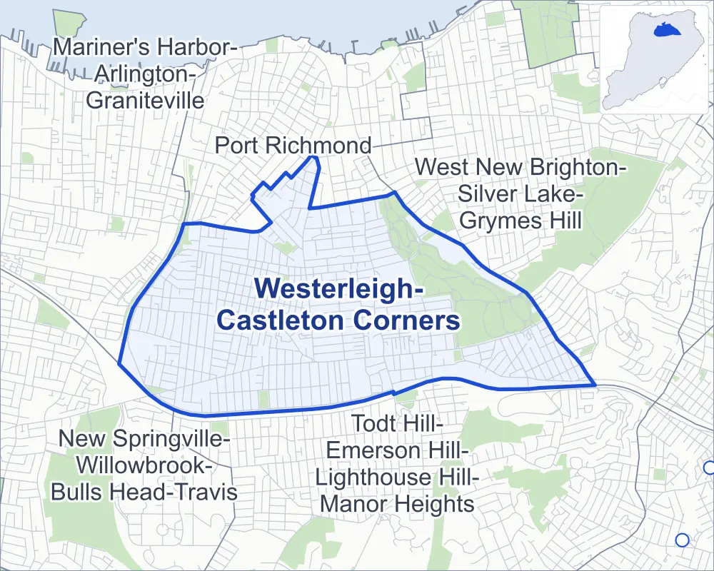
- Westerleigh-Castleton Corners
- A neighboring area
- Park
- Another station
Neighborhood areas and streets: NYC Department of City Planning. Parks: NYC Parks. Stations: MTA.
Neighboring areas
Getting around
Buses on 24 routes stop in or at the edge of Westerleigh-Castleton Corners.
- 15 local bus routes
- 9 express bus routes
Local bus routes
- S44
- S48
- S53
- S54
- S57
- S59
- S61
- S62
- S66
- S78
- S91
- S92
- S93
- S94
- S98
Express bus routes
- SIM3
- SIM3C
- SIM30
- SIM31
- SIM32
- SIM33
- SIM33C
- SIM34
- SIM35
Safety record
Between 2021 and 2025, its corners averaged fewer police-reported crashes than the average Staten Island corner.
- 1,248 police-reported crashes at its corners
- 2.1 a corner, on average
- 2.2 the average Staten Island corner
- 277 corners with a clean record
Signal or safety changes on City record, at 49 of its corners
- Accessible pedestrian signals
- 48
- Leading pedestrian intervals
- 13
- Turn calming
- 7
Camera tickets
In 2025 its corners had more school-zone speed camera tickets than red-light or bus-lane tickets.
- 1,301 red-light camera tickets at three corners
- 39,607 school-zone speed camera tickets at 18 corners
- 0 bus-lane camera tickets
- Most red-light tickets
- Clove Road & Narrows Road North, 1,008
- Most speed tickets
- Willow Road East & Home Place, 18,488
People and homes
The 2020 Census counted 31,458 residents in Westerleigh-Castleton Corners, about 11,400 per square mile.
- 12,046 homes, 2020 Census
- 257 homes added since April 2010, net, by City Planning's count
Half of its 8,635 residential lots hold buildings from 1955 or earlier, and 31% of them date from before 1940, by the City's tax lot records.
Parks and landmarks
- Parkland
- 193.4 acres of Clove Lakes Park, as NYC Parks maps it within Westerleigh-Castleton Corners
- Designated landmarks
- The Headquarters Troop, 51st Cavalry Brigade Armory; and the Motor Vehicle Storage Building and Service Center
Streets and trees
- Trees
- 8,364 in NYC Parks' records, most often pin oak, London planetree and red maple
- Street with the most corners
- Victory Boulevard, with 54 of the area's 584
- Height above sea level
- From 14 feet at Post Avenue & Mitchel Lane to 261 feet at Royal Oak Road & Knox Place
- Honorary street names
- 45 at its corners, enacted by local law
Schools and libraries
The City lists ten schools and one library in Westerleigh-Castleton Corners.
- Public schools
- 4
- Charter and private schools
- 6
- Library
- Todt Hill-Westerleigh Library
Public art
The City's public art inventory lists two works in Westerleigh-Castleton Corners: Blazed and Willowbrook Roads Tablet (1921) and A Bird Named Goldilocks (1995).
- 2 works of public art
Public safety
How complaints are countedIn 2025 the NYPD recorded 159 major felonies at places in Westerleigh-Castleton Corners.
Recorded by the NYPD at places in Westerleigh-Castleton Corners
- 135 major felonies in 2024
- 731 other felonies, misdemeanors and violations in 2025
In 2025, on the streets along the edge of Westerleigh-Castleton Corners, the NYPD recorded another 39 major felonies. Counting the streets along its edge, in 2025 the NYPD recorded 6.3 major felonies for every thousand residents the 2020 Census counted in Westerleigh-Castleton Corners.
- Police precincts
- 121st, 120th (most of the area)
From January to June 2026 the NYPD recorded 78 major felonies at places in Westerleigh-Castleton Corners, against 73 in the same months of 2025.
Sources: the NYPD's Complaint Data Historic, updated April 28, 2026, and Complaint Data Current (Year To Date), updated July 27, 2026, on NYC Open Data. Figures to June 30, 2026.
Street corners
- Auburn Avenue & Cambridge Avenue
- Auburn Avenue & Hawthorne Avenue
- Auburn Avenue & Stewart Avenue
- Auburn Avenue & Woodbine Avenue
- Avon Lane & Willard Place
- Aymar Avenue & Cypress Avenue
- Beechwood Place & Dongan Avenue
- Beechwood Place & Sturges Street
- Bellhaven Place & Decatur Avenue
- Benedict Avenue & Brookside Avenue
- Benedict Avenue & Elias Place
- Benedict Avenue & Mundy Avenue
- Bidwell Avenue & Columbus Place
- Bidwell Avenue & Garrison Avenue
- Bidwell Avenue & North Avenue
- Bidwell Avenue & Springfield Avenue
- Bradley Avenue & Purdy Avenue
- Bradley Avenue & Watchogue Road
- Brookside Avenue & Alpine Court
- Bryson Avenue & Auburn Avenue
- Bryson Avenue & Lathrop Avenue
- Bryson Avenue & Leonard Avenue
- Bryson Avenue & Waters Avenue
- Burnside Avenue & Shaw Place
- Byrne Avenue & Marble Street
- Cambridge Avenue & Nina Avenue
- Carmel Avenue & Bass Street
- Carmel Avenue & Caro Street
- Caswell Avenue & Bryson Avenue
- Caswell Avenue & Cambridge Avenue
- Caswell Avenue & Canterbury Avenue
- Caswell Avenue & Collfield Avenue
- Caswell Avenue & Crystal Avenue
- Caswell Avenue & Harvey Avenue
- Caswell Avenue & Hawthorne Avenue
- Caswell Avenue & Livermore Avenue
- Caswell Avenue & O'Connor Avenue
- Caswell Avenue & Stewart Avenue
- Caswell Avenue & Tremont Avenue
- Caswell Avenue & Willowbrook Road
- Caswell Avenue & Woodbine Avenue
- Caswell Avenue & Woolley Avenue
- Catherine Street & Borg Court
- Catherine Street & Lexington Avenue
- Cattaraugus Street & Dobbs Place
- Cattaraugus Street & Otsego Avenue
- Cayuga Avenue & Schoharie Street
- Cayuga Avenue & Tioga Street
- Clinton B Fisk Avenue & The Boulevard
- Clinton B Fisk Avenue & Woodbridge Place
- Clove Road & Allen Court
- Clove Road & Broadway
- Clove Road & Clove Lake Place
- Clove Road & Dudley Avenue
- Clove Road & Fairway Lane
- Clove Road & Ludwig Street
- Clove Road & Narrows Road North
- Clove Road & Oswego Street
- Clove Road & Purcell Street
- Clove Road & Sunnyside Terrace
- Clove Road & Van Cortlandt Avenue
- College Avenue & Alabama Place
- College Avenue & Bidwell Avenue
- College Avenue & Brookside Avenue
- College Avenue & Bryson Avenue
- College Avenue & Carolina Place
- College Avenue & Clinton B Fisk Avenue
- College Avenue & Collfield Avenue
- College Avenue & Colorado Street
- College Avenue & Crystal Avenue
- College Avenue & Delaware Place
- College Avenue & Dickie Avenue
- College Avenue & Livermore Avenue
- College Avenue & Lockwood Place
- College Avenue & Marianne Street
- College Avenue & Maryland Place
- College Avenue & Neal Dow Avenue
- College Avenue & New York Place
- College Avenue & Ohio Place
- College Avenue & Wardwell Avenue
- College Avenue & Willard Avenue
- Collfield Avenue & Auburn Avenue
- Collfield Avenue & Bellhaven Place
- Collfield Avenue & Lathrop Avenue
- Collfield Avenue & Leonard Avenue
- Collfield Avenue & Waters Avenue
- Constant Avenue & Miller Street
- Constant Avenue & Ohio Place
- Constant Avenue & Virginia Place
- Cortlandt Street & Catherine Street
- Cortlandt Street & Haughwout Avenue
- Cortlandt Street & Sharrett Place
- Crowell Avenue & Raymond Avenue
- Crystal Avenue & Auburn Avenue
- Crystal Avenue & Delmore Street
- Crystal Avenue & Dora Street
- Crystal Avenue & Fillat Street
- Crystal Avenue & Galloway Avenue
- Crystal Avenue & Garrison Avenue
- Crystal Avenue & Gurdon Street
- Crystal Avenue & Lathrop Avenue
- Crystal Avenue & Leonard Avenue
- Crystal Avenue & Riegelmann Street
- Crystal Avenue & Wade Street
- Crystal Avenue & Waters Avenue
- Cypress Avenue & Bristol Avenue
- Decker Avenue & Barrett Avenue at Cornell Street
- Decker Avenue & Beekman Street
- Deems Avenue & Markham Place
- Deems Avenue & The Boulevard
- Delmore Street & Earley Avenue
- Derby Court & Bache Street
- Derby Court & Kramer Place
- Devens Street & Lyon Place
- Devens Street & Tuttle Street
- Dickie Avenue & Garrison Avenue
- Dickie Avenue & North Avenue
- Dongan Avenue & Hodges Place
- Drake Avenue & Smith Avenue
- Dubois Avenue & Egbert Avenue
- Egbert Avenue & Greenleaf Avenue
- Egbert Avenue & Karen Court
- Egbert Avenue & Llewellyn Place
- Egbert Avenue & Mundy Avenue
- Egbert Avenue & Raymond Place
- Eldridge Avenue & Clark Place
- Eldridge Avenue & St Anthony Place
- Elvin Street & Garden Street
- Fairview Avenue & Drake Avenue
- Fairview Avenue & Ellsworth Place
- Fairview Avenue & Governor Road
- Fairview Avenue & Knox Place
- Fairview Avenue & Sanford Place
- Fairview Avenue & Utter Avenue
- Forest Avenue & Arnprior Street
- Forest Avenue & Barrett Avenue
- Forest Avenue & Burnside Avenue
- Forest Avenue & Clove Road
- Forest Avenue & Crystal Avenue
- Forest Avenue & Dubois Avenue
- Forest Avenue & Eldridge Avenue
- Forest Avenue & Hamlin Place
- Forest Avenue & Jewett Avenue
- Forest Avenue & Llewellyn Place
- Forest Avenue & Mundy Avenue
- Forest Avenue & Ordell Avenue
- Forest Avenue & Veltman Avenue
- Forest Avenue & Villa Avenue
- Forest Avenue & Willowbrook Road
- Frederick Street & Avon Lane
- Galloway Avenue & Marianne Street
- Gansevoort Boulevard & Purdy Avenue
- Garrison Avenue & Glascoe Avenue
- Glascoe Avenue & Columbus Place
- Governor Road & Beechwood Place
- Gower Street & Alexandra Place
- Gower Street & Lester Street
- Gower Street & Penn Street
- Greenleaf Avenue & Arthur Court
- Hamlin Place & Haughwout Avenue
- Hamlin Place & Newkirk Avenue
- Haughwout Avenue & Derby Court
- Haughwout Avenue & Dryden Court
- Hawthorne Avenue & Denton Place
- Hawthorne Avenue & Holgate Street
- Hawthorne Avenue & Montauk Place
- Hawthorne Avenue & Wyona Avenue
- Home Place & Echo Place
- Home Place & Levit Avenue
- Home Place & Lyon Place
- Houston Street & Houston Lane
- Ingram Avenue & Marble Street
- Jewett Avenue & Burnside Avenue
- Jewett Avenue & Chandler Avenue
- Jewett Avenue & Coale Avenue
- Jewett Avenue & College Avenue
- Jewett Avenue & Constant Avenue
- Jewett Avenue & Crowell Avenue
- Jewett Avenue & Egbert Avenue
- Jewett Avenue & Goodwin Avenue
- Jewett Avenue & Keiber Court
- Jewett Avenue & Kemball Avenue
- Jewett Avenue & Kingsley Avenue
- Jewett Avenue & Leonard Avenue
- Jewett Avenue & Maine Avenue
- Jewett Avenue & Margaretta Court
- Jewett Avenue & Ravenhurst Avenue
- Jewett Avenue & Sawyer Avenue
- Jewett Avenue & The Boulevard
- Jewett Avenue & Veltman Avenue
- Jewett Avenue & Vogel Loop
- Jewett Avenue & Waters Avenue
- Jewett Avenue & Zachary Court
- Karen Court & Jillian Court
- Keiber Court & Miller Street
- Kell Avenue & Marble Street
- Kingsley Avenue & Brookside Avenue
- Kingsley Avenue & Colorado Street
- Kingsley Avenue & New York Place
- Kramer Place & Mitchel Lane
- Labau Avenue & Northern Boulevard
- Labau Avenue & Oswego Street
- Lathrop Avenue & Bidwell Avenue
- Lathrop Avenue & Clinton B Fisk Avenue
- Lathrop Avenue & Demorest Avenue
- Lathrop Avenue & Dickie Avenue
- Lathrop Avenue & Glascoe Avenue
- Lathrop Avenue & Muller Avenue
- Lathrop Avenue & St John Avenue
- Lathrop Avenue & Willard Avenue
- Leonard Avenue & Bidwell Avenue
- Leonard Avenue & Clinton B Fisk Avenue
- Leonard Avenue & Deems Avenue
- Leonard Avenue & Demorest Avenue
- Leonard Avenue & Dickie Avenue
- Leonard Avenue & Glascoe Avenue
- Leonard Avenue & Muller Avenue
- Leonard Avenue & Neal Dow Avenue
- Leonard Avenue & St John Avenue
- Leonard Avenue & Wardwell Avenue
- Leonard Avenue & Willard Avenue
- Lester Street & Josephine Street
- Levit Avenue & Devens Street
- Levit Avenue & Eagle Road
- Levit Avenue & Jaffe Street
- Levit Avenue & Vedder Avenue
- Little Clove Road & Albert Street
- Little Clove Road & Aymar Avenue
- Little Clove Road & Bristol Avenue
- Little Clove Road & Cayuga Avenue
- Little Clove Road & Labau Avenue
- Little Clove Road & Logan Avenue
- Little Clove Road & Northern Boulevard
- Little Clove Road & Oneida Avenue
- Little Clove Road & Ontario Avenue
- Little Clove Road & Otsego Avenue
- Little Clove Road & Renwick Avenue
- Little Clove Road & Seneca Avenue
- Little Clove Road & Walters Avenue
- Little Clove Road & Windsor Road
- Livermore Avenue & Delmore Street
- Livermore Avenue & Garrison Avenue
- Livermore Avenue & Lathrop Avenue
- Livermore Avenue & Leonard Avenue
- Livermore Avenue & North Avenue
- Livermore Avenue & Ruth Street
- Livermore Avenue & Waters Avenue
- Livermore Avenue & Wilbur Place
- Maine Avenue & Alabama Place
- Maine Avenue & Bidwell Avenue
- Maine Avenue & Clinton B Fisk Avenue
- Maine Avenue & Crystal Avenue
- Maine Avenue & Dickie Avenue
- Maine Avenue & Glascoe Avenue
- Maine Avenue & Livermore Avenue
- Maine Avenue & Miller Street
- Maine Avenue & Muller Avenue
- Maine Avenue & Neal Dow Avenue
- Maine Avenue & New York Place
- Maine Avenue & Ohio Place
- Maine Avenue & South Greenleaf Avenue
- Maine Avenue & Virginia Place
- Maine Avenue & Wardwell Avenue
- Maine Avenue & Westcott Boulevard
- Maine Avenue & Willard Avenue
- Manor Road & Alpine Court
- Manor Road & Benedict Avenue
- Manor Road & College Avenue
- Manor Road & Constant Avenue
- Manor Road & Crowell Avenue
- Manor Road & Curtis Avenue
- Manor Road & Dongan Avenue
- Manor Road & Dore Court
- Manor Road & Drake Avenue
- Manor Road & Egbert Avenue
- Manor Road & Garden Street
- Manor Road & Governor Road
- Manor Road & Joan Place
- Manor Road & Josephine Street
- Manor Road & Keiber Court
- Manor Road & Kingsley Avenue
- Manor Road & Maine Avenue
- Manor Road & Merriman Avenue
- Manor Road & North Gannon Avenue
- Manor Road & Potter Avenue
- Manor Road & Ravenhurst Avenue
- Manor Road & Reon Avenue
- Manor Road & Rice Avenue
- Manor Road & Staten Island Armory Driveway (north)
- Manor Road & Staten Island Armory Driveway (south)
- Manor Road & Utter Avenue
- Manor Road & Windsor Road
- Marble Street & Cheves Avenue
- Marble Street & Harvey Avenue
- Marble Street & O'Connor Avenue
- Marble Street & Seward Place
- Markham Place & Dakota Place
- Martling Avenue & Brooks Pond Place
- Martling Avenue & Brookside Avenue
- Marx Street & Albert Street
- Mountain View Avenue & Purdy Avenue
- Muller Avenue & Columbus Place
- Muller Avenue & Garrison Avenue
- Muller Avenue & Wade Street
- Mundy Avenue & Jillian Court
- Narrows Road North & Little Clove Road
- Neal Dow Avenue & Garrison Avenue
- Neal Dow Avenue & Lathrop Avenue
- Neal Dow Avenue & North Avenue
- Neal Dow Avenue & Seward Place
- Neal Dow Avenue & Springfield Avenue
- North Avenue & Lockwood Place
- North Gannon Avenue & Ardmore Avenue
- North Gannon Avenue & Bradley Avenue
- North Gannon Avenue & Byrne Avenue
- North Gannon Avenue & Clermont Place
- North Gannon Avenue & Collfield Avenue
- North Gannon Avenue & Crafton Avenue
- North Gannon Avenue & Elvin Street
- North Gannon Avenue & Gansevoort Boulevard
- North Gannon Avenue & Gower Street
- North Gannon Avenue & Ingram Avenue
- North Gannon Avenue & Kell Avenue
- North Gannon Avenue & Mann Avenue
- North Gannon Avenue & Martin Avenue
- North Gannon Avenue & Mountain View Avenue
- North Gannon Avenue & Perry Avenue
- North Gannon Avenue & Quinlan Avenue
- North Gannon Avenue & Reon Avenue
- North Gannon Avenue & Sheraden Avenue
- North Gannon Avenue & Staten Island Expressway
- North Gannon Avenue & Warwick Avenue
- North Gannon Avenue & Wheeler Avenue
- North Gannon Avenue & Woodward Avenue
- North Gannon Avenue & Woolley Avenue
- Northern Boulevard & Cypress Avenue
- Ontario Avenue & Oswego Street
- Ontario Avenue & Schoharie Street
- Ontario Avenue & Tioga Street
- Oswego Street & Cayuga Avenue
- Oswego Street & Logan Avenue
- Oswego Street & Oneida Avenue
- Palmer Avenue & Cortlandt Street
- Post Avenue & Mitchel Lane
- Potter Avenue & Fairview Avenue
- Potter Avenue & Royal Oak Road
- Potter Avenue & Smith Avenue
- Purdy Avenue & Ardmore Avenue
- Purdy Avenue & Byrne Avenue
- Purdy Avenue & Carmel Avenue
- Purdy Avenue & Clermont Place
- Purdy Avenue & Crafton Avenue
- Purdy Avenue & Ingram Avenue
- Purdy Avenue & Kell Avenue
- Purdy Avenue & Mann Avenue
- Purdy Avenue & Martin Avenue
- Purdy Avenue & Perry Avenue
- Purdy Avenue & Quinlan Avenue
- Purdy Avenue & Sheraden Avenue
- Purdy Avenue & Warwick Avenue
- Purdy Avenue & Wheeler Avenue
- Purdy Avenue & Woodward Avenue
- Ravenhurst Avenue & Elias Place
- Ravenhurst Avenue & Karen Court
- Ravenhurst Avenue & Mundy Avenue
- Renwick Avenue & Cattaraugus Street
- Renwick Avenue & Northern Boulevard
- Renwick Avenue & Oswego Street
- Reon Avenue & Henning Street
- Reon Avenue & Sommers Lane
- Reon Avenue & Staten Island Expressway
- Rice Avenue & Fairview Avenue
- Rice Avenue & Royal Oak Road
- Rice Avenue & Smith Avenue
- Riegelmann Street & Arnprior Street
- Riegelmann Street & Pontiac Street
- Royal Oak Road & Knox Place
- Royal Oak Road & Lakeland Road
- Royal Oak Road & Sanford Place
- Sanford Place & Brenton Place
- Seneca Avenue & Genesee Street
- Seneca Avenue & Niagara Street
- Seneca Avenue & Oswego Street
- Seneca Avenue & Schoharie Street
- Seneca Avenue & Tioga Street
- Slosson Avenue & Drake Avenue
- Slosson Avenue & Ellsworth Place
- Slosson Avenue & Knox Place
- Slosson Avenue & Lakeland Road
- Slosson Avenue & Martling Avenue
- Slosson Avenue & Potter Avenue
- Slosson Avenue & Reon Avenue
- Slosson Avenue & Rice Avenue
- Slosson Avenue & Sanford Place
- Slosson Avenue & Utter Avenue
- Slosson Avenue & Windsor Road
- South Greenleaf Avenue & Benedict Avenue
- South Greenleaf Avenue & Chandler Avenue
- South Greenleaf Avenue & Coale Avenue
- South Greenleaf Avenue & Constant Avenue
- South Greenleaf Avenue & Crowell Avenue
- South Greenleaf Avenue & Goodell Avenue
- South Greenleaf Avenue & Goodwin Avenue
- South Greenleaf Avenue & Joan Place
- South Greenleaf Avenue & Keiber Court
- South Greenleaf Avenue & Margaretta Court
- South Greenleaf Avenue & Merriman Avenue
- South Greenleaf Avenue & Ravenhurst Avenue
- South Greenleaf Avenue & Sawyer Avenue
- Staten Island Expressway & Clove Road
- Staten Island Expressway & Renwick Avenue
- Staten Island Expressway & Slosson Avenue
- Tioga Street & Oneida Avenue
- Todt Hill Road & Reon Avenue
- Todt Hill Road & Windsor Road
- Utter Avenue & Smith Avenue
- Veltman Avenue & Hamlin Place
- Veltman Avenue & Ordell Avenue
- Victory Boulevard & Albert Street
- Victory Boulevard & Ardmore Avenue
- Victory Boulevard & Auburn Avenue
- Victory Boulevard & Beechwood Place
- Victory Boulevard & Bradley Avenue
- Victory Boulevard & Brenton Place
- Victory Boulevard & Bryson Avenue
- Victory Boulevard & Byrne Avenue
- Victory Boulevard & Carmel Avenue
- Victory Boulevard & Clermont Place
- Victory Boulevard & Clove Road
- Victory Boulevard & Collfield Avenue
- Victory Boulevard & Crystal Avenue
- Victory Boulevard & Cypress Avenue
- Victory Boulevard & Fairview Avenue
- Victory Boulevard & Gansevoort Boulevard
- Victory Boulevard & Harvey Avenue
- Victory Boulevard & Hodges Place
- Victory Boulevard & Ingram Avenue
- Victory Boulevard & Jewett Avenue
- Victory Boulevard & Kell Avenue
- Victory Boulevard & Labau Avenue
- Victory Boulevard & Lester Street
- Victory Boulevard & Little Clove Road
- Victory Boulevard & Livermore Avenue
- Victory Boulevard & Logan Avenue
- Victory Boulevard & Mann Avenue
- Victory Boulevard & Manor Road
- Victory Boulevard & Marx Street
- Victory Boulevard & Moonlight Court
- Victory Boulevard & Mountain View Avenue
- Victory Boulevard & Neptune Place
- Victory Boulevard & O'Connor Avenue
- Victory Boulevard & Ontario Avenue
- Victory Boulevard & Perry Avenue
- Victory Boulevard & Quinlan Avenue
- Victory Boulevard & Raymond Avenue
- Victory Boulevard & Renwick Avenue
- Victory Boulevard & Royal Oak Road
- Victory Boulevard & Seneca Avenue
- Victory Boulevard & Sheraden Avenue
- Victory Boulevard & Slosson Avenue
- Victory Boulevard & Sommers Lane
- Victory Boulevard & South Greenleaf Avenue
- Victory Boulevard & St Pauls Seminary Driveway
- Victory Boulevard & Stewart Avenue
- Victory Boulevard & Todt Hill Road
- Victory Boulevard & Watchogue Road
- Victory Boulevard & Westcott Boulevard
- Victory Boulevard & Wheeler Avenue
- Victory Boulevard & Willowbrook Road
- Victory Boulevard & Winthrop Place
- Victory Boulevard & Woolley Avenue
- Victory Boulevard & Wyona Avenue
- Vogel Loop & Vogel Lane
- Walters Avenue & Albert Street
- Walters Avenue & Marx Street
- Wardwell Avenue & Markham Place
- Wardwell Avenue & The Boulevard
- Watchogue Road & Avon Lane
- Watchogue Road & Bidwell Avenue
- Watchogue Road & Bryson Avenue
- Watchogue Road & Cambridge Avenue
- Watchogue Road & Canterbury Avenue
- Watchogue Road & Cheves Avenue
- Watchogue Road & Clinton B Fisk Avenue
- Watchogue Road & Collfield Avenue
- Watchogue Road & Crystal Avenue
- Watchogue Road & Demorest Avenue
- Watchogue Road & Dickie Avenue
- Watchogue Road & Echo Place
- Watchogue Road & Frederick Street
- Watchogue Road & Glascoe Avenue
- Watchogue Road & Hawthorne Avenue
- Watchogue Road & Levit Avenue
- Watchogue Road & Livermore Avenue
- Watchogue Road & Lyon Place
- Watchogue Road & Marble Street
- Watchogue Road & Muller Avenue
- Watchogue Road & Neal Dow Avenue
- Watchogue Road & Smith Court
- Watchogue Road & St John Avenue
- Watchogue Road & Treetz Place
- Watchogue Road & Tremont Avenue
- Watchogue Road & Willard Avenue
- Watchogue Road & Willard Place
- Watchogue Road & Woodbine Avenue
- Waters Avenue & Bidwell Avenue
- Waters Avenue & Clinton B Fisk Avenue
- Waters Avenue & Dakota Place
- Waters Avenue & Deems Avenue
- Waters Avenue & Demorest Avenue
- Waters Avenue & Dickie Avenue
- Waters Avenue & Glascoe Avenue
- Waters Avenue & Muller Avenue
- Waters Avenue & Neal Dow Avenue
- Waters Avenue & St John Avenue
- Waters Avenue & Wardwell Avenue
- Waters Avenue & Willard Avenue
- Westcott Boulevard & Chandler Avenue
- Westcott Boulevard & Coale Avenue
- Westcott Boulevard & Constant Avenue
- Westcott Boulevard & Crowell Avenue
- Westcott Boulevard & Elmira Avenue
- Westcott Boulevard & Goodwin Avenue
- Westcott Boulevard & Keiber Court
- Westcott Boulevard & Kemball Avenue
- Westcott Boulevard & Margaretta Court
- Westcott Boulevard & Sawyer Avenue
- Willard Avenue & Springfield Avenue
- Willard Avenue & Woodbridge Place
- Willow Road East & Cambridge Avenue
- Willow Road East & Caswell Avenue
- Willow Road East & Devens Street
- Willow Road East & Dr M L King Jr Expressway
- Willow Road East & Eagle Road
- Willow Road East & Home Place
- Willow Road East & Houston Street
- Willow Road East & Nina Avenue
- Willow Road East & Vedder Avenue
- Willow Road East & Watchogue Road
- Willow Road East & Wyona Avenue
- Willowbrook Road & Auburn Avenue
- Willowbrook Road & College Avenue
- Willowbrook Road & College Court
- Willowbrook Road & Denton Place
- Willowbrook Road & Devens Street
- Willowbrook Road & Francine Lane
- Willowbrook Road & Gloria Court
- Willowbrook Road & Holgate Street
- Willowbrook Road & Home Place
- Willowbrook Road & Jaffe Street
- Willowbrook Road & Lathrop Avenue
- Willowbrook Road & Leonard Avenue
- Willowbrook Road & Montauk Place
- Willowbrook Road & Neptune Place
- Willowbrook Road & North Gannon Avenue
- Willowbrook Road & Riegelmann Street
- Willowbrook Road & Vedder Avenue
- Willowbrook Road & Watchogue Road
- Willowbrook Road & Watchogue Road at Stewart Avenue
- Willowbrook Road & Waters Avenue
- Willowbrook Road & Willowbrook Court
- Willowbrook Road & Wyona Avenue
- Windsor Road & Henning Street
- Windsor Road & Sommers Lane
- Windsor Road & Windsor Court
- Windsor Road & Winthrop Place
- Winthrop Place & Dongan Avenue
- Woodbine Avenue & Thurston Street
- Woodbine Avenue & Wyona Avenue
- Woolley Avenue & College Avenue
- Woolley Avenue & Columbus Place
- Woolley Avenue & Delmore Street
- Woolley Avenue & Dora Street
- Woolley Avenue & Fillat Street
- Woolley Avenue & Garrison Avenue
- Woolley Avenue & Gurdon Street
- Woolley Avenue & Lathrop Avenue
- Woolley Avenue & Leonard Avenue
- Woolley Avenue & Maine Avenue
- Woolley Avenue & Purdy Avenue
- Woolley Avenue & Ruth Street
- Woolley Avenue & Watchogue Road
- Woolley Avenue & Waters Avenue
- Woolley Avenue & Wilbur Place
How the figures above are measured: Methodology.