Port Richmond
Neighborhood · Staten Island
Port Richmond fronts the Kill Van Kull on Staten Island's North Shore and also takes in neighboring Elm Park, named for the elm trees on a doctor's estate.
- 1.30 square miles
- 22,609 residents, 2020 Census
- 260 street corners
- 18 bus routes
The community grew around a ferry to Bergen Point, now in Bayonne, New Jersey; by 1757 the crossing was a key link on the route between New York and Philadelphia. The Reformed Church on Staten Island, whose congregation dates to 1664, finished its Greek Revival church in 1844 beside the oldest non-private cemetery on the island. When the Staten Island Railway added a stop in the 1880s, the village was already one of the island's main shopping areas.
Sources: Reformed Church on Staten Island, Sunday School Building, and Cemetery Designation Report (LP-2384, March 23, 2010) (NYC Landmarks Preservation Commission); Port Richmond, Staten Island (Wikipedia); Elm Park, Staten Island (Wikipedia).
Port Richmond borders three areas, and Port Richmond Avenue holds more of its corners than any other street, 35 of 260.
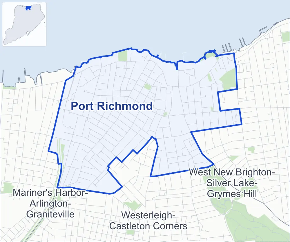
- Port Richmond
- A neighboring area
- Park
Neighborhood areas and streets: NYC Department of City Planning. Parks: NYC Parks. Stations: MTA.
Neighboring areas
Getting around
Buses on 18 routes stop in or at the edge of Port Richmond.
- 14 local bus routes
- 4 express bus routes
Local bus routes
- S40
- S44
- S46
- S48
- S53
- S54
- S57
- S59
- S66
- S89
- S90
- S94
- S96
- S98
Express bus routes
- SIM3
- SIM3C
- SIM30
- SIM35
Safety record
Between 2021 and 2025, its corners averaged more police-reported crashes than the average Staten Island corner.
- 884 police-reported crashes at its corners
- 3.4 a corner, on average
- 2.2 the average Staten Island corner
- 51 corners with a clean record
Signal or safety changes on City record, at 32 of its corners
- Accessible pedestrian signals
- 30
- Leading pedestrian intervals
- 20
- Turn calming
- 3
- Safety Improvement Projects
- 1
Camera tickets
In 2025 its corners had more school-zone speed camera tickets than red-light or bus-lane tickets.
- 0 red-light camera tickets
- 15,349 school-zone speed camera tickets at 16 corners
- 0 bus-lane camera tickets
- Most speed tickets
- Trantor Place & Dixon Avenue, 4,252
People and homes
The 2020 Census counted 22,609 residents in Port Richmond, about 17,400 per square mile.
- 7,391 homes, 2020 Census
- 320 homes added since April 2010, net, by City Planning's count
Half of its 4,060 residential lots hold buildings from 1925 or earlier, and 69% of them date from before 1940, by the City's tax lot records.
Parks and landmarks
- Parkland
- 21.4 acres of NYC Parks property
- The largest pieces
- CPL. Thompson Park (10.8 acres), Faber Pool and Park (4.3 acres) and Heritage Park (3.9 acres)
- Designated landmarks
- The Northfield Township District School 6; the New York Public Library's Port Richmond Branch; and the Reformed Church on Staten Island, Sunday School Bldg, & Cemetery
Streets and trees
- Trees
- 2,687 in NYC Parks' records, most often Japanese flowering cherry, Callery pear and red maple
- Street with the most corners
- Port Richmond Avenue, with 35 of the area's 260
- Height above sea level
- From 6 feet at Richmond Terrace & Nicholas Avenue to 68 feet at Forest Avenue & Raymond Place
- Honorary street names
- 27 at its corners, enacted by local law
Schools and libraries
The City lists ten schools and one library in Port Richmond.
- Public schools
- 6
- Charter and private schools
- 4
- Library
- Port Richmond Library
Public art
The City's public art inventory lists three works in Port Richmond: Eugene G. Putnam (1915), Egbert Memorial (1958) and Sundial (1994).
- 3 works of public art
Public safety
How complaints are countedIn 2025 the NYPD recorded 204 major felonies at places in Port Richmond.
Recorded by the NYPD at places in Port Richmond
- 252 major felonies in 2024 48 fewer in 2025
- 1,245 other felonies, misdemeanors and violations in 2025
In 2025, on the streets along the edge of Port Richmond, the NYPD recorded another 89 major felonies. Counting the streets along its edge, in 2025 the NYPD recorded 13.0 major felonies for every thousand residents the 2020 Census counted in Port Richmond.
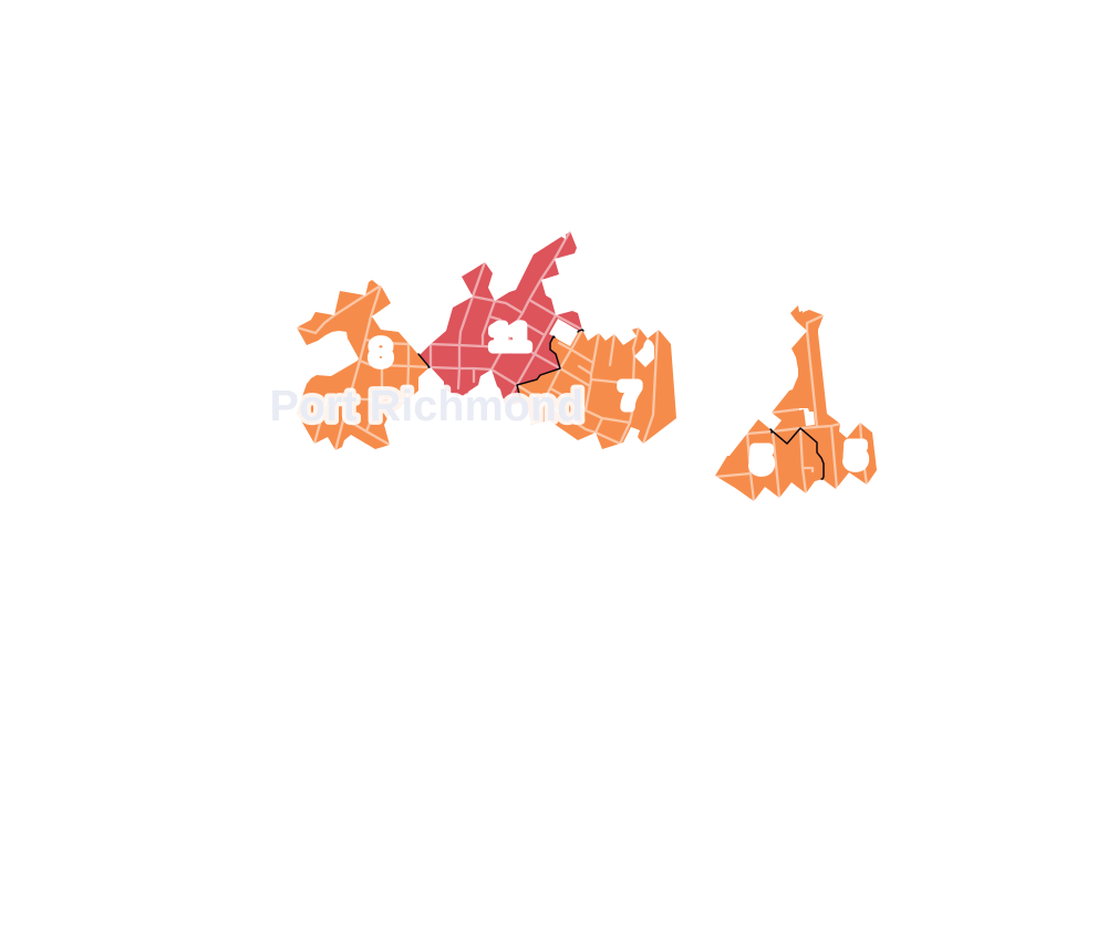
- 5 to 9
- 10 to 19
- 20 to 49
- 50 to 99
- 100 or more
- Not shaded: fewer than 5, held back under the rules in How complaints are counted, parks and public-housing grounds, and land in no patch
- Police precincts
- 121st (most of the area), 120th
From January to June 2026 the NYPD recorded 89 major felonies at places in Port Richmond, against 85 in the same months of 2025.
Sources: the NYPD's Complaint Data Historic, updated April 28, 2026, and Complaint Data Current (Year To Date), updated July 27, 2026, on NYC Open Data. Figures to June 30, 2026.
Street corners
- Alaska Street & Wayne Street
- Alaska Street & West Brighton I Houses Driveway
- Alaska Street & Woodruff Lane
- Albion Place & Washington Place
- Anderson Avenue & Simonson Place
- Anderson Avenue & Washington Place
- Barker Street & Trinity Place
- Bayonne Bridge & Innis Street
- Bayonne Bridge & Newark Avenue
- Beekman Street & La Grange Place
- Beekman Street & Riley Place
- Bennett Street & Avenue B
- Bennett Street & Cottage Place
- Bodine Street & De Groot Place
- Bond Street & Cottage Place
- Broadway & Britton Street
- Broadway & Markham Lane
- Broadway & Skinner Lane
- Broadway & South Street
- Burden Avenue & Laforge Place
- Cary Avenue & Roe Street
- Cary Avenue & Taylor Street
- Castleton Avenue & Alaska Street
- Castleton Avenue & Barker Street
- Castleton Avenue & Bodine Street
- Castleton Avenue & Caroline Street
- Castleton Avenue & Dongan Street
- Castleton Avenue & Elizabeth Street
- Castleton Avenue & Faber Street
- Castleton Avenue & Grove Place
- Castleton Avenue & Heberton Avenue
- Castleton Avenue & Jewett Avenue
- Castleton Avenue & Nicholas Avenue
- Castleton Avenue & Park Avenue
- Castleton Avenue & Port Richmond Avenue
- Castleton Avenue & Rector Street
- Castleton Avenue & Roe Street
- Castleton Avenue & Sharpe Avenue
- Castleton Avenue & Simonson Place
- Castleton Avenue & State Street
- Castleton Avenue & Taylor Street
- Castleton Avenue & Treadwell Avenue
- Catherine Street & La Grange Place
- Chappell Street & Wayne Street
- Charles Avenue & Crittenden Place
- Clove Road & Castleton Avenue
- Clove Road & De Groot Place
- Clove Road & Delafield Avenue
- Clove Road & Disosway Place
- Clove Road & Guinevere Lane
- Clove Road & Post Avenue
- Clove Road & White Place
- Cortlandt Street & Kramer Place
- Cottage Place & Vreeland Street
- Decker Avenue & Barrett Avenue
- Decker Avenue & Catherine Street
- Decker Avenue & Cornell Street
- Decker Avenue & Hagaman Place
- Decker Avenue & Montell Street
- Decker Avenue & Orange Avenue
- Decker Avenue & Palmer Avenue
- Decker Avenue & Smith Place
- Delafield Avenue & Dubois Avenue
- Delafield Avenue & Greenleaf Avenue
- Delafield Avenue & Raymond Place
- Dixon Avenue & Van Riper Street
- Dixon Avenue & Villa Avenue
- Dongan Street & De Groot Place
- Dongan Street & White Place
- Dr M L King Jr Expressway & Walker Street
- Dubois Avenue & Floyd Street
- Dubois Avenue & Hurst Street
- Dubois Avenue & Marion Street
- Eaton Place & John Street Pedestrian Overpass
- Faber Street & Grove Avenue
- Faber Street & Larkin Street
- Ferry Street & Gales Lane
- Floyd Street & Brooks Place
- Forest Avenue & Decker Avenue
- Forest Avenue & Greenleaf Avenue
- Forest Avenue & Livermore Avenue
- Forest Avenue & Manor Road
- Forest Avenue & Marianne Street
- Forest Avenue & Pontiac Street
- Forest Avenue & Raymond Place
- Greenleaf Avenue & Floyd Street
- Greenleaf Avenue & Marion Street
- Harrison Avenue & Faber Street
- Harrison Avenue & Maple Avenue
- Hatfield Place & Crittenden Place
- Heberton Avenue & Albion Place
- Heberton Avenue & Anderson Avenue
- Heberton Avenue & Ann Street
- Heberton Avenue & Bennett Street
- Heberton Avenue & Bond Street
- Heberton Avenue & Catherine Street
- Heberton Avenue & Clinton Place
- Heberton Avenue & Hatfield Place
- Heberton Avenue & Homestead Avenue
- Heberton Avenue & New Street
- Heberton Avenue & Palmer Avenue
- Heberton Avenue & Rainbow Avenue
- Heberton Avenue & Vreeland Street
- Henderson Avenue & Alaska Street
- Henderson Avenue & Chappell Street
- Hooker Place & Laforge Place
- Innis Street & Eaton Place
- Innis Street & St Josephs Avenue
- Jewett Avenue & Bache Street
- Jewett Avenue & Bennett Street
- Jewett Avenue & Bond Street
- Jewett Avenue & Catherine Court
- Jewett Avenue & Haughwout Avenue
- Jewett Avenue & Holbernt Court
- Jewett Avenue & Hurst Street
- Jewett Avenue & Kramer Place
- Jewett Avenue & New Street
- Jewett Avenue & Post Avenue
- Jewett Avenue & Wygant Place
- John Street & Eaton Place
- John Street & Innis Street
- John Street & Riverside Lane
- La Grange Place & Montell Street
- Laforge Avenue & Laforge Place
- Larkin Street & Kirkland Court
- Lexington Avenue & Sharrett Place
- Lyceum Court & Guinevere Lane
- Manor Road & Delafield Avenue
- Maple Avenue & Grove Avenue
- Morningstar Road & Dr MLK Expressway
- New Street & Cottage Place
- Nicholas Avenue & Blackford Avenue
- Nicholas Avenue & Charles Avenue
- Nicholas Avenue & Edgeview Lane
- Nicholas Avenue & Harrison Avenue
- Nicholas Avenue & Hatfield Place
- Nicholas Avenue & Hooker Place
- Nicholas Avenue & Innis Street
- Nicholas Avenue & Riverside Lane
- Nicholas Avenue & Slaight Street
- Openview Lane & Edgeview Lane
- Orange Avenue & Riley Place
- Orange Avenue & Seymour Avenue
- Palmer Avenue & Lexington Avenue
- Park Avenue & Anderson Avenue
- Park Avenue & Ann Street
- Park Avenue & Bennett Street
- Park Avenue & Church Street
- Park Avenue & New Street
- Park Avenue & Vreeland Street
- Port Richmond Avenue & Albion Place
- Port Richmond Avenue & Anderson Avenue
- Port Richmond Avenue & Ann Street
- Port Richmond Avenue & Beekman Street
- Port Richmond Avenue & Bennett Street
- Port Richmond Avenue & Blackford Avenue
- Port Richmond Avenue & Burden Avenue
- Port Richmond Avenue & Catherine Street
- Port Richmond Avenue & Charles Avenue
- Port Richmond Avenue & Church Street
- Port Richmond Avenue & Clinton Place
- Port Richmond Avenue & Dixon Avenue
- Port Richmond Avenue & Grove Avenue
- Port Richmond Avenue & Hagaman Place
- Port Richmond Avenue & Harrison Avenue
- Port Richmond Avenue & Hatfield Place
- Port Richmond Avenue & Homestead Avenue
- Port Richmond Avenue & Hooker Place
- Port Richmond Avenue & Laforge Avenue
- Port Richmond Avenue & Linda Court
- Port Richmond Avenue & New Street
- Port Richmond Avenue & Orange Avenue
- Port Richmond Avenue & Palmer Avenue
- Port Richmond Avenue & Post Avenue
- Port Richmond Avenue & Rainbow Avenue
- Port Richmond Avenue & Rumpler Court
- Port Richmond Avenue & Seymour Avenue
- Port Richmond Avenue & Smith Place
- Port Richmond Avenue & Trantor Place
- Port Richmond Avenue & Villa Avenue
- Port Richmond Avenue & Vreeland Street
- Port Richmond Avenue & Walker Street
- Post Avenue & Cortlandt Street
- Post Avenue & Decker Avenue
- Post Avenue & Driprock Street
- Post Avenue & Dubois Avenue
- Post Avenue & Greenleaf Avenue
- Post Avenue & Heberton Avenue
- Post Avenue & Sharpe Avenue
- Post Avenue & Simonson Place
- Raymond Place & Arcadia Place
- Raymond Place & Brooks Place
- Raymond Place & Disosway Place
- Raymond Place & Floyd Street
- Rector Street & Hurst Street
- Richmond Terrace & Alaska Street
- Richmond Terrace & Barrett Lane
- Richmond Terrace & Bayonne Bridge
- Richmond Terrace & Bodine Street
- Richmond Terrace & Broadway
- Richmond Terrace & Clove Road
- Richmond Terrace & Dongan Street
- Richmond Terrace & Faber Street
- Richmond Terrace & Ferry Street
- Richmond Terrace & Heberton Avenue
- Richmond Terrace & Jewett Avenue
- Richmond Terrace & John Street
- Richmond Terrace & Maple Avenue
- Richmond Terrace & Newark Avenue
- Richmond Terrace & Nicholas Avenue
- Richmond Terrace & North Street
- Richmond Terrace & Openview Lane
- Richmond Terrace & Park Avenue
- Richmond Terrace & Port Lane
- Richmond Terrace & Port Richmond Avenue
- Richmond Terrace & Port Richmond Water Plant Driveway
- Richmond Terrace & Rector Street
- Richmond Terrace & Sharpe Avenue
- Richmond Terrace & Taylor Street
- Richmond Terrace & Tompkins Court
- Richmond Terrace & Treadwell Avenue
- Richmond Terrace & Van Street
- Riverside Lane & Bayonne Court
- Riverside Lane & Openview Lane
- Roe Street & Rocco Court
- Sharpe Avenue & Charles Avenue
- Sharpe Avenue & Grove Avenue
- Sharpe Avenue & Harrison Avenue
- Sharpe Avenue & Hatfield Place
- Sharpe Avenue & Larkin Street
- Sharpe Avenue & Palmer Avenue
- Simonson Place & Bond Street
- Simonson Place & Catherine Court
- Tabb Place & Riley Place
- Taylor Street & De Groot Place
- Taylor Street & Paris Court
- Taylor Street & Taylor Court
- Taylor Street & Trinity Place
- Tompkins Court & Van Street
- Trantor Place & Bayonne Bridge
- Trantor Place & Bayonne Bridge Pedestrian and Bike Path
- Trantor Place & Dixon Avenue
- Trantor Place & Dr M L King Expressway
- Trantor Place & Dr Martin L King Expressway
- Trantor Place & Hooker Place
- Trantor Place & Innis Street
- Trantor Place & Tate Street
- Treadwell Avenue & Blackford Avenue
- Treadwell Avenue & Charles Avenue
- Treadwell Avenue & Clinton Place
- Treadwell Avenue & Harrison Avenue
- Treadwell Avenue & Hatfield Place
- Treadwell Avenue & Slaight Street
- Walker Street & Sage Court
- Walker Street & Trantor Place
- Walker Street & Villa Avenue
- West Street & Giacomo Lane
- Willow Road East & Forest Avenue
- Willow Road West & St Adalbert Place
- Willowbrook Road & Port Richmond Avenue
How the figures above are measured: Methodology.