Mariner's Harbor-Arlington-Graniteville
Neighborhood · Staten Island
Mariner's Harbor-Arlington-Graniteville fills the northwest corner of Staten Island, from Mariner's Harbor and Arlington on the Kill Van Kull to Graniteville and the Howland Hook and Port Ivory waterfront.
- 3.21 square miles
- 33,492 residents, 2020 Census
- 337 street corners
- 19 bus routes
Mariner's Harbor is named for its 19th-century oyster harvest, and houses known as Captains' Row once lined the Shore Road, now Richmond Terrace; the house at 2876 Richmond Terrace, from about 1853, is one of the few left and a city landmark. Graniteville takes its name from trap rock quarries worked from the 1840s to the 1890s, and at Howland Hook the Goethals Bridge, whose original span opened in 1928, crosses the Arthur Kill to Elizabeth, New Jersey.
Sources: 2876 Richmond Terrace House (Stephen D. Barnes House) (Historic Districts Council); The Old Goethals: Taking a Drive Down Memory Lane (Port Authority of New York and New Jersey); Mariners Harbor, Staten Island (Wikipedia); Graniteville, Staten Island (Wikipedia).
Mariner's Harbor-Arlington-Graniteville borders three areas, and Richmond Terrace holds more of its corners than any other street, 32 of 337.
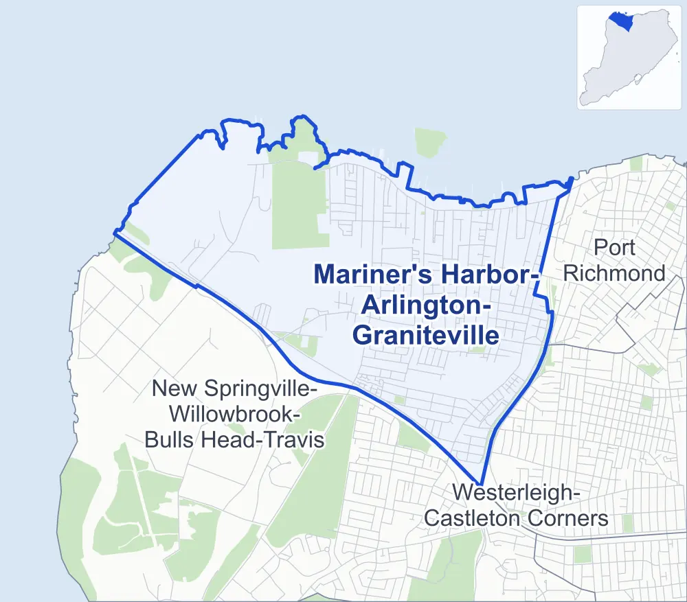
- Mariner's Harbor-Arlington-Graniteville
- A neighboring area
- Park
Neighborhood areas and streets: NYC Department of City Planning. Parks: NYC Parks. Stations: MTA.
Neighboring areas
- Port Richmond east
- Westerleigh-Castleton Corners southeast
- New Springville-Willowbrook-Bulls Head-Travis southwest
Getting around
Buses on 19 routes stop in or at the edge of Mariner's Harbor-Arlington-Graniteville.
- 10 local bus routes
- 9 express bus routes
Local bus routes
- S40
- S44
- S46
- S48
- S59
- S89
- S90
- S94
- S96
- S98
Express bus routes
- SIM3
- SIM3C
- SIM4
- SIM4C
- SIM8
- SIM30
- SIM33
- SIM33C
- SIM34
Safety record
Between 2021 and 2025, its corners averaged more police-reported crashes than the average Staten Island corner.
- 1,092 police-reported crashes at its corners
- 3.2 a corner, on average
- 2.2 the average Staten Island corner
- 113 corners with a clean record
Signal or safety changes on City record, at 29 of its corners
- Accessible pedestrian signals
- 29
- Leading pedestrian intervals
- 7
- Turn calming
- 3
- Safety Improvement Projects
- 1
Camera tickets
In 2025 its corners had more school-zone speed camera tickets than red-light or bus-lane tickets.
- 4,030 red-light camera tickets at two corners
- 61,532 school-zone speed camera tickets at 17 corners
- 0 bus-lane camera tickets
- Most red-light tickets
- Forest Avenue & South Avenue, 2,955
- Most speed tickets
- Forest Avenue & Willow Road West, 28,036
People and homes
The 2020 Census counted 33,492 residents in Mariner's Harbor-Arlington-Graniteville, about 10,400 per square mile.
- 11,207 homes, 2020 Census
- 288 homes added since April 2010, net, by City Planning's count
Half of its 5,607 residential lots hold buildings from 1975 or earlier, and 25% of them date from before 1940, by the City's tax lot records.
NYCHA development
NYCHA's Mariner's Harbor development lies wholly or partly within Mariner's Harbor-Arlington-Graniteville.
Parks and landmarks
- Parkland
- 44.8 acres of NYC Parks property
- The largest pieces
- Shooters Island (16.4 acres), Graniteville Swamp Park (9.2 acres) and Old Place Creek Park (6.9 acres)
- Designated landmark
- The Standard Varnish Works Factory Office Building
Streets and trees
- Trees
- 3,954 in NYC Parks' records, most often Callery pear, thornless honeylocust and Japanese flowering cherry
- Street with the most corners
- Richmond Terrace, with 32 of the area's 337
- Height above sea level
- From 4 feet at Goethals Community C-D Row & Goethals Community E-F Row to 65 feet at Eunice Place & Matthew Place
- Honorary street names
- 18 at its corners, enacted by local law
Schools and libraries
The City lists four schools and one library in Mariner's Harbor-Arlington-Graniteville.
- Public schools
- 4
- Library
- Mariners Harbor Library
Public safety
How complaints are countedIn 2025 the NYPD recorded 266 major felonies at places in Mariner's Harbor-Arlington-Graniteville.
Recorded by the NYPD at places in Mariner's Harbor-Arlington-Graniteville
- 219 major felonies in 2024
- 1,861 other felonies, misdemeanors and violations in 2025
- Police precinct
- 121st
From January to June 2026 the NYPD recorded 135 major felonies at places in Mariner's Harbor-Arlington-Graniteville, against 112 in the same months of 2025.
Sources: the NYPD's Complaint Data Historic, updated April 28, 2026, and Complaint Data Current (Year To Date), updated July 27, 2026, on NYC Open Data. Figures to June 30, 2026.
Street corners
- Ada Drive & Arlene Court
- Ada Drive & Elson Court
- Ada Drive & Farragut Avenue
- Ada Drive & Lenore Court
- Amador Street & Briarwood Road
- Amador Street & Knollwood Court
- Amity Place & Amador Street
- Amity Place & Wemple Street
- Andrea Place & Cedarwood Court
- Andros Avenue & Christopher Street
- Andros Avenue & Davidson Street
- Arlington Avenue & Arlington Place
- Arlington Avenue & Benjamin Place
- Arlington Place & Holland Avenue
- Benjamin Drive & Adrianne Lane
- Benjamin Drive & Carol Place
- Benjamin Drive & Doreen Drive
- Benjamin Drive & Eleanor Place
- Benjamin Drive & Francesca Lane
- Birch Road & Briarwood Road
- Birch Road & Knollwood Court
- Birch Road & Rosecliff Road
- Birch Road & Yale Street
- Bowles Avenue & Renfrew Place
- Brabant Street & Gridley Avenue
- Bruckner Avenue & Jupiter Lane
- Bush Avenue & Forest Court
- Comstock Avenue & Cooke Street
- Comstock Avenue & Domain Street
- Comstock Avenue & Lambert Street
- Comstock Avenue & Zeck Court
- Confederation Place & Gridley Avenue
- Continental Place & Andros Avenue
- Continental Place & Gridley Avenue
- Continental Place & Mersereau Avenue
- Coonley Court & Sylvan Place
- Cypress Crest Lane & Anita Street
- Cypress Crest Lane & Leo Street
- Cypress Crest Lane & Marc Street
- Cypress Crest Lane & Melissa Street
- Davidson Street & Davidson Court
- De Hart Avenue & Orinoco Place
- De Hart Avenue & Walloon Street
- Dixon Avenue & Pulaski Avenue
- Dr M L King Jr Expressway & Watchogue Road
- Erastina Place & Orinoco Place
- Eunice Place & Matthew Place
- Farraday Street & Madison Avenue
- Forest Avenue & Amity Place
- Forest Avenue & Bruckner Avenue
- Forest Avenue & Dwarf Street
- Forest Avenue & Eunice Place
- Forest Avenue & Goethals Road North (north-west)
- Forest Avenue & Goethals Road North (south-east)
- Forest Avenue & Goethals Road North at Staten Island Expressway
- Forest Avenue & Grandview Avenue
- Forest Avenue & Harbor Road
- Forest Avenue & Heaney Avenue
- Forest Avenue & Lake Avenue
- Forest Avenue & Lilac Court
- Forest Avenue & Maple Parkway
- Forest Avenue & Morrow Street (north-east)
- Forest Avenue & Morrow Street (south-west)
- Forest Avenue & Northfield Avenue
- Forest Avenue & Samuel Place
- Forest Avenue & Sanders Street
- Forest Avenue & Simonson Avenue
- Forest Avenue & South Avenue
- Forest Avenue & Summerfield Place
- Forest Avenue & Union Avenue
- Forest Avenue & Van Name Avenue
- Forest Avenue & Van Pelt Avenue
- Forest Avenue & Willow Road West
- Goethals Community C-D Row & Goethals Community A-B Row
- Goethals Community C-D Row & Goethals Community E-F Row
- Goethals Road North & Cooke Street
- Goethals Road North & Domain Street
- Goethals Road North & Farragut Avenue
- Goethals Road North & Goethals Bridge Bike Path
- Goethals Road North & Goethals Community A-B Row
- Goethals Road North & Goethals Community C-D Row
- Goethals Road North & Goethals Community E-F Row
- Goethals Road North & Goethals Community G-H Row
- Goethals Road North & Jules Drive
- Goethals Road North & Lambert Street
- Goethals Road North & Staten Island Expressway (Exit 3)
- Goethals Road North & Staten Island Expressway (Exit 6)
- Goethals Road North & Staten Island Expressway (Forest Avenue)
- Goethals Road North & Staten Island Expressway (Richmond Avenue)
- Goethals Road North & Western Avenue
- Grandview Avenue & Arlington Place
- Grandview Avenue & Brabant Street
- Grandview Avenue & Christopher Street
- Grandview Avenue & Continental Place
- Grandview Avenue & Cowen Place
- Grandview Avenue & Davidson Street
- Grandview Avenue & Downey Place
- Grandview Avenue & Netherland Avenue
- Grandview Avenue & Richmond Court
- Granite Avenue & David Place
- Granite Avenue & Dixon Avenue
- Granite Avenue & Hooker Place
- Granite Avenue & La Salle Street
- Granite Avenue & Princess Street
- Granite Avenue & Ronald Avenue
- Harbor Road & Brabant Street
- Harbor Road & Breezy Court
- Harbor Road & Confederation Place
- Harbor Road & Continental Place
- Harbor Road & Destiny Court
- Harbor Road & Dublin Place
- Harbor Road & Leyden Avenue
- Harbor Road & Netherland Avenue
- Heaney Avenue & Jupiter Lane
- Holiday Drive & Holiday Way
- Holiday Drive & Jamie Court
- Holiday Drive & Lynn Court
- Holiday Drive & Tiger Court
- Holland Avenue & Benjamin Place
- Holland Avenue & Macormac Place
- Housman Avenue & Gigi Street
- Housman Avenue & La Salle Street
- Jules Drive & Arlene Court
- Jules Drive & Comstock Avenue
- Jules Drive & Comstock Avenue at Lenore Court
- Jules Drive & Elson Court
- Kinsey Place & Dolson Place
- Kinsey Place & Woodcliff Avenue
- La Salle Street & Shaina Court
- Lake Avenue & Dixon Avenue
- Lake Avenue & Ronald Avenue
- Lake Avenue & Walker Street
- Lake Avenue & Wenlock Street
- Lake Avenue & Westbrook Avenue
- Lisk Avenue & Selvin Loop (east)
- Lisk Avenue & Selvin Loop (west)
- Lisk Avenue & Wolkoff Lane
- Lockman Avenue & Brabant Street
- Lockman Avenue & Continental Place
- Lockman Avenue & Harbor Loop
- Lockman Avenue & Lockman Loop
- Lockman Avenue & Lockman Place
- Ludwig Lane & Amity Place
- Maple Parkway & De Ruyter Place
- Maple Parkway & Spirit Lane
- Maple Parkway & Walloon Street
- Mariners Lane & Harbor Lane
- Mersereau Avenue & Christopher Street
- Mersereau Avenue & Davidson Street
- Mersereau Avenue & Downey Place
- Mersereau Avenue & Spartan Avenue
- Mersereau Avenue & Wemple Street
- Morningstar Road & David Place
- Morningstar Road & Dixon Avenue
- Morningstar Road & Dr M L King Jr Expressway
- Morningstar Road & Hooker Place
- Morningstar Road & Innis Street
- Morningstar Road & Kalver Place
- Morningstar Road & Newark Avenue
- Morningstar Road & Ronald Avenue
- Morningstar Road & St Adalbert Place
- Morningstar Road & Walker Street
- Morningstar Road & Wenlock Street
- Morningstar Road & Westbrook Avenue
- Morrow Street & Elizabeth Grove Road
- Netherland Avenue & Andros Avenue
- Netherland Avenue & Lockman Avenue
- Netherland Avenue & Maple Parkway
- Netherland Avenue & Mersereau Avenue
- Netherland Avenue & Simonson Avenue
- Netherland Avenue & Union Avenue
- Netherland Avenue & Van Pelt Avenue
- Northfield Avenue & Arlington Place
- Northfield Avenue & Bailey Place
- Northfield Avenue & Benjamin Place
- Northfield Avenue & Fancher Place
- Northfield Avenue & Kinsey Place
- Northfield Avenue & Macormac Place
- Northfield Avenue & Martineau Street
- Pond Way & Arlington Place (east)
- Pond Way & Arlington Place (west)
- Post Lane & Cowen Place
- Pulaski Avenue & David Place
- Pulaski Avenue & Hooker Place
- Pulaski Avenue & Kalver Place
- Pulaski Avenue & Ronald Avenue
- Regal Walk & Farragut Avenue
- Regis Drive & Arlene Court
- Regis Drive & Elson Court
- Regis Drive & Farragut Avenue
- Regis Drive & Lenore Court
- Renfrew Place & Murdock Place
- Richmond Avenue & Ada Drive
- Richmond Avenue & Anita Street
- Richmond Avenue & Deppe Place
- Richmond Avenue & Forest Avenue
- Richmond Avenue & Goethals Road North
- Richmond Avenue & Holiday Way
- Richmond Avenue & Jules Drive
- Richmond Avenue & Madan Court
- Richmond Avenue & Marc Street
- Richmond Avenue & Melissa Street
- Richmond Avenue & Monsey Place
- Richmond Avenue & Morningstar Road
- Richmond Avenue & Peter Street
- Richmond Avenue & Regis Drive
- Richmond Avenue & Renfrew Place
- Richmond Avenue & Staten Island Expressway
- Richmond Avenue & Sumner Avenue
- Richmond Avenue & Vedder Avenue
- Richmond Avenue & Willow Road West
- Richmond Terrace & Andros Avenue
- Richmond Terrace & Arlington Avenue
- Richmond Terrace & Betty Court
- Richmond Terrace & Bush Avenue
- Richmond Terrace & Catherine Place
- Richmond Terrace & Coonley Court
- Richmond Terrace & De Hart Avenue
- Richmond Terrace & Emeric Court
- Richmond Terrace & Federal Place
- Richmond Terrace & Giordan Court
- Richmond Terrace & Grandview Avenue
- Richmond Terrace & Granite Avenue
- Richmond Terrace & Harbor Road
- Richmond Terrace & Holland Avenue
- Richmond Terrace & Housman Avenue
- Richmond Terrace & Lake Avenue
- Richmond Terrace & Lockman Avenue
- Richmond Terrace & Mariners Lane
- Richmond Terrace & Mersereau Avenue
- Richmond Terrace & Morningstar Road
- Richmond Terrace & Northfield Avenue
- Richmond Terrace & Northfield Court
- Richmond Terrace & Post Lane
- Richmond Terrace & Richmond Court
- Richmond Terrace & Simonson Avenue
- Richmond Terrace & South Avenue
- Richmond Terrace & Union Avenue
- Richmond Terrace & Van Name Avenue
- Richmond Terrace & Van Pelt Avenue
- Richmond Terrace & Western Avenue
- Richmond Terrace & Winant Street
- Richmond Terrace & Wright Avenue
- Rosecliff Road & Albert Court
- Sanders Street & Monsey Place
- Simonson Avenue & Dixon Avenue
- Simonson Avenue & Heusden Street
- Simonson Avenue & Walker Street
- Simonson Avenue & Wenlock Street
- South Avenue & Amador Street
- South Avenue & Arlington Place
- South Avenue & Brabant Street
- South Avenue & Cable Way
- South Avenue & Continental Place
- South Avenue & Goethals Road North
- South Avenue & Lisk Avenue
- South Avenue & Netherland Avenue
- South Avenue & Regal Walk
- South Avenue & Wemple Street
- South Avenue & Wolkoff Lane
- Spartan Avenue & Rosecliff Road
- Spartan Avenue & Yale Street
- Staten Island Expressway & Western Avenue
- Sumner Avenue & Farraday Street
- Union Avenue & Brabant Street
- Union Avenue & Confederation Place
- Union Avenue & Continental Place
- Union Avenue & Forest Court
- Union Avenue & Journeay Street
- Union Avenue & Leyden Avenue
- Union Avenue & Spirit Lane
- Union Avenue & Sylvan Place
- Union Avenue & Union Court
- Union Avenue & Walloon Street
- Van Name Avenue & Avalon Court
- Van Name Avenue & Beamer Court
- Van Name Avenue & Cecil Court
- Van Name Avenue & Charles Place
- Van Name Avenue & Heusden Street
- Van Name Avenue & Kion Way
- Van Name Avenue & Laguna Lane
- Van Name Avenue & Letty Court
- Van Name Avenue & Mariners Lane
- Van Name Avenue & Michelle Court
- Van Name Avenue & Netherland Avenue
- Van Name Avenue & Noah Court
- Van Name Avenue & Nunzie Court
- Van Name Avenue & Serenity Way
- Van Name Avenue & Walker Street
- Van Name Avenue & Wilcox Street
- Van Pelt Avenue & De Ruyter Place
- Van Pelt Avenue & Heusden Street
- Van Pelt Avenue & Laguna Lane
- Van Pelt Avenue & Montana Court
- Vedder Avenue & Holiday Drive
- Walker Street & Granite Avenue
- Walker Street & Pulaski Avenue
- Walker Street & Van Pelt Avenue
- Walker Street & Walker Drive
- Wenlock Street & Hudson Place
- Wenlock Street & Melyn Place
- West Caswell Avenue & Farraday Street
- Westbrook Avenue & Hudson Place
- Westbrook Avenue & Melyn Place
- Western Avenue & Goethals Bridge Bike Path
- Wilcox Street & Adrianne Lane
- Wilcox Street & Amity Place
- Wilcox Street & Bruckner Avenue
- Wilcox Street & Carol Place
- Wilcox Street & Claudia Court
- Wilcox Street & Doreen Drive
- Wilcox Street & Eleanor Place
- Wilcox Street & Eunice Place
- Wilcox Street & Francesca Lane
- Wilcox Street & Heaney Avenue
- Wilcox Street & Heather Court
- Wilcox Street & Matthew Place
- Wilcox Street & Sanders Street
- Willow Road West & Bowles Avenue
- Willow Road West & Dixon Avenue
- Willow Road West & Dr M L King Expressway
- Willow Road West & Dr M L King Jr Expressway
- Willow Road West & Farraday Street
- Willow Road West & Leonard Street
- Willow Road West & Madison Avenue
- Willow Road West & Murdock Place
- Willow Road West & Rodman Street
- Willow Road West & Sumner Avenue (east)
- Willow Road West & Sumner Avenue (west)
- Willow Road West & Vedder Avenue
- Willow Road West & Watchogue Road
- Willow Road West & West Caswell Avenue
- Winant Street & La Salle Street
- Wolkoff Lane & Selvin Loop
- Woodcrest Road & Albert Court
- Wright Avenue & Gigi Street
- Yale Street & Cedarwood Court
How the figures above are measured: Methodology.