Inwood
Neighborhood · Manhattan
Inwood forms the northern tip of Manhattan, north of Washington Heights, between Inwood Hill Park and the Harlem River.
- 0.52 square miles
- 36,299 residents, 2020 Census
- 89 street corners
- 4 subway stations
- 6 bus routes
The Dyckman family's farm of 250 to 280 acres lay along today's Broadway until its land was sold at four auctions between 1868 and 1871, and their Dutch Colonial farmhouse, built around 1785 on Broadway at 204th Street, is the oldest remaining farmhouse on Manhattan island and has been a museum since 1916. Apartment buildings went up east of Broadway after the IRT subway arrived in 1906, and Columbia University has kept its 23-acre athletic complex here since the 1920s.
Sources: Inwood, Manhattan (Wikipedia); Dyckman House (Wikipedia); The Dyckman Family (Dyckman Farmhouse Museum); The Museum (Dyckman Farmhouse Museum).
Inwood borders three areas, and 10th Avenue holds more of its corners than any other street, 20 of 89.
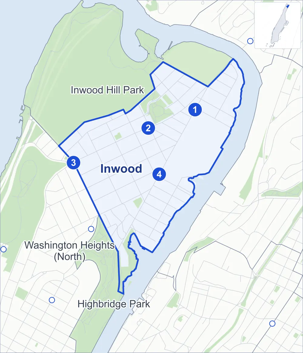
- Inwood
- A neighboring area
- Park
- A station in the list
- Another station
Neighborhood areas and streets: NYC Department of City Planning. Parks: NYC Parks. Stations: MTA.
Neighboring areas
- Inwood Hill Park north
- Highbridge Park south
- Washington Heights (North) west
Subway stations
- 215 St lines 1
- Inwood-207 St lines A accessible
- Dyckman St lines A
- 207 St lines 1
Getting around
Four subway stations and buses on six routes stop in or at the edge of Inwood.
- 4 subway stations
- 1 of them listed by the MTA as fully accessible
- 5 local bus routes
- 1 express bus route
Local bus routes
- Bx7
- Bx12
- Bx12-SBS
- Bx20
- M100
Express bus route
- BxM1
Safety record
Between 2021 and 2025, its corners averaged more police-reported crashes than the average Manhattan corner.
- 1,645 police-reported crashes at its corners
- 18.5 a corner, on average
- 13.4 the average Manhattan corner
- 4 corners with a clean record
Signal or safety changes on City record, at 21 of its corners
- Leading pedestrian intervals
- 13
- Accessible pedestrian signals
- 11
- Turn calming
- 3
- Barnes Dance all-way crossings
- 2
- Safety Improvement Projects
- 2
- Enhanced crossings
- 1
Camera tickets
In 2025 its corners had more school-zone speed camera tickets than bus-lane or red-light tickets.
- 71 red-light camera tickets at one corner
- 13,170 school-zone speed camera tickets at five corners
- 580 bus-lane camera tickets at one corner
- Most red-light tickets
- 10th Avenue & West 207th Street, 71
- Most speed tickets
- Broadway & 9th Avenue, 9,519
- Most bus-lane tickets
- West 207th Street & Vermilyea Avenue, 580
People and homes
The 2020 Census counted 36,299 residents in Inwood, about 69,800 per square mile.
- 15,712 homes, 2020 Census
- 2,028 homes added since April 2010, net, by City Planning's count
Half of its 367 residential lots hold buildings from 1926 or earlier, and 83% of them date from before 1940, by the City's tax lot records.
NYCHA development
NYCHA's Dyckman development lies wholly or partly within Inwood.
Parks and landmarks
- Parkland
- 18.3 acres of NYC Parks property
- The largest pieces
- Isham Park (9.7 acres), Sherman Creek (7.1 acres) and Monsignor Kett Playground (1 acre)
- Designated landmark
- The Dyckman House
- Historic district
- Park Terrace West-West 217th Street Historic District, wholly or partly within Inwood
Streets and trees
- Trees
- 2,173 in NYC Parks' records, most often thornless honeylocust, Japanese zelkova and maidenhair tree
- Street with the most corners
- 10th Avenue, with 20 of the area's 89
- Height above sea level
- From 6 feet at Nagle Avenue & Academy Street to 95 feet at West 215th Street & Park Terrace East
- Honorary street names
- 24 at its corners, enacted by local law
Schools and libraries
The City lists 20 schools and one library in Inwood.
- Public schools
- 10
- Charter and private schools
- 10
- Library
- Inwood Library–joseph and Sheila Rosenblatt Building
Bike share
By the station list of October 3, 2026, 13 bike-share stations stand in Inwood.
- 13 bike-share stations
Public safety
How complaints are countedIn 2025 the NYPD recorded 451 major felonies at places in Inwood.
Recorded by the NYPD at places in Inwood
- 452 major felonies in 2024
- 1,872 other felonies, misdemeanors and violations in 2025
In 2025, on the streets along the edge of Inwood, the NYPD recorded another 111 major felonies. Counting the streets along its edge, in 2025 the NYPD recorded 15.5 major felonies for every thousand residents the 2020 Census counted in Inwood.
- Police precinct
- 34th
From January to June 2026 the NYPD recorded 229 major felonies at places in Inwood, against 218 in the same months of 2025.
Sources: the NYPD's Complaint Data Historic, updated April 28, 2026, and Complaint Data Current (Year To Date), updated July 27, 2026, on NYC Open Data. Figures to June 30, 2026.
Street corners
- 9th Avenue & West 201st Street
- 9th Avenue & West 202nd Street
- 9th Avenue & West 203rd Street
- 9th Avenue & West 204th Street
- 9th Avenue & West 205th Street
- 9th Avenue & West 206th Street
- 9th Avenue & West 207th Street
- 9th Avenue & West 215th Street
- 9th Avenue & West 216th Street
- 9th Avenue & West 218th Street
- 9th Avenue & West 219th Street
- 9th Avenue & West 220th Street
- 10th Avenue & Academy Street
- 10th Avenue & Isham Street
- 10th Avenue & Nagle Avenue
- 10th Avenue & Post Avenue
- 10th Avenue & Sherman Avenue
- 10th Avenue & West 201st Street
- 10th Avenue & West 202nd Street
- 10th Avenue & West 203rd Street
- 10th Avenue & West 204th Street
- 10th Avenue & West 205th Street
- 10th Avenue & West 206th Street
- 10th Avenue & West 207th Street
- 10th Avenue & West 211th Street
- 10th Avenue & West 212th Street
- 10th Avenue & West 213th Street
- 10th Avenue & West 214th Street
- 10th Avenue & West 215th Street
- 10th Avenue & West 216th Street
- 10th Avenue & West 218th Street
- Academy Street & Cooper Street
- Academy Street & Post Avenue
- Academy Street & Sherman Avenue
- Academy Street & Vermilyea Avenue
- Academy Street & West 201st Street
- Broadway & 9th Avenue
- Broadway & Academy Street
- Broadway & Cumming Street
- Broadway & Isham Street
- Broadway & Riverside Drive at Dyckman Street
- Broadway & West 204th Street
- Broadway & West 207th Street
- Broadway & West 212th Street
- Broadway & West 213th Street
- Broadway & West 214th Street
- Broadway & West 215th Street
- Broadway & West 216th Street
- Broadway & West 218th Street
- Broadway & West 219th Street
- Broadway & West 220th Street
- Dyckman Street & Nagle Avenue
- Dyckman Street & Vermilyea Avenue
- Harlem River Driveway & 10th Avenue
- Isham Street & Cooper Street
- Nagle Avenue & Academy Street
- Park Terrace East & West 217th Street
- Park Terrace West & West 214th Street
- Park Terrace West & West 217th Street
- Payson Avenue & Beak Street
- Seaman Avenue & Academy Street
- Seaman Avenue & Beak Street
- Seaman Avenue & Cumming Street
- Seaman Avenue & Isham Street
- Seaman Avenue & Payson Avenue
- Seaman Avenue & West 207th Street
- Seaman Avenue & West 214th Street
- Sherman Avenue & Isham Street
- Sherman Avenue & West 207th Street
- University Heights Bridge & 9th Avenue
- Vermilyea Avenue & Isham Street
- Vermilyea Avenue & West 211th Street
- West 204th Street & Cooper Street
- West 204th Street & Nagle Avenue
- West 204th Street & Post Avenue
- West 204th Street & Seaman Avenue
- West 204th Street & Sherman Avenue
- West 204th Street & Vermilyea Avenue
- West 207th Street & Cooper Street
- West 207th Street & Post Avenue
- West 207th Street & Vermilyea Avenue
- West 215th Street & Indian Road
- West 215th Street & Park Terrace East
- West 215th Street & Park Terrace West
- West 215th Street & Seaman Avenue
- West 218th Street & Indian Road
- West 218th Street & Park Terrace East
- West 218th Street & Park Terrace West
- West 218th Street & Seaman Avenue
How the figures above are measured: Methodology.