Cambria Heights
Neighborhood · Queens
Cambria Heights occupies the southeastern edge of Queens along the Nassau County line, with Queens Village to the north and St. Albans to the west.
- 1.19 square miles
- 19,081 residents, 2020 Census
- 230 street corners
- 7 bus routes
Its name, coined in the mid-1920s, was borrowed from a company based in Cambria County, Pennsylvania, that financed the early building. In 2022 the city designated two historic districts on 222nd and 227th Streets, protecting 96 storybook-style row houses with Tudor details built in 1931. Black families began settling here by the 1950s and by the 1980s were joined by families from Jamaica, Haiti, Trinidad and Tobago, Guyana and Barbados.
Sources: LPC Designates Two Historic Districts In Queens (NYC Landmarks Preservation Commission); Cambria Heights, Queens (Wikipedia).
Cambria Heights borders five areas, and 120th Avenue holds more of its corners than any other street, 24 of 230.
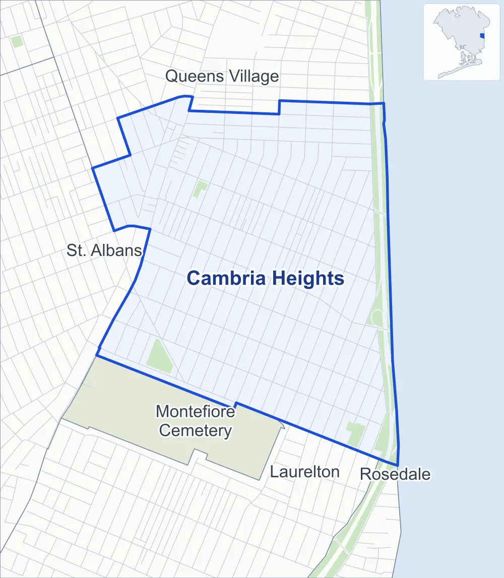
- Cambria Heights
- A neighboring area
- Park
Neighborhood areas and streets: NYC Department of City Planning. Parks: NYC Parks. Stations: MTA.
Neighboring areas
- Queens Village north
- Rosedale southeast
- Laurelton south
- Montefiore Cemetery southwest
- St. Albans west
Getting around
Buses on seven routes stop in or at the edge of Cambria Heights.
- 6 local bus routes
- 1 express bus route
Local bus routes
- Q4
- Q27
- Q51
- Q77
- Q83
- Q84
Express bus route
- QM64
Safety record
Between 2021 and 2025, its corners averaged fewer police-reported crashes than the average Queens corner.
- 1,012 police-reported crashes at its corners
- 4.4 a corner, on average
- 5.2 the average Queens corner
- 33 corners with a clean record
Signal or safety changes on City record, at 16 of its corners
- Leading pedestrian intervals
- 15
- Accessible pedestrian signals
- 5
- Barnes Dance all-way crossings
- 1
Camera tickets
In 2025 its corners had more school-zone speed camera tickets than red-light or bus-lane tickets.
- 0 red-light camera tickets
- 17,813 school-zone speed camera tickets at 13 corners
- 0 bus-lane camera tickets
- Most speed tickets
- Francis Lewis Boulevard & 116th Avenue, 3,752
People and homes
The 2020 Census counted 19,081 residents in Cambria Heights, about 16,000 per square mile.
- 6,363 homes, 2020 Census
- 7 homes added since April 2010, net, by City Planning's count
Half of its 5,185 residential lots hold buildings from 1945 or earlier, and 21% of them date from before 1940, by the City's tax lot records.
NYCHA developments
NYCHA's FHA Repossessed Houses (Group IV), FHA Repossessed Houses (Group II) and FHA Repossessed Houses (Group III) developments lie wholly or partly within Cambria Heights.
- FHA Repossessed Houses (Group IV)
- Partly within Cambria Heights
- FHA Repossessed Houses (Group II)
- Partly within Cambria Heights
- FHA Repossessed Houses (Group III)
- Partly within Cambria Heights
Parks and landmarks
- Parkland
- 8.6 acres of NYC Parks property
- The largest pieces
- Cambria Playground (4.7 acres), Delphin H. Greene Playground (2.8 acres) and East Springfield Playground (1.1 acres)
- Historic districts
- Cambria Heights-222nd Street and Cambria Heights-227th Street, wholly or partly within Cambria Heights
Streets and trees
- Trees
- 3,609 in NYC Parks' records, most often London planetree, Callery pear and pin oak
- Street with the most corners
- 120th Avenue, with 24 of the area's 230
- Height above sea level
- From 35 feet at Springfield Boulevard & 120th Avenue to 63 feet at 228th Street & 114th Drive
- Honorary street names
- 8 at its corners, enacted by local law
Schools and libraries
The City lists 11 schools and one library in Cambria Heights.
- Public schools
- 6
- Charter and private schools
- 5
- Library
- Cambria Heights Library
Public safety
How complaints are countedIn 2025 the NYPD recorded 119 major felonies at places in Cambria Heights.
Recorded by the NYPD at places in Cambria Heights
- 117 major felonies in 2024
- 680 other felonies, misdemeanors and violations in 2025
In 2025, on the streets along the edge of Cambria Heights, the NYPD recorded another 24 major felonies. Counting the streets along its edge, in 2025 the NYPD recorded 7.5 major felonies for every thousand residents the 2020 Census counted in Cambria Heights.
- Police precinct
- 105th
From January to June 2026 the NYPD recorded 53 major felonies at places in Cambria Heights, against 55 in the same months of 2025.
Sources: the NYPD's Complaint Data Historic, updated April 28, 2026, and Complaint Data Current (Year To Date), updated July 27, 2026, on NYC Open Data. Figures to June 30, 2026.
Street corners
- 115th Avenue & 114th Road
- 115th Avenue & 207th Street
- 115th Avenue & 209th Street
- 115th Avenue & 211th Street
- 115th Avenue & 218th Street
- 115th Avenue & 219th Street
- 115th Avenue & 224th Street
- 115th Avenue & 225th Street
- 115th Avenue & 226th Street
- 115th Avenue & 227th Street
- 115th Avenue & 228th Street
- 115th Avenue & 229th Street
- 115th Avenue & 230th Street
- 115th Avenue & 231st Street
- 115th Avenue & Nashville Boulevard
- 115th Road & Nashville Boulevard
- 116th Avenue & 207th Street
- 116th Avenue & 208th Street
- 116th Avenue & 217th Street
- 116th Avenue & 218th Street
- 116th Avenue & 219th Street
- 116th Avenue & 222nd Street
- 116th Avenue & 224th Street
- 116th Avenue & 225th Street
- 116th Avenue & 226th Street
- 116th Avenue & 227th Street
- 116th Avenue & 228th Street
- 116th Avenue & 229th Street
- 116th Avenue & 230th Street
- 116th Avenue & 231st Street
- 116th Avenue & 232nd Street
- 116th Avenue & 233rd Street
- 116th Avenue & Nashville Boulevard
- 118th Avenue & 235th Street
- 119th Avenue & 233rd Street
- 119th Avenue & 234th Street
- 119th Avenue & 235th Street
- 119th Avenue & 236th Street
- 119th Avenue & 237th Street
- 120th Avenue & 225th Street
- 120th Avenue & 226th Street
- 120th Avenue & 227th Street
- 120th Avenue & 228th Street
- 120th Avenue & 229th Street
- 120th Avenue & 231st Street
- 120th Avenue & 232nd Street
- 120th Avenue & 233rd Street
- 120th Avenue & 234th Street
- 120th Avenue & 235th Street
- 120th Avenue & 236th Street
- 120th Avenue & 237th Street
- 120th Avenue & 238th Street
- 121st Avenue & 235th Street
- 121st Avenue & 238th Street
- 209th Street & Nashville Boulevard
- 210th Street & 115th Avenue
- 210th Street & Nashville Boulevard
- 211th Street & Murdock Avenue
- 212th Street & Colfax Street
- 212th Street & Murdock Avenue
- 212th Street & Nashville Boulevard
- 217th Street & 114th Road
- 217th Street & 115th Avenue
- 217th Street & 115th Road
- 217th Street & 120th Avenue
- 217th Street & 121st Avenue
- 218th Street & 115th Road
- 218th Street & 118th Avenue
- 218th Street & 119th Avenue
- 218th Street & 120th Avenue
- 218th Street & 121st Avenue
- 219th Street & 113th Drive
- 219th Street & 114th Avenue
- 219th Street & 114th Road
- 219th Street & 115th Road
- 219th Street & 117th Road
- 219th Street & 118th Avenue
- 219th Street & 119th Avenue
- 219th Street & 120th Avenue
- 219th Street & 121st Avenue
- 220th Street & 114th Road
- 220th Street & 115th Avenue
- 220th Street & 115th Road
- 220th Street & 116th Avenue
- 220th Street & 118th Avenue
- 220th Street & 119th Avenue
- 220th Street & 120th Avenue
- 221st Street & 114th Avenue
- 221st Street & 114th Road
- 221st Street & 115th Avenue
- 221st Street & 115th Road
- 221st Street & 116th Avenue
- 221st Street & 118th Avenue
- 221st Street & 119th Avenue
- 221st Street & 120th Avenue
- 222nd Street & 114th Road
- 222nd Street & 115th Avenue
- 222nd Street & 115th Road
- 222nd Street & 118th Avenue
- 222nd Street & 119th Avenue
- 222nd Street & 120th Avenue
- 222nd Street & 121st Avenue
- 223rd Street & 113th Drive
- 223rd Street & 114th Avenue
- 223rd Street & 114th Road
- 223rd Street & 115th Avenue
- 223rd Street & 115th Road
- 223rd Street & 116th Avenue
- 223rd Street & 118th Avenue
- 223rd Street & 119th Avenue
- 223rd Street & 120th Avenue
- 223rd Street & Murdock Avenue
- 224th Street & 114th Road
- 224th Street & 115th Road
- 224th Street & 118th Avenue
- 224th Street & 119th Avenue
- 224th Street & 120th Avenue
- 225th Street & 113th Drive
- 225th Street & 114th Avenue
- 225th Street & 114th Road
- 225th Street & 115th Road
- 225th Street & 118th Avenue
- 225th Street & 119th Avenue
- 226th Street & 114th Road
- 226th Street & 115th Road
- 226th Street & 118th Avenue
- 226th Street & 119th Avenue
- 227th Street & 113th Drive
- 227th Street & 114th Avenue
- 227th Street & 114th Drive
- 227th Street & 114th Road
- 227th Street & 115th Road
- 227th Street & 118th Avenue
- 227th Street & 119th Avenue
- 227th Street & Murdock Avenue
- 228th Street & 114th Drive
- 228th Street & 114th Terrace
- 228th Street & 115th Road
- 228th Street & 118th Avenue
- 228th Street & 119th Avenue
- 229th Street & 114th Terrace
- 229th Street & 115th Road
- 229th Street & 118th Avenue
- 229th Street & 119th Avenue
- 230th Street & 114th Terrace
- 230th Street & 115th Road
- 230th Street & 118th Avenue
- 230th Street & 119th Avenue
- 230th Street & 120th Avenue
- 231st Street & 115th Road
- 231st Street & 118th Avenue
- 231st Street & 119th Avenue
- 232nd Street & 115th Road
- 232nd Street & 118th Avenue
- 232nd Street & 119th Avenue
- 232nd Street & 121st Avenue
- 233rd Street & 118th Avenue
- 233rd Street & 121st Avenue
- 234th Street & 118th Avenue
- 234th Street & Cross Island Parkway
- Cross Island Parkway & 113th Drive
- Cross Island Parkway & 114th Avenue
- Cross Island Parkway & 114th Drive
- Cross Island Parkway & 114th Road
- Cross Island Parkway & 114th Terrace
- Cross Island Parkway & 115th Avenue
- Cross Island Parkway & 115th Road
- Cross Island Parkway & 116th Avenue
- Cross Island Parkway & 118th Avenue
- Cross Island Parkway & 119th Avenue
- Cross Island Parkway & 231st Street
- Cross Island Parkway & 232nd Street
- Cross Island Parkway & 233rd Street
- Cross Island Parkway & 235th Street
- Cross Island Parkway & 236th Street
- Cross Island Parkway & 237th Street
- Cross Island Parkway & Belt Parkway
- Cross Island Parkway & Cip
- Cross Island Parkway & Linden Boulevard
- Cross Island Parkway & Linden Boulevard (Linden Boulevard)
- Cross Island Parkway & Murdock Avenue
- Francis Lewis Boulevard & 115th Road
- Francis Lewis Boulevard & 116th Avenue
- Francis Lewis Boulevard & 119th Avenue
- Francis Lewis Boulevard & 120th Avenue
- Francis Lewis Boulevard & 121st Avenue
- Francis Lewis Boulevard & 217th Street
- Francis Lewis Boulevard & 218th Street
- Francis Lewis Boulevard & 219th Street
- Francis Lewis Boulevard & 222nd Street
- Francis Lewis Boulevard & 223rd Street
- Francis Lewis Boulevard & 224th Street
- Francis Lewis Boulevard & 225th Street
- Francis Lewis Boulevard & 226th Street
- Francis Lewis Boulevard & 227th Street
- Francis Lewis Boulevard & 229th Street
- Francis Lewis Boulevard & 231st Street
- Linden Boulevard & 217th Street
- Linden Boulevard & 218th Street
- Linden Boulevard & 219th Street
- Linden Boulevard & 220th Street
- Linden Boulevard & 221st Street
- Linden Boulevard & 222nd Street
- Linden Boulevard & 223rd Street
- Linden Boulevard & 224th Street
- Linden Boulevard & 225th Street
- Linden Boulevard & 226th Street
- Linden Boulevard & 227th Street
- Linden Boulevard & 228th Street
- Linden Boulevard & 229th Street
- Linden Boulevard & 230th Street
- Linden Boulevard & 231st Street
- Linden Boulevard & 232nd Street
- Linden Boulevard & 233rd Street
- Linden Boulevard & 234th Street
- Linden Boulevard & Nashville Boulevard
- Murdock Avenue & Colfax Street
- Murdock Avenue & Delevan Street
- Murdock Avenue & Nashville Boulevard
- Nashville Boulevard & 116th Road
- Nashville Boulevard & Colfax Street
- Springfield Boulevard & 114th Avenue
- Springfield Boulevard & 114th Road
- Springfield Boulevard & 115th Avenue
- Springfield Boulevard & 115th Road
- Springfield Boulevard & 116th Avenue
- Springfield Boulevard & 118th Avenue
- Springfield Boulevard & 120th Avenue
- Springfield Boulevard & Colfax Street
- Springfield Boulevard & Linden Boulevard
How the figures above are measured: Methodology.