Rosedale
Neighborhood · Queens
At the eastern edge of New York City, Rosedale borders Laurelton, Springfield Gardens and Kennedy Airport on the west and the Nassau County communities of Valley Stream, North Woodmere, Inwood and Lawrence on the east and south.
- 1.69 square miles
- 27,101 residents, 2020 Census
- 314 street corners
- 10 bus routes
It was first known as Foster's Meadow, after John Foster, an early British settler, and much of it remained farmland until the mid-1930s. Brookville Park, 90 acres along the neighborhood's western edge, holds Conselyea's Pond in its landscaped section and wild, undeveloped land to the south.
Sources: Rosedale, Queens (Wikipedia); Rosedale: Queens' Beginning and End (Brownstoner); Brookville Park and the Ghost Train (Brownstoner).
Rosedale borders four areas, and Hook Creek Boulevard holds more of its corners than any other street, 39 of 314.
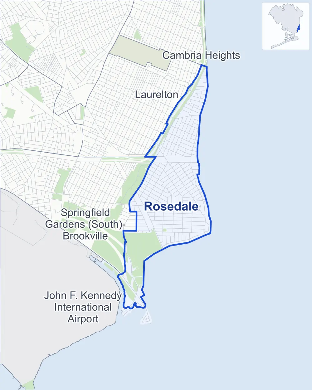
- Rosedale
- A neighboring area
- Park
Neighborhood areas and streets: NYC Department of City Planning. Parks: NYC Parks. Stations: MTA.
Neighboring areas
- Laurelton north
- Cambria Heights north
- Springfield Gardens (South)-Brookville southwest
- John F. Kennedy International Airport southwest
Getting around
Buses on ten routes stop in or at the edge of Rosedale.
- 9 local bus routes
- 1 express bus route
Local bus routes
- Q5
- Q84
- Q85
- Q86
- Q87
- Q89
- Q111
- Q113
- Q114
Express bus route
- QM63
Safety record
Between 2021 and 2025, its corners averaged fewer police-reported crashes than the average Queens corner.
- 1,551 police-reported crashes at its corners
- 4.9 a corner, on average
- 5.2 the average Queens corner
- 71 corners with a clean record
Signal or safety changes on City record, at eight of its corners
- Accessible pedestrian signals
- 6
- Leading pedestrian intervals
- 5
- Turn calming
- 2
Camera tickets
In 2025 its corners had more school-zone speed camera tickets than red-light or bus-lane tickets.
- 4,401 red-light camera tickets at two corners
- 57,072 school-zone speed camera tickets at 19 corners
- 0 bus-lane camera tickets
- Most red-light tickets
- Rockaway Boulevard & Brookville Boulevard, 3,551
- Most speed tickets
- South Conduit Avenue & Memphis Avenue, 24,126
People and homes
The 2020 Census counted 27,101 residents in Rosedale, about 16,000 per square mile.
- 8,709 homes, 2020 Census
- 235 homes added since April 2010, net, by City Planning's count
Half of its 5,167 residential lots hold buildings from 1950 or earlier, and 27% of them date from before 1940, by the City's tax lot records.
Parks
- Parkland
- 145.6 acres of NYC Parks property
- The largest pieces
- Hook Creek Park (111.2 acres), Idlewild Park (31.4 acres) and Laurelton Playground (2 acres)
Streets and trees
- Trees
- 5,245 in NYC Parks' records, most often thornless honeylocust, London planetree and Norway maple
- Street with the most corners
- Hook Creek Boulevard, with 39 of the area's 314
- Height above sea level
- From 2 feet at 1st Street & Meyer Avenue to 41 feet at Hook Creek Boulevard & 128th Drive
- Honorary street names
- 5 at its corners, enacted by local law
Schools and libraries
The City lists seven schools and one library in Rosedale.
- Public schools
- 3
- Charter and private schools
- 4
- Library
- Rosedale Library
Public safety
How complaints are countedIn 2025 the NYPD recorded 223 major felonies at places in Rosedale.
Recorded by the NYPD at places in Rosedale
- 223 major felonies in 2024
- 1,005 other felonies, misdemeanors and violations in 2025
In 2025, on the streets along the edge of Rosedale, the NYPD recorded another seven major felonies. Counting the streets along its edge, in 2025 the NYPD recorded 8.5 major felonies for every thousand residents the 2020 Census counted in Rosedale.
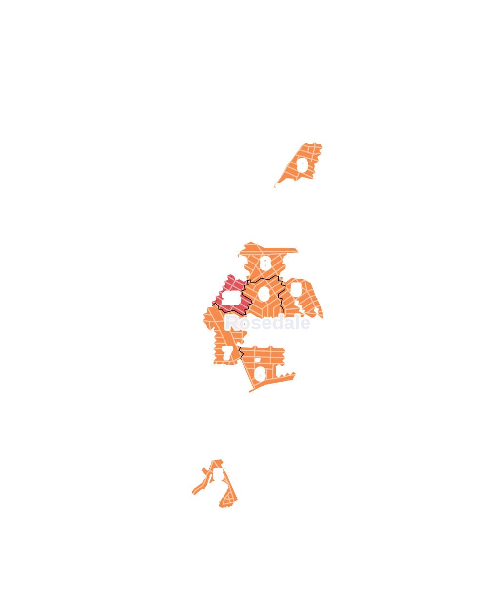
- 5 to 9
- 10 to 19
- 20 to 49
- 50 to 99
- 100 or more
- Not shaded: fewer than 5, held back under the rules in How complaints are counted, parks and public-housing grounds, and land in no patch
- Police precinct
- 116th
From January to June 2026 the NYPD recorded 74 major felonies at places in Rosedale, against 105 in the same months of 2025.
Sources: the NYPD's Complaint Data Historic, updated April 28, 2026, and Complaint Data Current (Year To Date), updated July 27, 2026, on NYC Open Data. Figures to June 30, 2026.
Street corners
- 1st Street & 2nd Street
- 1st Street & Meyer Avenue
- 2nd Street & 3rd Street
- 2nd Street & Meyer Avenue
- 130th Avenue & 243rd Street
- 130th Avenue & 244th Street
- 130th Avenue & Hook Creek Boulevard
- 130th Avenue & Laurelton Parkway
- 131st Avenue & 242nd Street
- 131st Avenue & 244th Street
- 131st Avenue & Hook Creek Boulevard
- 133rd Avenue & 243rd Street
- 133rd Avenue & Brookville Boulevard
- 133rd Avenue & Laurelton Parkway
- 134th Avenue & 245th Street
- 134th Avenue & 246th Street
- 135th Avenue & 241st Street
- 135th Avenue & 242nd Street
- 135th Avenue & 243rd Street
- 135th Avenue & 244th Street
- 135th Avenue & 245th Street
- 135th Avenue & 246th Street
- 135th Avenue & Belt Parkway
- 135th Avenue & Hook Creek Boulevard
- 137th Avenue & 241st Street
- 137th Avenue & 242nd Street
- 137th Avenue & 243rd Street
- 137th Avenue & 244th Street
- 137th Avenue & 246th Street
- 137th Avenue & Hook Creek Boulevard
- 139th Avenue & Caney Lane
- 144th Avenue & 253rd Street
- 144th Avenue & Memphis Avenue
- 145th Avenue & 253rd Street
- 145th Avenue & Frankton Street
- 145th Avenue & Hook Creek Boulevard
- 145th Avenue & Memphis Avenue
- 146th Avenue & Edgewood Avenue
- 147th Avenue & 240th Street
- 147th Avenue & 243rd Street
- 147th Avenue & 245th Street
- 147th Avenue & 253rd Place
- 147th Avenue & 253rd Street
- 147th Avenue & 253rd Street at Mayda Road
- 147th Avenue & 254th Street
- 147th Avenue & 256th Street
- 147th Avenue & 257th Street
- 147th Avenue & 258th Street
- 147th Avenue & 259th Street
- 147th Avenue & Edgewood Avenue
- 147th Avenue & Memphis Avenue
- 147th Avenue & Weller Lane
- 147th Drive & Edgewood Street
- 147th Drive & Huxley Street
- 147th Drive & Weller Lane
- 147th Road & Edgewood Street
- 147th Road & Huxley Street
- 147th Road & Weller Lane
- 148th Avenue & Edgewood Street
- 148th Avenue & Huxley Street
- 148th Avenue & Weller Lane
- 148th Drive & Edgewood Street
- 148th Drive & Huxley Street
- 148th Drive & Weller Lane
- 148th Road & Edgewood Street
- 148th Road & Huxley Street
- 148th Road & Weller Lane
- 149th Avenue & 242nd Street
- 149th Avenue & 243rd Street
- 149th Avenue & 253rd Street
- 149th Avenue & 257th Street
- 149th Avenue & 259th Street
- 149th Avenue & 262nd Street
- 149th Avenue & Edgewood Street
- 149th Avenue & Hook Creek Boulevard
- 149th Avenue & Huxley Street
- 149th Avenue & Weller Lane
- 149th Road & Huxley Street
- 149th Road & Weller Lane
- 240th Street & 147th Road
- 241st Street & 136th Avenue
- 241st Street & 138th Avenue
- 241st Street & 141st Avenue
- 241st Street & 142nd Avenue
- 241st Street & 143rd Avenue
- 241st Street & 144th Avenue
- 241st Street & 145th Avenue
- 241st Street & 147th Drive
- 241st Street & 148th Drive
- 241st Street & 148th Road
- 241st Street & Caney Road
- 241st Street & Huxley Street
- 241st Street & Mayda Road
- 241st Street & Memphis Avenue
- 241st Street & Newhall Avenue
- 241st Street & Weller Avenue
- 242nd Street & 131st Road
- 242nd Street & 132nd Avenue
- 242nd Street & 134th Avenue
- 242nd Street & 136th Avenue
- 242nd Street & 138th Avenue
- 243rd Street & 130th Road
- 243rd Street & 131st Avenue
- 243rd Street & 131st Road
- 243rd Street & 132nd Avenue
- 243rd Street & 132nd Road
- 243rd Street & 134th Avenue
- 243rd Street & 136th Avenue
- 243rd Street & 138th Avenue
- 243rd Street & 140th Avenue
- 243rd Street & 141st Avenue
- 243rd Street & 142nd Avenue
- 243rd Street & 143rd Avenue
- 243rd Street & 144th Avenue
- 243rd Street & 145th Avenue
- 243rd Street & Caney Road
- 243rd Street & Mayda Road
- 243rd Street & Memphis Avenue
- 243rd Street & Newhall Avenue
- 243rd Street & Weller Avenue
- 244th Street & 129th Road
- 244th Street & 130th Road
- 244th Street & 134th Avenue
- 244th Street & 136th Avenue
- 244th Street & 136th Road
- 244th Street & 137th Road
- 244th Street & 138th Avenue
- 245th Street & 133rd Drive
- 245th Street & 133rd Road
- 245th Street & 136th Avenue
- 245th Street & Newhall Avenue
- 246th Street & 135th Road
- 246th Street & 136th Avenue
- 246th Street & 137th Road
- 246th Street & 139th Avenue
- 246th Street & Memphis Avenue
- 247th Street & 139th Avenue
- 247th Street & 143rd Avenue
- 247th Street & Memphis Avenue
- 248th Street & 139th Avenue
- 248th Street & 143rd Avenue
- 248th Street & Hook Creek Boulevard
- 248th Street & Memphis Avenue
- 248th Street & Weller Avenue
- 249th Street & 139th Avenue
- 249th Street & 144th Avenue
- 249th Street & 145th Avenue
- 249th Street & 147th Avenue
- 249th Street & 147th Drive
- 249th Street & 147th Road
- 249th Street & 148th Avenue
- 249th Street & 148th Road
- 249th Street & Caney Road
- 249th Street & Hook Creek Boulevard
- 249th Street & Mayda Road
- 249th Street & Memphis Avenue
- 249th Street & Newhall Avenue
- 249th Street & Weller Avenue
- 250th Street & 139th Avenue
- 250th Street & Memphis Avenue
- 250th Street & Weller Avenue
- 253rd Street & 139th Avenue
- 253rd Street & 147th Drive
- 253rd Street & 147th Road
- 253rd Street & 148th Avenue
- 253rd Street & 148th Drive
- 253rd Street & 148th Road
- 253rd Street & 149th Drive
- 253rd Street & 149th Road
- 253rd Street & Huxley Street
- 253rd Street & Memphis Avenue
- 253rd Street & Weller Lane
- 254th Street & 139th Avenue
- 254th Street & 149th Drive
- 254th Street & Craft Avenue
- 254th Street & Memphis Avenue
- 255th Street & 149th Drive
- 255th Street & Craft Avenue
- 255th Street & Memphis Avenue
- 256th Street & 149th Road
- 256th Street & Craft Avenue
- 257th Street & 147th Drive
- 257th Street & 147th Road
- 257th Street & 148th Avenue
- 257th Street & 148th Drive
- 257th Street & 148th Road
- 257th Street & 149th Road
- 257th Street & Craft Avenue
- 258th Street & 147th Road
- 258th Street & 149th Road
- 258th Street & Craft Avenue
- 259th Street & 147th Drive
- 259th Street & 147th Road
- 259th Street & 148th Avenue
- 259th Street & 148th Drive
- 259th Street & 148th Road
- 259th Street & 149th Road
- 259th Street & Craft Avenue
- 262nd Place & Hungry Harbor Road
- 262nd Street & 149th Road
- Bayview Avenue & Broad Street
- Belt Parkway & 130th Avenue
- Belt Parkway & Francis Lewis Boulevard
- Belt Parkway & Merrick Boulevard
- Belt Parkway & North Conduit Avenue
- Brookville Boulevard & 128th Avenue
- Brookville Boulevard & 128th Road
- Brookville Boulevard & 129th Avenue
- Brookville Boulevard & 129th Road
- Brookville Boulevard & 130th Avenue
- Brookville Boulevard & 130th Road
- Brookville Boulevard & 131st Avenue
- Brookville Boulevard & 132nd Avenue
- Brookville Boulevard & 132nd Road
- Brookville Boulevard & 135th Avenue
- Brookville Boulevard & 136th Avenue
- Brookville Boulevard & 137th Avenue
- Brookville Boulevard & 137th Road
- Brookville Boulevard & 138th Avenue
- Brookville Boulevard & 142nd Avenue
- Brookville Boulevard & 144th Avenue
- Brookville Boulevard & 146th Avenue
- Brookville Boulevard & 147th Avenue
- Brookville Boulevard & 147th Road
- Brookville Boulevard & Belt Parkway
- Brookville Boulevard & Broad Street
- Brookville Boulevard & Caney Road
- Brookville Boulevard & Newhall Avenue
- Brookville Boulevard & Sunrise Highway
- Brookville Boulevard & Weller Avenue
- Caney Lane & Weller Avenue
- Francis Lewis Boulevard & 144th Avenue
- Francis Lewis Boulevard & 145th Avenue
- Francis Lewis Boulevard & 147th Avenue
- Francis Lewis Boulevard & 147th Drive
- Francis Lewis Boulevard & 147th Road
- Francis Lewis Boulevard & 241st Street
- Francis Lewis Boulevard & 243rd Street
- Francis Lewis Boulevard & 245th Street
- Francis Lewis Boulevard & 246th Street
- Francis Lewis Boulevard & 247th Street
- Francis Lewis Boulevard & 248th Street
- Francis Lewis Boulevard & 249th Street
- Francis Lewis Boulevard & 250th Street
- Francis Lewis Boulevard & 253rd Street
- Francis Lewis Boulevard & 254th Street
- Francis Lewis Boulevard & 255th Street
- Francis Lewis Boulevard & 256th Street
- Francis Lewis Boulevard & 257th Street
- Francis Lewis Boulevard & Brookville Boulevard
- Francis Lewis Boulevard & Caney Lane
- Francis Lewis Boulevard & Hook Creek Boulevard
- Francis Lewis Boulevard & Laurelton Parkway
- Francis Lewis Boulevard & North Conduit Avenue
- Francis Lewis Boulevard & South Conduit Avenue
- Francis Lewis Boulevard & Sunrise Highway
- Hook Creek Boulevard & 128th Avenue
- Hook Creek Boulevard & 128th Drive
- Hook Creek Boulevard & 128th Road
- Hook Creek Boulevard & 132nd Avenue
- Hook Creek Boulevard & 132nd Road
- Hook Creek Boulevard & 133rd Drive
- Hook Creek Boulevard & 133rd Road
- Hook Creek Boulevard & 134th Avenue
- Hook Creek Boulevard & 134th Road
- Hook Creek Boulevard & 135th Road
- Hook Creek Boulevard & 136th Avenue
- Hook Creek Boulevard & 136th Road
- Hook Creek Boulevard & 137th Road
- Hook Creek Boulevard & 139th Avenue
- Hook Creek Boulevard & 147th Drive
- Hook Creek Boulevard & 148th Drive
- Hook Creek Boulevard & 148th Road
- Hook Creek Boulevard & 149th Road
- Hook Creek Boulevard & 250th Street
- Hook Creek Boulevard & 253rd Street
- Hook Creek Boulevard & 255th Street
- Hook Creek Boulevard & 256th Street
- Hook Creek Boulevard & 257th Street
- Hook Creek Boulevard & Caney Lane
- Hook Creek Boulevard & Frankton Street
- Hook Creek Boulevard & Stephanie Drive
- Hook Creek Boulevard & Sunrise Highway
- Huxley Street & 149th Drive
- Huxley Street & Craft Avenue
- Huxley Street & Newhall Avenue
- Laurelton Parkway & Belt Parkway
- Laurelton Parkway & Mentone Avenue
- Memphis Avenue & Caney Lane
- Merrick Boulevard & 242nd Street
- Merrick Boulevard & 243rd Street
- Merrick Boulevard & 244th Street
- Merrick Boulevard & Brookville Boulevard
- Merrick Boulevard & Hook Creek Boulevard
- North Conduit Avenue & 242nd Street
- North Conduit Avenue & 243rd Street
- North Conduit Avenue & 244th Street
- North Conduit Avenue & 246th Street
- North Conduit Avenue & Brookville Boulevard
- North Conduit Avenue & Hook Creek Boulevard
- Rockaway Boulevard & 3rd Street
- Rockaway Boulevard & Brookville Boulevard
- Rockaway Boulevard & Meyer Avenue
- South Conduit Avenue & 139th Avenue
- South Conduit Avenue & 140th Avenue
- South Conduit Avenue & 241st Street
- South Conduit Avenue & 243rd Street
- South Conduit Avenue & 245th Street
- South Conduit Avenue & 246th Street
- South Conduit Avenue & 247th Street
- South Conduit Avenue & Hook Creek Boulevard
- South Conduit Avenue & Memphis Avenue
- Weller Lane & 149th Drive
- Weller Lane & Craft Avenue
How the figures above are measured: Methodology.