Laurelton
Neighborhood · Queens
Laurelton lies in Queens between Springfield Boulevard and the Laurelton Parkway, north of Conduit Avenue.
- 1.43 square miles
- 26,088 residents, 2020 Census
- 299 street corners
- 9 bus routes
Woods, ponds and farms covered the land when the colonies declared independence, and in the early 1900s developer Dean Alvord laid out a suburb modeled on an English village around a Long Island Rail Road station built in 1907 and named for the laurels that grew there. The neighborhood is known for its attached and detached Tudor-style houses and for streets divided by planted, tree-shaded center malls.
Sources: Laurelton, Queens (Wikipedia); Laurelton station (Wikipedia); Laurelton (Roberta Kossoff and Annette Henkin Landau, Arcadia Publishing, 2011) (Bookshare).
Laurelton borders six areas, and 137th Avenue holds more of its corners than any other street, 23 of 299.
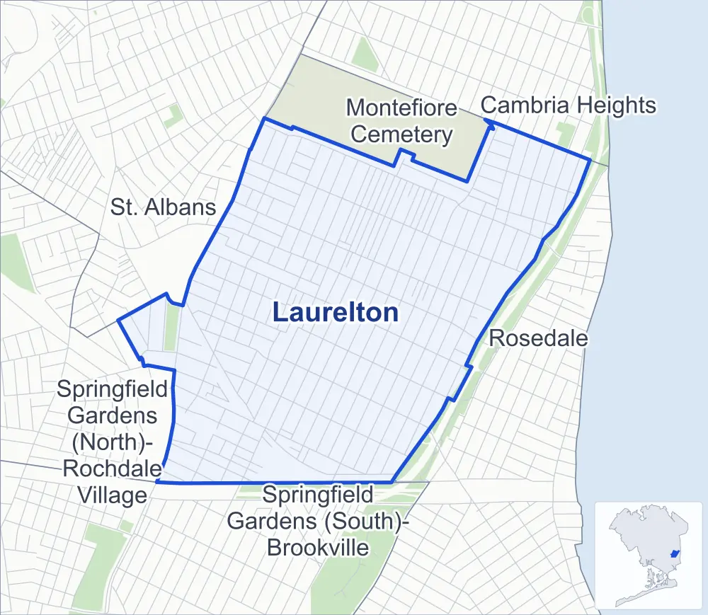
- Laurelton
- A neighboring area
- Park
Neighborhood areas and streets: NYC Department of City Planning. Parks: NYC Parks. Stations: MTA.
Neighboring areas
- Montefiore Cemetery north
- Cambria Heights northeast
- Rosedale east
- Springfield Gardens (South)-Brookville south
- Springfield Gardens (North)-Rochdale Village southwest
- St. Albans northwest
Getting around
Buses on nine routes stop in or at the edge of Laurelton.
- 7 local bus routes
- 2 express bus routes
Local bus routes
- Q5
- Q77
- Q84
- Q85
- Q86
- Q87
- Q89
Express bus routes
- QM63
- QM65
Safety record
Between 2021 and 2025, its corners averaged fewer police-reported crashes than the average Queens corner.
- 1,184 police-reported crashes at its corners
- 4.0 a corner, on average
- 5.2 the average Queens corner
- 66 corners with a clean record
Signal or safety changes on City record, at eight of its corners
- Leading pedestrian intervals
- 5
- Accessible pedestrian signals
- 2
- Turn calming
- 2
- Safety Improvement Projects
- 1
Camera tickets
In 2025 its corners had more school-zone speed camera tickets than red-light or bus-lane tickets.
- 0 red-light camera tickets
- 28,100 school-zone speed camera tickets at nine corners
- 0 bus-lane camera tickets
- Most speed tickets
- Francis Lewis Boulevard & 128th Avenue, 11,060
People and homes
The 2020 Census counted 26,088 residents in Laurelton, about 18,200 per square mile.
- 8,745 homes, 2020 Census
- 119 homes added since April 2010, net, by City Planning's count
Half of its 6,238 residential lots hold buildings from 1940 or earlier, and 48% of them date from before 1940, by the City's tax lot records.
NYCHA developments
NYCHA's FHA Repossessed Houses (Group VIII) and FHA Repossessed Houses (Group III) developments lie wholly or partly within Laurelton.
- FHA Repossessed Houses (Group VIII)
- Partly within Laurelton
- FHA Repossessed Houses (Group III)
- Partly within Laurelton
Parks
- Parkland
- 4.4 acres of Montbellier Park, as NYC Parks maps it within Laurelton
Streets and trees
- Trees
- 4,325 in NYC Parks' records, most often London planetree, Norway maple and pin oak
- Street with the most corners
- 137th Avenue, with 23 of the area's 299
- Height above sea level
- From 13 feet at 225th Street & 141st Road to 45 feet at 234th Street & 121st Avenue
- Honorary street names
- 5 at its corners, enacted by local law
Schools and libraries
The City lists seven schools and one library in Laurelton.
- Public schools
- 4
- Charter and private schools
- 3
- Library
- Laurelton Library
Public safety
How complaints are countedIn 2025 the NYPD recorded 208 major felonies at places in Laurelton.
Recorded by the NYPD at places in Laurelton
- 249 major felonies in 2024
- 1,152 other felonies, misdemeanors and violations in 2025
In 2025, on the streets along the edge of Laurelton, the NYPD recorded another 26 major felonies. Counting the streets along its edge, in 2025 the NYPD recorded 9.0 major felonies for every thousand residents the 2020 Census counted in Laurelton.
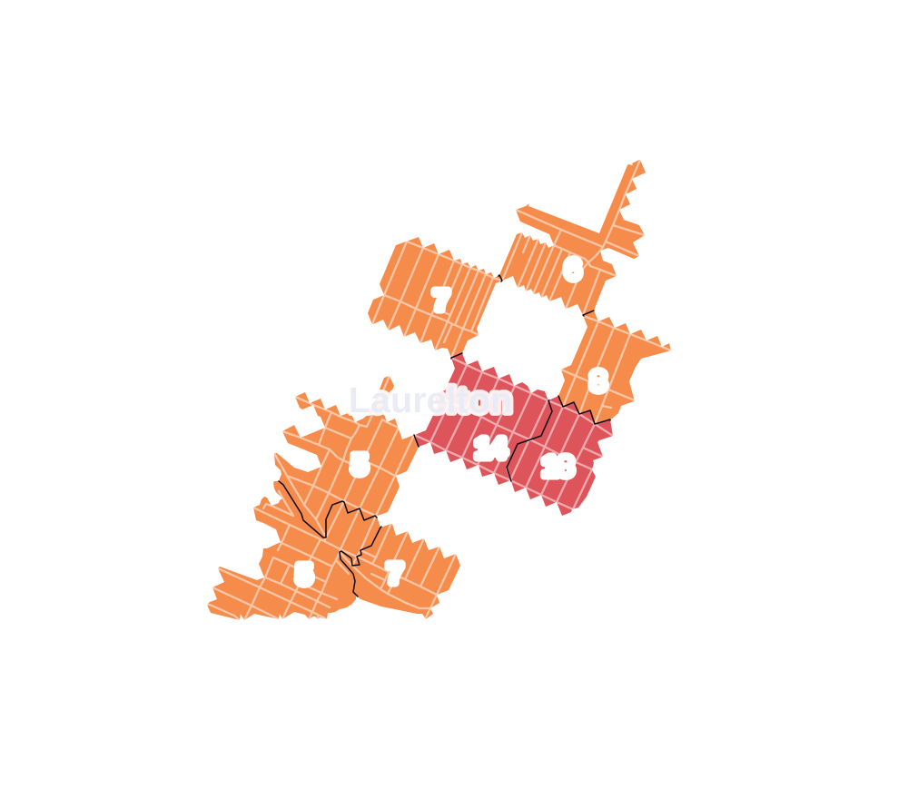
- 5 to 9
- 10 to 19
- 20 to 49
- 50 to 99
- 100 or more
- Not shaded: fewer than 5, held back under the rules in How complaints are counted, parks and public-housing grounds, and land in no patch
- Police precinct
- 116th
From January to June 2026 the NYPD recorded 101 major felonies at places in Laurelton, against 89 in the same months of 2025.
Sources: the NYPD's Complaint Data Historic, updated April 28, 2026, and Complaint Data Current (Year To Date), updated July 27, 2026, on NYC Open Data. Figures to June 30, 2026.
Street corners
- 121st Avenue & 237th Street
- 121st Avenue & Laurelton Parkway
- 129th Avenue & 235th Street
- 129th Avenue & 236th Street
- 129th Avenue & 237th Street
- 129th Avenue & Laurelton Parkway
- 130th Avenue & 233rd Street
- 130th Avenue & 234th Street
- 130th Avenue & 235th Street
- 130th Avenue & 236th Street
- 130th Avenue & 237th Street
- 131st Avenue & 235th Street
- 131st Avenue & 236th Street
- 131st Avenue & Laurelton Parkway
- 133rd Avenue & 218th Street
- 133rd Avenue & 219th Street
- 133rd Avenue & 224th Street
- 133rd Avenue & 225th Street
- 133rd Avenue & 226th Street
- 133rd Avenue & 227th Street
- 133rd Avenue & 228th Street
- 133rd Avenue & 229th Street
- 133rd Avenue & 230th Street
- 133rd Avenue & 231st Street
- 133rd Avenue & 232nd Street
- 133rd Avenue & 233rd Street
- 133rd Avenue & 234th Street
- 133rd Avenue & Dubons Lane
- 135th Avenue & 220th Place
- 135th Avenue & 224th Street
- 135th Avenue & 225th Street
- 135th Avenue & 226th Street
- 135th Avenue & 227th Street
- 135th Avenue & 228th Street
- 135th Avenue & 229th Street
- 135th Avenue & 230th Street
- 135th Avenue & 231st Street
- 135th Avenue & 232nd Street
- 135th Avenue & 233rd Street
- 135th Avenue & 234th Place
- 135th Avenue & 234th Street
- 136th Avenue & 220th Place
- 137th Avenue & 220th Place
- 137th Avenue & 233rd Street
- 137th Avenue & 234th Place
- 137th Avenue & 234th Street
- 137th Avenue & Belknap Street
- 137th Avenue & Southgate Street
- 137th Road & Carson Street
- 138th Avenue & 220th Place
- 138th Avenue & Carson Street
- 139th Avenue & 230th Place
- 139th Avenue & Belknap Street
- 139th Avenue & Carson Street
- 139th Avenue & Laurelton Parkway
- 139th Avenue & Sloan Street
- 140th Avenue & Marissa Street
- 140th Avenue & Ryan Road
- 141st Avenue & 230th Place
- 217th Street & 130th Avenue
- 217th Street & 131st Avenue
- 217th Street & 132nd Road
- 217th Street & 133rd Avenue
- 217th Street & 135th Avenue
- 217th Street & 136th Avenue
- 218th Street & 130th Avenue
- 218th Street & 131st Avenue
- 218th Street & 132nd Avenue
- 218th Street & 132nd Road
- 218th Street & 133rd Road
- 218th Street & 134th Road
- 218th Street & 135th Avenue
- 218th Street & 136th Avenue
- 218th Street & 136th Road
- 218th Street & 137th Avenue
- 218th Street & 137th Road
- 218th Street & 138th Avenue
- 219th Street & 130th Avenue
- 219th Street & 130th Drive
- 219th Street & 130th Road
- 219th Street & 131st Avenue
- 219th Street & 132nd Road
- 219th Street & 134th Road
- 219th Street & 135th Avenue
- 219th Street & 136th Avenue
- 219th Street & 137th Avenue
- 219th Street & 137th Road
- 219th Street & 138th Avenue
- 219th Street & 138th Road
- 219th Street & 139th Avenue
- 219th Street & 140th Avenue
- 219th Street & 141st Avenue
- 219th Street & 141st Road
- 219th Street & Carson Street
- 220th Place & 137th Road
- 220th Street & 130th Avenue
- 220th Street & 130th Drive
- 220th Street & 130th Road
- 220th Street & 131st Avenue
- 220th Street & 132nd Avenue
- 220th Street & 132nd Road
- 220th Street & 133rd Avenue
- 220th Street & 133rd Road
- 220th Street & 134th Road
- 220th Street & 135th Avenue
- 220th Street & 136th Avenue
- 220th Street & 137th Avenue
- 220th Street & 137th Road
- 220th Street & 138th Avenue
- 220th Street & Merrick Boulevard
- 221st Street & 130th Avenue
- 221st Street & 131st Avenue
- 221st Street & 133rd Avenue
- 221st Street & 134th Road
- 221st Street & 135th Avenue
- 221st Street & 136th Avenue
- 221st Street & 137th Avenue
- 221st Street & 142nd Road
- 221st Street & Edgewood Avenue
- 221st Street & Merrick Boulevard
- 222nd Street & 130th Avenue
- 222nd Street & 131st Avenue
- 222nd Street & 133rd Avenue
- 222nd Street & 134th Road
- 222nd Street & 135th Avenue
- 222nd Street & 136th Avenue
- 222nd Street & 137th Avenue
- 222nd Street & 138th Avenue
- 222nd Street & 138th Road
- 222nd Street & 139th Avenue
- 222nd Street & 141st Avenue
- 222nd Street & 141st Road
- 222nd Street & 142nd Road
- 222nd Street & 143rd Avenue
- 222nd Street & 143rd Road
- 222nd Street & Carson Street
- 223rd Street & 130th Avenue
- 223rd Street & 131st Avenue
- 223rd Street & 133rd Avenue
- 223rd Street & 134th Road
- 223rd Street & 135th Avenue
- 223rd Street & 137th Avenue
- 223rd Street & 137th Road
- 223rd Street & 138th Avenue
- 223rd Street & 139th Avenue
- 223rd Street & 142nd Road
- 223rd Street & Carson Street
- 223rd Street & Merrick Boulevard
- 223rd Street & Prospect Court
- 224th Street & 130th Avenue
- 224th Street & 131st Avenue
- 224th Street & 134th Road
- 224th Street & 137th Avenue
- 224th Street & 138th Avenue
- 224th Street & 139th Avenue
- 224th Street & 141st Avenue
- 224th Street & 141st Road
- 224th Street & 142nd Road
- 224th Street & 143rd Avenue
- 224th Street & Carson Street
- 224th Street & Edgewood Avenue
- 224th Street & Prospect Court
- 225th Street & 130th Avenue
- 225th Street & 131st Avenue
- 225th Street & 137th Avenue
- 225th Street & 138th Avenue
- 225th Street & 139th Avenue
- 225th Street & 141st Avenue
- 225th Street & 141st Road
- 225th Street & 142nd Road
- 225th Street & 143rd Avenue
- 225th Street & Edgewood Avenue
- 225th Street & Mentone Avenue
- 225th Street & Prospect Court
- 226th Street & 129th Avenue
- 226th Street & 130th Avenue
- 226th Street & 131st Avenue
- 226th Street & 137th Avenue
- 226th Street & 138th Avenue
- 226th Street & 139th Avenue
- 226th Street & 141st Avenue
- 226th Street & Mentone Avenue
- 227th Street & 130th Avenue
- 227th Street & 131st Avenue
- 227th Street & 137th Avenue
- 227th Street & 138th Avenue
- 227th Street & 139th Avenue
- 227th Street & 141st Avenue
- 228th Street & 130th Avenue
- 228th Street & 131st Avenue
- 228th Street & 137th Avenue
- 228th Street & 138th Avenue
- 228th Street & 139th Avenue
- 228th Street & 141st Avenue
- 228th Street & Mentone Avenue
- 229th Street & 129th Avenue
- 229th Street & 130th Avenue
- 229th Street & 131st Avenue
- 229th Street & 137th Avenue
- 229th Street & 138th Avenue
- 229th Street & 139th Avenue
- 229th Street & 141st Avenue
- 230th Place & Mentone Avenue
- 230th Street & 130th Avenue
- 230th Street & 131st Avenue
- 230th Street & 137th Avenue
- 230th Street & 138th Avenue
- 230th Street & 139th Avenue
- 230th Street & 141st Avenue
- 231st Street & 130th Avenue
- 231st Street & 131st Avenue
- 231st Street & 137th Avenue
- 231st Street & 139th Avenue
- 231st Street & 141st Avenue
- 232nd Street & 129th Avenue
- 232nd Street & 130th Avenue
- 232nd Street & 131st Avenue
- 232nd Street & 137th Avenue
- 232nd Street & 139th Avenue
- 232nd Street & 141st Avenue
- 233rd Street & 125th Avenue
- 233rd Street & 126th Avenue
- 233rd Street & 128th Avenue
- 233rd Street & 128th Drive
- 233rd Street & 128th Road
- 233rd Street & 129th Avenue
- 233rd Street & 131st Avenue
- 233rd Street & 139th Avenue
- 233rd Street & Mentone Avenue
- 234th Street & 121st Avenue
- 234th Street & 128th Avenue
- 234th Street & 129th Avenue
- 234th Street & 131st Avenue
- 234th Street & 133rd Road
- 234th Street & 134th Road
- 234th Street & 139th Avenue
- 235th Street & 128th Avenue
- 236th Street & 128th Avenue
- 237th Street & 128th Avenue
- 238th Street & 128th Avenue
- Alecia Avenue & Marissa Street
- Belknap Street & Bennett Street
- Francis Lewis Boulevard & 121st Avenue
- Francis Lewis Boulevard & 125th Avenue
- Francis Lewis Boulevard & 126th Avenue
- Francis Lewis Boulevard & 128th Avenue
- Francis Lewis Boulevard & 128th Drive
- Francis Lewis Boulevard & 128th Road
- Francis Lewis Boulevard & 129th Avenue
- Francis Lewis Boulevard & 130th Avenue
- Francis Lewis Boulevard & 131st Avenue
- Francis Lewis Boulevard & 133rd Avenue
- Francis Lewis Boulevard & 135th Avenue
- Francis Lewis Boulevard & 137th Avenue
- Francis Lewis Boulevard & 230th Place
- Francis Lewis Boulevard & 231st Street
- Francis Lewis Boulevard & 232nd Street
- Francis Lewis Boulevard & 233rd Street
- Francis Lewis Boulevard & 234th Street
- Francis Lewis Boulevard & Merrick Boulevard
- Laurelton Parkway & 128th Avenue
- Laurelton Parkway & 134th Road
- Laurelton Parkway & 238th Street
- Laurelton Parkway & Belt Parkway
- Laurelton Parkway & Belt Parkway (Exit 24A)
- Merrick Boulevard & 218th Street
- Merrick Boulevard & 219th Street
- Merrick Boulevard & 222nd Street
- Merrick Boulevard & 224th Street
- Merrick Boulevard & 225th Street
- Merrick Boulevard & 226th Street
- Merrick Boulevard & 227th Street
- Merrick Boulevard & 228th Street
- Merrick Boulevard & 229th Street
- Merrick Boulevard & 230th Street
- Merrick Boulevard & 231st Street
- Merrick Boulevard & 232nd Street
- Merrick Boulevard & 233rd Street
- Merrick Boulevard & 234th Street
- Merrick Boulevard & Laurelton Parkway
- North Conduit Avenue & 143rd Avenue
- North Conduit Avenue & 144th Avenue
- North Conduit Avenue & 222nd Street
- North Conduit Avenue & 225th Street
- North Conduit Avenue & Laurelton Parkway
- North Conduit Avenue & Sunrise Highway
- Southgate Street & Southgate Plaza
- Springfield Boulevard & 135th Avenue
- Springfield Boulevard & 136th Avenue
- Springfield Boulevard & 137th Avenue
- Springfield Boulevard & 138th Road
- Springfield Boulevard & 139th Avenue
- Springfield Boulevard & 140th Avenue
- Springfield Boulevard & 143rd Avenue
- Springfield Boulevard & 144th Avenue
- Springfield Boulevard & 193rd Street
- Springfield Boulevard & Eastgate Plaza
- Springfield Boulevard & Edgewood Avenue
- Springfield Boulevard & Merrick Boulevard
How the figures above are measured: Methodology.