St. Albans
Neighborhood · Queens
St. Albans spreads across southeast Queens around the meeting of Linden and Farmers Boulevards, about two miles north of Kennedy Airport.
- 2.66 square miles
- 51,816 residents, 2020 Census
- 579 street corners
- 17 bus routes
Long a district of farms and forest, it gained a Long Island Rail Road station in 1898, and around the turn of the 20th century a committee of local landowners named it for St Albans in Hertfordshire, England. Its Addisleigh Park section, a city historic district since 2011, holds about 422 buildings, largely houses in Tudor Revival, Colonial Revival and Arts and Crafts styles, and from the 1940s it became home to many celebrated African American entertainers and athletes.
Sources: Addisleigh Park Historic District Designation Report (LP-2405, February 1, 2011) (NYC Landmarks Preservation Commission); St. Albans, Queens (Wikipedia).
St. Albans borders nine areas, and Farmers Boulevard holds more of its corners than any other street, 51 of 579.
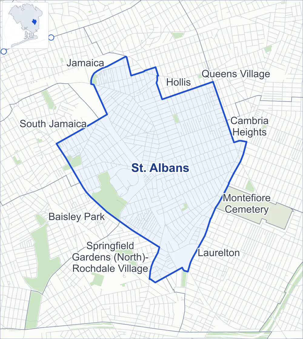
- St. Albans
- A neighboring area
- Park
- Another station
Neighborhood areas and streets: NYC Department of City Planning. Parks: NYC Parks. Stations: MTA.
Neighboring areas
- Hollis north
- Queens Village northeast
- Cambria Heights east
- Laurelton southeast
- Montefiore Cemetery southeast
- Springfield Gardens (North)-Rochdale Village south
- Baisley Park southwest
- South Jamaica west
- Jamaica northwest
Getting around
Buses on 17 routes stop in or at the edge of St. Albans.
- 14 local bus routes
- 3 express bus routes
Local bus routes
- Q2
- Q3
- Q4
- Q5
- Q27
- Q42
- Q51
- Q77
- Q83
- Q84
- Q85
- Q86
- Q87
- Q89
Express bus routes
- QM63
- QM64
- QM65
Safety record
Between 2021 and 2025, its corners averaged fewer police-reported crashes than the average Queens corner.
- 2,453 police-reported crashes at its corners
- 4.2 a corner, on average
- 5.2 the average Queens corner
- 118 corners with a clean record
Signal or safety changes on City record, at 36 of its corners
- Leading pedestrian intervals
- 29
- Accessible pedestrian signals
- 10
- Turn calming
- 4
Camera tickets
In 2025 its corners had more school-zone speed camera tickets than bus-lane or red-light tickets.
- 0 red-light camera tickets
- 15,915 school-zone speed camera tickets at 20 corners
- 6,324 bus-lane camera tickets at two corners
- Most speed tickets
- Springfield Boulevard & Lucas Street, 2,773
- Most bus-lane tickets
- Linden Boulevard & Merrick Boulevard, 3,781
People and homes
The 2020 Census counted 51,816 residents in St. Albans, about 19,500 per square mile.
- 16,719 homes, 2020 Census
- 366 homes added since April 2010, net, by City Planning's count
Half of its 11,610 residential lots hold buildings from 1935 or earlier, and 60% of them date from before 1940, by the City's tax lot records.
NYCHA developments
NYCHA's FHA Repossessed Houses (Group VI), FHA Repossessed Houses (Group VII), FHA Repossessed Houses (Group VIII), FHA Repossessed Houses (Group IV), FHA Repossessed Houses (Group V), FHA Repossessed Houses (Group I), FHA Repossessed Houses (Group X), FHA Repossessed Houses (Group II) and FHA Repossessed Houses (Group III) developments lie wholly or partly within St. Albans.
- FHA Repossessed Houses (Group VI)
- Partly within St. Albans
- FHA Repossessed Houses (Group VII)
- Partly within St. Albans
- FHA Repossessed Houses (Group VIII)
- Partly within St. Albans
- FHA Repossessed Houses (Group IV)
- Partly within St. Albans
- FHA Repossessed Houses (Group V)
- Partly within St. Albans
- FHA Repossessed Houses (Group I)
- Partly within St. Albans
- FHA Repossessed Houses (Group X)
- Partly within St. Albans
- FHA Repossessed Houses (Group II)
- Partly within St. Albans
- FHA Repossessed Houses (Group III)
- Partly within St. Albans
Parks and landmarks
- Parkland
- 73.1 acres of NYC Parks property
- The largest pieces
- Roy Wilkins Recreation Center (56.8 acres), Archie Spigner Park (8.6 acres) and Peters Field (2.9 acres)
- Historic district
- Addisleigh Park Historic District, wholly or partly within St. Albans
Streets and trees
- Trees
- 9,791 in NYC Parks' records, most often London planetree, pin oak and thornless honeylocust
- Street with the most corners
- Farmers Boulevard, with 51 of the area's 579
- Height above sea level
- From 19 feet at 136th Avenue & Westgate Street to 60 feet at Francis Lewis Boulevard & 114th Drive
- Honorary street names
- 17 at its corners, enacted by local law
Schools and libraries
The City lists 14 schools and one library in St. Albans.
- Public schools
- 8
- Charter and private schools
- 6
- Library
- St. Albans Library
Public safety
How complaints are countedIn 2025 the NYPD recorded 373 major felonies at places in St. Albans.
Recorded by the NYPD at places in St. Albans
- 356 major felonies in 2024
- 1,768 other felonies, misdemeanors and violations in 2025
In 2025, on the streets along the edge of St. Albans, the NYPD recorded another 101 major felonies. Counting the streets along its edge, in 2025 the NYPD recorded 9.1 major felonies for every thousand residents the 2020 Census counted in St. Albans.
- Police precincts
- 113th (most of the area), 116th, 103rd, 105th
From January to June 2026 the NYPD recorded 184 major felonies at places in St. Albans, against 174 in the same months of 2025.
Sources: the NYPD's Complaint Data Historic, updated April 28, 2026, and Complaint Data Current (Year To Date), updated July 27, 2026, on NYC Open Data. Figures to June 30, 2026.
Street corners
- 104th Avenue & 183rd Place
- 104th Avenue & 184th Street
- 104th Avenue & 185th Street
- 104th Avenue & 186th Street
- 104th Avenue & 187th Street
- 104th Avenue & Hollis Avenue
- 109th Avenue & 191st Street
- 109th Avenue & 192nd Street
- 109th Avenue & 193rd Street
- 109th Avenue & 194th Street
- 109th Avenue & 195th Street
- 109th Avenue & Farmers Boulevard
- 109th Road & 190th Place
- 110th Avenue & 178th Street
- 110th Avenue & 179th Street
- 110th Road & 190th Place
- 111th Avenue & 173rd Street
- 111th Avenue & 174th Street
- 111th Avenue & 175th Street
- 111th Avenue & 176th Street
- 111th Avenue & 177th Street
- 111th Avenue & 195th Street
- 111th Avenue & 205th Street
- 111th Avenue & Farmers Boulevard
- 111th Avenue & Sayres Avenue
- 112th Avenue & 178th Place
- 112th Avenue & 178th Street
- 112th Avenue & 179th Street
- 113th Avenue & Hannibal Street
- 113th Avenue & Marne Place
- 113th Avenue & Mayville Street
- 114th Drive & Mexico Street
- 114th Drive & Newburg Street
- 114th Drive & Ovid Place
- 114th Road & 178th Place
- 114th Road & Mexico Street
- 114th Road & Newburg Street
- 115th Avenue & 173rd Street
- 115th Avenue & 174th Street
- 115th Avenue & 175th Place
- 115th Avenue & 175th Street
- 115th Avenue & 176th Street
- 115th Avenue & 177th Place
- 115th Avenue & 177th Street
- 115th Avenue & 196th Street
- 115th Avenue & 197th Street
- 115th Avenue & 198th Street
- 115th Avenue & 199th Street
- 115th Avenue & 200th Street
- 115th Avenue & 203rd Street
- 115th Avenue & 204th Street
- 115th Avenue & 205th Street
- 115th Avenue & Farmers Boulevard
- 116th Avenue & 172nd Street
- 116th Avenue & 173rd Street
- 116th Avenue & 174th Street
- 116th Avenue & 191st Street
- 116th Avenue & 196th Street
- 116th Avenue & 197th Street
- 116th Avenue & 198th Street
- 116th Avenue & 199th Street
- 116th Avenue & 200th Street
- 116th Avenue & 201st Street
- 116th Avenue & 203rd Street
- 116th Avenue & 204th Street
- 116th Avenue & 205th Street
- 116th Avenue & Farmers Boulevard
- 118th Avenue & 201st Place
- 118th Avenue & Nashville Boulevard
- 118th Road & Riverton Street
- 119th Avenue & 190th Street
- 119th Avenue & 191st Street
- 119th Avenue & 198th Street
- 119th Avenue & 200th Street
- 119th Avenue & 201st Place
- 119th Avenue & 205th Street
- 119th Avenue & Nashville Boulevard
- 119th Road & 177th Place
- 119th Road & Montauk Street
- 119th Road & Riverton Street
- 120th Avenue & 177th Place
- 120th Avenue & 177th Street
- 120th Avenue & 178th Place
- 120th Avenue & 178th Street
- 120th Avenue & 179th Street
- 120th Avenue & 180th Street
- 120th Avenue & 189th Street
- 120th Avenue & 190th Street
- 120th Avenue & 191st Street
- 120th Avenue & 193rd Street
- 120th Avenue & 195th Street
- 120th Avenue & 196th Street
- 120th Avenue & 197th Street
- 120th Avenue & 198th Street
- 120th Avenue & 199th Street
- 120th Avenue & 200th Street
- 120th Avenue & 201st Place
- 120th Avenue & 203rd Street
- 120th Avenue & Baisley Boulevard
- 120th Avenue & Farmers Boulevard
- 120th Avenue & Irwin Place
- 120th Avenue & Lucas Street
- 120th Avenue & Nashville Boulevard
- 120th Avenue & Roe Road
- 120th Avenue & Sunbury Road
- 121st Avenue & Benton Street
- 121st Avenue & Grayson Street
- 121st Avenue & Lucas Street
- 121st Avenue & Milburn Street
- 121st Avenue & Nashville Boulevard
- 122nd Avenue & Benton Street
- 122nd Avenue & Grayson Street
- 122nd Avenue & Lucas Street
- 122nd Avenue & Milburn Street
- 122nd Avenue & Montauk Street
- 122nd Avenue & Nellis Street
- 134th Avenue & Belknap Street
- 134th Avenue & Crandall Avenue
- 134th Avenue & Thurston Street
- 135th Avenue & Belknap Street
- 135th Avenue & Cheney Street
- 135th Avenue & Denis Street
- 135th Avenue & Thurston Street
- 136th Avenue & Belknap Street
- 136th Avenue & Thurston Street
- 136th Avenue & Westgate Street
- 137th Avenue & Bennett Street
- 137th Avenue & Sloan Street
- 172nd Street & 111th Avenue
- 172nd Street & 111th Road
- 172nd Street & 115th Avenue
- 172nd Street & Sayres Avenue
- 173rd Street & 110th Avenue
- 173rd Street & Sayres Avenue
- 174th Street & Sayres Avenue
- 175th Street & 110th Avenue
- 175th Street & 113th Avenue
- 175th Street & Adelaide Road
- 175th Street & Murdock Avenue
- 175th Street & Sayres Avenue
- 176th Street & Sayres Avenue
- 177th Street & 112th Avenue
- 177th Street & Sayres Avenue
- 178th Place & 119th Road
- 178th Place & Leslie Road
- 178th Place & Sayres Avenue
- 178th Place & Selover Road
- 178th Street & 114th Road
- 178th Street & 119th Road
- 178th Street & Leslie Road
- 178th Street & Sayres Avenue
- 178th Street & Ursina Road
- 179th Street & 114th Road
- 179th Street & 119th Road
- 179th Street & Leslie Road
- 179th Street & Sayres Avenue
- 180th Street & 110th Avenue
- 180th Street & 112th Avenue
- 180th Street & 114th Road
- 180th Street & 119th Road
- 180th Street & 179th Place
- 180th Street & Anderson Road
- 180th Street & Eveleth Road
- 180th Street & Leslie Road
- 180th Street & Selover Road
- 180th Street & Zoller Road
- 183rd Place & Henderson Avenue
- 184th Street & Henderson Avenue
- 185th Street & Henderson Avenue
- 186th Street & Henderson Avenue
- 187th Street & Henderson Avenue
- 187th Street & Ludlum Avenue
- 188th Street & 104th Avenue
- 188th Street & Henderson Avenue
- 188th Street & Ludlum Avenue
- 189th Street & 104th Avenue
- 189th Street & 118th Avenue
- 189th Street & 119th Avenue
- 189th Street & 119th Road
- 189th Street & Brinkerhoff Avenue
- 189th Street & Henderson Avenue
- 189th Street & Ludlum Avenue
- 190th Street & 116th Road
- 190th Street & 117th Road
- 190th Street & 118th Avenue
- 190th Street & 118th Road
- 191st Street & 105th Avenue
- 191st Street & 109th Road
- 191st Street & 110th Road
- 191st Street & 115th Drive
- 191st Street & 116th Road
- 191st Street & 118th Road
- 191st Street & 122nd Avenue
- 191st Street & Nashville Boulevard
- 192nd Street & 104th Avenue
- 192nd Street & 105th Avenue
- 192nd Street & 109th Road
- 192nd Street & 110th Road
- 192nd Street & 116th Road
- 192nd Street & 117th Road
- 192nd Street & 118th Avenue
- 192nd Street & 118th Road
- 192nd Street & 119th Avenue
- 192nd Street & 120th Avenue
- 192nd Street & 121st Avenue
- 192nd Street & 122nd Avenue
- 192nd Street & Nashville Boulevard
- 193rd Street & 105th Avenue
- 193rd Street & 109th Road
- 193rd Street & 116th Road
- 193rd Street & 117th Road
- 193rd Street & 118th Avenue
- 193rd Street & 119th Avenue
- 193rd Street & 122nd Avenue
- 193rd Street & Nashville Boulevard
- 193rd Street & Pineville Lane
- 193rd Street & Williamson Avenue
- 194th Street & 104th Avenue
- 194th Street & 109th Road
- 194th Street & 110th Avenue
- 194th Street & 110th Road
- 194th Street & 111th Avenue
- 194th Street & 111th Road
- 194th Street & 112th Avenue
- 194th Street & 112th Road
- 194th Street & 113th Avenue
- 194th Street & 113th Road
- 194th Street & 114th Drive
- 194th Street & 114th Road
- 194th Street & 115th Avenue
- 194th Street & 115th Drive
- 194th Street & 115th Road
- 194th Street & 116th Avenue
- 194th Street & 116th Road
- 194th Street & 117th Road
- 194th Street & 118th Avenue
- 194th Street & 119th Avenue
- 194th Street & 120th Avenue
- 194th Street & 122nd Avenue
- 194th Street & Hollis Avenue
- 194th Street & Murdock Avenue
- 194th Street & Nashville Boulevard
- 195th Street & 109th Road
- 195th Street & 110th Road
- 195th Street & 116th Road
- 195th Street & 117th Road
- 195th Street & 118th Avenue
- 195th Street & 119th Avenue
- 195th Street & 122nd Avenue
- 195th Street & Hollis Avenue
- 196th Street & 111th Road
- 196th Street & 112th Avenue
- 196th Street & 112th Road
- 196th Street & 113th Avenue
- 196th Street & 113th Road
- 196th Street & 114th Drive
- 196th Street & 114th Road
- 196th Street & 115th Drive
- 196th Street & 115th Road
- 196th Street & 116th Road
- 196th Street & 118th Avenue
- 196th Street & 119th Avenue
- 196th Street & 122nd Avenue
- 196th Street & Murdock Avenue
- 197th Street & 112th Avenue
- 197th Street & 113th Avenue
- 197th Street & 118th Avenue
- 197th Street & 119th Avenue
- 197th Street & 122nd Avenue
- 197th Street & Murdock Avenue
- 197th Street & Nashville Boulevard
- 197th Street & Williamson Avenue
- 198th Street & 112th Avenue
- 198th Street & 113th Avenue
- 198th Street & 118th Avenue
- 198th Street & 122nd Avenue
- 199th Street & 112th Avenue
- 199th Street & 113th Avenue
- 199th Street & 118th Avenue
- 199th Street & 119th Avenue
- 199th Street & Nashville Boulevard
- 200th Street & 112th Avenue
- 200th Street & 113th Avenue
- 200th Street & 118th Avenue
- 200th Street & Nashville Boulevard
- 201st Street & 112th Avenue
- 201st Street & 113th Avenue
- 201st Street & 115th Avenue
- 201st Street & 118th Avenue
- 201st Street & 119th Avenue
- 201st Street & 120th Avenue
- 201st Street & Murdock Avenue
- 201st Street & Nashville Boulevard
- 202nd Street & 112th Avenue
- 202nd Street & 113th Avenue
- 202nd Street & 115th Avenue
- 202nd Street & 116th Avenue
- 202nd Street & 118th Avenue
- 202nd Street & 119th Avenue
- 202nd Street & 120th Avenue
- 202nd Street & Murdock Avenue
- 203rd Street & 112th Avenue
- 203rd Street & 113th Avenue
- 203rd Street & 118th Avenue
- 203rd Street & 119th Avenue
- 203rd Street & Murdock Avenue
- 204th Street & 112th Avenue
- 204th Street & 113th Avenue
- 204th Street & 118th Avenue
- 204th Street & 119th Avenue
- 204th Street & Murdock Avenue
- 204th Street & Nashville Boulevard
- 205th Street & 111th Road
- 205th Street & 112th Avenue
- 205th Street & 112th Road
- 205th Street & 113th Avenue
- 205th Street & 113th Road
- 205th Street & 114th Drive
- 205th Street & 114th Road
- 205th Street & 115th Drive
- 205th Street & 115th Road
- 205th Street & 116th Road
- 205th Street & 118th Avenue
- Anderson Road & Sidway Place
- Baisley Boulevard & 119th Road
- Baisley Boulevard & 178th Place
- Baisley Boulevard & 179th Street
- Baisley Boulevard & 180th Street
- Baisley Boulevard & Everitt Place
- Baisley Boulevard & Lovingham Place
- Baisley Boulevard & Montauk Street
- Baisley Boulevard & Riverton Street
- Belknap Street & Mathewson Court
- Brinkerhoff Avenue & Firwood Place
- Brinkerhoff Avenue & Rye Place
- Cheney Street & Crandall Avenue
- Denis Street & Crandall Avenue
- Dormans Road & Ovid Place
- Dunkirk Street & Babylon Avenue
- Dunkirk Street & Brinkerhoff Avenue
- Dunkirk Street & Elmira Avenue
- Dunkirk Street & Fonda Avenue
- Dunkirk Street & Galway Avenue
- Dunkirk Street & Hilburn Avenue
- Dunkirk Street & Ilion Avenue
- Dunkirk Street & Jordan Avenue
- Dunkirk Street & Newburg Street
- Dunkirk Street & Quencer Road
- Dunkirk Street & Rome Drive
- Dunkirk Street & Sullivan Road
- Dunkirk Street & Tioga Drive
- Dunkirk Street & Wood Street
- Eveleth Road & Mars Place
- Farmers Boulevard & 102nd Avenue
- Farmers Boulevard & 103rd Avenue
- Farmers Boulevard & 104th Avenue
- Farmers Boulevard & 105th Avenue
- Farmers Boulevard & 110th Road
- Farmers Boulevard & 111th Road
- Farmers Boulevard & 112th Avenue
- Farmers Boulevard & 112th Road
- Farmers Boulevard & 113th Avenue
- Farmers Boulevard & 113th Road
- Farmers Boulevard & 114th Drive
- Farmers Boulevard & 114th Road
- Farmers Boulevard & 115th Drive
- Farmers Boulevard & 115th Road
- Farmers Boulevard & 116th Road
- Farmers Boulevard & 118th Avenue
- Farmers Boulevard & 118th Road
- Farmers Boulevard & 119th Avenue
- Farmers Boulevard & 119th Drive
- Farmers Boulevard & 119th Road
- Farmers Boulevard & 120th Road
- Farmers Boulevard & 121st Avenue
- Farmers Boulevard & 122nd Avenue
- Farmers Boulevard & 134th Avenue
- Farmers Boulevard & Baisley Boulevard
- Farmers Boulevard & Hannibal Street
- Farmers Boulevard & Henderson Avenue
- Farmers Boulevard & Ilion Avenue
- Farmers Boulevard & Jordan Avenue
- Farmers Boulevard & Keeseville Avenue
- Farmers Boulevard & Lewiston Avenue
- Farmers Boulevard & Ludlum Avenue
- Farmers Boulevard & Mangin Avenue
- Farmers Boulevard & Mars Place
- Farmers Boulevard & Mathewson Court
- Farmers Boulevard & Montauk Street
- Farmers Boulevard & Murdock Avenue
- Farmers Boulevard & Sidway Place
- Farmers Boulevard & Suffolk Drive
- Farmers Boulevard & Tioga Drive
- Farmers Boulevard & Turin Drive
- Farmers Boulevard & Westgate Street
- Foch Boulevard & Everitt Place
- Foch Boulevard & Lovingham Place
- Francis Lewis Boulevard & 112th Road
- Francis Lewis Boulevard & 114th Drive
- Francis Lewis Boulevard & 115th Avenue
- Francis Lewis Boulevard & 115th Drive
- Francis Lewis Boulevard & 118th Avenue
- Francis Lewis Boulevard & Linden Boulevard
- Francis Lewis Boulevard & Springfield Boulevard
- Galway Avenue & Rye Place
- Grayson Street & Pineville Lane
- Grayson Street & Ridgedale Street
- Hannibal Street & Brinkerhoff Avenue
- Hannibal Street & Elmira Avenue
- Hannibal Street & Fonda Avenue
- Hannibal Street & Galway Avenue
- Hannibal Street & Hilburn Avenue
- Hannibal Street & Ilion Avenue
- Hannibal Street & Jordan Avenue
- Hannibal Street & Keeseville Avenue
- Hannibal Street & Lewiston Avenue
- Hannibal Street & Mangin Avenue
- Hilburn Avenue & Firwood Place
- Hilburn Avenue & Rye Place
- Hilburn Avenue & Wood Street
- Ilion Avenue & Wood Street
- Irwin Place & Roe Road
- Irwin Place & Sunbury Road
- Irwin Place & Troutville Road
- Irwin Place & Ursina Road
- Jordan Avenue & Wood Street
- Leslie Road & Irwin Place
- Liberty Avenue & 104th Avenue
- Liberty Avenue & 184th Street
- Liberty Avenue & 185th Street
- Liberty Avenue & 186th Street
- Liberty Avenue & 187th Street
- Liberty Avenue & 188th Street
- Liberty Avenue & Arcade Avenue
- Liberty Avenue & Babylon Avenue
- Liberty Avenue & Brinkerhoff Avenue
- Liberty Avenue & Dunkirk Street
- Liberty Avenue & Dunlop Avenue
- Liberty Avenue & Elmira Avenue
- Liberty Avenue & Farmers Boulevard at 109th Road
- Liberty Avenue & Farmers Boulevard at Hilburn Avenue
- Linden Boulevard & 114th Road
- Linden Boulevard & 115th Avenue
- Linden Boulevard & 172nd Street
- Linden Boulevard & 173rd Street
- Linden Boulevard & 174th Street
- Linden Boulevard & 175th Place
- Linden Boulevard & 175th Street
- Linden Boulevard & 176th Street
- Linden Boulevard & 177th Street
- Linden Boulevard & 178th Place
- Linden Boulevard & 178th Street
- Linden Boulevard & 179th Street
- Linden Boulevard & 180th Street
- Linden Boulevard & 190th Street
- Linden Boulevard & 191st Street
- Linden Boulevard & 192nd Street
- Linden Boulevard & 193rd Street
- Linden Boulevard & 194th Street
- Linden Boulevard & 195th Street
- Linden Boulevard & 196th Street
- Linden Boulevard & 197th Street
- Linden Boulevard & 198th Street
- Linden Boulevard & 199th Street
- Linden Boulevard & 200th Street
- Linden Boulevard & 201st Place
- Linden Boulevard & 201st Street
- Linden Boulevard & 202nd Street
- Linden Boulevard & 203rd Street
- Linden Boulevard & 204th Street
- Linden Boulevard & 205th Street
- Linden Boulevard & 207th Street
- Linden Boulevard & Everitt Place
- Linden Boulevard & Farmers Boulevard
- Linden Boulevard & Merrick Boulevard
- Linden Boulevard & Mexico Street
- Linden Boulevard & Murdock Avenue
- Linden Boulevard & Newburg Street
- Lucas Street & 120th Road
- Lucas Street & Pineville Lane
- Lucas Street & Ridgedale Street
- Mangin Avenue & Wood Street
- Marne Place & Adelaide Road
- Mayville Street & Brinkerhoff Avenue
- Mayville Street & Fonda Avenue
- Mayville Street & Galway Avenue
- Mayville Street & Hilburn Avenue
- Mayville Street & Ilion Avenue
- Mayville Street & Jordan Avenue
- Mayville Street & Keeseville Avenue
- Mayville Street & Lewiston Avenue
- Mayville Street & Mangin Avenue
- Merrick Boulevard & 111th Avenue
- Merrick Boulevard & 116th Avenue
- Merrick Boulevard & 118th Road
- Merrick Boulevard & 119th Avenue
- Merrick Boulevard & 125th Avenue
- Merrick Boulevard & 129th Avenue
- Merrick Boulevard & 130th Avenue
- Merrick Boulevard & 180th Street
- Merrick Boulevard & Anderson Road
- Merrick Boulevard & Baisley Boulevard
- Merrick Boulevard & Belknap Street
- Merrick Boulevard & Eveleth Road
- Merrick Boulevard & Farmers Boulevard
- Merrick Boulevard & Montauk Street
- Merrick Boulevard & Pineville Lane
- Merrick Boulevard & Ridgedale Street
- Merrick Boulevard & Zoller Road
- Mexico Street & Dormans Road
- Mexico Street & Dunkirk Drive
- Mexico Street & Quencer Road
- Mexico Street & Suffolk Drive
- Mexico Street & Tioga Drive
- Mexico Street & Turin Drive
- Montauk Street & 118th Road
- Montauk Street & Nellis Street
- Montauk Street & Williamson Avenue
- Murdock Avenue & 113th Avenue
- Murdock Avenue & 113th Road
- Murdock Avenue & 114th Drive
- Murdock Avenue & 114th Road
- Murdock Avenue & 175th Place
- Murdock Avenue & 176th Street
- Murdock Avenue & 177th Street
- Murdock Avenue & 178th Place
- Murdock Avenue & 178th Street
- Murdock Avenue & 179th Street
- Murdock Avenue & 180th Street
- Murdock Avenue & 198th Street
- Murdock Avenue & 199th Street
- Murdock Avenue & 200th Street
- Murdock Avenue & 205th Street
- Murdock Avenue & Dormans Road
- Murdock Avenue & Dunkirk Street
- Murdock Avenue & Keeseville Avenue
- Murdock Avenue & Lewiston Avenue
- Murdock Avenue & Mangin Avenue
- Murdock Avenue & Marne Place
- Murdock Avenue & Mayville Street
- Murdock Avenue & Mexico Street
- Murdock Avenue & Newburg Street
- Nashville Boulevard & Benton Street
- Nashville Boulevard & Grayson Street
- Nashville Boulevard & Lucas Street
- Nashville Boulevard & Milburn Street
- Nashville Boulevard & Montauk Street
- Nashville Boulevard & Nellis Street
- Newburg Street & Dormans Road
- Newburg Street & Quencer Road
- Newburg Street & Suffolk Drive
- Newburg Street & Tioga Drive
- Newburg Street & Turin Drive
- Pineville Lane & Adair Street
- Pineville Lane & Defoe Street
- Pineville Lane & Nepton Street
- Quencer Road & Ovid Place
- Quencer Road & Rome Drive
- Quencer Road & Sullivan Road
- Ridgedale Street & Defoe Street
- Ridgedale Street & Nepton Street
- Sayres Avenue & 175th Place
- Sayres Avenue & 179th Place
- Selover Road & Sidway Place
- Sidway Place & Eveleth Road
- Springfield Boulevard & 121st Avenue
- Springfield Boulevard & 122nd Avenue
- Springfield Boulevard & 131st Avenue
- Springfield Boulevard & 197th Street
- Springfield Boulevard & Carson Street
- Springfield Boulevard & Lucas Street
- Williamson Avenue & Benton Street
- Williamson Avenue & Grayson Street
- Williamson Avenue & Lucas Street
- Williamson Avenue & Milburn Street
- Williamson Avenue & Nellis Street
- Wood Street & Galway Avenue
- Wood Street & Keeseville Avenue
- Zoller Road & Sidway Place
How the figures above are measured: Methodology.