Jamaica
Neighborhood · Queens
Jamaica, among the oldest settlements in New York City, has long been a commercial and civic center of Queens, built around Jamaica Avenue and Jamaica station, a rail hub linked by AirTrain to Kennedy Airport.
- 1.68 square miles
- 60,993 residents, 2020 Census
- 350 street corners
- 7 subway stations
- 43 bus routes
The town was chartered under Dutch rule in 1656 and, after the English takeover of 1664, renamed for the Jameco, its original Native inhabitants; it became the seat of Queens County in 1683 and gained rail service to Brooklyn in 1836. Office buildings rose in the 1920s, and by the mid-1930s at least eight movie theaters stood on or near Jamaica Avenue. King Manor, once home to a Constitution signer, is now a museum.
Sources: La Casina Designation Report (LP-1940, January 30, 1996) (NYC Landmarks Preservation Commission); Jamaica, Queens (Wikipedia); Welcome to King Manor (King Manor Museum).
Jamaica borders seven areas, and Jamaica Avenue holds more of its corners than any other street, 47 of 350.
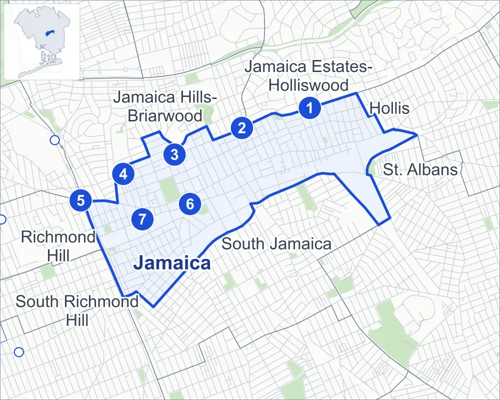
- Jamaica
- A neighboring area
- Park
- A station in the list
- Another station
Neighborhood areas and streets: NYC Department of City Planning. Parks: NYC Parks. Stations: MTA.
Neighboring areas
- Jamaica Estates-Holliswood northeast
- Hollis northeast
- St. Albans east
- South Jamaica southeast
- South Richmond Hill southwest
- Richmond Hill west
- Jamaica Hills-Briarwood northwest
Subway stations
- Jamaica-179 St lines F accessible
- 169 St lines F
- Parsons Blvd lines F
- Sutphin Blvd lines F
- Jamaica-Van Wyck lines E accessible
- Jamaica Center-Parsons/Archer lines E J Z accessible
- Sutphin Blvd-Archer Av-JFK Airport lines E J Z accessible
Getting around
Seven subway stations and buses on 43 routes stop in or at the edge of Jamaica.
- 7 subway stations
- 4 of them listed by the MTA as fully accessible
- 41 local bus routes
- 2 express bus routes
Local bus routes
- Q1
- Q2
- Q3
- Q4
- Q5
- Q6
- Q8
- Q9
- Q17
- Q20
- Q24
- Q25
- Q30
- Q31
- Q36
- Q40
- Q41
- Q42
- Q43
- Q44-SBS
- Q54
- Q56
- Q60
- Q65
- Q75
- Q76
- Q77
- Q82
- Q83
- Q84
- Q85
- Q86
- Q87
- Q89
- Q110
- Q111
- Q112
- Q113
- Q114
- Q115
- T300
Express bus routes
- QM64
- QM68
Safety record
Between 2021 and 2025, its corners averaged more police-reported crashes than the average Queens corner.
- 3,562 police-reported crashes at its corners
- 10.2 a corner, on average
- 5.2 the average Queens corner
- 21 corners with a clean record
Signal or safety changes on City record, at 95 of its corners
- Leading pedestrian intervals
- 63
- Accessible pedestrian signals
- 43
- Turn calming
- 35
- Barnes Dance all-way crossings
- 6
- Safety Improvement Projects
- 4
- Enhanced crossings
- 1
Camera tickets
In 2025 its corners had more bus-lane camera tickets than school-zone speed or red-light tickets.
- 126 red-light camera tickets at two corners
- 13,537 school-zone speed camera tickets at 15 corners
- 214,688 bus-lane camera tickets at eight corners
- Most red-light tickets
- Liberty Avenue & Sutphin Boulevard, 77
- Most speed tickets
- Jamaica Avenue & 179th Place, 3,625
- Most bus-lane tickets
- Jamaica Avenue & 149th Street, 91,989
People and homes
The 2020 Census counted 60,993 residents in Jamaica, about 36,300 per square mile.
- 20,038 homes, 2020 Census
- 8,625 homes added since April 2010, net, by City Planning's count
Half of its 4,150 residential lots hold buildings from 1920 or earlier, and 83% of them date from before 1940, by the City's tax lot records.
NYCHA developments
NYCHA's Conlon Lihfe Tower, International Tower and Shelton House developments lie wholly or partly within Jamaica.
Parks and landmarks
- Parkland
- 15.4 acres of NYC Parks property
- The largest pieces
- Rufus King Park (11.4 acres), Howard Von Dohlen Playground (1.4 acres) and Gateway Park (0.9 acre)
- Designated landmarks
- The Jamaica Savings Bank, the La Casina, the Jamaica High School and the Queens General Court House, among others
Streets and trees
- Trees
- 4,728 in NYC Parks' records, most often thornless honeylocust, London planetree and Callery pear
- Street with the most corners
- Jamaica Avenue, with 47 of the area's 350
- Height above sea level
- From 27 feet at 153rd Street & Tuskegee Airmen Way to 139 feet at 85th Drive & 151st Street
- Honorary street names
- 19 at its corners, enacted by local law
Schools and libraries
The City lists 16 schools and one library in Jamaica.
- Public schools
- 11
- Charter and private schools
- 5
- Library
- Central Library
Public art
The City's public art inventory lists three works in Jamaica: Soldiers and Sailors Monument (1896), Wingdale (1973) and The Wheel of Justice (2002).
- 3 works of public art
Public safety
How complaints are countedIn 2025 the NYPD recorded 1,271 major felonies at places in Jamaica.
Recorded by the NYPD at places in Jamaica
- 1,307 major felonies in 2024
- 5,783 other felonies, misdemeanors and violations in 2025
In 2025, on the streets along the edge of Jamaica, the NYPD recorded another 152 major felonies. Counting the streets along its edge, in 2025 the NYPD recorded 23.3 major felonies for every thousand residents the 2020 Census counted in Jamaica.
- Police precincts
- 103rd (most of the area), 107th
From January to June 2026 the NYPD recorded 627 major felonies at places in Jamaica, against 575 in the same months of 2025.
Sources: the NYPD's Complaint Data Historic, updated April 28, 2026, and Complaint Data Current (Year To Date), updated July 27, 2026, on NYC Open Data. Figures to June 30, 2026.
Street corners
- 85th Drive & 151st Street
- 88th Avenue & 145th Street
- 88th Avenue & 146th Street
- 88th Avenue & 153rd Street
- 88th Avenue & 168th Place
- 88th Avenue & 171st Street
- 88th Avenue & 175th Street
- 88th Avenue & 178th Street
- 88th Avenue & Sutphin Boulevard
- 89th Avenue & 144th Street
- 89th Avenue & 145th Street
- 89th Avenue & 146th Street
- 89th Avenue & 148th Street
- 89th Avenue & 153rd Street
- 89th Avenue & 161st Street
- 89th Avenue & 162nd Street
- 89th Avenue & 163rd Street
- 89th Avenue & 164th Street
- 89th Avenue & 165th Street
- 89th Avenue & 168th Place
- 89th Avenue & 168th Street
- 89th Avenue & 169th Street
- 89th Avenue & 170th Street
- 89th Avenue & 171st Street
- 89th Avenue & 172nd Street
- 89th Avenue & 173rd Street
- 89th Avenue & 175th Street
- 89th Avenue & 178th Street
- 89th Avenue & 181st Street
- 89th Avenue & 182nd Place
- 89th Avenue & 182nd Street
- 89th Avenue & 183rd Street
- 89th Avenue & 184th Place
- 89th Avenue & 184th Street
- 89th Avenue & Burdette Place
- 89th Avenue & Merrick Boulevard
- 89th Avenue & Sutphin Boulevard
- 90th Avenue & 138th Place
- 90th Avenue & 138th Street
- 90th Avenue & 139th Street
- 90th Avenue & 143rd Street
- 90th Avenue & 148th Street
- 90th Avenue & 149th Street
- 90th Avenue & 153rd Street
- 90th Avenue & 161st Street
- 90th Avenue & 168th Place
- 90th Avenue & 169th Street
- 90th Avenue & 170th Street
- 90th Avenue & 171st Street
- 90th Avenue & 172nd Street
- 90th Avenue & 175th Street
- 90th Avenue & 176th Street
- 90th Avenue & 178th Street
- 90th Avenue & 179th Place
- 90th Avenue & 179th Street
- 90th Avenue & 180th Street
- 90th Avenue & 181st Street
- 90th Avenue & 182nd Place
- 90th Avenue & 182nd Street
- 90th Avenue & 183rd Street
- 90th Avenue & 184th Place
- 90th Avenue & 184th Street
- 90th Avenue & 185th Street
- 90th Avenue & Grace Court
- 90th Avenue & Merrick Boulevard
- 90th Avenue & Sutphin Boulevard
- 90th Road & Grace Court
- 91st Avenue & 138th Place
- 91st Avenue & 138th Street
- 91st Avenue & 139th Street
- 91st Avenue & 143rd Street
- 91st Avenue & 144th Place
- 91st Avenue & 146th Street
- 91st Avenue & 172nd Street
- 91st Avenue & 173rd Street
- 91st Avenue & 175th Street
- 91st Avenue & 181st Street
- 91st Avenue & 182nd Place
- 91st Avenue & 182nd Street
- 91st Avenue & 183rd Street
- 91st Avenue & 184th Street
- 91st Avenue & Merrick Boulevard
- 91st Avenue & Sutphin Boulevard
- 93rd Avenue & 168th Place
- 93rd Avenue & 173rd Street
- 93rd Avenue & 175th Street
- 93rd Avenue & 176th Street
- 93rd Avenue & 177th Street
- 93rd Avenue & 178th Place
- 93rd Avenue & 178th Street
- 93rd Avenue & 179th Place
- 93rd Avenue & 180th Street
- 93rd Avenue & 181st Street
- 93rd Avenue & 182nd Place
- 93rd Avenue & Atari Lane
- 93rd Avenue & Nat Court
- 93rd Avenue & Park Circle
- 94th Avenue & 138th Place
- 94th Avenue & Liverpool Street
- 95th Avenue & 94th Avenue
- 95th Avenue & 138th Place
- 95th Avenue & 143rd Street
- 95th Avenue & 147th Place
- 95th Avenue & Allendale Street
- 95th Avenue & Brisbin Street
- 95th Avenue & Cresskill Place
- 95th Avenue & Liverpool Street
- 95th Avenue & Remington Street
- 95th Avenue & Sutphin Boulevard
- 95th Avenue & Waltham Street
- 97th Avenue & 147th Place
- 97th Avenue & Allendale Street
- 97th Avenue & Brisbin Street
- 97th Avenue & Cresskill Place
- 97th Avenue & Liverpool Street
- 97th Avenue & Remington Street
- 97th Avenue & Sanders Place
- 97th Avenue & Sutphin Boulevard
- 97th Avenue & Waltham Street
- 101st Avenue & Allendale Street
- 101st Avenue & Brisbin Street
- 101st Avenue & Cresskill Place
- 101st Avenue & Liverpool Street
- 101st Avenue & Remington Street
- 101st Avenue & Sanders Place
- 101st Avenue & Waltham Street
- 102nd Avenue & Allendale Street
- 102nd Avenue & Brisbin Street
- 102nd Avenue & Remington Street
- 105th Avenue & Liverpool Street
- 105th Avenue & Princeton Street
- 105th Avenue & Waltham Street
- 106th Avenue & Liverpool Street
- 106th Avenue & Pinegrove Street
- 106th Avenue & Princeton Street
- 106th Avenue & Waltham Street
- 138th Street & Archer Avenue
- 139th Street & Archer Avenue
- 143rd Street & 94th Avenue
- 143rd Street & Archer Avenue
- 144th Street & 87th Road
- 146th Street & 101st Avenue
- 146th Street & Archer Avenue
- 146th Street & Sutphin Boulevard
- 148th Street & 88th Avenue
- 148th Street & 94th Avenue
- 148th Street & 95th Avenue
- 148th Street & 97th Avenue
- 148th Street & 105th Avenue
- 148th Street & 106th Avenue
- 148th Street & Archer Avenue
- 148th Street & Lowe Court
- 149th Street & 95th Avenue
- 149th Street & 97th Avenue
- 149th Street & Archer Avenue
- 149th Street & Lowe Court
- 150th Street & 86th Avenue
- 150th Street & 87th Avenue
- 150th Street & 87th Road
- 150th Street & 88th Avenue
- 150th Street & 89th Avenue
- 150th Street & 90th Avenue
- 150th Street & 94th Avenue
- 150th Street & 95th Avenue
- 150th Street & 97th Avenue
- 150th Street & 105th Avenue
- 150th Street & 148th Street at Tuskegee Airmen Way
- 150th Street & Archer Avenue
- 150th Street & Beaver Road
- 150th Street & Guinzburg Road
- 150th Street & Liberty Avenue
- 152nd Street & 85th Drive
- 153rd Street & 90th Road
- 153rd Street & Archer Avenue
- 153rd Street & Tuskegee Airmen Way
- 154th Street & Tuskegee Airmen Way
- 155th Street & 87th Avenue
- 155th Street & 87th Road
- 155th Street & Tuskegee Airmen Way
- 156th Street & Tuskegee Airmen Way
- 157th Street & 94th Avenue
- 157th Street & Tuckerton Street
- 157th Street & Tuskegee Airmen Way
- 158th Street & Archer Avenue
- 158th Street & Beaver Road
- 159th Street & Archer Avenue
- 159th Street & Beaver Road
- 159th Street & Evans Road
- 159th Street & Tuskegee Airmen Way
- 160th Street & 90th Avenue
- 160th Street & Archer Avenue
- 160th Street & Liberty Avenue
- 162nd Street & 87th Road
- 162nd Street & Highland Avenue
- 164th Street & 87th Road
- 164th Street & Highland Avenue
- 164th Street & Tuskegee Airmen Way
- 165th Street & 88th Avenue
- 165th Street & Archer Avenue
- 165th Street & Clayton Road
- 165th Street & Highland Avenue
- 168th Place & 92nd Road
- 168th Street & 88th Avenue
- 168th Street & 90th Avenue
- 168th Street & 91st Avenue
- 168th Street & 93rd Avenue
- 168th Street & Douglas Avenue
- 169th Street & 88th Avenue
- 169th Street & 91st Avenue
- 170th Street & 88th Avenue
- 170th Street & 92nd Road
- 170th Street & 93rd Avenue
- 170th Street & Douglas Avenue
- 172nd Street & 93rd Avenue
- 172nd Street & Paige Court
- 172nd Street & Tiff Court
- 173rd Street & Warwick Crescent
- 175th Street & Douglas Avenue
- 175th Street & Warwick Crescent
- 176th Street & Lauren Court
- 180th Street & 104th Avenue
- 180th Street & 105th Avenue
- 180th Street & 106th Avenue
- 183rd Street & 91st Road
- 184th Street & 91st Road
- 185th Street & 184th Place
- 190th Street & Hollis Avenue
- Archer Avenue & 138th Place
- Archer Avenue & 144th Place
- Archer Avenue & 147th Place
- Archer Avenue & Union Hall Street
- Dunkirk Street & Arcade Avenue
- Dunkirk Street & Camden Avenue
- Dunkirk Street & Dunlop Avenue
- Guy R Brewer Boulevard & Archer Avenue
- Hillside Avenue & 146th Street
- Hillside Avenue & 148th Street
- Hillside Avenue & 150th Street
- Hillside Avenue & 153rd Street
- Hillside Avenue & 160th Street
- Hillside Avenue & 161st Street
- Hillside Avenue & 162nd Street
- Hillside Avenue & 163rd Street
- Hillside Avenue & 164th Street
- Hillside Avenue & 165th Street
- Hillside Avenue & 168th Place
- Hillside Avenue & 168th Street
- Hillside Avenue & 169th Street
- Hillside Avenue & 172nd Street
- Hillside Avenue & 179th Place
- Hillside Avenue & 183rd Street
- Hillside Avenue & Parsons Boulevard
- Hillside Avenue & Sutphin Boulevard
- Hillside Avenue & Wexford Terrace
- Inwood Street & 105th Avenue
- Inwood Street & 106th Avenue
- Jamaica Avenue & 138th Place
- Jamaica Avenue & 143rd Street
- Jamaica Avenue & 144th Place
- Jamaica Avenue & 144th Street
- Jamaica Avenue & 145th Street
- Jamaica Avenue & 146th Street
- Jamaica Avenue & 147th Place
- Jamaica Avenue & 148th Street
- Jamaica Avenue & 149th Street
- Jamaica Avenue & 150th Street
- Jamaica Avenue & 153rd Street
- Jamaica Avenue & 160th Street
- Jamaica Avenue & 161st Street
- Jamaica Avenue & 162nd Street
- Jamaica Avenue & 163rd Street
- Jamaica Avenue & 164th Street
- Jamaica Avenue & 165th Street
- Jamaica Avenue & 168th Place
- Jamaica Avenue & 168th Street
- Jamaica Avenue & 169th Street
- Jamaica Avenue & 170th Street
- Jamaica Avenue & 171st Street
- Jamaica Avenue & 172nd Street
- Jamaica Avenue & 173rd Street
- Jamaica Avenue & 175th Street
- Jamaica Avenue & 176th Street
- Jamaica Avenue & 177th Street
- Jamaica Avenue & 178th Place
- Jamaica Avenue & 178th Street
- Jamaica Avenue & 179th Place
- Jamaica Avenue & 179th Street
- Jamaica Avenue & 180th Street
- Jamaica Avenue & 181st Street
- Jamaica Avenue & 182nd Place
- Jamaica Avenue & 182nd Street
- Jamaica Avenue & 183rd Street
- Jamaica Avenue & 184th Place
- Jamaica Avenue & 184th Street
- Jamaica Avenue & 185th Street
- Jamaica Avenue & 186th Street
- Jamaica Avenue & Guy R Brewer Boulevard
- Jamaica Avenue & Hollis Avenue
- Jamaica Avenue & Merrick Boulevard
- Jamaica Avenue & Parsons Boulevard
- Jamaica Avenue & Queens Boulevard
- Jamaica Avenue & Sutphin Boulevard
- Jamaica Avenue & Union Hall Street
- Liberty Avenue & 101st Avenue
- Liberty Avenue & 147th Place
- Liberty Avenue & 148th Street
- Liberty Avenue & 157th Street
- Liberty Avenue & 158th Street
- Liberty Avenue & 165th Street
- Liberty Avenue & 168th Street
- Liberty Avenue & 170th Street
- Liberty Avenue & 175th Street
- Liberty Avenue & 177th Street
- Liberty Avenue & 180th Street
- Liberty Avenue & 183rd Street
- Liberty Avenue & Allendale Street
- Liberty Avenue & Brisbin Street
- Liberty Avenue & Guy R Brewer Boulevard
- Liberty Avenue & Inwood Street
- Liberty Avenue & Liverpool Street
- Liberty Avenue & Lloyd Road
- Liberty Avenue & Merrick Boulevard
- Liberty Avenue & Pinegrove Street
- Liberty Avenue & Princeton Street
- Liberty Avenue & Sutphin Boulevard
- Liberty Avenue & Tuckerton Street
- Liberty Avenue & Waltham Street
- Merrick Boulevard & 88th Avenue
- Merrick Boulevard & Archer Avenue
- Merrick Boulevard & Douglas Avenue
- Parsons Boulevard & 87th Road
- Parsons Boulevard & 88th Avenue
- Parsons Boulevard & 89th Avenue
- Parsons Boulevard & 90th Avenue
- Parsons Boulevard & Archer Avenue
- Parsons Boulevard & Highland Avenue
- Remington Street & Lloyd Road
- Sutphin Boulevard & 94th Avenue
- Sutphin Boulevard & 105th Avenue
- Sutphin Boulevard & 106th Avenue
- Sutphin Boulevard & Archer Avenue
- Sutphin Boulevard & Tuskegee Airmen Way
- Tuckerton Street & Guinzburg Road
- Tuskegee Airmen Way & Liverpool Street
- Tuskegee Airmen Way & Pinegrove Street
- Tuskegee Airmen Way & Princeton Street
- Van Wyck Expressway & 90th Avenue
- Van Wyck Expressway & Archer Avenue
- Van Wyck Expressway & Atlantic Avenue at 94th Avenue
- Van Wyck Expressway & Lloyd Road
How the figures above are measured: Methodology.